close
-
Layers w
- Weather Layers
- Pro
- Pro
- Pro
- Pro
- Pro
- Pro
- More Layers
- Pro
- Pro
- Pro
- Pro
-
Upgrade to

3D
Trail Conditions
- Unknown
- Snow Groomed
- Snow Packed
- Snow Covered
- Snow Cover Partial
- Freeze/thaw Cycle
- Icy
- Prevalent Mud
- Wet
- Variable
- Ideal
- Dry
- Very Dry
Trail Flow (Ridden Direction)
Trailforks scans users ridelogs to determine the most popular direction each trail is ridden. A good flowing trail network will have most trails flowing in a single direction according to their intension.
The colour categories are based on what percentage of riders are riding a trail in its intended direction.
The colour categories are based on what percentage of riders are riding a trail in its intended direction.
- > 96%
- > 90%
- > 80%
- > 70%
- > 50%
- < 50%
- bi-directional trail
- no data
Trail Last Ridden
Trailforks scans ridelogs to determine the last time a trail was ridden.
- < 2 days
- < 1 week
- < 2 weeks
- < 1 month
- < 6 months
- > 6 months
Trail Ridden Direction
The intended direction a trail should be ridden.
- Downhill Only
- Downhill Primary
- Both Directions
- Uphill Primary
- Uphill Only
- One Direction
Contribute Details
Colors indicate trail is missing specified detail.
- Description
- Photos
- Description & Photos
- Videos
Trail Popularity ?
Trailforks scans ridelogs to determine which trails are ridden the most in the last 9 months.
Trails are compared with nearby trails in the same city region with a possible 25 colour shades.
Think of this as a heatmap, more rides = more kinetic energy = warmer colors.
- most popular
- popular
- less popular
- not popular
ATV/ORV/OHV Filter
Max Vehicle Width
inches
US Cell Coverage
Legend

Radar Time
Activity Recordings
Trailforks uses anonymized public activity data.
?
Activity Recordings
Trailforks uses anonymized public activity data.
?
Personal Heatmap
▶
Activity Types
all
/
none
▶
Options
2
Date range
month
–
Winter Trails
Warning
A routing network for winter maps does not exist. Selecting trails using the winter trails layer has been disabled.
Missing Trails
Most Popular
Least Popular
Trails are colored based on popularity. The more popular a trail is, the more red. Less popular trails trend towards green.
Jump Magnitude Heatmap
Heatmap of where riders jump on trails. Zoom in to see individual jumps, click circles to view jump details.
BC Backroad Status
![map legend]()
Service Road Atlas is a free to use, community-driven service for viewing and creating reports on the numerous back-country service roads around B.C. and Alberta.

Slope Aspect
Direction the slope faces
Trails Deemphasized
Trails are shown in grey.
Only show trails with no bike usage.
Suggested Layers
Based on selected activity type
Save the current map location and zoom level as your default home location whenever this page is loaded.
SavePopular Trail Networks
view all areas »
No description for Hamilton County has been added yet!
Login or register to submit one.
Activities Click to view
- Mountain Bike
158 trails
- E-Bike
59 trails
- Hike
233 trails
- Trail Running
234 trails
Region Details
- 46
- 2
- 50
- 42
- 13
- 1
Stats
- Avg Trail Rating
- Trails (view details)
- 244
- Trails Mountain Bike
- 158
- Trails E-Bike
- 59
- Trails Gravel Bike
- 33
- Trails Adaptive Bike
- 34
- Trails Winter Fat Bike
- 6
- Trails Horse
- 1
- Trails Hike
- 234
- Trails Trail Running
- 234
- Total Distance
- 369 miles
- Total Descent
- 48,029 ft
- Total Vertical
- 1,422 ft
- Highest Trailhead
- 2,062 ft
- Reports
- 2,605
- Photos
- 1,054
- Ridden Counter
- 49,738
Articles

The Best Summer Weekend Trips of 2025
Jun 3, 2025 from outsideonline.com
There are only 14 weekends between Memorial Day and Labor Day this year. So you better make them count.
Sub Regions
- Chattanooga (106)
- Collegedale (46)
- Bauxite Ridge (8)
- White Oak Mountain (35)
- Hixson (0)
- Red Bank (8)
- Godsey Ridge (8)
- Soddy Daisy (3)
Popular Hamilton County Mountain Biking Trails
• 100 ★ 4.7 • 4,738 ft • 131 ft • 1,034 •
Highly rated popular green difficulty singletrack. This multi-use trail can be used both directions and has a easy overall physical rating with a 131 ft green climb. On average it takes 4 minutes to complete this trail.
• 95 ★ 4.4 • 2 miles • 116 ft • 1,001 •
This trail is very beginner friendly. if you are just getting into riding or have a young one wanting too start riding this is your place. It gets a lot of traffic but you will meet lots of friendly riders. This trail is also the...
• 100 ★ 4.5 • 1,388 ft • 18 ft • 964 •
Popular green difficulty singletrack. This mountain bike primary trail. On average it takes 2 minutes to complete this trail.
• 100 ★ 3.7 • 2 miles • 176 ft • 922 •
Fun loop after half of TNT. A bit loose and rocky with good climbs and descents
• 90 ★ 4.3 • 4 miles • 336 ft • 916 •
Highly rated popular green difficulty singletrack. This mountain bike primary trail and has a easy overall physical rating with a 336 ft green climb. On average it takes 20 minutes to complete this trail.
• 95 ★ 4.2 • 6 miles • 552 ft • 771 •
Highly rated popular blue difficulty singletrack. This multi-use trail can be used uphill primary and has a moderate overall physical rating with a 552 ft green climb. On average it takes 42 minutes to complete this trail.
• 95 ★ 3.8 • 3,432 ft • 126 ft • 609 •
Popular green difficulty singletrack. This mountain bike primary trail can be used both directions and has a easy overall physical rating with a 126 ft green climb. On average it takes 4 minutes to complete this trail.
• 75 ★ 5.0 • 2,434 ft • 0 ft • 598 •
One of the top trails of White Oak Mountain! There are many great table-tops along this trail, as well as . With a little bit of skill, these jumps can be cleared no problem. Just make sure you know the trail enough before taking any...
Hamilton County Mountain Bike Routes
Go Nuts Nut Gobbler XC 2020 Featured
★ 4.5 • 7 miles • 677 ft • 3 •
Go Nuts Nut Gobbler XC Race November 22, 2020
12 miles • 936 ft • 5 • Loop •
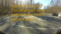
Starting at the , this route offers a slightly longer cross-country effort while maintaining ESNP’s...
★ 5.0 • 5 miles • 700 ft • 6 • Loop •
For riders short on time, this is Chattanooga’s best in-town singletrack option. Located within the city...
10 miles • 684 ft • 4 • Loop •
A family-friendly favorite that highlights ESNP’s smooth, flowing cross-country design. Begin at the...
6 miles • 1,049 ft • 6 •
The perfect introduction to Walden’s Ridge Park’s progressive downhill design. Climb up at a steady...
8 miles • 1,406 ft • 10 • Loop •
For riders craving chunk and consequence, this figure-8 style route blends technical rock features with...
Videos of Hamilton County Mountain Bike
trail: Cottontail
0:07 |
|
Nov 18, 2022
trail: Cottontail
0:10 |
217 |
May 25, 2022

trail: Upper Nutty Buddy
6:39 |
120 |
Mar 17, 2021

trail: Upper Nutty Buddy
7:04 |
178 |
May 9, 2020

trail: Atlas
13:32 |
528 |
May 14, 2019
trail: TNT
16:09 |
241 |
Feb 4, 2017
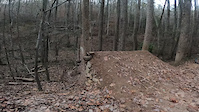
trail: Black Forest
12:40 |
343 |
Jan 17, 2017

trail: Summer
0:28 |
587 |
May 1, 2016
Current Trail Warnings
| status | trail | date | condition | user | info |
|---|---|---|---|---|---|
| Inner Loop 1 Booker T Washington State Park | Jun 15, 2026 @ 8:13pm (America/New_York) 3 days | Variable | maczz SORBA Chatt | Tree cleared. Handsaws work! |
Recent Trail Reports
National Scenic Trails & Official Routes
-
River To Clouds
- Mountain Bike
- E-Bike
- Hike
- Trail Running

Activity Feed
| username | action | type | title | date |
|---|---|---|---|---|
| clw | add | report | activity #97244148 and 1 more | Jun 18, 2026 @ 5:05am 47 mins |
| maczz | comment | report | activity #97227900 | Jun 17, 2026 @ 7:52pm 10 hours |
| DankerSix5 | wishlist | region | activity #97214116 | Jun 17, 2026 @ 3:52pm 14 hours |
| Olsonbp | wishlist | route | activity #97158368 | Jun 16, 2026 @ 7:56pm 1 day |
| maczz | comment | report | activity #97152391 and 3 more | Jun 16, 2026 @ 6:05pm 1 day |
Recent Comments
| username | type | title | comment | date |
|---|---|---|---|---|
| report | Thanks for tackling that downed tree full of... | Jun 17, 2026 @ 7:52pm 10 hours | ||
| report | Trimmed under it. There is no problem riding... | Jun 16, 2026 @ 6:11pm 1 day | ||
| report | Tree cleared 6/16/26 | Jun 16, 2026 @ 6:07pm 1 day | ||
| report | Tree cleared 6/16/26 | Jun 16, 2026 @ 6:06pm 1 day | ||
| report | Tree cleared 6/16/26 | Jun 16, 2026 @ 6:05pm 1 day |
Local Badges
-

Completionist14 awarded -

Mountain Biking 100k Badge2 awarded -

Climbing 10k Badge29 awarded -

Epic Mountain Bike Climb 2k33 awarded -
Completionist12 awarded -

Top 10 Trails14 awarded
Bike & Skill Parks
| name | type | city | rating |
|---|---|---|---|
| Stringer's Pump Track | skill park | Chattanooga |
Activity Type Stats
| activitytype | trails | distance | descent | descent distance | total vertical | rating | global rank | state rank | photos | reports | routes | ridelogs |
|---|---|---|---|---|---|---|---|---|---|---|---|---|
| Mountain Bike | 158 | 221 miles | 23,675 ft | 89 miles | 1,342 ft | 939 | 2,595 | 17 | 62,106 | |||
| E-Bike | 59 | 92 miles | 8,415 ft | 34 miles | 1,230 ft | 7 | 1,336 | 12 | 3,083 | |||
| Gravel Bike | 33 | 75 miles | 6,785 ft | 32 miles | 1,342 ft | 2 | 137 | 1 | 205 | |||
| Adaptive Bike | 34 | 82 miles | 6,345 ft | 34 miles | 1,342 ft | 108 | 1 | 2 | ||||
| Winter Fat Bike | 6 | 3 miles | 545 ft | 2 miles | 453 ft | 54 | ||||||
| Horse | 1 | 2 miles | 105 ft | 5,148 ft | 39 ft | 1 | 328 | 1 | ||||
| Hike | 233 | 363 miles | 45,249 ft | 150 miles | 1,424 ft | 39 | 2,529 | 5 | 4,856 | |||
| Trail Running | 234 | 363 miles | 45,249 ft | 150 miles | 1,424 ft | 5 | 2,527 | 5 | 4,443 |
Frequently Asked Questions About Hamilton County
▼
What are the best places to ride in Hamilton County?
Hamilton County has 17 areas to explore for mountain biking. The top rated areas are:
▼
What are the highest rated mountain biking trails in Hamilton County?
The highest rated mountain biking trails in Hamilton County are:
- Biscuits & Gravy (4.6/5)
- Upper Nutty Buddy (4.6/5)
- DeVito (4.4/5)
- Ollie (4.4/5)
- Gambler (4.4/5)
▼
What is the best time of the year to ride in Hamilton County?
Based on ride log data, the most popular months to ride in Hamilton County are:
- October (247 activities)
- July (246 activities)
- September (234 activities)
▼
What is the longest trail in Hamilton County?
The longest trail in Hamilton County is Atlas at 5.9 miles. View all trails sorted by distance.
Activities
Trails
Points of Interest
- By brenthillier
 NSMBA TRAILFORKS & contributors
 - Admins: SORBA, lscarmic, softbatch, PlumbBobM, SORBA Chatt
- #15172 - 6,412 views
- hamilton county activity log | embed map of Hamilton County mountain bike trails | hamilton county mountain biking points of interest
Downloading of trail gps tracks in kml & gpx formats is enabled for Hamilton County.
You must login to download files.