close
-
Layers w
- Weather Layers
- Pro
- Pro
- Pro
- Pro
- Pro
- Pro
- More Layers
- Pro
- Pro
- Pro
- Pro
-
Upgrade to

3D
Trail Conditions
- Unknown
- Snow Groomed
- Snow Packed
- Snow Covered
- Snow Cover Partial
- Freeze/thaw Cycle
- Icy
- Prevalent Mud
- Wet
- Variable
- Ideal
- Dry
- Very Dry
Trail Flow (Ridden Direction)
Trailforks scans users ridelogs to determine the most popular direction each trail is ridden. A good flowing trail network will have most trails flowing in a single direction according to their intension.
The colour categories are based on what percentage of riders are riding a trail in its intended direction.
The colour categories are based on what percentage of riders are riding a trail in its intended direction.
- > 96%
- > 90%
- > 80%
- > 70%
- > 50%
- < 50%
- bi-directional trail
- no data
Trail Last Ridden
Trailforks scans ridelogs to determine the last time a trail was ridden.
- < 2 days
- < 1 week
- < 2 weeks
- < 1 month
- < 6 months
- > 6 months
Trail Ridden Direction
The intended direction a trail should be ridden.
- Downhill Only
- Downhill Primary
- Both Directions
- Uphill Primary
- Uphill Only
- One Direction
Contribute Details
Colors indicate trail is missing specified detail.
- Description
- Photos
- Description & Photos
- Videos
Trail Popularity ?
Trailforks scans ridelogs to determine which trails are ridden the most in the last 9 months.
Trails are compared with nearby trails in the same city region with a possible 25 colour shades.
Think of this as a heatmap, more rides = more kinetic energy = warmer colors.
- most popular
- popular
- less popular
- not popular
ATV/ORV/OHV Filter
Max Vehicle Width
inches
US Cell Coverage
Legend

Radar Time
Activity Recordings
Trailforks uses anonymized public activity data.
?
Activity Recordings
Trailforks uses anonymized public activity data.
?
Personal Heatmap
▶
Activity Types
all
/
none
▶
Options
2
Date range
month
–
Winter Trails
Warning
A routing network for winter maps does not exist. Selecting trails using the winter trails layer has been disabled.
Missing Trails
Most Popular
Least Popular
Trails are colored based on popularity. The more popular a trail is, the more red. Less popular trails trend towards green.
Jump Magnitude Heatmap
Heatmap of where riders jump on trails. Zoom in to see individual jumps, click circles to view jump details.
BC Backroad Status
![map legend]()
Service Road Atlas is a free to use, community-driven service for viewing and creating reports on the numerous back-country service roads around B.C. and Alberta.

Slope Aspect
Direction the slope faces
Trails Deemphasized
Trails are shown in grey.
Only show trails with no bike usage.
Suggested Layers
Based on selected activity type
Save the current map location and zoom level as your default home location whenever this page is loaded.
SaveThe Beaver Brook Tract Trail network(aka "Hardy Road") is the first mountain bike specific trail system built in the Adirondack Park. Eleven miles of some of the sweetest single track east of the Mississippi traverse both sides of the picturesque Beaver Brook Valley. The valley lies in a rain shadow of Whiteface mountain, and is typically much warmer and drier than surrounding areas. This makes it one of the most popular spots in the region when other trails are too wet to ride.
source: Barkeater Trails Alliance
Primary Trail Type: Cross-Country
eBikes Allowed:
No
AKA: Beaver Brook
Land Status: State Forest
Land Manager: New York State Department of Environmental Conservation(NYSDEC)
 google parking directions
 Access Info:
From the intersection of Route 86 and Route 431 (Whiteface Memorial Highway), follow Route 86 toward Jay. Continue for just under 2.1 miles to Hardy Road on the right. Follow here for around 2.2 miles to the Wilmington Wild Forest, Beaver Brook Tract Trail System (aka. Hardy Road Trails) on your left.
Be careful crossing the road here, especially with children or dogs. Cars drive fast past the parking lot.
The Hardy Road trail network can also be accessed from the Wilmington Youth Park in downtown Wilmington via Noreens Trail and the Three Sisters Trail. Visiting riders who are prepared for a slightly longer ride are advised to use this parking area due to the limited space at the Hardy Road trailhead and the need to limit vehicle traffic on a quiet residential road.
Disclaimer:
This trail network includes New York State Public Forest Preserve lands. Please be advised that legal hunting and trapping activities may be occurring at any time of year within the Forest Preserve.
Activities Click to view
- Mountain Bike
11 trails
- Hike
13 trails
- Trail Running
13 trails
Region Details
- 4
- 5
- 2
Region Status
Caution as of Jun 13, 2026Stats
- Avg Trail Rating
- Trails (view details)
- 12
- Trails Mountain Bike
- 14
- Trails Hike
- 13
- Trails Trail Running
- 13
- Total Distance
- 13 miles
- Total Descent Distance
- 7 miles
- Total Descent
- 2,367 ft
- Total Vertical
- 848 ft
- Highest Trailhead
- 1,793 ft
- Reports
- 603
- Photos
- 49
- Ridden Counter
- 7,537
Popular Hardy Road Mountain Biking Trails
• 95 ★ 3.6 • 1,827 ft • 52 ft • 860 •
Lost Farm is a mellow introductory singletrack trail that can be connected with Coniferous and lower to make an appealing kid-friendly loop. It is also a natural speed-dump for riders descending from the upper portions of All In, so be...
• 90 ★ 3.6 • 3,110 ft • 11 ft • 793 •
This mellow loop makes a nice warm up before a longer ride, or a great place to get a kid dialed in on their first singletrack experience. It's also a useful loop to ride when your buddies are running late and you'd rather not be...
• 95 ★ 4.2 • 4,140 ft • 6 ft • 670 •
lots of great natural features and flowy track built into the landscape.
• 90 ★ 4.4 • 3,740 ft • 88 ft • 664 •
This is a great introduction to the intermediate trails in this network. A few low profile berms, a sneaky drop line, and a very twisty section make this a lot of fun.
• 85 ★ 3.2 • 3,199 ft • 11 ft • 583 •
A mixture of Doubletrack and Singletrack that provides a link up to several of the loops on the West side of Hardy Road.
• 75 ★ 3.4 • 2,136 ft • 44 ft • 519 •
Riding provides a good vantage point for the challenging terrain above that traverses. This rides well in either direction and provides a useful way to make a loop with or Double Time.
Hardy Road Mountain Bike Routes
6 miles • 495 ft • 4 •
While many of the trails at Hardy are challenging, there’s plenty to do with families or beginners. This...
★ 2.0 • 8 miles • 1,268 ft • 7 •
Definitely requires climbing for the fun down hill reward. On the Northwest side of Hardy Road the...
8 miles • 1,359 ft • 6 •
If you’re looking to get straight to the gnarly goodness, this route is for you.
6 miles • 841 ft • 10 •
If you want to hit all the goods this is a good way to do it. Go up the downs and down the ups to get all...
★ 3.0 • 11 miles • 1,322 ft • 14 • Loop •
This is a proposed route for use by Wild Flow Tours LLC.
• 15 miles • 2,068 ft • 15 •
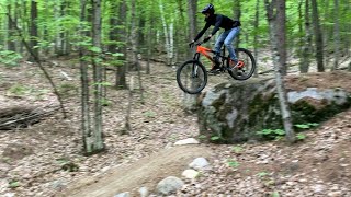
Photos of Hardy Road Mountain Bike


Recent Trail Reports
| status | trail | date | condition | info | user |
|---|---|---|---|---|---|
| Lost Farm | Jun 13, 2026 @ 2:39pm (America/New_York) Jun 13, 2026 | Ideal | TLMD | ||
| Side Pot | Jun 13, 2026 @ 2:39pm (America/New_York) Jun 13, 2026 | Ideal | TLMD | ||
| Flobus | Apr 16, 2026 @ 4:32pm (America/New_York) Apr 16, 2026 | Unknown | meggoes BETA | ||
| Twisted Pine | Apr 16, 2026 @ 4:31pm (America/New_York) Apr 16, 2026 | Unknown | meggoes BETA | ||
| Town Connector | Apr 16, 2026 @ 4:31pm (America/New_York) Apr 16, 2026 | Unknown | meggoes BETA | ||
| Three Sisters Trail (AKA Quaker Mountain Trail) | Apr 16, 2026 @ 4:31pm (America/New_York) Apr 16, 2026 | Unknown | meggoes BETA | ||
| Safe Bet | Apr 16, 2026 @ 4:31pm (America/New_York) Apr 16, 2026 | Unknown | meggoes BETA | ||
| Make Believe | Apr 16, 2026 @ 4:31pm (America/New_York) Apr 16, 2026 | Unknown | meggoes BETA | ||
| Double Time | Apr 16, 2026 @ 4:31pm (America/New_York) Apr 16, 2026 | Unknown | meggoes BETA | ||
| Coniferous Trail | Apr 16, 2026 @ 4:31pm (America/New_York) Apr 16, 2026 | Unknown | meggoes BETA |
Activity Feed
| username | action | type | title | date |
|---|---|---|---|---|
| 000bdr | wishlist | region | activity #97184012 | Jun 17, 2026 @ 7:59am 21 hours |
| TLMD | add | report | activity #96928967 and 1 more | Jun 13, 2026 @ 5:35pm Jun 13, 2026 |
| logancherry56 | wishlist | trail | activity #96400673 and 5 more | Jun 6, 2026 @ 1:08pm Jun 6, 2026 |
| toasteroven666 | wishlist | trail | activity #95575290 | May 26, 2026 @ 10:43am May 26, 2026 |
| toasteroven666 | wishlist | route | activity #95574585 | May 26, 2026 @ 10:33am May 26, 2026 |
Recent Comments
| username | type | title | comment | date |
|---|---|---|---|---|
| report | Open as of 5/5! | May 5, 2026 @ 6:30pm May 5, 2026 | ||
| report | Tree down | Aug 28, 2025 @ 4:32am Aug 28, 2025 | ||
| trail | Great trail! I particularly like the last(?)... | Oct 2, 2023 @ 4:28pm Oct 2, 2023 | ||
| trail | Great trail. Thank you BETA, it is well made... | Sep 29, 2023 @ 4:27am Sep 29, 2023 | ||
| trail | Nice, tight, singletrack. Mellow ride on a... | Sep 1, 2023 @ 7:56pm Sep 1, 2023 |
Nearby Areas
| name | distance | ||||
|---|---|---|---|---|---|
| Flume Trail System | 8 | 7 | 5 | 2.1 km | |
| Whiteface Mountain Ski Center | 4 | 9 | 6 | 5 | 3.1 km |
| East Branch Community Trails | 2 | 8 | 4 km | ||
| Ausable Acres | 2 | 3 | 4.5 km | ||
| Cooper Kiln | 1 | 4.9 km |
Activity Type Stats
| activitytype | trails | distance | descent | descent distance | total vertical | rating | global rank | state rank | photos | reports | routes | ridelogs |
|---|---|---|---|---|---|---|---|---|---|---|---|---|
| Mountain Bike | 11 | 12 miles | 2,234 ft | 6 miles | 768 ft | 44 | 603 | 5 | 5,188 | |||
| Hike | 13 | 12 miles | 2,149 ft | 6 miles | 850 ft | #10,642 | #4,212 | 515 | 93 | |||
| Trail Running | 13 | 12 miles | 2,149 ft | 6 miles | 850 ft | #9,681 | #3,519 | 515 | 188 |
Frequently Asked Questions About Hardy Road
▼
What are the highest rated mountain biking trails in Hardy Road?
The highest rated mountain biking trails in Hardy Road are:
- All In (4.4/5)
- Three Sisters Trail (AKA Quaker Mountain Trail) (4.3/5)
- Twisted Pine (4.2/5)
- Good Luck (4.1/5)
- Beaver Brook (4.1/5)
▼
What is the best time of the year to ride in Hardy Road?
Based on ride log data, the most popular months to ride in Hardy Road are:
- July (150 activities)
- August (138 activities)
- September (108 activities)
▼
Where can I park to ride in Hardy Road?
There are 4 parking locations listed in Hardy Road. The most popular parking spots are: View all parking and trailhead locations on the map to plan your visit.
▼
What is the longest trail in Hardy Road?
The longest trail in Hardy Road is All In at 2.8 miles. View all trails sorted by distance.
Activities
Trails
Points of Interest
- By mopedmatt
 & contributors
 - Admins: mopedmatt, Nkulina, CapnJim, Colinloher, CapnJim, BETA
- #9182 - 16,404 views
- hardy road activity log | embed map of Hardy Road mountain bike trails | hardy road mountain biking points of interest
Downloading of trail gps tracks in kml & gpx formats is enabled for Hardy Road.
You must login to download files.