close
-
Layers w
- Weather Layers
- Pro
- Pro
- Pro
- Pro
- Pro
- Pro
- More Layers
- Pro
- Pro
- Pro
- Pro
-
Upgrade to

3D
Trail Conditions
- Unknown
- Snow Groomed
- Snow Packed
- Snow Covered
- Snow Cover Partial
- Freeze/thaw Cycle
- Icy
- Prevalent Mud
- Wet
- Variable
- Ideal
- Dry
- Very Dry
Trail Flow (Ridden Direction)
Trailforks scans users ridelogs to determine the most popular direction each trail is ridden. A good flowing trail network will have most trails flowing in a single direction according to their intension.
The colour categories are based on what percentage of riders are riding a trail in its intended direction.
The colour categories are based on what percentage of riders are riding a trail in its intended direction.
- > 96%
- > 90%
- > 80%
- > 70%
- > 50%
- < 50%
- bi-directional trail
- no data
Trail Last Ridden
Trailforks scans ridelogs to determine the last time a trail was ridden.
- < 2 days
- < 1 week
- < 2 weeks
- < 1 month
- < 6 months
- > 6 months
Trail Ridden Direction
The intended direction a trail should be ridden.
- Downhill Only
- Downhill Primary
- Both Directions
- Uphill Primary
- Uphill Only
- One Direction
Contribute Details
Colors indicate trail is missing specified detail.
- Description
- Photos
- Description & Photos
- Videos
Trail Popularity ?
Trailforks scans ridelogs to determine which trails are ridden the most in the last 9 months.
Trails are compared with nearby trails in the same city region with a possible 25 colour shades.
Think of this as a heatmap, more rides = more kinetic energy = warmer colors.
- most popular
- popular
- less popular
- not popular
ATV/ORV/OHV Filter
Max Vehicle Width
inches
US Cell Coverage
Legend

Radar Time
Activity Recordings
Trailforks uses anonymized public activity data.
?
Activity Recordings
Trailforks uses anonymized public activity data.
?
Personal Heatmap
▶
Activity Types
all
/
none
▶
Options
2
Date range
month
–
Winter Trails
Warning
A routing network for winter maps does not exist. Selecting trails using the winter trails layer has been disabled.
Missing Trails
Most Popular
Least Popular
Trails are colored based on popularity. The more popular a trail is, the more red. Less popular trails trend towards green.
Jump Magnitude Heatmap
Heatmap of where riders jump on trails. Zoom in to see individual jumps, click circles to view jump details.
BC Backroad Status
![map legend]()
Service Road Atlas is a free to use, community-driven service for viewing and creating reports on the numerous back-country service roads around B.C. and Alberta.

Slope Aspect
Direction the slope faces
Trails Deemphasized
Trails are shown in grey.
Only show trails with no bike usage.
Suggested Layers
Based on selected activity type
Save the current map location and zoom level as your default home location whenever this page is loaded.
SaveNorsk
«Byen med fire fjell». Harstad og området rundt har et enormt antall terrengsykkelstier. Lister over stier er fortsatt under arbeid.
English
"City of Four Mountains". Harstad and the adjacent area has a massive amount of mountain biking trails. Trail listings are still in the making.
«Byen med fire fjell». Harstad og området rundt har et enormt antall terrengsykkelstier. Lister over stier er fortsatt under arbeid.
English
"City of Four Mountains". Harstad and the adjacent area has a massive amount of mountain biking trails. Trail listings are still in the making.
Links
- https://www.harstad.kommune.no/
- https://en.wikipedia.org/wiki/Harstad
- https://no.wikipedia.org/wiki/Harstad
- Harstad Enduro on FB
- Article about Harstad in magazine Terrengsykkel
This region uses the Uk/Euro style trail grading system.
Activities Click to view
- Mountain Bike
193 trails
- E-Bike
185 trails
- Adaptive Bike
0 trails
- Winter Fat Bike
1 trails
- Horse
24 trails
- Hike
193 trails
- Trail Running
182 trails
- Dirtbike/Moto
5 trails
- ATV/ORV/OHV
10 trails
- Snowmobile
9 trails
- Snowshoe
28 trails
- Downhill Ski
26 trails
- Backcountry Ski
28 trails
- Nordic Ski
43 trails
Region Details
- 32
- 28
- 106
- 19
- 6
- 1
Region Status
Open as of 9 hoursLocal Trail Association
Stats
- Avg Trail Rating
- Trails (view details)
- 199
- Trails Mountain Bike
- 193
- Trails E-Bike
- 185
- Trails Winter Fat Bike
- 1
- Trails Horse
- 24
- Trails Hike
- 193
- Trails Trail Running
- 182
- Trails Dirtbike/Moto
- 5
- Trails ATV/ORV/OHV
- 10
- Trails Snowmobile
- 9
- Trails Snowshoe
- 28
- Trails Downhill Ski
- 26
- Trails Backcountry Ski
- 28
- Trails Nordic Ski
- 43
- Total Distance
- 146 miles
- Total Descent
- 52,813 ft
- Total Vertical
- 3,741 ft
- Highest Trailhead
- 3,743 ft
- Reports
- 1,276
- Photos
- 179
- Ridden Counter
- 4,823
Articles
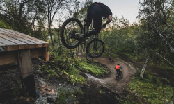
Photo Story: 68 Degrees North - The Story of Harstad Bike Park
Dec 17, 2022 from pinkbike.com
Dan Griffiths captures the Arctic MTB Mecca of Harstad Bike Park.
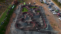
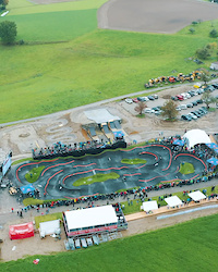
Race Report: 68 Degrees North - Pump Track World Championships Norwegian Qualifier at the Brand New Harstad Sykkelpark
Sep 6, 2022 from pinkbike.com
2022 saw the Red Bull UCI Pump Track World Championships host its first Norwegian Qualifier at the brand new Harstad Sykkelpark, just one day...
Sub Regions
-
Folkeparken
- 12
- 34
- 6
- 1
-
Hagebyen
- 21
- 2
-
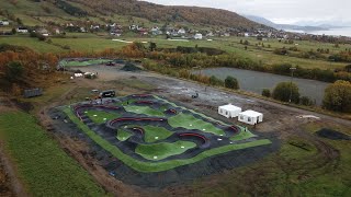
Harstad Bike Park
- 7
- 2
- 2
- 2
-
Kilhusåsen
- 4
-
Rolla
- 2
- 3
- 3
- 1
- 1
-
Sandsøya
- 1
- 1
-
Sørsia
- 5
- 24
- 1
- 2
Popular Harstad Mountain Biking Trails
• 65 ★ 3.5 • 1,145 ft • 2 ft • 129 •
Moderately popular red difficulty machine groomed. This mountain bike primary trail can be used downhill only and has a moderate overall physical rating. It features jump, rock face and rock garden. Trail visibility is always easy to follow. On average it takes 3 minutes to complete this trail.
• 95 ★ 3.0 • 2,044 ft • 20 ft • 125 •
Popular blue difficulty singletrack. This mountain bike primary trail can be used downhill only and has a moderate overall physical rating. It features berm, bridge and wallride. Trail visibility is always easy to follow. On average it takes 3 minutes to complete this trail.
• 90 ★ 5.0 • 663 ft • 0 ft • 119 •
Popular green difficulty machine groomed. This mountain bike primary trail can be used uphill primary and has a moderate overall physical rating with a 0 ft green climb. Trail visibility is always easy to follow. On average it takes minutes to complete this trail.
• 100 ★ 0.0 • 604 ft • 2 ft • 115 •
Popular green difficulty machine groomed. This mountain bike primary trail can be used downhill only and has a easy overall physical rating. Trail visibility is always easy to follow. On average it takes 2 minutes to complete this trail.
• 75 ★ 0.0 • 548 ft • 0 ft • 107 •
Popular green difficulty singletrack. This mountain bike primary trail can be used both directions with a 0 ft green climb. On average it takes 5 minutes to complete this trail.
• 50 ★ 3.0 • 1,427 ft • 14 ft • 103 •
Moderately popular green difficulty machine groomed. This mountain bike primary trail can be used downhill only. Trail visibility is always easy to follow. On average it takes 1 minutes to complete this trail.
• 60 ★ 4.0 • 1,555 ft • 43 ft • 102 •
Moderately popular blue difficulty machine groomed. This mountain bike primary trail can be used uphill primary and has a moderate overall physical rating with a 43 ft green climb. Trail visibility is always easy to follow. On average it takes 2 minutes to complete this trail.
• 100 ★ 4.7 • 4,298 ft • 162 ft • 96 •
Nice singletrack with small rock gardens and cruxes. Primary connection to the classic trails and Svartdalsåsen West.
Harstad Mountain Bike Routes
16 miles • 1,255 ft • 0 • Loop •
Route from Folkeparken to Tømmeråsen and back.
★ 5.0 • 17 miles • 3,686 ft • 11 • Point to Point • Race •
FE1: 10:15-11:25 GRØNNKOLLTUVA - MUSVANNET FE2: 10:25-11:50 SVARTDALSÅSEN - HARSTADVANNET (Pause 15 min...
★ 5.0 • 17 miles • 4,005 ft • 16 • Point to Point • Race •
Harstad Enduro Race skal være et sportslig tilskudd innenfor endurogrenen i Nord-Norge. Rittet skal ha...
16 miles • 3,223 ft • 38 • Point to Point • Race •
Lørdag 22. september: 09:00: Offentliggjøring av etapper på...
18 miles • 3,816 ft • 36 • Point to Point • Race •
12:00 Offentliggjøring av etapper på Trailforks. Besiktigelse på eget initiativ ved hjelp av...
1 mile • 164 ft • 4 • Point to Point • Race •
12:00 Offentliggjøring av etapper på Trailforks. Besiktigelse på eget initiativ ved hjelp av...
Photos of Harstad Mountain Bike
Videos of Harstad Mountain Bike
trail: Svartdalsåsen - Skytterbanen
0:11 |
12 |
Aug 8, 2024
2:04 |
86 |
Apr 7, 2020
0:08 |
56 |
Oct 7, 2018

47 |
Jul 13, 2025 , Harstad
0:12 |
325 |
Oct 13, 2020

0:06 |
282 |
Oct 13, 2020
0:39 |
39 |
Jul 12, 2020
Current Trail Warnings
| status | trail | date | condition | user | info |
|---|---|---|---|---|---|
| Musvannet - Pevannet | May 27, 2026 @ 5:39pm (Europe/Oslo) May 27, 2026 | Wet | nikknet | E-Bike Alle trær er kuttet og fjernet. |
Recent Trail Reports
Activity Feed
| username | action | type | title | date |
|---|---|---|---|---|
| Roy-w | add | report | activity #97402204 and 2 more | Jun 20, 2026 @ 9:05am 9 hours |
| Roy-w | ridden | trail | activity #97402074 and 5 more | Jun 20, 2026 @ 9:04am 9 hours |
| Roy-w | ridden | trail | activity #97402047 and 1 more | Jun 20, 2026 @ 9:04am 9 hours |
| Sivkristoffersen | update | event | activity #97238869 | Jun 18, 2026 @ 2:11am 3 days |
| Sivkristoffersen | add | event | activity #97236741 | Jun 18, 2026 @ 12:46am 3 days |
Recent Comments
| username | type | title | comment | date |
|---|---|---|---|---|
| trail | Good trail, needs some push biking if ridden... | Aug 20, 2023 @ 11:51pm Aug 20, 2023 | ||
| trail | Flowy trails with great views, watch out for... | Aug 20, 2023 @ 11:46pm Aug 20, 2023 | ||
| trail | Really fun trail with a bit of everything | Aug 20, 2023 @ 11:45pm Aug 20, 2023 | ||
| trail | A bit overgrown in some places but a really... | Aug 20, 2023 @ 11:44pm Aug 20, 2023 | ||
| trail | One of the best trails in the area, a bit of... | Aug 20, 2023 @ 3:25am Aug 20, 2023 |
Local Badges
-

Completionist0 awarded -

Big Ride 30k383 awarded -

Epic Ride 50k151 awarded -

Top 10 Trails0 awarded -
Completionist0 awarded -
Completionist0 awarded
Bike & Skill Parks
| name | type | city | rating |
|---|---|---|---|
| Harstad Bike Park | bike park | Harstad | |
| Small Pump Tracks at Harstad Bike Park | skill park | Harstad | |
| Freestyleparken at Harstad Bike Park | skill park | Harstad | |
| Pumptrack 68°N at Harstad Bike Park | skill park | Harstad | |
| Dirt Pump Track at Seljestad skole | skill park | Harstad |
Upcoming Local Events
Activity Type Stats
| activitytype | trails | distance | descent | descent distance | total vertical | rating | global rank | state rank | photos | reports | routes | ridelogs |
|---|---|---|---|---|---|---|---|---|---|---|---|---|
| Mountain Bike | 193 | 136 miles | 46,473 ft | 74 miles | 3,232 ft | #647 | #7 | 178 | 1,276 | 9 | 5,039 | |
| E-Bike | 185 | 136 miles | 46,473 ft | 74 miles | 3,232 ft | #346 | #8 | 1 | 1,171 | 1 | 2,862 | |
| Winter Fat Bike | 1 | #72 | #22 | |||||||||
| Horse | 24 | 30 miles | 8,471 ft | 14 miles | 3,189 ft | #208 | #2 | 701 | ||||
| Hike | 193 | 144 miles | 52,126 ft | 78 miles | 3,740 ft | #579 | #9 | 1,273 | 1,076 | |||
| Trail Running | 182 | 139 miles | 50,433 ft | 76 miles | 3,740 ft | #438 | #9 | 1,240 | 593 | |||
| Dirtbike/Moto | 5 | 3 miles | 594 ft | 4,760 ft | 863 ft | #250 | #2 | 701 | 2 | |||
| ATV/ORV/OHV | 10 | 17 miles | 3,593 ft | 8 miles | 1,181 ft | #117 | #1 | 248 | ||||
| Snowmobile | 9 | 15 miles | 3,488 ft | 7 miles | 1,181 ft | #56 | #1 | |||||
| Snowshoe | 28 | 43 miles | 17,782 ft | 23 miles | 3,740 ft | #84 | #3 | 19 | ||||
| Downhill Ski | 26 | 38 miles | 16,900 ft | 21 miles | 3,740 ft | #241 | #4 | 182 | ||||
| Backcountry Ski | 28 | 43 miles | 17,782 ft | 23 miles | 3,740 ft | #130 | #5 | 513 | ||||
| Nordic Ski | 43 | 40 miles | 17,162 ft | 21 miles | 3,740 ft | #128 | #11 | 609 |
Frequently Asked Questions About Harstad
▼
What are the best places to ride in Harstad?
Harstad has 7 areas to explore for mountain biking. The top rated areas are:
▼
What are the highest rated mountain biking trails in Harstad?
The highest rated mountain biking trails in Harstad are:
- Kjersti stien (4.4/5)
- Storhornet (4.4/5)
- Svartdalsåsen - Landsåsbanen "Sykkelsti" (4.3/5)
- Hinnstein - Breivikhaugen (4.3/5)
- Svartdalsåsen - Skytterbanen (4.3/5)
▼
What is the best time of the year to ride in Harstad?
Based on ride log data, the most popular months to ride in Harstad are:
- August (49 activities)
- July (36 activities)
- September (23 activities)
▼
Where can I park to ride in Harstad?
There are 14 parking locations listed in Harstad. The most popular parking spots are:
- Small Parking Lot by the Club House at Harstad Bikepark
- Parking
- Large Parking Lot at Harstad Bike Park
- Parking
- Parking
Activities
- Harstad Mountain Biking Trails
- Harstad E-Biking Trails
- Harstad Horseback Trails
- Harstad Hiking Trails
- Harstad Trail Running Trails
- Harstad Dirtbiking Trails
- Harstad ATVing/Offroading Trails
- Harstad Snowmobiling Trails
- Harstad Snowshoeing Trails
- Harstad Skiing Trails
- Harstad Backcountry Skiing Trails
- Harstad Nordic Skiing Trails
Trails
Points of Interest
- Shelter Camping
- Maistua Camping
- Trondenes Historical Centre Sight
- Trailhead Summit
- Information Board with Trail Maps, Rules and Trailforks Map of the Harstad Region
- Viewpoint with Shelter and BBQ
- Drangen Summit
- Midttinden Summit
- Middagstinden Summit
- Aarbostadtinden Summit
- Saetertinden (1,080 m)
- Skjellesvikgalten (975 m)
- Nona (968 m)
- By maristam
 HE & contributors
 - Admins: HE, maristam
- #20118 - 13,903 views
- harstad activity log | embed map of Harstad mountain bike trails | harstad mountain biking points of interest polygons
Downloading of trail gps tracks in kml & gpx formats is enabled for Harstad.
You must login to download files.