close
-
Layers w
- Weather Layers
- Pro
- Pro
- Pro
- Pro
- Pro
- Pro
- More Layers
- Pro
- Pro
- Pro
- Pro
-
Upgrade to

3D
Trail Conditions
- Unknown
- Snow Groomed
- Snow Packed
- Snow Covered
- Snow Cover Partial
- Freeze/thaw Cycle
- Icy
- Prevalent Mud
- Wet
- Variable
- Ideal
- Dry
- Very Dry
Trail Flow (Ridden Direction)
Trailforks scans users ridelogs to determine the most popular direction each trail is ridden. A good flowing trail network will have most trails flowing in a single direction according to their intension.
The colour categories are based on what percentage of riders are riding a trail in its intended direction.
The colour categories are based on what percentage of riders are riding a trail in its intended direction.
- > 96%
- > 90%
- > 80%
- > 70%
- > 50%
- < 50%
- bi-directional trail
- no data
Trail Last Ridden
Trailforks scans ridelogs to determine the last time a trail was ridden.
- < 2 days
- < 1 week
- < 2 weeks
- < 1 month
- < 6 months
- > 6 months
Trail Ridden Direction
The intended direction a trail should be ridden.
- Downhill Only
- Downhill Primary
- Both Directions
- Uphill Primary
- Uphill Only
- One Direction
Contribute Details
Colors indicate trail is missing specified detail.
- Description
- Photos
- Description & Photos
- Videos
Trail Popularity ?
Trailforks scans ridelogs to determine which trails are ridden the most in the last 9 months.
Trails are compared with nearby trails in the same city region with a possible 25 colour shades.
Think of this as a heatmap, more rides = more kinetic energy = warmer colors.
- most popular
- popular
- less popular
- not popular
ATV/ORV/OHV Filter
Max Vehicle Width
inches
US Cell Coverage
Legend

Radar Time
Activity Recordings
Trailforks uses anonymized public activity data.
?
Activity Recordings
Trailforks uses anonymized public activity data.
?
Personal Heatmap
▶
Activity Types
all
/
none
▶
Options
2
Date range
month
–
Winter Trails
Warning
A routing network for winter maps does not exist. Selecting trails using the winter trails layer has been disabled.
Missing Trails
Most Popular
Least Popular
Trails are colored based on popularity. The more popular a trail is, the more red. Less popular trails trend towards green.
Jump Magnitude Heatmap
Heatmap of where riders jump on trails. Zoom in to see individual jumps, click circles to view jump details.
BC Backroad Status
![map legend]()
Service Road Atlas is a free to use, community-driven service for viewing and creating reports on the numerous back-country service roads around B.C. and Alberta.

Slope Aspect
Direction the slope faces
Trails Deemphasized
Trails are shown in grey.
Only show trails with no bike usage.
Suggested Layers
Based on selected activity type
Save the current map location and zoom level as your default home location whenever this page is loaded.
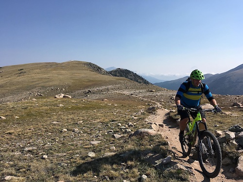
SaveHartman Rocks Recreation Area offers over 40 miles of single track for beginner to expert riders. The trails wander through rolling hills of sagebrush interspersed with granite rock formations and Cottonwood groves.
source: BLM Colorado
Primary Trail Type: Cross-Country
Land Status: Managed by Local Riding Association
 google parking directions
Links
Activities Click to view
- Mountain Bike
92 trails
- E-Bike
86 trails
- Horse
44 trails
- Hike
94 trails
- Trail Running
94 trails
- Dirtbike/Moto
46 trails
- ATV/ORV/OHV
14 trails
- Backcountry Ski
6 trails
- Nordic Ski
0 trails
Region Details
- 31
- 2
- 16
- 30
- 11
- 1
Region Status
Open as of Jun 13, 2026Local Trail Association
Stats
- Avg Trail Rating
- Trails (view details)
- 94
- Trails Mountain Bike
- 92
- Trails E-Bike
- 86
- Trails Horse
- 44
- Trails Hike
- 94
- Trails Trail Running
- 94
- Trails Dirtbike/Moto
- 46
- Trails ATV/ORV/OHV
- 14
- Trails Backcountry Ski
- 6
- Total Distance
- 107 miles
- Total Descent
- 15,037 ft
- Total Vertical
- 2,805 ft
- Highest Trailhead
- 10,334 ft
- Reports
- 489
- Photos
- 182
- Ridden Counter
- 38,484
Popular Hartman Rocks Mountain Biking Trails
• 100 ★ 4.4 • 1,919 ft • 151 ft • 1,515 •
Highly rated popular blue difficulty singletrack. This multi-use trail can be used uphill primary and has a moderate overall physical rating with a 151 ft blue climb. On average it takes 4 minutes to complete this trail.
• 100 ★ 4.1 • 1,932 ft • 0 ft • 1,443 •
Highly rated popular blue difficulty singletrack. This multi-use trail can be used both directions and has a moderate overall physical rating with a 0 ft blue climb. On average it takes 1 minutes to complete this trail.
• 95 ★ 4.2 • 3,182 ft • 81 ft • 1,426 •
Highly rated popular blue difficulty singletrack. This multi-use trail can be used both directions and has a moderate overall physical rating with a 81 ft blue climb. On average it takes 5 minutes to complete this trail.
• 100 ★ 4.4 • 2,405 ft • 125 ft • 1,363 •
Popular green difficulty singletrack. This multi-use trail can be used downhill primary and has a easy overall physical rating with a 125 ft green climb. On average it takes 4 minutes to complete this trail.
• 95 ★ 4.6 • 5,089 ft • 221 ft • 1,203 •
Highly rated popular black diamond difficulty singletrack. This multi-use trail can be used downhill primary and has a hard overall physical rating with a 221 ft black diamond climb. On average it takes 12 minutes to complete this trail.
• 5 ★ 4.3 • 2 miles • 332 ft • 1,188 •
Highly rated less popular blue difficulty singletrack. This multi-use trail can be used both directions and has a moderate overall physical rating with a 332 ft blue climb. On average it takes 15 minutes to complete this trail.
• 95 ★ 3.8 • 1 mile • 223 ft • 1,082 •
Popular green difficulty singletrack. This multi-use trail can be used both directions and has a easy overall physical rating with a 223 ft green climb. On average it takes 11 minutes to complete this trail.
Hartman Rocks Mountain Bike Routes
★ 5.0 • 11 miles • 1,504 ft • 24 •
This loop hits most of the fun technical trails in Hartmans Rocks. You can take the at the top of to cut...
★ 5.0 • 17 miles • 2,331 ft • 52 •
Start up jacks, then head over to to the ridge. After ride up Top of the World, and use the cutoff trail...
★ 5.0 • 18 miles • 2,226 ft • 11 •
A fun loop covering the more cross-country trails of Hartman Rocks
9 miles • 1,272 ft • 7 •
★ 1.0 • 1 mile • 99 ft • 1 • Point to Point •
A short singletrack that packs punch. More technical in its nature, offers slick rock rolls and high-speed...
12 miles • 1,736 ft • 15 • Loop •
This is a recommend ride from in Gunnison, CO. This loop at Hartman Rocks has some technical sections and...
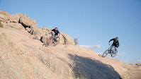
Photos of Hartman Rocks Mountain Bike
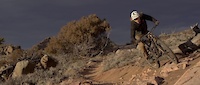
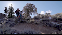
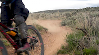
Videos of Hartman Rocks Mountain Bike

trail: Hartman Rocks Dr
0:05 |
683 |
Oct 14, 2020
trail: Behind the Rocks
0:58 |
127 |
Jan 15, 2020
trail: Skull Pass
0:53 |
423 |
Nov 13, 2018
trail: Free Fall
0:30 |
1100 |
Nov 27, 2017
trail: Becks
0:17 |
149 |
May 22, 2016

trail: Jacks
2:16 |
155 |
Sep 8, 2014

trail: Jacks
0:21 |
677 |
Sep 7, 2014
trail: Back In
13:08 |
455 |
Dec 10, 2013
Recent Trail Reports
| status | trail | date | condition | info | user |
|---|---|---|---|---|---|
| Gold Basin Road | Jun 13, 2026 @ 9:14am (America/Denver) Jun 13, 2026 | Unknown | benny503k4W | ||
| Jacks | Apr 10, 2026 @ 11:53am (America/Denver) Apr 10, 2026 | Dry | acornty | ||
| Lower Jacks | Apr 10, 2026 @ 11:53am (America/Denver) Apr 10, 2026 | Dry | acornty | ||
| Collarbone Alley | Apr 10, 2026 @ 11:53am (America/Denver) Apr 10, 2026 | Dry | acornty | ||
| Behind the Rocks | Apr 10, 2026 @ 11:53am (America/Denver) Apr 10, 2026 | Dry | acornty | ||
| Behind the Rocks Access | Apr 10, 2026 @ 11:53am (America/Denver) Apr 10, 2026 | Dry | acornty | ||
| Becks | Apr 10, 2026 @ 11:53am (America/Denver) Apr 10, 2026 | Dry | acornty | ||
| Sky Line | Oct 28, 2025 @ 9:26am (America/Denver) Oct 28, 2025 | Ideal | acornty | ||
| Lost Dog | Aug 10, 2025 @ 12:13pm Aug 10, 2025 | Dry | Thomas9wVvja | ||
| Sea of Sage Alt Entrance | Aug 10, 2025 @ 12:13pm Aug 10, 2025 | Dry | Thomas9wVvja |
National Scenic Trails & Official Routes
-
Colorado Trail (Bike)
- Mountain Bike
Activity Feed
| username | action | type | title | date |
|---|---|---|---|---|
| ESP-OFF | wishlist | trail | activity #97748334 | Jun 24, 2026 @ 10:19pm Jun 24, 2026 |
| Tnbikerboy | ridden | route | activity #97708707 | Jun 24, 2026 @ 10:39am Jun 24, 2026 |
| Zacharyyk8vgx | ridden | trail | activity #97708185 | Jun 24, 2026 @ 10:32am Jun 24, 2026 |
| garrettdimoncom | ridden | trail | activity #97683071 and 4 more | Jun 24, 2026 @ 2:12am Jun 24, 2026 |
| garrettdimoncom | wishlist | region | activity #97682311 | Jun 24, 2026 @ 1:38am Jun 24, 2026 |
Recent Comments
| username | type | title | comment | date |
|---|---|---|---|---|
| trail | felt super hard my first run. once you figure... | Apr 24, 2026 @ 12:28pm Apr 24, 2026 | ||
| trail | agree it's a very good and fairly challenging... | Apr 24, 2026 @ 12:10pm Apr 24, 2026 | ||
| trail | Yep, it's not Rattlesnake! Personally I find... | Apr 5, 2026 @ 6:44pm Apr 5, 2026 | ||
| trail | This is definitely not a blue and should be... | Sep 24, 2025 @ 7:06am Sep 24, 2025 | ||
| trail | Sooo much fun! Yes it's uppity! Yes it's... | Sep 21, 2025 @ 11:25am Sep 21, 2025 |
Nearby Areas
| name | distance | ||||
|---|---|---|---|---|---|
| Signal Peak | 8 | 12 | 1 | 6.9 km | |
| Spring Creek | 2 | 9 | 10 | 23.2 km | |
| Kebler Pass | 3 | 11 | 5 | 25 km | |
| Cement Creek | 1 | 10 | 14 | 26.1 km | |
| Crested Butte Town Trails | 12 | 8 | 9 | 27 km |
Local Badges
-

Completionist0 awarded
Local Mountain Biking Directory
-
Gunnison Trails
![Gunnison Trails]()
-
Rock N Roll SportsBike Shop
-
All Sports ReplayBike Shop
-
Tomichi CyclesBike Shop
-
Race Townie BicyclesBike Shop
Activity Type Stats
| activitytype | trails | distance | descent | descent distance | total vertical | rating | global rank | state rank | photos | reports | routes | ridelogs |
|---|---|---|---|---|---|---|---|---|---|---|---|---|
| Mountain Bike | 92 | 104 miles | 14,875 ft | 50 miles | 2,789 ft | #504 | #193 | 165 | 489 | 25 | 12,228 | |
| E-Bike | 86 | 98 miles | 14,232 ft | 47 miles | 2,789 ft | #628 | #603 | 15 | 472 | 3 | 512 | |
| Horse | 44 | 55 miles | 9,236 ft | 28 miles | 2,789 ft | #780 | #412 | 158 | ||||
| Hike | 94 | 106 miles | 14,954 ft | 50 miles | 2,805 ft | #1,640 | #730 | 489 | 3 | 551 | ||
| Trail Running | 94 | 106 miles | 14,954 ft | 50 miles | 2,805 ft | #1,017 | #323 | 2 | 489 | 3 | 498 | |
| Dirtbike/Moto | 46 | 58 miles | 9,600 ft | 29 miles | 2,736 ft | #438 | #107 | 170 | 26 | |||
| ATV/ORV/OHV | 14 | 24 miles | 4,167 ft | 14 miles | 2,736 ft | #389 | #108 | 147 | 2 | |||
| Backcountry Ski | 6 | 9 miles | 758 ft | 3 miles | 646 ft | #325 | #78 | 1 | 3 |
Frequently Asked Questions About Hartman Rocks
▼
What are the highest rated mountain biking trails in Hartman Rocks?
The highest rated mountain biking trails in Hartman Rocks are:
- Gateway (4.5/5)
- The Ridge (4.4/5)
- Rattlesnake (4.4/5)
- Free Fall (4.4/5)
- Josho's (4.3/5)
▼
What is the best time of the year to ride in Hartman Rocks?
Based on ride log data, the most popular months to ride in Hartman Rocks are:
- July (152 activities)
- September (104 activities)
- August (103 activities)
▼
Where can I park to ride in Hartman Rocks?
There are 10 parking locations listed in Hartman Rocks. The most popular parking spots are: View all parking and trailhead locations on the map to plan your visit.
▼
What is the longest trail in Hartman Rocks?
The longest trail in Hartman Rocks is Aberdeen Loop (E) at 3.9 miles. View all trails sorted by distance.
Activities
- By mountainbikesoul & contributors
- Admins: Gunnison, Gunnison
- #6401 - 24,108 views
- hartman rocks activity log | embed map of Hartman Rocks mountain bike trails | hartman rocks mountain biking points of interest
Downloading of trail gps tracks in kml & gpx formats is enabled for Hartman Rocks.
You must login to download files.