close
-
Layers w
- Weather Layers
- Pro
- Pro
- Pro
- Pro
- Pro
- Pro
- More Layers
- Pro
- Pro
- Pro
- Pro
-
Upgrade to

3D
Trail Conditions
- Unknown
- Snow Groomed
- Snow Packed
- Snow Covered
- Snow Cover Partial
- Freeze/thaw Cycle
- Icy
- Prevalent Mud
- Wet
- Variable
- Ideal
- Dry
- Very Dry
Trail Flow (Ridden Direction)
Trailforks scans users ridelogs to determine the most popular direction each trail is ridden. A good flowing trail network will have most trails flowing in a single direction according to their intension.
The colour categories are based on what percentage of riders are riding a trail in its intended direction.
The colour categories are based on what percentage of riders are riding a trail in its intended direction.
- > 96%
- > 90%
- > 80%
- > 70%
- > 50%
- < 50%
- bi-directional trail
- no data
Trail Last Ridden
Trailforks scans ridelogs to determine the last time a trail was ridden.
- < 2 days
- < 1 week
- < 2 weeks
- < 1 month
- < 6 months
- > 6 months
Trail Ridden Direction
The intended direction a trail should be ridden.
- Downhill Only
- Downhill Primary
- Both Directions
- Uphill Primary
- Uphill Only
- One Direction
Contribute Details
Colors indicate trail is missing specified detail.
- Description
- Photos
- Description & Photos
- Videos
Trail Popularity ?
Trailforks scans ridelogs to determine which trails are ridden the most in the last 9 months.
Trails are compared with nearby trails in the same city region with a possible 25 colour shades.
Think of this as a heatmap, more rides = more kinetic energy = warmer colors.
- most popular
- popular
- less popular
- not popular
ATV/ORV/OHV Filter
Max Vehicle Width
inches
US Cell Coverage
Legend

Radar Time
Activity Recordings
Trailforks uses anonymized public activity data.
?
Activity Recordings
Trailforks uses anonymized public activity data.
?
Personal Heatmap
▶
Activity Types
all
/
none
▶
Options
2
Date range
month
–
Winter Trails
Warning
A routing network for winter maps does not exist. Selecting trails using the winter trails layer has been disabled.
Missing Trails
Most Popular
Least Popular
Trails are colored based on popularity. The more popular a trail is, the more red. Less popular trails trend towards green.
Jump Magnitude Heatmap
Heatmap of where riders jump on trails. Zoom in to see individual jumps, click circles to view jump details.
BC Backroad Status
![map legend]()
Service Road Atlas is a free to use, community-driven service for viewing and creating reports on the numerous back-country service roads around B.C. and Alberta.

Slope Aspect
Direction the slope faces
Trails Deemphasized
Trails are shown in grey.
Only show trails with no bike usage.
Suggested Layers
Based on selected activity type
Save the current map location and zoom level as your default home location whenever this page is loaded.
Save
No description for Helensburgh has been added yet!
Login or register to submit one.
Activities Click to view
- Mountain Bike
105 trails
- E-Bike
41 trails
- Gravel Bike
0 trails
- Adaptive Bike
0 trails
- Winter Fat Bike
0 trails
- Horse
6 trails
- Hike
106 trails
- Trail Running
105 trails
- Dirtbike/Moto
5 trails
- ATV/ORV/OHV
2 trails
Region Details
- 12
- 16
- 62
- 8
- 3
Region Status
Caution as of May 22, 2026Stats
- Avg Trail Rating
- Trails (view details)
- 101
- Trails Mountain Bike
- 105
- Trails E-Bike
- 41
- Trails Horse
- 6
- Trails Hike
- 106
- Trails Trail Running
- 105
- Trails Dirtbike/Moto
- 5
- Trails ATV/ORV/OHV
- 2
- Total Distance
- 57 miles
- Total Descent
- 9,829 ft
- Total Vertical
- 1,171 ft
- Highest Trailhead
- 1,334 ft
- Reports
- 417
- Photos
- 303
- Ridden Counter
- 10,779
Sub Regions
-
Helensburgh Park
- 13
- 55
- 7
- 3
Popular Helensburgh Mountain Biking Trails
• 85 ★ 4.0 • 4,364 ft • 40 ft • 342 •
Popular green difficulty singletrack. This mountain bike primary trail can be used one direction and has a easy overall physical rating with a 40 ft green climb. It features jump and teeter totter. On average it takes 8 minutes to complete this trail.
• 100 ★ 0.0 • 462 ft • 5 ft • 334 •
Popular blue difficulty singletrack. This mountain bike primary trail can be used both directions and has a moderate overall physical rating with a 5 ft blue climb. On average it takes minutes to complete this trail.
• 95 ★ 0.0 • 570 ft • 0 ft • 295 •
Popular blue difficulty singletrack. This mountain bike primary trail can be used downhill only and has a moderate overall physical rating. It features berm, drop and wallride. On average it takes 2 minutes to complete this trail.
• 90 ★ 3.0 • 1,181 ft • 30 ft • 281 •
Popular black diamond difficulty singletrack. This mountain bike primary trail can be used downhill primary. On average it takes 1 minutes to complete this trail.
• 100 ★ 4.5 • 410 ft • 0 ft • 273 •
Popular blue difficulty singletrack. This mountain bike primary trail can be used downhill primary. It features rock garden. On average it takes 1 minutes to complete this trail.
• 85 ★ 3.5 • 676 ft • 6 ft • 265 •
Popular green difficulty singletrack. This mountain bike primary trail can be used both directions and has a easy overall physical rating with a 6 ft green climb. On average it takes minutes to complete this trail.
• 100 ★ 0.0 • 801 ft • 13 ft • 263 •
Popular blue difficulty singletrack. This mountain bike primary trail can be used both directions and has a moderate overall physical rating with a 13 ft blue climb. It features rock garden. On average it takes minutes to complete this trail.
• 85 ★ 0.0 • 463 ft • 6 ft • 251 •
Popular blue difficulty singletrack. This mountain bike primary trail can be used both directions and has a easy overall physical rating with a 6 ft green climb. It features rock garden. On average it takes minutes to complete this trail.
Helensburgh Mountain Bike Routes
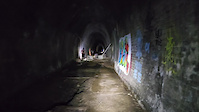
★ 5.0 • 4 miles • 814 ft • 0 • Loop •
Interesting ride doen 1.6km long disused railway tunnel, return loop to Otford station
★ 4.0 • 2 miles • 78 ft • 0 • Point to Point •
Road linking Helensburgh Pub at high end of Helensburgh with the train station at the lowest end of...
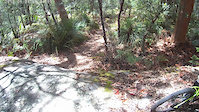
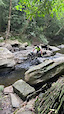
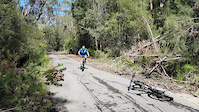
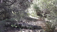
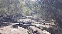
Photos of Helensburgh Mountain Bike
Videos of Helensburgh Mountain Bike

trail: Cawleys Road
0:10 |
28 |
Aug 9, 2023
trail: New Denman
0:12 |
34 |
Aug 5, 2023
trail: Burgh Trail to Hacking River
0:16 |
22 |
Aug 5, 2023
trail: Cawleys Road
0:26 |
24 |
Aug 5, 2023
trail: The Red Road
0:15 |
12 |
Aug 5, 2023
trail: The Red Road
0:15 |
10 |
Aug 5, 2023
trail: Otford Tunnel Loop
0:15 |
190 |
Feb 13, 2023

trail: Tip Turkey
0:00 |
3036 |
Oct 16, 2017
Current Trail Warnings
| status | trail | date | condition | user | info |
|---|---|---|---|---|---|
| Garra Loop Upper | May 23, 2026 @ 10:43am (Australia/Sydney) May 22, 2026 | Unknown | MTB-AUS | ||
| Helensburgh 29 | May 23, 2026 @ 10:43am (Australia/Sydney) May 22, 2026 | Unknown | MTB-AUS | ||
| Blackstump | May 23, 2026 @ 10:43am (Australia/Sydney) May 22, 2026 | Unknown | MTB-AUS |
Recent Trail Reports
| status | trail | date | condition | info | user |
|---|---|---|---|---|---|
| Flat Rock Trail | May 23, 2026 @ 10:43am (Australia/Sydney) May 22, 2026 | Variable | MTB-AUS | ||
| Cawleys Road | May 23, 2026 @ 10:43am (Australia/Sydney) May 22, 2026 | Dry | MTB-AUS | ||
| StruggleTown | May 23, 2026 @ 10:43am (Australia/Sydney) May 22, 2026 | Variable | MTB-AUS | ||
| Dam Trail | May 23, 2026 @ 10:43am (Australia/Sydney) May 22, 2026 | Variable | MTB-AUS | ||
| Pallet | May 23, 2026 @ 10:43am (Australia/Sydney) May 22, 2026 | Dry | MTB-AUS | ||
| slip n slide | May 23, 2026 @ 10:43am (Australia/Sydney) May 22, 2026 | Variable | MTB-AUS | ||
| Stevies | May 23, 2026 @ 10:43am (Australia/Sydney) May 22, 2026 | Variable | MTB-AUS | ||
| Helensburgh 21 | May 23, 2026 @ 10:43am (Australia/Sydney) May 22, 2026 | Dry | MTB-AUS | ||
| Rajani Express | May 23, 2026 @ 10:43am (Australia/Sydney) May 22, 2026 | Dry | MTB-AUS | ||
| Trig Trail Link | May 17, 2026 @ 5:59am (Australia/Sydney) May 16, 2026 | Ideal | Trichard3 |
Activity Feed
| username | action | type | title | date |
|---|---|---|---|---|
| fanool | wishlist | trail | activity #96151008 | Jun 3, 2026 @ 6:33am Jun 3, 2026 |
| Nicklebaut | ridden | trail | activity #96108992 | Jun 2, 2026 @ 2:12pm Jun 2, 2026 |
| Grant59 | wishlist | region | activity #95982617 | May 31, 2026 @ 3:28pm May 31, 2026 |
| MTB-AUS | add | report | activity #95307812 | May 23, 2026 @ 5:31am May 23, 2026 |
| MTB-AUS | add | report | activity #95307806 and 10 more | May 23, 2026 @ 5:31am May 23, 2026 |
Recent Comments
| username | type | title | comment | date |
|---|---|---|---|---|
| trail | This really is not a mountain bike track, I... | Mar 21, 2026 @ 5:32pm Mar 21, 2026 | ||
| trail | Lots of loose rock and big chunky rocks, hard... | Dec 19, 2025 @ 12:48pm Dec 19, 2025 | ||
| trail | Overgrown, needs some work but still fun | May 13, 2025 @ 11:04pm May 13, 2025 | ||
| trail | Rode from Garawarra carpark down to Hacking... | Apr 9, 2025 @ 12:41am Apr 9, 2025 | ||
| trail | Basically reclaimed by the forest | Feb 27, 2025 @ 12:58pm Feb 27, 2025 |
Local Badges
-

10 Blue Trails149 awarded -

Epic Ride Climb 2k77 awarded -

Climbing 10k Badge61 awarded -

Climbing 100k Badge3 awarded -

Epic Ride Descent 2k77 awarded -

Descent 10k Badge61 awarded
Activity Type Stats
| activitytype | trails | distance | descent | descent distance | total vertical | rating | global rank | state rank | photos | reports | routes | ridelogs |
|---|---|---|---|---|---|---|---|---|---|---|---|---|
| Mountain Bike | 105 | 57 miles | 9,829 ft | 26 miles | 1,171 ft | #1,286 | #71 | 299 | 417 | 2 | 7,668 | |
| E-Bike | 41 | 27 miles | 4,347 ft | 12 miles | 1,171 ft | #2,710 | #137 | 3 | 343 | 2 | 946 | |
| Horse | 6 | 2,638 ft | 177 ft | 2,051 ft | 276 ft | #867 | #45 | 12 | 5 | |||
| Hike | 106 | 50 miles | 8,323 ft | 23 miles | 1,171 ft | #911 | #30 | 1 | 407 | 2 | 1,210 | |
| Trail Running | 105 | 51 miles | 8,373 ft | 23 miles | 1,171 ft | #2,463 | #71 | 405 | 3 | 867 | ||
| Dirtbike/Moto | 5 | 1 mile | 180 ft | 3,058 ft | 157 ft | #494 | #21 | 7 | 35 | |||
| ATV/ORV/OHV | 2 | 135 ft | 20 ft | #348 | #18 | 6 |
Frequently Asked Questions About Helensburgh
▼
What are the best places to ride in Helensburgh?
Helensburgh has 1 areas to explore for mountain biking. The top rated areas are:
▼
What are the highest rated mountain biking trails in Helensburgh?
The highest rated mountain biking trails in Helensburgh are:
- Lower Dead Horse (4.1/5)
- Garrawarra Ridge (4.1/5)
- Upper Dead Horse (4.1/5)
- Terry (4.1/5)
- Otford Tunnel Loop (4.1/5)
▼
What is the best time of the year to ride in Helensburgh?
Based on ride log data, the most popular months to ride in Helensburgh are:
- July (86 activities)
- October (75 activities)
- February (69 activities)
▼
Where can I park to ride in Helensburgh?
There are 8 parking locations listed in Helensburgh. The most popular parking spots are: View all parking and trailhead locations on the map to plan your visit.
Activities
Trails
Points of Interest
- By Addzz
 TRAILFORKS NEMTB & contributors
 - Admins: stuartrichardson, NSW NPWS
- #16867 - 16,676 views
- helensburgh activity log | embed map of Helensburgh mountain bike trails | helensburgh mountain biking points of interest
Downloading of trail gps tracks in kml & gpx formats is enabled for Helensburgh.
You must login to download files.