close
-
Layers w
- Weather Layers
- Pro
- Pro
- Pro
- Pro
- Pro
- Pro
- More Layers
- Pro
- Pro
- Pro
- Pro
-
Upgrade to

3D
Trail Conditions
- Unknown
- Snow Groomed
- Snow Packed
- Snow Covered
- Snow Cover Partial
- Freeze/thaw Cycle
- Icy
- Prevalent Mud
- Wet
- Variable
- Ideal
- Dry
- Very Dry
Trail Flow (Ridden Direction)
Trailforks scans users ridelogs to determine the most popular direction each trail is ridden. A good flowing trail network will have most trails flowing in a single direction according to their intension.
The colour categories are based on what percentage of riders are riding a trail in its intended direction.
The colour categories are based on what percentage of riders are riding a trail in its intended direction.
- > 96%
- > 90%
- > 80%
- > 70%
- > 50%
- < 50%
- bi-directional trail
- no data
Trail Last Ridden
Trailforks scans ridelogs to determine the last time a trail was ridden.
- < 2 days
- < 1 week
- < 2 weeks
- < 1 month
- < 6 months
- > 6 months
Trail Ridden Direction
The intended direction a trail should be ridden.
- Downhill Only
- Downhill Primary
- Both Directions
- Uphill Primary
- Uphill Only
- One Direction
Contribute Details
Colors indicate trail is missing specified detail.
- Description
- Photos
- Description & Photos
- Videos
Trail Popularity ?
Trailforks scans ridelogs to determine which trails are ridden the most in the last 9 months.
Trails are compared with nearby trails in the same city region with a possible 25 colour shades.
Think of this as a heatmap, more rides = more kinetic energy = warmer colors.
- most popular
- popular
- less popular
- not popular
ATV/ORV/OHV Filter
Max Vehicle Width
inches
US Cell Coverage
Legend

Radar Time
Activity Recordings
Trailforks uses anonymized public activity data.
?
Activity Recordings
Trailforks uses anonymized public activity data.
?
Personal Heatmap
▶
Activity Types
all
/
none
▶
Options
2
Date range
month
–
Winter Trails
Warning
A routing network for winter maps does not exist. Selecting trails using the winter trails layer has been disabled.
Missing Trails
Most Popular
Least Popular
Trails are colored based on popularity. The more popular a trail is, the more red. Less popular trails trend towards green.
Jump Magnitude Heatmap
Heatmap of where riders jump on trails. Zoom in to see individual jumps, click circles to view jump details.
BC Backroad Status
![map legend]()
Service Road Atlas is a free to use, community-driven service for viewing and creating reports on the numerous back-country service roads around B.C. and Alberta.

Slope Aspect
Direction the slope faces
Trails Deemphasized
Trails are shown in grey.
Only show trails with no bike usage.
Suggested Layers
Based on selected activity type
Save the current map location and zoom level as your default home location whenever this page is loaded.
SaveSingle-track trails by the east bank of the Snake River. Nice grassy camping areas with trees and natural shade in the state park. The trails have no trees or shade, so be prepared for a warm ride in the afternoon summer sun. Great views over Asotin, Clarkston, Craig Mountain and the north edge of Hells Canyon. A couple routes have significant climbs of 500-800 feet. Most of the trails are navigable for a novice rider with a few technical sections. Due to the minimal snow at this low elevation and the sandy soil that dries quickly, these trails can be ridden year round. Hells Gate is a popular spot for hiking and horseback riding also.
source: Visit Lewis Clark Valley
 google parking directions
Links
Activities Click to view
- Mountain Bike
19 trails
- E-Bike
19 trails
- Hike
19 trails
- Trail Running
19 trails
Region Details
- 3
- 8
- 5
- 3
Region Status
Caution as of Sep 18, 2025Stats
- Avg Trail Rating
- Trails (view details)
- 19
- Trails Mountain Bike
- 19
- Trails E-Bike
- 19
- Trails Hike
- 19
- Trails Trail Running
- 19
- Total Distance
- 14 miles
- Total Descent
- 2,485 ft
- Total Vertical
- 659 ft
- Highest Trailhead
- 1,403 ft
- Reports
- 110
- Photos
- 19
- Ridden Counter
- 1,538
Popular Hells Gate Mountain Biking Trails
• 95 ★ 4.5 • 4,328 ft • 91 ft • 123 •
Popular blue difficulty singletrack. This mountain bike primary trail can be used downhill primary. On average it takes 5 minutes to complete this trail.
• 80 ★ 3.8 • 2,723 ft • 42 ft • 97 •
Straight shot with a few minor off camber corners. Rock garden/rock slab about 2/3 the way down. Watch out for hikers coming up. Don’t want to go to the bottom? Take the cutoff to the right about 1/2 way down.
• 75 ★ 0.0 • 1,547 ft • 65 ft • 80 •
Popular green difficulty singletrack. This mountain bike primary trail can be used both directions. On average it takes 3 minutes to complete this trail.
• 45 ★ 0.0 • 4,040 ft • 126 ft • 70 •
Moderately popular green difficulty singletrack. This mountain bike primary trail. On average it takes 8 minutes to complete this trail.
• 55 ★ 5.0 • 4,490 ft • 150 ft • 70 •
Moderately popular black diamond difficulty singletrack. This mountain bike primary trail can be used uphill primary. On average it takes 9 minutes to complete this trail.
• 50 ★ 0.0 • 4,021 ft • 175 ft • 66 •
Moderately popular blue difficulty singletrack. This mountain bike primary trail can be used uphill primary. On average it takes 7 minutes to complete this trail.
• 55 ★ 0.0 • 1,998 ft • 182 ft • 64 •
Moderately popular black diamond difficulty singletrack. This mountain bike primary trail. On average it takes 4 minutes to complete this trail.
Photos of Hells Gate Mountain Bike
Recent Trail Reports
| status | trail | date | condition | info | user |
|---|---|---|---|---|---|
| Sundown Cutoff | Sep 13, 2025 @ 8:00am (America/Los_Angeles) Sep 13, 2025 | Unknown | Ninerider | ||
| Jawbone | Sep 13, 2025 @ 8:00am (America/Los_Angeles) Sep 13, 2025 | Unknown | Ninerider | ||
| The Rollers | Mar 1, 2025 @ 11:37am Mar 1, 2025 | Ideal | MoscowMatt | ||
| Griffin's Cutoff | Mar 1, 2025 @ 11:37am Mar 1, 2025 | Ideal | MoscowMatt | ||
| Kip's Cutoff | Mar 1, 2025 @ 11:37am Mar 1, 2025 | Ideal | MoscowMatt | ||
| Warren's Ridge | Mar 1, 2025 @ 11:37am Mar 1, 2025 | Ideal | MoscowMatt | ||
| Easy Street | Jul 20, 2024 @ 12:08am Jul 20, 2024 | Ideal | BvqG1pg | ||
| Gunpowder Ridge | Jan 25, 2024 @ 4:58pm Jan 25, 2024 | Variable | benhZ9Txh | ||
| Charlie's Peak | Jan 25, 2024 @ 4:57pm Jan 25, 2024 | Dry | benhZ9Txh | ||
| Sundown | Jan 25, 2024 @ 4:56pm Jan 25, 2024 | Variable | benhZ9Txh |
Activity Feed
| username | action | type | title | date |
|---|---|---|---|---|
| RobdqsNIq | ridden | trail | activity #88545404 and 3 more | Feb 8, 2026 @ 12:18am Feb 8, 2026 |
| Ninerider | add | report | activity #80613093 and 1 more | Sep 18, 2025 @ 11:37am Sep 18, 2025 |
| JennaGermany | wishlist | trail | activity #74345315 | Jun 22, 2025 @ 9:25am Jun 22, 2025 |
| Scott928 | wishlist | region | activity #69723487 | Apr 15, 2025 @ 9:05pm Apr 15, 2025 |
| hjbald | wishlist | trail | activity #68079820 and 13 more | Mar 20, 2025 @ 6:28am Mar 20, 2025 |
Recent Comments
| username | type | title | comment | date |
|---|---|---|---|---|
| trail | This is our favorite trail at Hell's Gate.... | May 4, 2023 @ 8:34pm May 4, 2023 | ||
| trail | The top part of Kip's is steep and fast with a... | Jun 1, 2022 @ 12:51pm Jun 1, 2022 | ||
| report | That’s probably horses, which are allowed... | Dec 29, 2021 @ 4:20pm Dec 29, 2021 | ||
| report | This trail always seems to be destroyed from... | Dec 28, 2021 @ 7:56am Dec 28, 2021 | ||
| trail | The lower part of this trail is routed... | Mar 14, 2021 @ 11:03am Mar 14, 2021 |
Nearby Areas
| name | distance | ||||
|---|---|---|---|---|---|
| Skinner Canyon | 6 | 7 | 3 | 2 | 5.1 km |
| Craig Mountain | 7 | 13 | 2 | 10.7 km | |
| Touchet River Valley | 2 | 4 | 1 | 24.5 km | |
| Moscow Mountain | 29 | 27 | 1 | 32.9 km |
Local Mountain Biking Directory
-
Valley Off Road Bicycling Association
![Valley Off Road Bicycling Association]()
-
Follett's Mountain SportsBike Shop
-
Ride On BikesBike Shop
-
Tnt CyclesBike Shop
Activity Type Stats
| activitytype | trails | distance | descent | descent distance | total vertical | rating | global rank | state rank | photos | reports | routes | ridelogs |
|---|---|---|---|---|---|---|---|---|---|---|---|---|
| Mountain Bike | 19 | 14 miles | 2,484 ft | 6 miles | 659 ft | 19 | 110 | 1,295 | ||||
| E-Bike | 19 | 14 miles | 2,484 ft | 6 miles | 659 ft | #6,163 | #1,743 | 67 | 56 | |||
| Hike | 19 | 14 miles | 2,484 ft | 6 miles | 659 ft | #10,755 | #4,281 | 110 | 108 | |||
| Trail Running | 19 | 14 miles | 2,484 ft | 6 miles | 659 ft | #9,159 | #3,283 | 110 | 323 |
Frequently Asked Questions About Hells Gate
▼
What are the highest rated mountain biking trails in Hells Gate?
The highest rated mountain biking trails in Hells Gate are:
- Everest Trail (4.1/5)
- The Rollers (4.1/5)
- Laurel Vista (4/5)
- Sundown (4/5)
- Devil's Slide (3.9/5)
▼
What is the best time of the year to ride in Hells Gate?
Based on ride log data, the most popular months to ride in Hells Gate are:
- May (30 activities)
- March (28 activities)
- February (21 activities)
▼
Where can I park to ride in Hells Gate?
There are 3 parking locations listed in Hells Gate. The most popular parking spots are: View all parking and trailhead locations on the map to plan your visit.
▼
What is the longest trail in Hells Gate?
The longest trail in Hells Gate is River Run at 2.2 miles. View all trails sorted by distance.
Activities
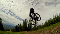
- By chuktA
 TRAILFORKS NFTA & contributors
 - Admins: VORBA
- #25731 - 4,896 views
- hells gate activity log | embed map of Hells Gate mountain bike trails | hells gate mountain biking points of interest
Downloading of trail gps tracks in kml & gpx formats is enabled for Hells Gate.
You must login to download files.