close
-
Layers w
- Weather Layers
- Pro
- Pro
- Pro
- Pro
- Pro
- Pro
- More Layers
- Pro
- Pro
- Pro
- Pro
-
Upgrade to

3D
Trail Conditions
- Unknown
- Snow Groomed
- Snow Packed
- Snow Covered
- Snow Cover Partial
- Freeze/thaw Cycle
- Icy
- Prevalent Mud
- Wet
- Variable
- Ideal
- Dry
- Very Dry
Trail Flow (Ridden Direction)
Trailforks scans users ridelogs to determine the most popular direction each trail is ridden. A good flowing trail network will have most trails flowing in a single direction according to their intension.
The colour categories are based on what percentage of riders are riding a trail in its intended direction.
The colour categories are based on what percentage of riders are riding a trail in its intended direction.
- > 96%
- > 90%
- > 80%
- > 70%
- > 50%
- < 50%
- bi-directional trail
- no data
Trail Last Ridden
Trailforks scans ridelogs to determine the last time a trail was ridden.
- < 2 days
- < 1 week
- < 2 weeks
- < 1 month
- < 6 months
- > 6 months
Trail Ridden Direction
The intended direction a trail should be ridden.
- Downhill Only
- Downhill Primary
- Both Directions
- Uphill Primary
- Uphill Only
- One Direction
Contribute Details
Colors indicate trail is missing specified detail.
- Description
- Photos
- Description & Photos
- Videos
Trail Popularity ?
Trailforks scans ridelogs to determine which trails are ridden the most in the last 9 months.
Trails are compared with nearby trails in the same city region with a possible 25 colour shades.
Think of this as a heatmap, more rides = more kinetic energy = warmer colors.
- most popular
- popular
- less popular
- not popular
ATV/ORV/OHV Filter
Max Vehicle Width
inches
US Cell Coverage
Legend

Radar Time
Activity Recordings
Trailforks uses anonymized public activity data.
?
Activity Recordings
Trailforks uses anonymized public activity data.
?
Personal Heatmap
▶
Activity Types
all
/
none
▶
Options
2
Date range
month
–
Winter Trails
Warning
A routing network for winter maps does not exist. Selecting trails using the winter trails layer has been disabled.
Missing Trails
Most Popular
Least Popular
Trails are colored based on popularity. The more popular a trail is, the more red. Less popular trails trend towards green.
Jump Magnitude Heatmap
Heatmap of where riders jump on trails. Zoom in to see individual jumps, click circles to view jump details.
BC Backroad Status
![map legend]()
Service Road Atlas is a free to use, community-driven service for viewing and creating reports on the numerous back-country service roads around B.C. and Alberta.

Slope Aspect
Direction the slope faces
Trails Deemphasized
Trails are shown in grey.
Only show trails with no bike usage.
Suggested Layers
Based on selected activity type
Save the current map location and zoom level as your default home location whenever this page is loaded.
Save
No description for Hendersonville has been added yet!
Login or register to submit one.
Activities Click to view
- Mountain Bike
20 trails
- E-Bike
18 trails
- Gravel Bike
11 trails
- Adaptive Bike
6 trails
- Hike
36 trails
- Trail Running
37 trails
- Snowshoe
15 trails
- Nordic Ski
15 trails
Region Details
- 3
- 4
- 3
- 5
- 4
- 1
Region Status
Open as of May 2, 2026Stats
- Avg Trail Rating
- Trails (view details)
- 50
- Trails Mountain Bike
- 20
- Trails E-Bike
- 18
- Trails Gravel Bike
- 11
- Trails Adaptive Bike
- 6
- Trails Winter Fat Bike
- 1
- Trails Horse
- 1
- Trails Hike
- 36
- Trails Trail Running
- 37
- Trails Snowshoe
- 15
- Trails Nordic Ski
- 15
- Total Distance
- 38 miles
- Total Descent Distance
- 18 miles
- Total Descent
- 6,524 ft
- Total Vertical
- 2,067 ft
- Highest Trailhead
- 4,132 ft
- Reports
- 396
- Photos
- 142
- Ridden Counter
- 30,839
Articles

Video: Neko Mulally Tests Tires with Kenda
Jan 20, 2021 from pinkbike.com
Neko Mulally rides and gives feedback on some of the tires that Kenda has been working on.
Video: Opening Weekend at Ride Kanuga in North Carolina with Neko Mulally
Jul 30, 2020 from pinkbike.com
The closest you'll get to Whismas in North Carolina.
Sub Regions
-
Kanuga Conference & Retreat
-
Ride Kanuga Bike Park
- 3
- 5
- 3
- 1
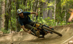
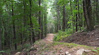
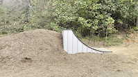
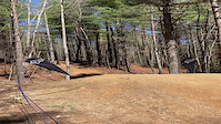
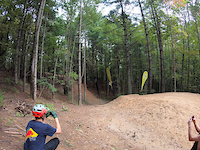
Popular Hendersonville Mountain Biking Trails
• 100 ★ 4.9 • 942 ft • 0 ft • 2,636 •
Our crowd favorite jump line, feel like a hero on safe and fun table tops, step up and downs!
• 95 ★ 4.4 • 1,486 ft • 0 ft • 2,550 •
Easier, beginner friendly jump line as an alternative to Tortuga.
• 50 ★ 4.8 • 3,304 ft • 0 ft • 2,483 •
Our blue flow trail has options for doubles and gaps in sniper mode. fast and furious with corners to challenge the pros. come get you some.
• 70 ★ 4.5 • 3,297 ft • 0 ft • 2,364 •
Progressive natural 'loam' trail with optional features including log ride, gap jumps and step ups
• 55 ★ 4.9 • 3,488 ft • 0 ft • 2,035 •
Great mix of flow trail with progressive mix of gaps and natural log step up and downs.
• 65 ★ 4.6 • 1 mile • 0 ft • 1,913 •
is Kanuga's progressive green downhill trail with rollers and safe options for jumps. Fun for all abilities!
• 25 ★ 4.9 • 2,605 ft • 0 ft • 1,849 •
Very large jumps, advanced riders only. Expert jumping skills required.
• 80 ★ 3.9 • 3,576 ft • 0 ft • 1,250 •
New blue "technical" trail similar to with a mix of berms and flat turns
Hendersonville Mountain Bike Routes
6 miles • 732 ft • 3 • Loop •
Forest road climbs lead to a raw loop then descends into one of the only flow lines around. Watch out for...
★ 5.0 • 8 miles • 2,092 ft • 0 • Loop •
This is one of our favorite routes in Green River and is featured in Freehub Magazine's Pisgah Photo Book:...
14 miles • 3,226 ft • 15 • Race •
The Cranksgiving Kanuga Enduro Race Course for 2024
Photos of Hendersonville Mountain Bike
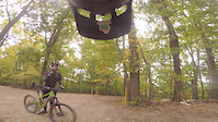
Videos of Hendersonville Mountain Bike
trail: Natural Selection
0:04 |
663 |
Dec 17, 2022
trail: Southeast Style
0:34 |
142 |
Oct 10, 2022
trail: Corn Mountain Loop
0:44 |
56 |
Sep 9, 2022
trail: Tortuga
0:20 |
133 |
Oct 25, 2021
trail: Corn Mountain Loop
0:09 |
|
Oct 22, 2021

trail: Tortuga
0:39 |
121 |
Oct 19, 2021
trail: Tortuga
0:19 |
|
May 17, 2021
trail: Tortuga
0:19 |
332 |
Feb 5, 2021
Recent Trail Reports
| status | trail | date | condition | info | user |
|---|---|---|---|---|---|
| Paint it Black | May 2, 2026 @ 11:10am (America/New_York) May 2, 2026 | Very Dry | BigAssAdam CVTA | ||
| Deadwood | May 2, 2026 @ 11:10am (America/New_York) May 2, 2026 | Very Dry | BigAssAdam CVTA | ||
| Rhodo Ruckus | May 2, 2026 @ 11:10am (America/New_York) May 2, 2026 | Very Dry | BigAssAdam CVTA | ||
| Bee Keeper | May 2, 2026 @ 11:10am (America/New_York) May 2, 2026 | Very Dry | BigAssAdam CVTA | ||
| Hemlock Epoch | May 2, 2026 @ 11:10am (America/New_York) May 2, 2026 | Very Dry | BigAssAdam CVTA | ||
| Southeast Style | May 2, 2026 @ 11:10am (America/New_York) May 2, 2026 | Very Dry | BigAssAdam CVTA | ||
| Natural Selection | May 2, 2026 @ 11:10am (America/New_York) May 2, 2026 | Very Dry | BigAssAdam CVTA | ||
| Copperhead Road | May 2, 2026 @ 11:10am (America/New_York) May 2, 2026 | Very Dry | BigAssAdam CVTA | ||
| First in Flight | May 2, 2026 @ 11:10am (America/New_York) May 2, 2026 | Very Dry | BigAssAdam CVTA | ||
| GNCC | May 2, 2026 @ 11:10am (America/New_York) May 2, 2026 | Very Dry | BigAssAdam CVTA |
Activity Feed
| username | action | type | title | date |
|---|---|---|---|---|
| belacssomed | comment | trail | activity #96987288 | Jun 14, 2026 @ 11:01am Jun 14, 2026 |
| NimblePossum | wishlist | trail | activity #96541311 | Jun 8, 2026 @ 8:25am Jun 8, 2026 |
| VriderX | wishlist | region | activity #96528401 | Jun 8, 2026 @ 3:20am Jun 8, 2026 |
| nateolmsted | vote | trail | activity #96416413 | Jun 6, 2026 @ 4:55pm Jun 6, 2026 |
| adaptivemike | ridden | trail | activity #96252044 and 1 more | Jun 4, 2026 @ 2:24pm Jun 4, 2026 |
Recent Comments
| username | type | title | comment | date |
|---|---|---|---|---|
| trail | Can't say I love this.. the downhill is over... | Jun 14, 2026 @ 11:01am Jun 14, 2026 | ||
| trail | As of Aug. 2025 Trailforks shows all 12 miles... | Aug 28, 2025 @ 6:24am Aug 28, 2025 | ||
| report | noravelp 0 mins ago The trail is not closed in... | Aug 27, 2025 @ 1:28pm Aug 27, 2025 | ||
| report | The trail is not closed in Henderson County, I... | Aug 27, 2025 @ 1:25pm Aug 27, 2025 | ||
| report | To the uninitiated, there is no signage saying... | Aug 27, 2025 @ 12:30pm Aug 27, 2025 |
Local Badges
-

Completionist 20205 awarded -

Epic Mountain Bike Climb 2k75 awarded -

Climbing 10k Badge85 awarded -

Mountain Biking 100k Badge4 awarded -

Epic Ride Descent 2k75 awarded -

Descent 10k Badge85 awarded
Bike & Skill Parks
| name | type | city | rating |
|---|---|---|---|
| Ride Kanuga Bike Park | bike park | Hendersonville | |
| Hendersonville Bike Park | skill park | Hendersonville |
Activity Type Stats
| activitytype | trails | distance | descent | descent distance | total vertical | rating | global rank | state rank | photos | reports | routes | ridelogs |
|---|---|---|---|---|---|---|---|---|---|---|---|---|
| Mountain Bike | 20 | 20 miles | 4,272 ft | 11 miles | 758 ft | #628 | #236 | 141 | 383 | 4 | 20,716 | |
| E-Bike | 18 | 19 miles | 4,045 ft | 10 miles | 758 ft | #1,842 | #903 | 363 | 1 | 3,386 | ||
| Gravel Bike | 11 | 16 miles | 643 ft | 6 miles | 745 ft | #499 | #1,064 | 6 | 101 | |||
| Adaptive Bike | 6 | 11 miles | 217 ft | 4 miles | 745 ft | #383 | #757 | 49 | 1 | |||
| Winter Fat Bike | 1 | 3 miles | 49 ft | 4,196 ft | 59 ft | #384 | #206 | 2 | ||||
| Horse | 1 | 4,688 ft | 98 ft | 2,913 ft | 72 ft | 1 | ||||||
| Hike | 36 | 29 miles | 2,569 ft | 12 miles | 2,067 ft | #3,651 | #1,284 | 1 | 352 | 1,017 | ||
| Trail Running | 37 | 30 miles | 3,058 ft | 12 miles | 2,067 ft | #3,490 | #1,031 | 355 | 693 | |||
| Snowshoe | 15 | 6 miles | 384 ft | 2 miles | 518 ft | #958 | #466 | 4 | ||||
| Nordic Ski | 15 | 6 miles | 384 ft | 2 miles | 518 ft | #1,048 | #446 | 3 |
Frequently Asked Questions About Hendersonville
▼
What are the best places to ride in Hendersonville?
Hendersonville has 3 areas to explore for mountain biking. The top rated areas are:
▼
What are the highest rated mountain biking trails in Hendersonville?
The highest rated mountain biking trails in Hendersonville are:
- Tortuga (4.7/5)
- Hemlock Epoch (4.7/5)
- Rhodo Ruckus (4.6/5)
- Southeast Style (4.5/5)
- Evergreen (4.4/5)
▼
What is the best time of the year to ride in Hendersonville?
Based on ride log data, the most popular months to ride in Hendersonville are:
- July (109 activities)
- May (79 activities)
- November (68 activities)
▼
Where can I park to ride in Hendersonville?
There are 7 parking locations listed in Hendersonville. The most popular parking spots are: View all parking and trailhead locations on the map to plan your visit.
Activities
Trails
- By blowmyfuse
 & contributors
 - Admins: apply
- #6284 - 10,089 views
- hendersonville activity log | embed map of Hendersonville mountain bike trails | hendersonville mountain biking points of interest
Downloading of trail gps tracks in kml & gpx formats is enabled for Hendersonville.
You must login to download files.