close
-
Layers w
- Weather Layers
- Pro
- Pro
- Pro
- Pro
- Pro
- Pro
- More Layers
- Pro
- Pro
- Pro
- Pro
-
Upgrade to

3D
Trail Conditions
- Unknown
- Snow Groomed
- Snow Packed
- Snow Covered
- Snow Cover Partial
- Freeze/thaw Cycle
- Icy
- Prevalent Mud
- Wet
- Variable
- Ideal
- Dry
- Very Dry
Trail Flow (Ridden Direction)
Trailforks scans users ridelogs to determine the most popular direction each trail is ridden. A good flowing trail network will have most trails flowing in a single direction according to their intension.
The colour categories are based on what percentage of riders are riding a trail in its intended direction.
The colour categories are based on what percentage of riders are riding a trail in its intended direction.
- > 96%
- > 90%
- > 80%
- > 70%
- > 50%
- < 50%
- bi-directional trail
- no data
Trail Last Ridden
Trailforks scans ridelogs to determine the last time a trail was ridden.
- < 2 days
- < 1 week
- < 2 weeks
- < 1 month
- < 6 months
- > 6 months
Trail Ridden Direction
The intended direction a trail should be ridden.
- Downhill Only
- Downhill Primary
- Both Directions
- Uphill Primary
- Uphill Only
- One Direction
Contribute Details
Colors indicate trail is missing specified detail.
- Description
- Photos
- Description & Photos
- Videos
Trail Popularity ?
Trailforks scans ridelogs to determine which trails are ridden the most in the last 9 months.
Trails are compared with nearby trails in the same city region with a possible 25 colour shades.
Think of this as a heatmap, more rides = more kinetic energy = warmer colors.
- most popular
- popular
- less popular
- not popular
ATV/ORV/OHV Filter
Max Vehicle Width
inches
US Cell Coverage
Legend

Radar Time
Activity Recordings
Trailforks uses anonymized public activity data.
?
Activity Recordings
Trailforks uses anonymized public activity data.
?
Personal Heatmap
▶
Activity Types
all
/
none
▶
Options
2
Date range
month
–
Winter Trails
Warning
A routing network for winter maps does not exist. Selecting trails using the winter trails layer has been disabled.
Missing Trails
Most Popular
Least Popular
Trails are colored based on popularity. The more popular a trail is, the more red. Less popular trails trend towards green.
Jump Magnitude Heatmap
Heatmap of where riders jump on trails. Zoom in to see individual jumps, click circles to view jump details.
BC Backroad Status
![map legend]()
Service Road Atlas is a free to use, community-driven service for viewing and creating reports on the numerous back-country service roads around B.C. and Alberta.

Slope Aspect
Direction the slope faces
Trails Deemphasized
Trails are shown in grey.
Only show trails with no bike usage.
Suggested Layers
Based on selected activity type
Save the current map location and zoom level as your default home location whenever this page is loaded.
Save
No description for Heredia has been added yet!
Login or register to submit one.
Activities Click to view
- Mountain Bike
14 trails
- E-Bike
10 trails
- Adaptive Bike
0 trails
- Hike
8 trails
- Trail Running
12 trails
Region Details
- 4
- 2
- 5
- 3
Region Status
Open as of Aug 16, 2025Stats
- Avg Trail Rating
- Trails (view details)
- 17
- Trails Mountain Bike
- 14
- Trails E-Bike
- 10
- Trails Hike
- 8
- Trails Trail Running
- 12
- Total Distance
- 10 miles
- Total Descent Distance
- 6 miles
- Total Descent
- 4,039 ft
- Total Vertical
- 2,790 ft
- Highest Trailhead
- 8,818 ft
- Reports
- 93
- Photos
- 166
- Ridden Counter
- 1,395
Sub Regions
-
Adventure Park
- 4
- 2
Popular Heredia Mountain Biking Trails
• 75 ★ 3.0 • 594 ft • 57 ft • 98 •
Popular green difficulty family friendly singletrack. This multi-use trail can be used both directions and has a easy overall physical rating with a 57 ft green climb. On average it takes 1 minutes to complete this trail.
• 100 ★ 4.0 • 1 mile • 502 ft • 95 •
Popular green difficulty family friendly singletrack. This mountain bike primary trail can be used uphill only and has a hard overall physical rating with a 502 ft blue climb. On average it takes 17 minutes to complete this trail.
• 30 ★ 4.4 • 2,228 ft • 0 ft • 93 •
Less popular black diamond difficulty singletrack. This multi-use trail can be used downhill only and has a hard overall physical rating. It features bridge, drop and jump. On average it takes 6 minutes to complete this trail.
• 50 ★ 5.0 • 1 mile • 15 ft • 90 •
Moderately popular blue difficulty singletrack. This mountain bike primary trail can be used downhill only and has a moderate overall physical rating. On average it takes 8 minutes to complete this trail.
• 70 ★ 5.0 • 4,938 ft • 0 ft • 88 •
This trail is pretty straight forward... The gap jump is pretty big but flows well. It is located near the top of the trail. There is a chicken line to the left...
• 90 ★ 4.5 • 4,242 ft • 0 ft • 81 •
Popular black diamond difficulty singletrack. This multi-use trail can be used downhill only. It features berm. On average it takes 6 minutes to complete this trail.
• 25 ★ 5.0 • 3,717 ft • 0 ft • 75 •
Less popular black diamond difficulty singletrack. This multi-use trail can be used downhill primary and has a hard overall physical rating. It features berm, drop, jump and gap jump. On average it takes 8 minutes to complete this trail.
• 10 ★ 4.0 • 1 mile • 9 ft • 72 •
Less popular blue difficulty singletrack. This multi-use trail can be used downhill only and has a moderate overall physical rating. It features berm, drop and jump. On average it takes 14 minutes to complete this trail.
Heredia Mountain Bike Routes
47 miles • 5,233 ft • 0 • Loop •
Alajuela - Birri - Carrizal - Alajuela - Turrucares - Desamparados
• 5 miles • 1,953 ft • 15 •
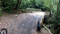
Photos of Heredia Mountain Bike
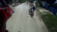
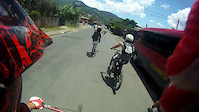
Videos of Heredia Mountain Bike
trail: Duendes
4:31 |
24 |
Mar 15, 2020
trail: Enduro Verde
4:18 |
83 |
Sep 24, 2018
trail: Enduro Verde
0:04 |
33 |
Sep 24, 2018
trail: Duendes
0:05 |
170 |
May 8, 2016

trail: Enduro Verde
0:15 |
278 |
Feb 27, 2015
trail: Duendes
5:35 |
177 |
May 23, 2013
trail: Calle
0:33 |
88 |
Aug 4, 2011
trail: Calle
0:11 |
77 |
Aug 4, 2011
Recent Trail Reports
| status | trail | date | condition | info | user |
|---|---|---|---|---|---|
| Enduro Verde | Dec 8, 2023 @ 8:42pm Dec 8, 2023 | Ideal | fluffdawg33 | ||
| Calle | Oct 11, 2023 @ 4:36am Oct 11, 2023 | Ideal | connorsc | ||
| Parrilla Bros | Oct 11, 2023 @ 4:36am Oct 11, 2023 | Wet | connorsc | ||
| Asequia | Oct 11, 2023 @ 4:36am Oct 11, 2023 | Wet | connorsc | ||
| Venado | Oct 11, 2023 @ 4:36am Oct 11, 2023 | Wet | connorsc | ||
| Subida Potrero | Oct 11, 2023 @ 4:36am Oct 11, 2023 | Variable | connorsc | ||
| Entrada | Oct 11, 2023 @ 4:36am Oct 11, 2023 | Ideal | connorsc | ||
| Muñeco | Jan 3, 2023 @ 8:42am Jan 3, 2023 | Ideal | V1c70r | ||
| Dinosaurios | Jul 17, 2022 @ 12:00pm Jul 17, 2022 | Ideal | V1c70r | ||
| Sendero Picapiedra | Feb 6, 2022 @ 9:10am Feb 6, 2022 | Ideal | V1c70r |
Activity Feed
| username | action | type | title | date |
|---|---|---|---|---|
| tobin | wishlist | region | activity #93641883 | Apr 29, 2026 @ 5:53am Apr 29, 2026 |
| BlairgkrtKo | wishlist | trail | activity #86923198 | Jan 9, 2026 @ 5:09pm Jan 9, 2026 |
| Byron-B | add | report | activity #78299437 | Aug 16, 2025 @ 6:27pm Aug 16, 2025 |
| Ride-VT | wishlist | region | activity #66945606 | Feb 28, 2025 @ 1:37pm Feb 28, 2025 |
| rickvanben | wishlist | region | activity #64157623 | Jan 5, 2025 @ 7:03pm Jan 5, 2025 |
Local Badges
-

Epic Mountain Bike Climb 2k107 awarded -

Climbing 10k Badge38 awarded -

Mountain Biking 100k Badge11 awarded -

Epic Ride Descent 2k107 awarded -

Descent 10k Badge38 awarded -

Descent 100k Badge11 awarded
Bike & Skill Parks
| name | type | city | rating |
|---|---|---|---|
| Adventure Park | bike park | Heredia | |
| Pump Track San Jorge | skill park | Heredia | |
| Pump Track Walmart Plaza | skill park | Heredia | |
| Adventure Park | skill park | Heredia |
Activity Type Stats
| activitytype | trails | distance | descent | descent distance | total vertical | rating | global rank | state rank | photos | reports | routes | ridelogs |
|---|---|---|---|---|---|---|---|---|---|---|---|---|
| Mountain Bike | 14 | 8 miles | 3,671 ft | 6 miles | 738 ft | #1,787 | #3 | 166 | 93 | 1 | 8,461 | |
| E-Bike | 10 | 7 miles | 3,199 ft | 5 miles | 728 ft | #1,296 | #2 | 93 | 104 | |||
| Hike | 8 | 5 miles | 1,555 ft | 3 miles | 2,772 ft | #2,081 | #5 | 92 | 354 | |||
| Trail Running | 12 | 8 miles | 3,553 ft | 6 miles | 2,782 ft | #1,532 | #4 | 93 | 27 |
Frequently Asked Questions About Heredia
▼
What are the best places to ride in Heredia?
Heredia has 1 areas to explore for mountain biking. The top rated areas are:
▼
What are the highest rated mountain biking trails in Heredia?
The highest rated mountain biking trails in Heredia are:
- Parrilla Bros (4.1/5)
- Muñeco (4.1/5)
- Duendes (4.1/5)
- Dinosaurios (4.1/5)
- Enduro Verde (4.1/5)
▼
What is the best time of the year to ride in Heredia?
Based on ride log data, the most popular months to ride in Heredia are:
- August (15 activities)
- May (13 activities)
- April (12 activities)
▼
Where can I park to ride in Heredia?
There are 1 parking locations listed in Heredia. The most popular parking spots are:
Activities
Trails
- By its-chris & contributors
- Admins: castpack
- #4409 - 4,699 views
- heredia activity log | embed map of Heredia mountain bike trails | heredia mountain biking points of interest
Downloading of trail gps tracks in kml & gpx formats is enabled for Heredia.
You must login to download files.