close
-
Layers w
- Weather Layers
- Pro
- Pro
- Pro
- Pro
- Pro
- Pro
- More Layers
- Pro
- Pro
- Pro
- Pro
-
Upgrade to

3D
Trail Conditions
- Unknown
- Snow Groomed
- Snow Packed
- Snow Covered
- Snow Cover Partial
- Freeze/thaw Cycle
- Icy
- Prevalent Mud
- Wet
- Variable
- Ideal
- Dry
- Very Dry
Trail Flow (Ridden Direction)
Trailforks scans users ridelogs to determine the most popular direction each trail is ridden. A good flowing trail network will have most trails flowing in a single direction according to their intension.
The colour categories are based on what percentage of riders are riding a trail in its intended direction.
The colour categories are based on what percentage of riders are riding a trail in its intended direction.
- > 96%
- > 90%
- > 80%
- > 70%
- > 50%
- < 50%
- bi-directional trail
- no data
Trail Last Ridden
Trailforks scans ridelogs to determine the last time a trail was ridden.
- < 2 days
- < 1 week
- < 2 weeks
- < 1 month
- < 6 months
- > 6 months
Trail Ridden Direction
The intended direction a trail should be ridden.
- Downhill Only
- Downhill Primary
- Both Directions
- Uphill Primary
- Uphill Only
- One Direction
Contribute Details
Colors indicate trail is missing specified detail.
- Description
- Photos
- Description & Photos
- Videos
Trail Popularity ?
Trailforks scans ridelogs to determine which trails are ridden the most in the last 9 months.
Trails are compared with nearby trails in the same city region with a possible 25 colour shades.
Think of this as a heatmap, more rides = more kinetic energy = warmer colors.
- most popular
- popular
- less popular
- not popular
ATV/ORV/OHV Filter
Max Vehicle Width
inches
US Cell Coverage
Legend

Radar Time
Activity Recordings
Trailforks uses anonymized public activity data.
?
Activity Recordings
Trailforks uses anonymized public activity data.
?
Personal Heatmap
▶
Activity Types
all
/
none
▶
Options
2
Date range
month
–
Winter Trails
Warning
A routing network for winter maps does not exist. Selecting trails using the winter trails layer has been disabled.
Missing Trails
Most Popular
Least Popular
Trails are colored based on popularity. The more popular a trail is, the more red. Less popular trails trend towards green.
Jump Magnitude Heatmap
Heatmap of where riders jump on trails. Zoom in to see individual jumps, click circles to view jump details.
BC Backroad Status
![map legend]()
Service Road Atlas is a free to use, community-driven service for viewing and creating reports on the numerous back-country service roads around B.C. and Alberta.

Slope Aspect
Direction the slope faces
Trails Deemphasized
Trails are shown in grey.
Only show trails with no bike usage.
Suggested Layers
Based on selected activity type
Save the current map location and zoom level as your default home location whenever this page is loaded.
Save
No description for Herefordshire has been added yet!
Login or register to submit one.
This region uses the Uk/Euro style trail grading system.
Activities Click to view
- Mountain Bike
17 trails
- E-Bike
14 trails
- Horse
4 trails
- Hike
8 trails
- Trail Running
8 trails
Region Details
- 7
- 5
- 2
- 3
Stats
- Avg Trail Rating
- Trails (view details)
- 17
- Trails Mountain Bike
- 17
- Trails E-Bike
- 14
- Trails Horse
- 4
- Trails Hike
- 8
- Trails Trail Running
- 8
- Total Distance
- 12 miles
- Total Descent Distance
- 7 miles
- Total Descent
- 3,418 ft
- Total Vertical
- 552 ft
- Highest Trailhead
- 947 ft
- Reports
- 18
- Photos
- 9
- Ridden Counter
- 434
Articles
Malverns Classic 2019 Cancelled After Heavy Rainfall
Jun 13, 2019 from pinkbike.com
Due to heavy rain and despite their team doing the best they can to mitigate its effects, the decision has been made to cancel the event on health...
Sub Regions
- Wigmore (13)
- Wigmore Rolls (13)
Popular Herefordshire Mountain Biking Trails
• 100 ★ 0.0 • 2,644 ft • 0 ft • 96 •
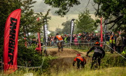
The Schwalbe Downhill At The Malverns Classic
• 40 ★ 3.0 • 3,612 ft • 0 ft • 84 •
Stage 1 of the Enduro race at the 2021 Malverns Classic.
• ★ 0.0 • 2,815 ft • 0 ft • 73 •
Stage 4 of the Enduro race at the Malverns Classic
• 80 ★ 0.0 • 3,343 ft • 11 ft • 64 •
Stage 2 of the Enduro race at the 2021 Malverns Classic.
• 5 ★ 0.0 • 659 ft • 0 ft • 4 •
Turn L off the fire road from the pond at the turn R.It's all loamy goodness from there
• 5 ★ 1.0 • 787 ft • 0 ft • 2 •
Turn off the at the bend after the fallen tree. The 'Brown' is unrelentingly steep loam and hard packed dirt, all the way from the ridge to the bottom track.
• 5 ★ 0.0 • 948 ft • 0 ft • 1 •
Turn L off the ridge track, then after 50m turn L off the Shropshire Brown. Follow the trail to he obvious large flat track, turn R just before the gully, down the steep chute, join the gully, through the narrows and then turn L at the...
Videos of Herefordshire Mountain Bike
0:47 |
32 |
Feb 25, 2025
Recent Trail Reports
| status | trail | date | condition | info | user |
|---|---|---|---|---|---|
| Al Gorse Wigmore Rolls | Feb 23, 2026 @ 5:45pm (Europe/London) Feb 23, 2026 | Ideal | NoahJones1 | ||
| The Malverns Classic Funnduro Stage 1 Ledbury | Aug 24, 2025 @ 11:27am Aug 24, 2025 | Dry | joeg885 | ||
| The Malverns Classic Funnduro Stage 4 Herefordshire | Aug 26, 2022 @ 4:08am Aug 26, 2022 | Unknown | Mtbtrailrider70 | ||
| The Malverns Classic The Schwalbe Downhill Ledbury | Aug 26, 2022 @ 4:08am Aug 26, 2022 | Ideal | Mtbtrailrider70 |
Activity Feed
| username | action | type | title | date |
|---|---|---|---|---|
| tvt1 | ridden | trail | activity #93136074 and 1 more | Apr 22, 2026 @ 2:43am Apr 22, 2026 |
| NoahJones1 | add | report | activity #89419142 | Feb 23, 2026 @ 9:45am Feb 23, 2026 |
| Bluesurfweasel | wishlist | trail | activity #82712726 | Oct 20, 2025 @ 8:33am Oct 20, 2025 |
| NoahJones1 | ridden | trail | activity #81622726 | Oct 3, 2025 @ 12:54pm Oct 3, 2025 |
| JoeP89 | ridden | trail | activity #80882490 | Sep 22, 2025 @ 1:59am Sep 22, 2025 |
Recent Comments
| username | type | title | comment | date |
|---|---|---|---|---|
| report | Good trail ridable | Aug 27, 2025 @ 1:16pm Aug 27, 2025 |
Local Badges
-

Epic Mountain Bike Climb 2k3 awarded -

Climbing 10k Badge2 awarded -

Mountain Biking 100k Badge0 awarded -

Epic Ride Descent 2k3 awarded -

Descent 10k Badge2 awarded -

Descent 100k Badge0 awarded
Activity Type Stats
| activitytype | trails | distance | descent | descent distance | total vertical | rating | global rank | state rank | photos | reports | routes | ridelogs |
|---|---|---|---|---|---|---|---|---|---|---|---|---|
| Mountain Bike | 17 | 12 miles | 3,419 ft | 7 miles | 551 ft | 9 | 18 | 1,883 | ||||
| E-Bike | 14 | 10 miles | 2,602 ft | 6 miles | 551 ft | 17 | 156 | |||||
| Horse | 4 | 5 miles | 689 ft | 2 miles | 433 ft | 4 | ||||||
| Hike | 8 | 9 miles | 1,302 ft | 4 miles | 433 ft | 12 | 63 | |||||
| Trail Running | 8 | 9 miles | 1,302 ft | 4 miles | 433 ft | 12 | 29 |
Frequently Asked Questions About Herefordshire
▼
What are the best places to ride in Herefordshire?
Herefordshire has 1 areas to explore for mountain biking. The top rated areas are:
▼
What are the highest rated mountain biking trails in Herefordshire?
The highest rated mountain biking trails in Herefordshire are:
- A Large Shropshire Brown (3.2/5)
- The Malverns Classic The Schwalbe Downhill (0/5)
- Al Gorse (0/5)
- The Malverns Classic Funnduro Stage 2 (0/5)
- The Malverns Classic Funnduro Stage 1 (0/5)
▼
What is the best time of the year to ride in Herefordshire?
Based on ride log data, the most popular months to ride in Herefordshire are:
- August (6 activities)
- September (5 activities)
- March (4 activities)
▼
What is the longest trail in Herefordshire?
The longest trail in Herefordshire is Ridge Track at 1.3 miles. View all trails sorted by distance.
Activities
Trails
Points of Interest
- By brenthillier
 NSMBA TRAILFORKS & contributors
 - Admins: UKTP, 20twenty-p, wisey, MathieuC, cemoorelife
- #6839 - 5,665 views
- herefordshire activity log | embed map of Herefordshire mountain bike trails | herefordshire mountain biking points of interest
Downloading of trail gps tracks in kml & gpx formats is enabled for Herefordshire.
You must login to download files.