close
-
Layers w
- Weather Layers
- Pro
- Pro
- Pro
- Pro
- Pro
- Pro
- More Layers
- Pro
- Pro
- Pro
- Pro
-
Upgrade to

3D
Trail Conditions
- Unknown
- Snow Groomed
- Snow Packed
- Snow Covered
- Snow Cover Partial
- Freeze/thaw Cycle
- Icy
- Prevalent Mud
- Wet
- Variable
- Ideal
- Dry
- Very Dry
Trail Flow (Ridden Direction)
Trailforks scans users ridelogs to determine the most popular direction each trail is ridden. A good flowing trail network will have most trails flowing in a single direction according to their intension.
The colour categories are based on what percentage of riders are riding a trail in its intended direction.
The colour categories are based on what percentage of riders are riding a trail in its intended direction.
- > 96%
- > 90%
- > 80%
- > 70%
- > 50%
- < 50%
- bi-directional trail
- no data
Trail Last Ridden
Trailforks scans ridelogs to determine the last time a trail was ridden.
- < 2 days
- < 1 week
- < 2 weeks
- < 1 month
- < 6 months
- > 6 months
Trail Ridden Direction
The intended direction a trail should be ridden.
- Downhill Only
- Downhill Primary
- Both Directions
- Uphill Primary
- Uphill Only
- One Direction
Contribute Details
Colors indicate trail is missing specified detail.
- Description
- Photos
- Description & Photos
- Videos
Trail Popularity ?
Trailforks scans ridelogs to determine which trails are ridden the most in the last 9 months.
Trails are compared with nearby trails in the same city region with a possible 25 colour shades.
Think of this as a heatmap, more rides = more kinetic energy = warmer colors.
- most popular
- popular
- less popular
- not popular
ATV/ORV/OHV Filter
Max Vehicle Width
inches
US Cell Coverage
Legend

Radar Time
Activity Recordings
Trailforks uses anonymized public activity data.
?
Activity Recordings
Trailforks uses anonymized public activity data.
?
Personal Heatmap
▶
Activity Types
all
/
none
▶
Options
2
Date range
month
–
Winter Trails
Warning
A routing network for winter maps does not exist. Selecting trails using the winter trails layer has been disabled.
Missing Trails
Most Popular
Least Popular
Trails are colored based on popularity. The more popular a trail is, the more red. Less popular trails trend towards green.
Jump Magnitude Heatmap
Heatmap of where riders jump on trails. Zoom in to see individual jumps, click circles to view jump details.
BC Backroad Status
![map legend]()
Service Road Atlas is a free to use, community-driven service for viewing and creating reports on the numerous back-country service roads around B.C. and Alberta.

Slope Aspect
Direction the slope faces
Trails Deemphasized
Trails are shown in grey.
Only show trails with no bike usage.
Suggested Layers
Based on selected activity type
Save the current map location and zoom level as your default home location whenever this page is loaded.
SaveThis region is Unsanctioned, Ride at your own Risk!
Situated to the west of the A9 and the town of Aviemore, High Burnside is littered with fantastic, hand built trails.
Primary Trail Type: All-Mountain & Downhill
Land Status: Private Managed Forest
Land Manager: Seafield and Strathspey Estates
This region uses the Uk/Euro style trail grading system.
Activities Click to view
- Mountain Bike
65 trails
- E-Bike
59 trails
- Hike
65 trails
- Trail Running
65 trails
Region Details
- 23
- 2
- 6
- 20
- 11
- 3
Region Status
Open as of Jun 23, 2026Stats
- Avg Trail Rating
- Trails (view details)
- 65
- Trails Mountain Bike
- 65
- Trails E-Bike
- 59
- Trails Horse
- 1
- Trails Hike
- 65
- Trails Trail Running
- 65
- Total Distance
- 27 miles
- Total Descent
- 7,778 ft
- Total Vertical
- 980 ft
- Highest Trailhead
- 1,664 ft
- Reports
- 757
- Photos
- 68
- Ridden Counter
- 18,140
Popular High Burnside Mountain Biking Trails
• 100 ★ 4.6 • 2,175 ft • 109 ft • 703 •
Highly rated popular red difficulty singletrack. This mountain bike primary trail can be used uphill primary and has a moderate overall physical rating with a 109 ft blue climb. On average it takes 7 minutes to complete this trail.
• 95 ★ 4.2 • 1,407 ft • 0 ft • 630 •
Highly rated popular black difficulty singletrack. This mountain bike primary trail can be used downhill primary and has a moderate overall physical rating with a 0 ft blue climb. Trail visibility is always easy to follow. On average it takes 7 minutes to complete this trail.
• 95 ★ 4.3 • 1,496 ft • 0 ft • 621 •
Highly rated popular black difficulty singletrack. This mountain bike primary trail can be used downhill primary and has a moderate overall physical rating with a 0 ft blue climb. Trail visibility is always easy to follow. On average it takes 3 minutes to complete this trail.
• 100 ★ 3.4 • 2,382 ft • 20 ft • 534 •
Popular red difficulty singletrack. This mountain bike primary trail can be used one direction and has a moderate overall physical rating with a 20 ft blue climb. Trail visibility is always easy to follow. On average it takes 5 minutes to complete this trail.
• 90 ★ 4.0 • 3,376 ft • 0 ft • 515 •
Highly rated popular black difficulty singletrack. This mountain bike primary trail can be used downhill primary and has a moderate overall physical rating with a 0 ft blue climb. Trail visibility is always easy to follow. On average it takes 5 minutes to complete this trail.
• 80 ★ 3.5 • 1,401 ft • 14 ft • 473 •
Popular blue difficulty singletrack. This mountain bike primary trail can be used one direction and has a moderate overall physical rating with a 14 ft blue climb. On average it takes 2 minutes to complete this trail.
• 90 ★ 3.6 • 1,411 ft • 0 ft • 460 •
Originally designed as a climb this is a nice flowy trail jumping from .
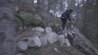
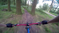
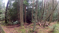
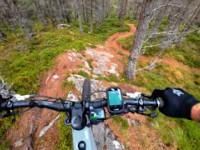
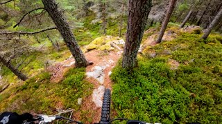
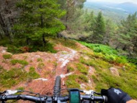
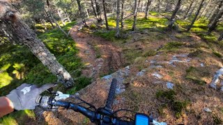
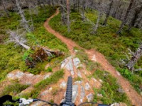
Photos of High Burnside Mountain Bike
Videos of High Burnside Mountain Bike
trail: Intellectual Property
0:00 |
1394 |
Aug 21, 2019
trail: Top Trail
5:57 |
237 |
Sep 5, 2015
trail: Intellectual Property
0:32 |
1107 |
Feb 4, 2013
trail: Intellectual Property
2:08 |
148 |
Aug 18, 2025 , Aviemore
trail: Bridge To Nowhere
3:12 |
69 |
Aug 18, 2025 , Aviemore
trail: Dangermouse
0:55 |
87 |
Aug 18, 2025 , Aviemore
trail: Antidote
2:59 |
156 |
Aug 18, 2025 , Aviemore
trail: Side Pipe
2:30 |
65 |
Aug 18, 2025 , Aviemore
Recent Trail Reports
| status | trail | date | condition | info | user |
|---|---|---|---|---|---|
| Christ Almighty | Jun 23, 2026 @ 11:49am (Europe/London) Jun 23, 2026 | Ideal | turnertower | ||
| Lefticle | Jun 23, 2026 @ 11:49am (Europe/London) Jun 23, 2026 | Ideal | turnertower | ||
| Forest Road | Jun 17, 2026 @ 6:50pm (Europe/Isle_of_Man) Jun 17, 2026 | Ideal | tononinjaman | ||
| Richards Down | Jun 17, 2026 @ 6:50pm (Europe/Isle_of_Man) Jun 17, 2026 | Ideal | tononinjaman | ||
| Antidote | Jun 17, 2026 @ 6:50pm (Europe/Isle_of_Man) Jun 17, 2026 | Ideal | tononinjaman | ||
| Antidote Access | Jun 17, 2026 @ 6:50pm (Europe/Isle_of_Man) Jun 17, 2026 | Ideal | tononinjaman | ||
| Trans Burnside Express | Jun 17, 2026 @ 6:50pm (Europe/Isle_of_Man) Jun 17, 2026 | Ideal | tononinjaman | ||
| Cut Ya Bars | Jun 17, 2026 @ 6:50pm (Europe/Isle_of_Man) Jun 17, 2026 | Ideal | tononinjaman | ||
| Side Pipe | Jun 17, 2026 @ 6:50pm (Europe/Isle_of_Man) Jun 17, 2026 | Ideal | tononinjaman | ||
| Intellectual Property | Jun 17, 2026 @ 6:50pm (Europe/Isle_of_Man) Jun 17, 2026 | Ideal | tononinjaman |
Activity Feed
| username | action | type | title | date |
|---|---|---|---|---|
| turnertower | add | report | activity #97615806 and 1 more | Jun 23, 2026 @ 3:49am Jun 23, 2026 |
| tononinjaman | add | report | activity #97243600 and 17 more | Jun 18, 2026 @ 4:51am Jun 18, 2026 |
| mariusnoller | ridden | trail | activity #95787157 and 1 more | May 29, 2026 @ 10:24am May 29, 2026 |
| RobbieRTpckW | ridden | trail | activity #95784729 | May 29, 2026 @ 9:50am May 29, 2026 |
| turnertower | add | report | activity #95719023 | May 28, 2026 @ 10:51am May 28, 2026 |
Recent Comments
| username | type | title | comment | date |
|---|---|---|---|---|
| report | F CD o CD | May 26, 2026 @ 6:41am May 26, 2026 | ||
| report | Red | May 26, 2026 @ 6:41am May 26, 2026 | ||
| trail | Still tape across entry | Oct 31, 2025 @ 6:27am Oct 31, 2025 | ||
| trail | Amazing trail! Really enjoyed all the rock slabs. | Oct 5, 2025 @ 10:37am Oct 5, 2025 | ||
| trail | Brilliant trail! Really enjoyed it but glad i... | Oct 5, 2025 @ 10:35am Oct 5, 2025 |
Nearby Areas
| name | distance | ||||
|---|---|---|---|---|---|
| Carrbridge | 2 | 8 | 2.3 km | ||
| Boat of Garten | 3 | 2.4 km | |||
| Sender Bike Park | 4 | 5 | 2.8 km | ||
| Badaguish | 4.7 km | ||||
| Inshriach and Dalnavert | 7 | 5.5 km |
Local Badges
-

Completionist0 awarded
Activity Type Stats
| activitytype | trails | distance | descent | descent distance | total vertical | rating | global rank | state rank | photos | reports | routes | ridelogs |
|---|---|---|---|---|---|---|---|---|---|---|---|---|
| Mountain Bike | 65 | 27 miles | 7,779 ft | 17 miles | 981 ft | #1,427 | #53 | 68 | 757 | 3,905 | ||
| E-Bike | 59 | 14 miles | 4,869 ft | 8 miles | 948 ft | #2,500 | #87 | 697 | 895 | |||
| Horse | 1 | 2 miles | 85 ft | 4,127 ft | 85 ft | 108 | ||||||
| Hike | 65 | 27 miles | 7,779 ft | 17 miles | 981 ft | #4,141 | #70 | 736 | 315 | |||
| Trail Running | 65 | 27 miles | 7,779 ft | 17 miles | 981 ft | #3,324 | #66 | 736 | 188 |
Frequently Asked Questions About High Burnside
▼
What are the highest rated mountain biking trails in High Burnside?
The highest rated mountain biking trails in High Burnside are:
- Nazi Gold (4.5/5)
- Antidote (4.4/5)
- Skull Trail (4.4/5)
- Lefticle (4.3/5)
- Side Pipe (4.3/5)
▼
What is the best time of the year to ride in High Burnside?
Based on ride log data, the most popular months to ride in High Burnside are:
- July (61 activities)
- August (31 activities)
- May (24 activities)
▼
Where can I park to ride in High Burnside?
Check the High Burnside trail map for trailhead and parking information. Community members regularly update access and parking details for trails in the area.
▼
What is the longest trail in High Burnside?
The longest trail in High Burnside is Nazi Gold at 1.2 km. View all trails sorted by distance.
Activities
- By gav-s
 & contributors
 - Admins: LTA, BSTA
- #12555 - 26,887 views
- high burnside activity log | embed map of High Burnside mountain bike trails |
Downloading of trail gps tracks in kml & gpx formats is enabled for High Burnside.
You must login to download files.