close
-
Layers w
- Weather Layers
- Pro
- Pro
- Pro
- Pro
- Pro
- Pro
- More Layers
- Pro
- Pro
- Pro
- Pro
-
Upgrade to

3D
Trail Conditions
- Unknown
- Snow Groomed
- Snow Packed
- Snow Covered
- Snow Cover Partial
- Freeze/thaw Cycle
- Icy
- Prevalent Mud
- Wet
- Variable
- Ideal
- Dry
- Very Dry
Trail Flow (Ridden Direction)
Trailforks scans users ridelogs to determine the most popular direction each trail is ridden. A good flowing trail network will have most trails flowing in a single direction according to their intension.
The colour categories are based on what percentage of riders are riding a trail in its intended direction.
The colour categories are based on what percentage of riders are riding a trail in its intended direction.
- > 96%
- > 90%
- > 80%
- > 70%
- > 50%
- < 50%
- bi-directional trail
- no data
Trail Last Ridden
Trailforks scans ridelogs to determine the last time a trail was ridden.
- < 2 days
- < 1 week
- < 2 weeks
- < 1 month
- < 6 months
- > 6 months
Trail Ridden Direction
The intended direction a trail should be ridden.
- Downhill Only
- Downhill Primary
- Both Directions
- Uphill Primary
- Uphill Only
- One Direction
Contribute Details
Colors indicate trail is missing specified detail.
- Description
- Photos
- Description & Photos
- Videos
Trail Popularity ?
Trailforks scans ridelogs to determine which trails are ridden the most in the last 9 months.
Trails are compared with nearby trails in the same city region with a possible 25 colour shades.
Think of this as a heatmap, more rides = more kinetic energy = warmer colors.
- most popular
- popular
- less popular
- not popular
ATV/ORV/OHV Filter
Max Vehicle Width
inches
US Cell Coverage
Legend

Radar Time
Activity Recordings
Trailforks uses anonymized public activity data.
?
Activity Recordings
Trailforks uses anonymized public activity data.
?
Personal Heatmap
▶
Activity Types
all
/
none
▶
Options
2
Date range
month
–
Winter Trails
Warning
A routing network for winter maps does not exist. Selecting trails using the winter trails layer has been disabled.
Missing Trails
Most Popular
Least Popular
Trails are colored based on popularity. The more popular a trail is, the more red. Less popular trails trend towards green.
Jump Magnitude Heatmap
Heatmap of where riders jump on trails. Zoom in to see individual jumps, click circles to view jump details.
BC Backroad Status
![map legend]()
Service Road Atlas is a free to use, community-driven service for viewing and creating reports on the numerous back-country service roads around B.C. and Alberta.

Slope Aspect
Direction the slope faces
Trails Deemphasized
Trails are shown in grey.
Only show trails with no bike usage.
Suggested Layers
Based on selected activity type
Save the current map location and zoom level as your default home location whenever this page is loaded.
Save
No description for Hinckley has been added yet!
Login or register to submit one.
Activities Click to view
- Hike
98 trails
- Mountain Bike
48 trails
- E-Bike
0 trails
- Adaptive Bike
- Horse
61 trails
- Trail Running
98 trails
- Snowmobile
57 trails
- Snowshoe
12 trails
- Nordic Ski
41 trails
Region Details
- 5
- 1
- 12
- 1
Region Status
Open as of Aug 23, 2025Stats
- Trails (view details)
- 41
- Trails Mountain Bike
- 48
- Trails Horse
- 61
- Trails Hike
- 98
- Trails Trail Running
- 98
- Trails ATV/ORV/OHV
- 1
- Trails Snowmobile
- 57
- Trails Snowshoe
- 12
- Trails Nordic Ski
- 41
- Total Distance
- 67 miles
- Total Descent Distance
- 26 miles
- Total Descent
- 1,179 ft
- Total Vertical
- 300 ft
- Highest Trailhead
- 1,133 ft
- Reports
- 6
- Photos
- 4
- Ridden Counter
- 319
Articles
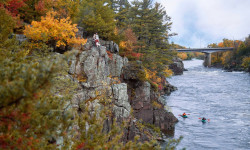
Minnesota’s Most Spectacular Hikes
Aug 23, 2021 from backpacker.com
Experience the beauty of fall foliage in Minnesota with these bucket list hikes
Sub Regions
-
St. Croix State Park
- 12
- 1
Popular Hinckley Mountain Biking Trails
• 75 ★ 0.0 • 32 miles • 141 ft • 26 •
This 70 mile segment of the Willard Munger State Trail is completely paved. The trail passes near Banning State Park and Moose Lake State Park. It passes through the towns of Finlayson, Willow River, Moose Lake, General C.C. Andrews...
• 100 ★ 0.0 • 945 ft • 36 ft • 16 • • hike
Popular green difficulty singletrack. This hike primary trail can be used both directions. On average it takes 1 minutes to complete this trail.
• 80 ★ 0.0 • 1,060 ft • 0 ft • 10 •
Popular white difficulty paved path. This multi-use trail can be used both directions. On average it takes 1 minutes to complete this trail.
• 90 ★ 0.0 • 3 miles • 8 ft • 9 •
Popular white difficulty paved path. This multi-use trail can be used both directions. Adaptive MTB rating: amtb green. On average it takes 30 minutes to complete this trail.
• 85 ★ 0.0 • 571 ft • 0 ft • 6 •
Popular white difficulty paved path. This multi-use trail can be used both directions. On average it takes minutes to complete this trail.
• 95 ★ 0.0 • 2 miles • 10 ft • 6 •
This section of the paved trail is packed for snowshoe and fatbike use in the winter
• 5 ★ 0.0 • 2 miles • 6 ft • 5 •
Less popular green difficulty singletrack. This multi-use trail can be used both directions.
• 65 ★ 0.0 • 6 miles • 94 ft • 5 •
Moderately popular green difficulty mixed. This multi-use trail can be used both directions.
Recent Trail Reports
no previous reports, add one now!
Activity Feed
| username | action | type | title | date |
|---|---|---|---|---|
| eyelike2bike | wishlist | trail | activity #97101476 | Jun 16, 2026 @ 5:14am Jun 16, 2026 |
| nunnu | wishlist | trail | activity #93139150 | Apr 22, 2026 @ 4:29am Apr 22, 2026 |
| GWhittleAL | wishlist | trail | activity #80420354 | Sep 15, 2025 @ 12:17pm Sep 15, 2025 |
| evanjpak | add | report | activity #78877597 | Aug 24, 2025 @ 3:21pm Aug 24, 2025 |
| KevinKN2vin | add | poi | activity #76634942 and 3 more | Jul 24, 2025 @ 5:39pm Jul 24, 2025 |
Local Badges
-

Completionist0 awarded -

10 Green Trails0 awarded -

Epic Mountain Bike Climb 2k0 awarded -

Climbing 10k Badge0 awarded -

Mountain Biking 100k Badge0 awarded -

Epic Ride Descent 2k0 awarded
Activity Type Stats
| activitytype | trails | distance | descent | descent distance | total vertical | rating | global rank | state rank | photos | reports | routes | ridelogs |
|---|---|---|---|---|---|---|---|---|---|---|---|---|
| Mountain Bike | 48 | 46 miles | 417 ft | 20 miles | 249 ft | #12,096 | #3,726 | 2 | 6 | 539 | ||
| Horse | 61 | 14 miles | 207 ft | 3 miles | 102 ft | #1,885 | #1,057 | |||||
| Hike | 98 | 67 miles | 1,178 ft | 26 miles | 302 ft | #3,628 | #1,278 | 2 | 6 | 3 | 131 | |
| Trail Running | 98 | 67 miles | 1,178 ft | 26 miles | 302 ft | #3,326 | #977 | 6 | 1 | 16 | ||
| ATV/ORV/OHV | 1 | |||||||||||
| Snowmobile | 57 | #383 | #202 | |||||||||
| Snowshoe | 12 | 11 miles | 499 ft | 4 miles | 154 ft | #1,411 | #785 | 2 | ||||
| Nordic Ski | 41 | #1,555 | #766 | 4 |
Frequently Asked Questions About Hinckley
▼
What are the best places to ride in Hinckley?
Hinckley has 2 areas to explore for mountain biking. The top rated areas are:
▼
What are the highest rated mountain biking trails in Hinckley?
The highest rated mountain biking trails in Hinckley are:
- Crooked Creek Loop Access (0/5)
- Paved Multi-Use Path (0/5)
- Paved Multi-Use Path (West) (0/5)
- Paved Connector (0/5)
- Willard Munger State Trail (0/5)
▼
What is the best time of the year to ride in Hinckley?
Based on ride log data, the most popular months to ride in Hinckley are:
- June (2 activities)
- May (1 activities)
- September (1 activities)
▼
Where can I park to ride in Hinckley?
Activities
Trails
Points of Interest
- Crooked Creek Camp Camping
- Two Rivers Campsite Camping
- Pine Ridge Campsite Camping
- Kettle River Overlook Viewpoint
- Kettle River overlook Viewpoint
- Lake Clayton Beach Picnic Area Sight
- Paint Rock Springs Campground Camping
- Old Logging Trail Campground Camping
- Riverview Campground Camping
- Banning State Park Campground Camping
- By markholloway
 Trailforks Map Team & contributors
 - Admins: MW HIKING, namdoogttam, Redpine, CycleKrieg, mnmtb
- #47512 - 1,030 views
- hinckley activity log | embed map of Hinckley mountain bike trails | hinckley mountain biking points of interest
Downloading of trail gps tracks in kml & gpx formats is enabled for Hinckley.
You must login to download files.