close
-
Layers w
- Weather Layers
- Pro
- Pro
- Pro
- Pro
- Pro
- Pro
- More Layers
- Pro
- Pro
- Pro
- Pro
-
Upgrade to

3D
Trail Conditions
- Unknown
- Snow Groomed
- Snow Packed
- Snow Covered
- Snow Cover Partial
- Freeze/thaw Cycle
- Icy
- Prevalent Mud
- Wet
- Variable
- Ideal
- Dry
- Very Dry
Trail Flow (Ridden Direction)
Trailforks scans users ridelogs to determine the most popular direction each trail is ridden. A good flowing trail network will have most trails flowing in a single direction according to their intension.
The colour categories are based on what percentage of riders are riding a trail in its intended direction.
The colour categories are based on what percentage of riders are riding a trail in its intended direction.
- > 96%
- > 90%
- > 80%
- > 70%
- > 50%
- < 50%
- bi-directional trail
- no data
Trail Last Ridden
Trailforks scans ridelogs to determine the last time a trail was ridden.
- < 2 days
- < 1 week
- < 2 weeks
- < 1 month
- < 6 months
- > 6 months
Trail Ridden Direction
The intended direction a trail should be ridden.
- Downhill Only
- Downhill Primary
- Both Directions
- Uphill Primary
- Uphill Only
- One Direction
Contribute Details
Colors indicate trail is missing specified detail.
- Description
- Photos
- Description & Photos
- Videos
Trail Popularity ?
Trailforks scans ridelogs to determine which trails are ridden the most in the last 9 months.
Trails are compared with nearby trails in the same city region with a possible 25 colour shades.
Think of this as a heatmap, more rides = more kinetic energy = warmer colors.
- most popular
- popular
- less popular
- not popular
ATV/ORV/OHV Filter
Max Vehicle Width
inches
US Cell Coverage
Legend

Radar Time
Activity Recordings
Trailforks uses anonymized public activity data.
?
Activity Recordings
Trailforks uses anonymized public activity data.
?
Personal Heatmap
▶
Activity Types
all
/
none
▶
Options
2
Date range
month
–
Winter Trails
Warning
A routing network for winter maps does not exist. Selecting trails using the winter trails layer has been disabled.
Missing Trails
Most Popular
Least Popular
Trails are colored based on popularity. The more popular a trail is, the more red. Less popular trails trend towards green.
Jump Magnitude Heatmap
Heatmap of where riders jump on trails. Zoom in to see individual jumps, click circles to view jump details.
BC Backroad Status
![map legend]()
Service Road Atlas is a free to use, community-driven service for viewing and creating reports on the numerous back-country service roads around B.C. and Alberta.

Slope Aspect
Direction the slope faces
Trails Deemphasized
Trails are shown in grey.
Only show trails with no bike usage.
Suggested Layers
Based on selected activity type
Save the current map location and zoom level as your default home location whenever this page is loaded.
SaveNote: Being listed on Trailforks is not an indication of trail legality or permitted use. Follow all landowner directions and do not build trails without landowner permission.
Hobart is located on the estuary of the Derwent River in the state's south-east. Geologically Hobart is built predominantly on Jurassic dolerite around the foothills interspersed with smaller areas of Triassic siltstone and Permian mudstone. Hobart extends along both sides of the Derwent River; on the western shore from the Derwent valley in the north through the flatter areas of Glenorchy which rests on older Triassic sediment and into the hilly areas of New Town, Lenah Valley. Both of these areas rest on the younger Jurassic dolerite deposits, before stretching into the lower areas such as the beaches of Sandy Bay in the south, in the Derwent estuary. South of the Derwent estuary lies Storm Bay and the Tasman Peninsula.
The Eastern Shore also extends from the Derwent valley area in a southerly direction hugging the Meehan Range in the east before sprawling into flatter land in suburbs such as Bellerive. These flatter areas of the eastern shore rest on far younger deposits from the Quaternary. From there the city extends in an easterly direction through the Meehan Range into the hilly areas of Rokeby and Oakdowns, before reaching into the tidal flatland area of Lauderdale.
Hobart has access to a number of beach areas including those in the Derwent estuary itself; Sandy Bay, Cornelian Bay, Nutgrove, Kingston, Bellerive, and Howrah Beaches as well as many more in Frederick Henry Bay such as; Seven Mile, Roaches, Cremorne, Clifton, and Goats Beaches.
source: Wikipedia
Links
Activities Click to view
- Mountain Bike
593 trails
- E-Bike
602 trails
- Gravel Bike
1 trails
- Adaptive Bike
0 trails
- Winter Fat Bike
0 trails
- Horse
18 trails
- Hike
540 trails
- Trail Running
538 trails
- Dirtbike/Moto
5 trails
- ATV/ORV/OHV
6 trails
Region Details
- 127
- 11
- 141
- 209
- 65
- 11
Region Status
Open as of 1 dayStats
- Avg Trail Rating
- Trails (view details)
- 631
- Trails Mountain Bike
- 596
- Trails E-Bike
- 602
- Trails Gravel Bike
- 1
- Trails Horse
- 18
- Trails Hike
- 540
- Trails Trail Running
- 538
- Trails Dirtbike/Moto
- 5
- Trails Observed Trials
- 1
- Trails ATV/ORV/OHV
- 6
- Total Distance
- 486 miles
- Total Descent
- 111,764 ft
- Total Vertical
- 4,503 ft
- Highest Trailhead
- 4,506 ft
- Reports
- 4,333
- Photos
- 877
- Ridden Counter
- 106,624
Sub Regions
-
Bayview Road Network - Tasman Peninsula Mountain Bike Trails
- 4
- 9
- 5
-
Cascades (South Hobart)
- 3
- 21
- 16
- 3
-
Geilston Bay
- 9
- 10
- 4
-
Glenorchy Mountain Bike Park
- 6
- 6
- 3
- 1
-
Kellevie
- 3
- 6
-
Kellevie MTB Park
-
Knocklofty Reserve
- 5
- 18
- 2
-
Kunanyi / Mount Wellington
- 5
- 17
- 4
-
Lenah Valley
- 2
- 3
- 2
- 2
-
Maria Island
-
McRobies Gully
- 1
-
Meadowbank MTB
- 6
- 1
- 1
-
Meehan Range
- 1
- 26
- 42
- 7
- 1
-
Mount Nelson
- 12
- 20
- 6
- 1
-
Pilcher
- 6
- 7
- 1
-
Queens Domain
- 2
- 6
- 10
-
Ridgeway Park
- 1
- 10
- 16
- 3
-
Single Hill
- 3
-
Tangara Trail
- 2
- 10
- 4
-
Tranmere Hills
- 1
- 11
- 5
- 3
-
Waverley Flora Reserve
- 2
- 5
- 2
Popular Hobart Mountain Biking Trails
• 100 ★ 3.7 • 4,423 ft • 254 ft • 920 •
An easy and pleasant climbing trail out of the MTB Park and west towards (connector to the ), XC Descent and the Belbins Road area of the Meehan Range trail network.
• 95 ★ 4.4 • 2,470 ft • 11 ft • 892 •
Highly rated popular blue difficulty singletrack. This mountain bike primary trail and has a easy overall physical rating. Trail visibility is always easy to follow. On average it takes 1 minutes to complete this trail.
• 100 ★ 4.2 • 1,503 ft • 0 ft • 884 •
A beginner's jump line that allows novice riders to keep their wheels on the dirt if they choose to.
C5 Permanently Closed
• 100 ★ 3.0 • 1,175 ft • 37 ft • 880 •
Popular blue difficulty closed singletrack. This mountain bike primary trail can be used downhill primary and has a moderate overall physical rating. It features jump. On average it takes 1 minutes to complete this trail.
C4 Permanently Closed
• 100 ★ 3.4 • 643 ft • 4 ft • 860 •
Popular blue difficulty closed singletrack. This mountain bike primary trail can be used downhill primary and has a easy overall physical rating. It features berm. On average it takes minutes to complete this trail.
• 75 ★ 4.7 • 6 miles • 412 ft • 826 •
This purpose built shared-use track in Wellington Park linking The Springs with the Glenorchy Mountain Bike Park is an interesting and appealing track for both mountain bike riders and walkers. The track was completed in December 2011...
• 100 ★ 4.6 • 4,399 ft • 354 ft • 804 •
A wide trail with a moderately gentle grade for most of its length makes this an easy alternate climb to the top of . There are views along the way making it a pleasant easy ride. Being a wide trail the sightlines are mostly good for...
• 95 ★ 5.0 • 2,602 ft • 20 ft • 794 •
The original cross country trailsat the Clarence MTB Park - a more technical alternative to
Hobart Mountain Bike Routes
★ 4.0 • 19 miles • 3,606 ft • 22 •
up stricklandia, up crosscut, down upper luge, up crosscut, up stumpside, up pitfall, up rocky wheelin',...
★ 4.5 • 4 miles • 234 ft • 5 • Shuttled •
Starting at the springs, this sheds almost 500m of elevation in just over 3km of single track.
★ 5.0 • 10 miles • 2,578 ft • 18 •
Course for Round 3 of the 2025/2026 Dales of Derby Tas Gravity Enduro Series.
6 miles • 353 ft • 8 • Point to Point •
This 11 km ride is a sequence of 8 descending trails, linked together via fire trails. All the trails are...
8 miles • 1,548 ft • 11 • Point to Point •
I visited Hobart from Vancouver, and was looking to experience a solid blue & black ride near...
6 miles • 1,954 ft • 2 • Point to Point •
Perhaps the easiest climbing route from Cascade Brewery to the start of the North-South Track. A mix of...
Photos of Hobart Mountain Bike
Videos of Hobart Mountain Bike
featured
![Didn’t Expect THIS on My E-Bike Ride…]()

trail: North-South CLIMB
495 |
Jun 9, 2025 , Hobart
0:22 |
6 |
Mar 22, 2025
trail: Merino Way
0:10 |
103 |
Mar 26, 2023
trail: The Big G
0:14 |
157 |
Mar 26, 2023
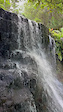
trail: Silver Falls
0:13 |
21 |
Jan 25, 2023
trail: Pipeline Track
0:12 |
159 |
Jan 25, 2023
trail: Pipeline Track
0:11 |
81 |
Jan 25, 2023
trail: Loam Line
0:00 |
110 |
Jul 25, 2022
Current Trail Warnings
| status | trail | date | condition | user | info |
|---|---|---|---|---|---|
| Oompa loompa | Jun 18, 2026 @ 1:26pm (Australia/Hobart) 1 day | Ideal | gkalis | Tree down blocking track |
Recent Trail Reports
Activity Feed
| username | action | type | title | date |
|---|---|---|---|---|
| gkalis | add | report | activity #97238361 | Jun 18, 2026 @ 1:47am 1 day |
| Sekt | update | trail | activity #97160605 | Jun 16, 2026 @ 8:49pm 2 days |
| maloneyrick | add | video | activity #97025276 | Jun 14, 2026 @ 11:37pm Jun 14, 2026 |
| maloneyrick | add | video | activity #97025145 and 1 more | Jun 14, 2026 @ 11:31pm Jun 14, 2026 |
| maloneyrick | add | video | activity #97024496 and 3 more | Jun 14, 2026 @ 11:06pm Jun 14, 2026 |
Recent Comments
| username | type | title | comment | date |
|---|---|---|---|---|
| trail | Very fun, not too long, easy to do laps of.... | Jun 6, 2026 @ 12:32am Jun 6, 2026 | ||
| trail | Since the re-vamp it’s been running real nice | Jun 6, 2026 @ 12:28am Jun 6, 2026 | ||
| trail | Track has been greatly improved with recent... | May 30, 2026 @ 9:51pm May 30, 2026 | ||
| trail | Look forward to riding it | May 23, 2026 @ 4:44am May 23, 2026 | ||
| trail | I | May 15, 2026 @ 8:39pm May 15, 2026 |
Local Badges
-

Completionist0 awarded -
Completionist0 awarded -
Completionist0 awarded -
Completionist0 awarded -
Completionist0 awarded -
Completionist0 awarded
Bike & Skill Parks
| name | type | city | rating |
|---|---|---|---|
| Meadowbank MTB | bike park | Hobart | |
| Geilston Bay Jump Track | skill park | Hobart | |
| Waterworks Pump Track | skill park | Hobart | |
| Lauderdale BMX Track | skill park | Hobart |
Local Trail Supporters
![City of Hobart]()
- Hobart City Council
Activity Type Stats
| activitytype | trails | distance | descent | descent distance | total vertical | rating | global rank | state rank | photos | reports | routes | ridelogs |
|---|---|---|---|---|---|---|---|---|---|---|---|---|
| Mountain Bike | 593 | 407 miles | 93,576 ft | 202 miles | 3,717 ft | #54 | #6 | 834 | 4,331 | 40 | 108,625 | |
| E-Bike | 602 | 426 miles | 100,659 ft | 214 miles | 4,127 ft | #50 | #27 | 4 | 4,021 | 15 | 10,024 | |
| Gravel Bike | 1 | #44 | #74 | 28 | 17 | 2 | 301 | |||||
| Horse | 18 | 34 miles | 4,213 ft | 15 miles | 1,650 ft | #214 | #19 | 3 | 436 | 2 | ||
| Hike | 540 | 430 miles | 91,509 ft | 193 miles | 4,505 ft | #80 | #8 | 27 | 4,058 | 1 | 5,375 | |
| Trail Running | 538 | 428 miles | 91,319 ft | 192 miles | 4,505 ft | #91 | #10 | 4,055 | 7 | 12,103 | ||
| Dirtbike/Moto | 5 | 24 miles | 1,946 ft | 11 miles | 1,542 ft | #197 | #7 | 436 | 13 | |||
| Observed Trials | 1 | 2 | 12 | |||||||||
| ATV/ORV/OHV | 6 | 37 miles | 2,349 ft | 18 miles | 1,542 ft | #99 | #8 | 3 | 436 | 4 |
Frequently Asked Questions About Hobart
▼
What are the best places to ride in Hobart?
Hobart has 21 areas to explore for mountain biking. The top rated areas are:
▼
What are the highest rated mountain biking trails in Hobart?
The highest rated mountain biking trails in Hobart are:
- North-South Track (4.6/5)
- Flow Monster (4.4/5)
- XC Loop Lower (4.4/5)
- Drops (4.4/5)
- Simmons Hill Descent (4.4/5)
▼
What is the best time of the year to ride in Hobart?
Based on ride log data, the most popular months to ride in Hobart are:
- February (746 activities)
- October (698 activities)
- July (694 activities)
▼
Where can I park to ride in Hobart?
There are 27 parking locations listed in Hobart. The most popular parking spots are: View all parking and trailhead locations on the map to plan your visit.
Activities
Trails
Points of Interest
- Loddon River East Bank Camping
- Yellow Toolbox Tent Platform Camping
- Mount Connection Summit
- Cathedral Rock Summit
- Mount Montagu Summit
- Devils Throne Summit
- Tom Thumb Summit
- Mill Creek Campsite Camping
- Fortescue Bay Campground Camping
- High Tensile - Fence Jump TTF
- Frenchmans Cap (1,336 m)
- kunanyi / Mount Wellington (1,262 m)
- Philps Peak (1,261 m)
- By SchrodingersGat
 MRTG & contributors
 - Admins: Sekt, SchrodingersGat, Sekt
- #9725 - 67,311 views
- hobart activity log | embed map of Hobart mountain bike trails | hobart mountain biking points of interest
Downloading of trail gps tracks in kml & gpx formats is enabled for Hobart.
You must login to download files.