close
-
Layers w
- Weather Layers
- Pro
- Pro
- Pro
- Pro
- Pro
- Pro
- More Layers
- Pro
- Pro
- Pro
- Pro
-
Upgrade to

3D
Trail Conditions
- Unknown
- Snow Groomed
- Snow Packed
- Snow Covered
- Snow Cover Partial
- Freeze/thaw Cycle
- Icy
- Prevalent Mud
- Wet
- Variable
- Ideal
- Dry
- Very Dry
Trail Flow (Ridden Direction)
Trailforks scans users ridelogs to determine the most popular direction each trail is ridden. A good flowing trail network will have most trails flowing in a single direction according to their intension.
The colour categories are based on what percentage of riders are riding a trail in its intended direction.
The colour categories are based on what percentage of riders are riding a trail in its intended direction.
- > 96%
- > 90%
- > 80%
- > 70%
- > 50%
- < 50%
- bi-directional trail
- no data
Trail Last Ridden
Trailforks scans ridelogs to determine the last time a trail was ridden.
- < 2 days
- < 1 week
- < 2 weeks
- < 1 month
- < 6 months
- > 6 months
Trail Ridden Direction
The intended direction a trail should be ridden.
- Downhill Only
- Downhill Primary
- Both Directions
- Uphill Primary
- Uphill Only
- One Direction
Contribute Details
Colors indicate trail is missing specified detail.
- Description
- Photos
- Description & Photos
- Videos
Trail Popularity ?
Trailforks scans ridelogs to determine which trails are ridden the most in the last 9 months.
Trails are compared with nearby trails in the same city region with a possible 25 colour shades.
Think of this as a heatmap, more rides = more kinetic energy = warmer colors.
- most popular
- popular
- less popular
- not popular
ATV/ORV/OHV Filter
Max Vehicle Width
inches
US Cell Coverage
Legend

Radar Time
Activity Recordings
Trailforks uses anonymized public activity data.
?
Activity Recordings
Trailforks uses anonymized public activity data.
?
Personal Heatmap
▶
Activity Types
all
/
none
▶
Options
2
Date range
month
–
Winter Trails
Warning
A routing network for winter maps does not exist. Selecting trails using the winter trails layer has been disabled.
Missing Trails
Most Popular
Least Popular
Trails are colored based on popularity. The more popular a trail is, the more red. Less popular trails trend towards green.
Jump Magnitude Heatmap
Heatmap of where riders jump on trails. Zoom in to see individual jumps, click circles to view jump details.
BC Backroad Status
![map legend]()
Service Road Atlas is a free to use, community-driven service for viewing and creating reports on the numerous back-country service roads around B.C. and Alberta.

Slope Aspect
Direction the slope faces
Trails Deemphasized
Trails are shown in grey.
Only show trails with no bike usage.
Suggested Layers
Based on selected activity type
Save the current map location and zoom level as your default home location whenever this page is loaded.
Save
No description for Holly has been added yet!
Login or register to submit one.
Activities Click to view
- Mountain Bike
51 trails
- Gravel Bike
5 trails
- Adaptive Bike
0 trails
- Winter Fat Bike
0 trails
- Hike
58 trails
- Trail Running
58 trails
- Snowshoe
21 trails
- Downhill Ski
20 trails
- Backcountry Ski
21 trails
- Nordic Ski
0 trails
Region Details
- 7
- 26
- 17
- 1
Region Status
Open as of Jan 16, 2026Stats
- Avg Trail Rating
- Trails (view details)
- 75
- Trails Mountain Bike
- 51
- Trails Gravel Bike
- 5
- Trails Hike
- 58
- Trails Trail Running
- 58
- Trails Snowshoe
- 21
- Trails Downhill Ski
- 20
- Trails Backcountry Ski
- 21
- Total Distance
- 41 miles
- Total Descent
- 3,896 ft
- Total Vertical
- 280 ft
- Highest Trailhead
- 1,201 ft
- Reports
- 333
- Photos
- 51
- Ridden Counter
- 3,649
Sub Regions
-
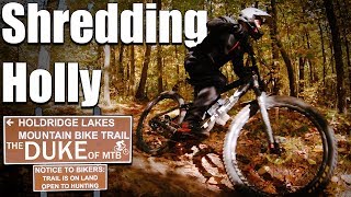
Holly Recreation Area
-
Holly-Holdridge Mountain Bike Trail
- 8
- 17
- 1
-
The Foundation Trail at Holly High School
- 4
Popular Holly Mountain Biking Trails
• 100 ★ 4.4 • 4 miles • 287 ft • 400 •
Part of the Holly Recreation Area, the trail system consists of three main loops, North, West, and East. The Holdridge Trail system's flagship feature is the east loop, a 15.5 mile advanced trail, Gruber's Grinder. It is very technical,...
• 80 ★ 4.0 • 823 ft • 9 ft • 358 •
Popular blue difficulty singletrack. This multi-use trail can be used both directions. On average it takes 3 minutes to complete this trail.
• 80 ★ 4.0 • 3,698 ft • 47 ft • 333 •
Highly rated popular black diamond difficulty singletrack. This mountain bike primary trail can be used uphill primary. On average it takes 5 minutes to complete this trail.
• 70 ★ 4.4 • 1 mile • 123 ft • 299 •
Popular blue difficulty singletrack. This mountain bike primary trail can be used uphill primary. On average it takes 9 minutes to complete this trail.
• 100 ★ 4.5 • 1 mile • 45 ft • 286 •
Part of the Holly Recreation Area, the trail system consists of three main loops, North, West, and East. The Holdridge Trail system's flagship feature is the east loop, a 15.5 mile advanced trail, Gruber's Grinder. It is very technical,...
• 60 ★ 4.5 • 4,285 ft • 82 ft • 284 •
Moderately popular blue difficulty singletrack. This mountain bike primary trail can be used uphill primary. On average it takes 5 minutes to complete this trail.
• 60 ★ 5.0 • 4,350 ft • 65 ft • 281 •
Moderately popular blue difficulty singletrack. This mountain bike primary trail can be used uphill primary. On average it takes 7 minutes to complete this trail.
• 55 ★ 5.0 • 1 mile • 82 ft • 280 •
Moderately popular blue difficulty singletrack. This mountain bike primary trail can be used uphill primary. On average it takes 9 minutes to complete this trail.
Holly Mountain Bike Routes
19 miles • 1,234 ft • 21 • Loop •
Combines all loops of holly into one combined ride. Starting easy, then , then advanced big loop.
Videos of Holly Mountain Bike
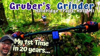
9:01 |
416 |
Sep 19, 2022

trail: West loop
15:33 |
395 |
May 4, 2022 , Holly
trail: Parking Lot
0:19 |
184 |
Apr 7, 2009

trail: West loop
14:05 |
583 |
Jul 29, 2019 , Holly
youtuber
![Is That a Skinny or Just a Random Log? •...]()

14:05 |
361 |
Jul 29, 2019

trail: West loop
2:14 |
380 |
Oct 23, 2018 , Holly

trail: Tech Loop
3:50 |
600 |
Oct 15, 2018 , Holly
Recent Trail Reports
| status | trail | date | condition | info | user |
|---|---|---|---|---|---|
| Holly Wilderness Trail #1-#2 | Jan 16, 2026 @ 4:38pm (America/Detroit) Jan 16, 2026 | Snow Packed | alexQlvIGU | ||
| Holly Wilderness Trail #15-#1 | Jan 16, 2026 @ 4:38pm (America/Detroit) Jan 16, 2026 | Snow Packed | alexQlvIGU | ||
| Holly Wilderness Trail #14-#15 | Jan 16, 2026 @ 4:38pm (America/Detroit) Jan 16, 2026 | Snow Packed | alexQlvIGU | ||
| Holly Wilderness Trail #12-#13 | Jan 16, 2026 @ 4:38pm (America/Detroit) Jan 16, 2026 | Snow Packed | alexQlvIGU | ||
| Holly Wilderness Trail #9-#10 | Jan 16, 2026 @ 4:38pm (America/Detroit) Jan 16, 2026 | Snow Packed | alexQlvIGU | ||
| Holly Wilderness Trail #8-#9 | Jan 16, 2026 @ 4:38pm (America/Detroit) Jan 16, 2026 | Snow Packed | alexQlvIGU | ||
| Holly Wilderness Trail #7-#8 | Jan 16, 2026 @ 4:38pm (America/Detroit) Jan 16, 2026 | Snow Packed | alexQlvIGU | ||
| West loop | Nov 5, 2025 @ 2:27pm (America/Detroit) Nov 5, 2025 | Variable | jer091 CRAMBA | ||
| North Loop | Nov 5, 2025 @ 2:27pm (America/Detroit) Nov 5, 2025 | Variable | jer091 CRAMBA | ||
| Access Rd 2 | Nov 5, 2025 @ 2:27pm (America/Detroit) Nov 5, 2025 | Ideal | jer091 CRAMBA |
Activity Feed
| username | action | type | title | date |
|---|---|---|---|---|
| alexmillhisler | wishlist | region | activity #96689532 | Jun 10, 2026 @ 12:21pm Jun 10, 2026 |
| VFL0311 | vote | trail | activity #96030005 | Jun 1, 2026 @ 11:16am Jun 1, 2026 |
| DoSaU | wishlist | route | activity #95764142 | May 29, 2026 @ 3:05am May 29, 2026 |
| VFL0311 | wishlist | route | activity #95752656 | May 28, 2026 @ 7:48pm May 28, 2026 |
| H9Jl09 | wishlist | region | activity #93741965 | Apr 30, 2026 @ 4:31pm Apr 30, 2026 |
Recent Comments
| username | type | title | comment | date |
|---|---|---|---|---|
| trail | Mostly a green level trail. You can only... | May 17, 2025 @ 1:16pm May 17, 2025 | ||
| trail | Should be rated green. Loads of green alfae... | Sep 10, 2023 @ 9:25am Sep 10, 2023 | ||
| trail | Should be rated Blue. The tree rides are all... | Sep 10, 2023 @ 9:23am Sep 10, 2023 | ||
| trail | Trail is in excellent condition | Jan 24, 2021 @ 10:49pm Jan 24, 2021 | ||
| trail | This trail is pretty easy for kids and... | Aug 26, 2020 @ 8:46pm Aug 26, 2020 |
Local Badges
-

10 Blue Trails77 awarded -

Epic Mountain Bike Climb 2k0 awarded -

Climbing 10k Badge6 awarded -

Mountain Biking 100k Badge0 awarded -

Epic Ride Descent 2k0 awarded -

Descent 10k Badge6 awarded
Activity Type Stats
| activitytype | trails | distance | descent | descent distance | total vertical | rating | global rank | state rank | photos | reports | routes | ridelogs |
|---|---|---|---|---|---|---|---|---|---|---|---|---|
| Mountain Bike | 51 | 34 miles | 2,516 ft | 11 miles | 174 ft | #2,458 | #876 | 50 | 333 | 3 | 5,885 | |
| Gravel Bike | 5 | 4 miles | 223 ft | 1 mile | 79 ft | #636 | #1,178 | 23 | 179 | |||
| Hike | 58 | 38 miles | 2,690 ft | 12 miles | 174 ft | #5,648 | #1,988 | 333 | 162 | |||
| Trail Running | 58 | 38 miles | 2,690 ft | 12 miles | 174 ft | #5,158 | #1,618 | 333 | 11 | |||
| Snowshoe | 21 | 9 miles | 623 ft | 3 miles | 121 ft | #1,275 | #689 | 2 | 7 | |||
| Downhill Ski | 20 | 3 miles | 1,204 ft | 2 miles | 217 ft | #484 | #199 | 92 | ||||
| Backcountry Ski | 21 | 9 miles | 623 ft | 3 miles | 121 ft | #628 | #217 | 2 |
Frequently Asked Questions About Holly
▼
What are the best places to ride in Holly?
Holly has 4 areas to explore for mountain biking. The top rated areas are:
▼
What are the highest rated mountain biking trails in Holly?
The highest rated mountain biking trails in Holly are:
- East loop #2 - #3 (4.2/5)
- North Loop (4.2/5)
- East loop #1 - #2 (4.2/5)
- West loop (4.2/5)
- East loop #6 - #7 (4.1/5)
▼
What is the best time of the year to ride in Holly?
Based on ride log data, the most popular months to ride in Holly are:
- June (59 activities)
- August (55 activities)
- May (51 activities)
▼
Where can I park to ride in Holly?
Activities
- By markholloway
 Trailforks Map Team & contributors
 - Admins: MCMBA
- #11538 - 2,280 views
- holly activity log | embed map of Holly mountain bike trails | holly mountain biking points of interest
Downloading of trail gps tracks in kml & gpx formats is enabled for Holly.
You must login to download files.