close
-
Layers w
- Weather Layers
- Pro
- Pro
- Pro
- Pro
- Pro
- Pro
- More Layers
- Pro
- Pro
- Pro
- Pro
-
Upgrade to

3D
Trail Conditions
- Unknown
- Snow Groomed
- Snow Packed
- Snow Covered
- Snow Cover Partial
- Freeze/thaw Cycle
- Icy
- Prevalent Mud
- Wet
- Variable
- Ideal
- Dry
- Very Dry
Trail Flow (Ridden Direction)
Trailforks scans users ridelogs to determine the most popular direction each trail is ridden. A good flowing trail network will have most trails flowing in a single direction according to their intension.
The colour categories are based on what percentage of riders are riding a trail in its intended direction.
The colour categories are based on what percentage of riders are riding a trail in its intended direction.
- > 96%
- > 90%
- > 80%
- > 70%
- > 50%
- < 50%
- bi-directional trail
- no data
Trail Last Ridden
Trailforks scans ridelogs to determine the last time a trail was ridden.
- < 2 days
- < 1 week
- < 2 weeks
- < 1 month
- < 6 months
- > 6 months
Trail Ridden Direction
The intended direction a trail should be ridden.
- Downhill Only
- Downhill Primary
- Both Directions
- Uphill Primary
- Uphill Only
- One Direction
Contribute Details
Colors indicate trail is missing specified detail.
- Description
- Photos
- Description & Photos
- Videos
Trail Popularity ?
Trailforks scans ridelogs to determine which trails are ridden the most in the last 9 months.
Trails are compared with nearby trails in the same city region with a possible 25 colour shades.
Think of this as a heatmap, more rides = more kinetic energy = warmer colors.
- most popular
- popular
- less popular
- not popular
ATV/ORV/OHV Filter
Max Vehicle Width
inches
US Cell Coverage
Legend

Radar Time
Activity Recordings
Trailforks uses anonymized public activity data.
?
Activity Recordings
Trailforks uses anonymized public activity data.
?
Personal Heatmap
▶
Activity Types
all
/
none
▶
Options
2
Date range
month
–
Winter Trails
Warning
A routing network for winter maps does not exist. Selecting trails using the winter trails layer has been disabled.
Missing Trails
Most Popular
Least Popular
Trails are colored based on popularity. The more popular a trail is, the more red. Less popular trails trend towards green.
Jump Magnitude Heatmap
Heatmap of where riders jump on trails. Zoom in to see individual jumps, click circles to view jump details.
BC Backroad Status
![map legend]()
Service Road Atlas is a free to use, community-driven service for viewing and creating reports on the numerous back-country service roads around B.C. and Alberta.

Slope Aspect
Direction the slope faces
Trails Deemphasized
Trails are shown in grey.
Only show trails with no bike usage.
Suggested Layers
Based on selected activity type
Save the current map location and zoom level as your default home location whenever this page is loaded.
Save
No description for Hoogerheide has been added yet!
Login or register to submit one.
Activities Click to view
- Mountain Bike
8 trails
- E-Bike
5 trails
- Adaptive Bike
0 trails
- Hike
2 trails
- Trail Running
2 trails
Region Details
- 2
- 1
- 1
Region Status
Caution as of May 30, 2026Stats
- Avg Trail Rating
- Trails (view details)
- 4
- Trails Mountain Bike
- 8
- Trails E-Bike
- 5
- Trails Hike
- 2
- Trails Trail Running
- 2
- Total Distance
- 12 miles
- Total Descent Distance
- 3 miles
- Total Descent
- 453 ft
- Total Vertical
- 81 ft
- Highest Trailhead
- 105 ft
- Reports
- 40
- Ridden Counter
- 767
Popular Hoogerheide Mountain Biking Trails
• 50 ★ 4.4 • 4 miles • 173 ft • 207 •
Moderately popular green difficulty singletrack. This mountain bike primary trail can be used one direction. On average it takes 21 minutes to complete this trail.
• 25 ★ 4.0 • 4 miles • 111 ft • 206 •
Less popular blue difficulty singletrack. This mountain bike primary trail can be used one direction and has a moderate overall physical rating with a 111 ft green climb. Trail visibility is always easy to follow. On average it takes 15 minutes to complete this trail.
• 75 ★ 4.0 • 4 miles • 178 ft • 188 •
https://grensparkkalmthoutseheide.com/en/mountainbike/
• 100 ★ 0.0 • 6 miles • 264 ft • 116 •
Popular green difficulty singletrack. This mountain bike primary trail.
Hoogerheide Mountain Bike Routes
4 miles • 113 ft • 0 •
Part of the grenspark route which are 4 loops with a connecting track
4 miles • 178 ft • 0 •
Part of the grenspark route which are 4 loops connected by a large loop
4 miles • 119 ft • 0 •
Part of the grenspark route which are 4 loops connected by a large loop
6 miles • 248 ft • 0 •
Part of the grenspark route which are 4 loops connected by a large loop
5 miles • 203 ft • 0 • Loop •
Nice single track. Short but intensive.
Videos of Hoogerheide Mountain Bike
youtuber
![MTB Challenge // Ossendrecht Stoppelbergen]()

trail: Stoppelbergen Tegenwijzerzin
6:00 |
165 |
Jan 2, 2024 , Hoogerheide
youtuber
![MTB Challenge // Huijbergen]()

5:05 |
174 |
Jan 2, 2024 , Hoogerheide
youtuber
![MTB Challenge // Ossendrecht volksabdij]()
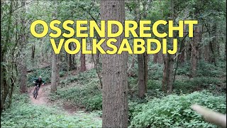
trail: Volksabdij Tegenwijzerzin
7:42 |
148 |
Jan 2, 2024 , Hoogerheide
Recent Trail Reports
| status | trail | date | condition | info | user |
|---|---|---|---|---|---|
| Stoppelbergen Tegenwijzerzin | May 31, 2026 @ 8:51am (Europe/Brussels) May 30, 2026 | Dry | jens212 | ||
| Volksabdij Tegenwijzerzin | Aug 10, 2025 @ 2:57pm Aug 10, 2025 | Dry | michel0118 | ||
| Wildernissen wijzerzin | Nov 24, 2024 @ 12:39pm Nov 24, 2024 | Variable | MultiVAC86 | ||
| Staartse Heide Tegenwijzerzin | Aug 17, 2024 @ 11:52am Aug 17, 2024 | Wet | Vermast |
Activity Feed
| username | action | type | title | date |
|---|---|---|---|---|
| jens212 | add | report | activity #95939328 | May 31, 2026 @ 7:46am May 31, 2026 |
| Wesley1988 | ridden | trail | activity #87795296 | Jan 25, 2026 @ 8:35am Jan 25, 2026 |
| KarinqsA9Fw | ridden | trail | activity #79774849 | Sep 6, 2025 @ 11:44am Sep 6, 2025 |
| michel0118 | add | report | activity #77892503 | Aug 11, 2025 @ 3:33am Aug 11, 2025 |
| PatjeVerhoeven | wishlist | trail | activity #73325739 | Jun 8, 2025 @ 2:45am Jun 8, 2025 |
Recent Comments
| username | type | title | comment | date |
|---|---|---|---|---|
| trail | Welke features kun je hier vinden ? | Jun 24, 2022 @ 10:14am Jun 24, 2022 |
Bike & Skill Parks
| name | type | city | rating |
|---|---|---|---|
| Rilland MX | skill park | Hoogerheide |
Activity Type Stats
| activitytype | trails | distance | descent | descent distance | total vertical | rating | global rank | state rank | photos | reports | routes | ridelogs |
|---|---|---|---|---|---|---|---|---|---|---|---|---|
| Mountain Bike | 8 | 12 miles | 453 ft | 3 miles | 82 ft | #6,149 | #46 | 40 | 5 | 9,348 | ||
| E-Bike | 5 | 4 miles | 115 ft | 5,279 ft | 39 ft | #1,837 | #16 | 37 | 1 | 446 | ||
| Hike | 2 | 4 miles | 177 ft | 5,128 ft | 33 ft | #5,012 | #58 | 39 | 149 | |||
| Trail Running | 2 | 4 miles | 177 ft | 5,128 ft | 33 ft | #4,444 | #59 | 39 | 18 |
- By Mth005 & contributors
- Admins: apply
- #22901 - 1,579 views
- hoogerheide activity log | embed map of Hoogerheide mountain bike trails |
Downloading of trail gps tracks in kml & gpx formats is enabled for Hoogerheide.
You must login to download files.