close
-
Layers w
- Weather Layers
- Pro
- Pro
- Pro
- Pro
- Pro
- Pro
- More Layers
- Pro
- Pro
- Pro
- Pro
-
Upgrade to

3D
Trail Conditions
- Unknown
- Snow Groomed
- Snow Packed
- Snow Covered
- Snow Cover Partial
- Freeze/thaw Cycle
- Icy
- Prevalent Mud
- Wet
- Variable
- Ideal
- Dry
- Very Dry
Trail Flow (Ridden Direction)
Trailforks scans users ridelogs to determine the most popular direction each trail is ridden. A good flowing trail network will have most trails flowing in a single direction according to their intension.
The colour categories are based on what percentage of riders are riding a trail in its intended direction.
The colour categories are based on what percentage of riders are riding a trail in its intended direction.
- > 96%
- > 90%
- > 80%
- > 70%
- > 50%
- < 50%
- bi-directional trail
- no data
Trail Last Ridden
Trailforks scans ridelogs to determine the last time a trail was ridden.
- < 2 days
- < 1 week
- < 2 weeks
- < 1 month
- < 6 months
- > 6 months
Trail Ridden Direction
The intended direction a trail should be ridden.
- Downhill Only
- Downhill Primary
- Both Directions
- Uphill Primary
- Uphill Only
- One Direction
Contribute Details
Colors indicate trail is missing specified detail.
- Description
- Photos
- Description & Photos
- Videos
Trail Popularity ?
Trailforks scans ridelogs to determine which trails are ridden the most in the last 9 months.
Trails are compared with nearby trails in the same city region with a possible 25 colour shades.
Think of this as a heatmap, more rides = more kinetic energy = warmer colors.
- most popular
- popular
- less popular
- not popular
ATV/ORV/OHV Filter
Max Vehicle Width
inches
US Cell Coverage
Legend

Radar Time
Activity Recordings
Trailforks uses anonymized public activity data.
?
Activity Recordings
Trailforks uses anonymized public activity data.
?
Personal Heatmap
▶
Activity Types
all
/
none
▶
Options
2
Date range
month
–
Winter Trails
Warning
A routing network for winter maps does not exist. Selecting trails using the winter trails layer has been disabled.
Missing Trails
Most Popular
Least Popular
Trails are colored based on popularity. The more popular a trail is, the more red. Less popular trails trend towards green.
Jump Magnitude Heatmap
Heatmap of where riders jump on trails. Zoom in to see individual jumps, click circles to view jump details.
BC Backroad Status
![map legend]()
Service Road Atlas is a free to use, community-driven service for viewing and creating reports on the numerous back-country service roads around B.C. and Alberta.

Slope Aspect
Direction the slope faces
Trails Deemphasized
Trails are shown in grey.
Only show trails with no bike usage.
Suggested Layers
Based on selected activity type
Save the current map location and zoom level as your default home location whenever this page is loaded.
Save
No description for Hope has been added yet!
Login or register to submit one.
Activities Click to view
- Mountain Bike
66 trails
- E-Bike
36 trails
- Gravel Bike
0 trails
- Adaptive Bike
0 trails
- Winter Fat Bike
0 trails
- Hike
118 trails
- Trail Running
114 trails
- Dirtbike/Moto
226 trails
- ATV/ORV/OHV
25 trails
- Snowmobile
28 trails
- Snowshoe
51 trails
- Backcountry Ski
40 trails
- Nordic Ski
18 trails
Region Details
- 21
- 3
- 13
- 19
- 9
Region Status
Caution as of Jun 20, 2026Local Trail Association
Stats
- Avg Trail Rating
- Trails (view details)
- 308
- Trails Mountain Bike
- 68
- Trails E-Bike
- 36
- Trails Horse
- 3
- Trails Hike
- 118
- Trails Trail Running
- 114
- Trails Dirtbike/Moto
- 241
- Trails Observed Trials
- 1
- Trails ATV/ORV/OHV
- 25
- Trails Snowmobile
- 28
- Trails Snowshoe
- 51
- Trails Backcountry Ski
- 40
- Trails Nordic Ski
- 18
- Total Distance
- 741 miles
- Total Descent
- 76,781 ft
- Total Vertical
- 7,917 ft
- Highest Trailhead
- 8,020 ft
- Reports
- 344
- Photos
- 482
- Ridden Counter
- 9,145
Articles
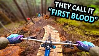
Video: Remy Metailler & Dean Tennant Ride the new First Blood Trail in Hope, BC
Jul 3, 2025 from pinkbike.com
The First Blood Trail, named after the first Rambo movie, has been in the works for a while and has just opened. It looks so good.
Sub Regions
-
Coquihalla Summit Recreation Area
- 2
-
Hope Community Forest
- 1
- 4
-
Hope Mountain
- 1
- 6
-
Skagit Valley Provincial Park
- 2
-
Skawahlook Adventure Park
- 6
- 1
-
Sunshine Valley
- 2
- 3
- 4
-
Thatcher Regional Park
- 2
-
The Core
Popular Hope Mountain Biking Trails
• 100 ★ 4.4 • 3 miles • 133 ft • 124 •
Hope's newest downhill shuttle trail. The trail-rating could easily jump up to Double-Black in wet conditions. This is a wilderness trail that requires skills and endurance. Be prepared for minimal cell-service reception. The trails...
• 95 ★ 5.0 • 3,629 ft • 3 ft • 58 •
Comes off of and starts a new section that was built by the locals. is a bit of a little peddle to start and then it opens up into fun downhill part that lands you back on the double track to connect onto the lower half of the older...
• 75 ★ 0.0 • 4,967 ft • 18 ft • 34 •
Popular blue difficulty singletrack. This multi-use trail can be used both directions. On average it takes 11 minutes to complete this trail.
• 5 ★ 4.7 • 1 mile • 76 ft • 32 •
Hike to the top using the climbing trail. Then rip down the mountain all the way to Kawkwa Lake. Trail is fairly new with jump and drops and some steep and technical areas. At a point branch off and try and newly added . Two different...
• 70 ★ 0.0 • 4,058 ft • 461 ft • 27 •
Loop that takes you to Othello Decent trail. Then from there you can go to Kettle Valley Road or back to the Othello tunnels parking lot.
• 80 ★ 5.0 • 2,822 ft • 15 ft • 27 •
Longer hikin/biking loop starting at the playground and ending at the Salmon Bridge
• 75 ★ 5.0 • 1,230 ft • 3 ft • 26 •
North East hiking/biking loop trail in the adventure park.
Hope Mountain Bike Routes
★ 5.0 • 8 miles • 1,220 ft • 0 •
Start at the end of the Kettle Valley Road. Yellow Gate. Note tunnels must be open for full loop to be in...
7 miles • 1,635 ft • 4 •
Sunshine Valley to former Silvertip ski hill. Please respect speed limits in residential areas.
★ 4.0 • 47 miles • 5,040 ft • 0 • Point to Point •
1010300 1of12 InteriorBC - 03 Hope, BC to Manning Park, BC (Mule Deer Campground) 75km
Photos of Hope Mountain Bike
Videos of Hope Mountain Bike
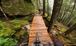
trail: Macho Mango
0:07 |
|
Jun 4, 2019
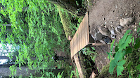
trail: Macho Mango
0:15 |
|
Jun 4, 2019
6:49 |
16 |
May 14, 2016
5:25 |
14785 |
Nov 25, 2015
0:55 |
2514 |
Jun 22, 2015
youtuber
![The Rambo trail: brutally honest review of...]()

trail: First Blood
20:27 |
384 |
Aug 21, 2025 , Hope
trail: Gorilla
7:12 |
176 |
Jul 21, 2025 , Hope
youtuber
![EPIC 1000m Descent! - This Brand New MTB Trail...]()
trail: First Blood
23:46 |
227 |
Jul 18, 2025 , Hope
Current Trail Warnings
| status | trail | date | condition | user | info |
|---|---|---|---|---|---|
| Hope to Tunnels | Jun 17, 2026 @ 9:04pm (America/Vancouver) Jun 17, 2026 | Dry | frazzle | Trail is closed after tunnel 5 from the... |
Recent Trail Reports
| status | trail | date | condition | info | user |
|---|---|---|---|---|---|
| Macho Mango | Jun 20, 2026 @ 3:49pm (America/Vancouver) Jun 20, 2026 | Ideal | Gaabaashaa | ||
| Gorilla Uphill Hike to DH | Jun 20, 2026 @ 3:49pm (America/Vancouver) Jun 20, 2026 | Ideal | Gaabaashaa | ||
| First Blood | Jun 11, 2026 @ 8:39am (America/Vancouver) Jun 11, 2026 | Unknown | reirameso | ||
| Flood Falls Loop | May 24, 2026 @ 12:49pm (America/Vancouver) May 24, 2026 | Unknown | gerrycreighton WMBC staff | ||
| Jones Lake Forest Service Road | Apr 12, 2026 @ 1:39pm (America/Vancouver) Apr 12, 2026 | Dry | peyterek | ||
| Columbia | Mar 21, 2026 @ 7:50am (America/Vancouver) Mar 21, 2026 | Unknown | sheriffteasel FVMBA - Hope | ||
| FSR Access Road | Mar 15, 2026 @ 9:44am (America/Vancouver) Mar 15, 2026 | Unknown | sheriffteasel FVMBA - Hope | ||
| Skills Trail | Oct 3, 2025 @ 8:33pm (America/Vancouver) Oct 3, 2025 | Wet | colbyRE5Q2f | ||
| Access Trail | Sep 14, 2025 @ 10:14pm (America/Vancouver) Sep 14, 2025 | Variable | hdobson188 EMBA-EC | ||
| Lion King | Aug 18, 2025 @ 4:39pm Aug 18, 2025 | Dry | aarondodd SVATVC |
Activity Feed
| username | action | type | title | date |
|---|---|---|---|---|
| Melristo | ridden | trail | activity #98031719 | Jun 28, 2026 @ 4:07pm 8 hours |
| Canadmos | add | trail | activity #97707218 | Jun 24, 2026 @ 10:18am Jun 24, 2026 |
| Davidssvo | wishlist | trail | activity #97672864 | Jun 23, 2026 @ 8:41pm Jun 23, 2026 |
| masonguy | difficultyvote | trail | activity #97541657 | Jun 21, 2026 @ 9:12pm Jun 21, 2026 |
| masonguy | vote | trail | activity #97541654 | Jun 21, 2026 @ 9:12pm Jun 21, 2026 |
Recent Comments
| username | type | title | comment | date |
|---|---|---|---|---|
| trail | Drove out from Washington to ride this solo on... | Jun 19, 2026 @ 11:07pm Jun 19, 2026 | ||
| report | Trail needs some serious maintenance. Do not... | May 7, 2026 @ 12:03am May 7, 2026 | ||
| trail | She still alive? | Apr 14, 2026 @ 12:07pm Apr 14, 2026 | ||
| trail | It's much steeper than Pingu and Pangor. Those... | Apr 14, 2026 @ 11:50am Apr 14, 2026 | ||
| trail | I don't ride Whistler much. Any comparisons... | Apr 14, 2026 @ 10:29am Apr 14, 2026 |
Local Badges
-

Epic Ride Climb 2k47 awarded -

Climbing 10k Badge0 awarded -

Climbing 100k Badge0 awarded -

Epic Ride Descent 2k47 awarded -

Descent 10k Badge0 awarded -

Descent 100k Badge0 awarded
Bike & Skill Parks
| name | type | city | rating |
|---|---|---|---|
| Hope Bike Park | skill park | Hope | |
| Rocky Roller Park | skill park | Hope |
Activity Type Stats
| activitytype | trails | distance | descent | descent distance | total vertical | rating | global rank | state rank | photos | reports | routes | ridelogs |
|---|---|---|---|---|---|---|---|---|---|---|---|---|
| Mountain Bike | 66 | 84 miles | 12,247 ft | 25 miles | 4,528 ft | #2,329 | #74 | 369 | 295 | 3 | 1,560 | |
| E-Bike | 36 | 41 miles | 961 ft | 5 miles | 4,065 ft | #2,688 | #71 | 2 | 260 | 2 | 142 | |
| Horse | 3 | 6 miles | 476 ft | 1 mile | 1,562 ft | 9 | ||||||
| Hike | 118 | 150 miles | 24,859 ft | 43 miles | 6,713 ft | #767 | #48 | 61 | 284 | 2 | 1,779 | |
| Trail Running | 114 | 148 miles | 24,101 ft | 43 miles | 6,713 ft | #979 | #44 | 284 | 4 | 182 | ||
| Dirtbike/Moto | 226 | 587 miles | 36,306 ft | 55 miles | 4,715 ft | #10 | #5 | 15 | 220 | 1 | 560 | |
| Observed Trials | 1 | 6 | 1 | |||||||||
| ATV/ORV/OHV | 25 | 45 miles | 2,192 ft | 7 miles | 4,373 ft | #82 | #11 | 33 | 37 | 1 | 34 | |
| Snowmobile | 28 | 75 miles | 6,375 ft | 21 miles | 4,301 ft | #40 | #6 | 31 | 1 | 14 | ||
| Snowshoe | 51 | 60 miles | 6,572 ft | 13 miles | 5,394 ft | #291 | #27 | 38 | 1 | 58 | ||
| Backcountry Ski | 40 | 36 miles | 16,680 ft | 16 miles | 6,598 ft | #266 | #18 | 10 | 1,112 | |||
| Nordic Ski | 18 | 38 miles | 879 ft | 4 miles | 3,009 ft | #501 | #30 | 28 | 1 | 106 |
Frequently Asked Questions About Hope
▼
What are the best places to ride in Hope?
Hope has 11 areas to explore for mountain biking. The top rated areas are:
▼
What are the highest rated mountain biking trails in Hope?
The highest rated mountain biking trails in Hope are:
- Gorilla (4.3/5)
- Dog Mountain DH (4.3/5)
- First Blood (4.3/5)
- Macho Mango (4.2/5)
- Big Foot (4.1/5)
▼
What is the best time of the year to ride in Hope?
Based on ride log data, the most popular months to ride in Hope are:
- June (26 activities)
- July (19 activities)
- May (16 activities)
▼
Where can I park to ride in Hope?
There are 22 parking locations listed in Hope. The most popular parking spots are: View all parking and trailhead locations on the map to plan your visit.
Activities
Trails
Points of Interest
- Little Douglas Lake Campground Camping
- Cheif Pahallak Viewpoint
- A.C. Anderson Viewpoint
- Spirit Caves Sight
- Ottomite Mountain Summit
- Nak Peak Summit
- Thar Peak Summit
- Zupjok Peak Summit
- Zum Peak Campground Summit
- Vicuna Peak Summit
- Silvertip Mountain (2,582 m)
- Mount Rahm (2,579 m)
- Mount Rideout (2,411 m)
- By canadaka
 Trailforks & contributors
 - Admins: HOPE, caribooyj, FVMBA - ADMIN, lee5986, Hams, meghanjackson, Graham-Macaulay
- #974 - 22,218 views
- hope activity log | embed map of Hope mountain bike trails | hope mountain biking points of interest polygons
Downloading of trail gps tracks in kml & gpx formats is enabled for Hope.
You must login to download files.