close
-
Layers w
- Weather Layers
- Pro
- Pro
- Pro
- Pro
- Pro
- Pro
- More Layers
- Pro
- Pro
- Pro
- Pro
-
Upgrade to

3D
Trail Conditions
- Unknown
- Snow Groomed
- Snow Packed
- Snow Covered
- Snow Cover Partial
- Freeze/thaw Cycle
- Icy
- Prevalent Mud
- Wet
- Variable
- Ideal
- Dry
- Very Dry
Trail Flow (Ridden Direction)
Trailforks scans users ridelogs to determine the most popular direction each trail is ridden. A good flowing trail network will have most trails flowing in a single direction according to their intension.
The colour categories are based on what percentage of riders are riding a trail in its intended direction.
The colour categories are based on what percentage of riders are riding a trail in its intended direction.
- > 96%
- > 90%
- > 80%
- > 70%
- > 50%
- < 50%
- bi-directional trail
- no data
Trail Last Ridden
Trailforks scans ridelogs to determine the last time a trail was ridden.
- < 2 days
- < 1 week
- < 2 weeks
- < 1 month
- < 6 months
- > 6 months
Trail Ridden Direction
The intended direction a trail should be ridden.
- Downhill Only
- Downhill Primary
- Both Directions
- Uphill Primary
- Uphill Only
- One Direction
Contribute Details
Colors indicate trail is missing specified detail.
- Description
- Photos
- Description & Photos
- Videos
Trail Popularity ?
Trailforks scans ridelogs to determine which trails are ridden the most in the last 9 months.
Trails are compared with nearby trails in the same city region with a possible 25 colour shades.
Think of this as a heatmap, more rides = more kinetic energy = warmer colors.
- most popular
- popular
- less popular
- not popular
ATV/ORV/OHV Filter
Max Vehicle Width
inches
US Cell Coverage
Legend

Radar Time
Activity Recordings
Trailforks uses anonymized public activity data.
?
Activity Recordings
Trailforks uses anonymized public activity data.
?
Personal Heatmap
▶
Activity Types
all
/
none
▶
Options
2
Date range
month
–
Winter Trails
Warning
A routing network for winter maps does not exist. Selecting trails using the winter trails layer has been disabled.
Missing Trails
Most Popular
Least Popular
Trails are colored based on popularity. The more popular a trail is, the more red. Less popular trails trend towards green.
Jump Magnitude Heatmap
Heatmap of where riders jump on trails. Zoom in to see individual jumps, click circles to view jump details.
BC Backroad Status
![map legend]()
Service Road Atlas is a free to use, community-driven service for viewing and creating reports on the numerous back-country service roads around B.C. and Alberta.

Slope Aspect
Direction the slope faces
Trails Deemphasized
Trails are shown in grey.
Only show trails with no bike usage.
Suggested Layers
Based on selected activity type
Save the current map location and zoom level as your default home location whenever this page is loaded.
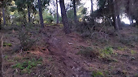
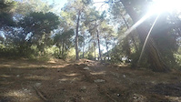
SaveExcellent trial center, easy access, fast and varied single tracks. The Northern part is steep and technical, the southern is milder - more like XC
Primary Trail Type: Cross-Country
AKA: הר חורשן
Land Status: Provincial Park
 google parking directions
 Access Info:
Bat shlomo
Amikam
Amikam
This region uses the Uk/Euro style trail grading system.
Activities Click to view
- Mountain Bike
80 trails
- E-Bike
80 trails
- Hike
71 trails
- Trail Running
73 trails
Region Details
- 17
- 22
- 20
- 19
- 2
Region Status
Open as of May 24, 2026Stats
- Avg Trail Rating
- Trails (view details)
- 80
- Trails Mountain Bike
- 80
- Trails E-Bike
- 80
- Trails Hike
- 71
- Trails Trail Running
- 73
- Total Distance
- 39 miles
- Total Descent
- 9,596 ft
- Total Vertical
- 461 ft
- Highest Trailhead
- 600 ft
- Reports
- 835
- Photos
- 13
- Ridden Counter
- 9,900
Popular Horeshan Mountain Biking Trails
• 95 ★ 4.0 • 1,624 ft • 15 ft • 246 •
Like many trails in Horeshan, this one is fast and with good flow. Also on the uphill it's not too demanding
• 100 ★ 3.0 • 1,003 ft • 17 ft • 242 •
Popular green difficulty singletrack. This mountain bike primary trail can be used both directions and has a easy overall physical rating with a 17 ft green climb. On average it takes 1 minutes to complete this trail.
• 100 ★ 4.4 • 5,195 ft • 20 ft • 226 •
Popular blue difficulty singletrack. This mountain bike primary trail can be used downhill primary and has a moderate overall physical rating with a 20 ft blue climb. On average it takes 8 minutes to complete this trail.
• 90 ★ 4.8 • 1,919 ft • 0 ft • 220 •
One of the more aggressive trails in the area, though it has no obstacles, but a sharp gradient, loose ground, curves and many bumps (thanks to the moto riders)
• 100 ★ 4.0 • 3,051 ft • 62 ft • 213 •
Popular green difficulty singletrack. This mountain bike primary trail can be used both directions. On average it takes 4 minutes to complete this trail.
• 90 ★ 4.0 • 3,455 ft • 2 ft • 205 •
A very smooth single track with almost a uniform gradient, that makes it the easiest choice for climbing after crossing (unlike choosing Behind The Fence, that start with a steep climb). Still it is a fast and refreshing easy decent for...
• 95 ★ 4.0 • 2,136 ft • 31 ft • 200 •
Popular green difficulty singletrack. This mountain bike primary trail can be used downhill primary and has a easy overall physical rating. On average it takes 3 minutes to complete this trail.
• 95 ★ 4.0 • 1,752 ft • 7 ft • 199 •
Popular blue difficulty singletrack. This mountain bike primary trail can be used downhill primary. On average it takes 2 minutes to complete this trail.
Photos of Horeshan Mountain Bike
Videos of Horeshan Mountain Bike

trail: Milwaukee
2:13 |
490 |
Oct 18, 2020

trail: Milwaukee
2:25 |
188 |
Sep 12, 2020
trail: The Liar
0:55 |
832 |
Feb 26, 2016
trail: The Liar
0:31 |
165 |
Jul 10, 2015

trail: The Peak
164 |
Mar 31, 2021 , Zihron Ya'akov

trail: Ehud 1
157 |
Mar 31, 2021 , Zihron Ya'akov

trail: New Zealand - The Jungle
0:51 |
258 |
Oct 30, 2020 , Zihron Ya'akov

trail: Cyprus
2:17 |
277 |
Oct 30, 2020 , Zihron Ya'akov
Recent Trail Reports
| status | trail | date | condition | info | user |
|---|---|---|---|---|---|
| New Zealand - The Jungle | May 25, 2026 @ 5:20am (Asia/Jerusalem) May 24, 2026 | Dry | JerRide | ||
| Cyprus | May 25, 2026 @ 5:20am (Asia/Jerusalem) May 24, 2026 | Very Dry | JerRide | ||
| The Orange | May 25, 2026 @ 5:20am (Asia/Jerusalem) May 24, 2026 | Dry | JerRide | ||
| Forest Road | May 25, 2026 @ 5:20am (Asia/Jerusalem) May 24, 2026 | Very Dry | JerRide | ||
| Ethiopia | May 25, 2026 @ 5:20am (Asia/Jerusalem) May 24, 2026 | Dry | JerRide | ||
| Ehud 6 | Apr 25, 2026 @ 8:56am (Asia/Jerusalem) Apr 24, 2026 | Dry | eyalEJQ4sy | ||
| Horeshan access | Mar 31, 2026 @ 2:13pm (Asia/Jerusalem) Mar 31, 2026 | Ideal | JerRide | ||
| Motorbikes North | Mar 31, 2026 @ 2:13pm (Asia/Jerusalem) Mar 31, 2026 | Ideal | JerRide | ||
| Viper | Mar 31, 2026 @ 2:13pm (Asia/Jerusalem) Mar 31, 2026 | Ideal | JerRide | ||
| The Peak | Nov 18, 2025 @ 6:25am (Asia/Jerusalem) Nov 17, 2025 | Ideal | eyalEJQ4sy |
Activity Feed
| username | action | type | title | date |
|---|---|---|---|---|
| JerRide | add | report | activity #95469631 and 4 more | May 25, 2026 @ 12:45am May 25, 2026 |
| DotaniQbXhf | add | report | activity #94331317 | May 9, 2026 @ 6:05am May 9, 2026 |
| eyalEJQ4sy | add | report | activity #93362758 | Apr 25, 2026 @ 9:08am Apr 25, 2026 |
| DotaniQbXhf | ridden | trail | activity #92858548 | Apr 18, 2026 @ 7:22am Apr 18, 2026 |
| Bigben80 | vote | trail | activity #92268002 | Apr 9, 2026 @ 11:27am Apr 9, 2026 |
Recent Comments
| username | type | title | comment | date |
|---|---|---|---|---|
| trail | תנאים מעולים | Jan 21, 2023 @ 12:05am Jan 21, 2023 | ||
| trail | נהרס ע״י אופנועים - מאוד... | Apr 15, 2022 @ 12:51am Apr 15, 2022 | ||
| trail | מסלול טיפוס לא טכני אבל... | Sep 15, 2021 @ 1:57am Sep 15, 2021 | ||
| report | מדורדר מאוד | May 9, 2021 @ 9:34am May 9, 2021 | ||
| trail | משופע | Apr 8, 2021 @ 8:10am Apr 8, 2021 |
Nearby Areas
| name | distance | ||||
|---|---|---|---|---|---|
| Shfeya | 2.7 km | ||||
| Ramat Ha'anadiv | 9 | 3 | 4.4 km | ||
| Kfar Glikson | 6 | 7 | 4.7 km | ||
| Ofer Forest | 15 | 23 | 5.5 km | ||
| Ramot Menashe | 15 | 5 | 6.7 km |
Local Badges
-

Completionist0 awarded
Local Mountain Biking Directory
-
SababikeGuides & Tours
![Sababike]()
Local Products
Activity Type Stats
| activitytype | trails | distance | descent | descent distance | total vertical | rating | global rank | state rank | photos | reports | routes | ridelogs |
|---|---|---|---|---|---|---|---|---|---|---|---|---|
| Mountain Bike | 80 | 39 miles | 9,596 ft | 22 miles | 463 ft | #559 | #2 | 13 | 835 | 6,830 | ||
| E-Bike | 80 | 39 miles | 9,596 ft | 22 miles | 463 ft | #132 | #2 | 794 | 920 | |||
| Hike | 71 | 37 miles | 8,419 ft | 21 miles | 463 ft | #1,135 | #5 | 849 | 20 | |||
| Trail Running | 73 | 38 miles | 8,625 ft | 21 miles | 463 ft | #606 | #5 | 850 | 25 |
Frequently Asked Questions About Horeshan
▼
What are the highest rated mountain biking trails in Horeshan?
The highest rated mountain biking trails in Horeshan are:
- Ethiopia (4.4/5)
- Milwaukee (4.3/5)
- Cyprus (4.3/5)
- The Liar (4.2/5)
- Shafshafan (4.2/5)
▼
What is the best time of the year to ride in Horeshan?
Based on ride log data, the most popular months to ride in Horeshan are:
- October (37 activities)
- May (34 activities)
- September (24 activities)
▼
Where can I park to ride in Horeshan?
There are 1 parking locations listed in Horeshan. The most popular parking spots are:
▼
What is the longest trail in Horeshan?
The longest trail in Horeshan is Ehud 10 at 3.2 km. View all trails sorted by distance.
Activities
Trails
Points of Interest
- By ziv2102
 TRAILFORKS & contributors
 - Admins: ziv2102
- #5215 - 8,377 views
- horeshan activity log | embed map of Horeshan mountain bike trails | horeshan mountain biking points of interest
Downloading of trail gps tracks in kml & gpx formats is enabled for Horeshan.
You must login to download files.