close
-
Layers w
- Weather Layers
- Pro
- Pro
- Pro
- Pro
- Pro
- Pro
- More Layers
- Pro
- Pro
- Pro
- Pro
-
Upgrade to

3D
Trail Conditions
- Unknown
- Snow Groomed
- Snow Packed
- Snow Covered
- Snow Cover Partial
- Freeze/thaw Cycle
- Icy
- Prevalent Mud
- Wet
- Variable
- Ideal
- Dry
- Very Dry
Trail Flow (Ridden Direction)
Trailforks scans users ridelogs to determine the most popular direction each trail is ridden. A good flowing trail network will have most trails flowing in a single direction according to their intension.
The colour categories are based on what percentage of riders are riding a trail in its intended direction.
The colour categories are based on what percentage of riders are riding a trail in its intended direction.
- > 96%
- > 90%
- > 80%
- > 70%
- > 50%
- < 50%
- bi-directional trail
- no data
Trail Last Ridden
Trailforks scans ridelogs to determine the last time a trail was ridden.
- < 2 days
- < 1 week
- < 2 weeks
- < 1 month
- < 6 months
- > 6 months
Trail Ridden Direction
The intended direction a trail should be ridden.
- Downhill Only
- Downhill Primary
- Both Directions
- Uphill Primary
- Uphill Only
- One Direction
Contribute Details
Colors indicate trail is missing specified detail.
- Description
- Photos
- Description & Photos
- Videos
Trail Popularity ?
Trailforks scans ridelogs to determine which trails are ridden the most in the last 9 months.
Trails are compared with nearby trails in the same city region with a possible 25 colour shades.
Think of this as a heatmap, more rides = more kinetic energy = warmer colors.
- most popular
- popular
- less popular
- not popular
ATV/ORV/OHV Filter
Max Vehicle Width
inches
US Cell Coverage
Legend

Radar Time
Activity Recordings
Trailforks uses anonymized public activity data.
?
Activity Recordings
Trailforks uses anonymized public activity data.
?
Personal Heatmap
▶
Activity Types
all
/
none
▶
Options
2
Date range
month
–
Winter Trails
Warning
A routing network for winter maps does not exist. Selecting trails using the winter trails layer has been disabled.
Missing Trails
Most Popular
Least Popular
Trails are colored based on popularity. The more popular a trail is, the more red. Less popular trails trend towards green.
Jump Magnitude Heatmap
Heatmap of where riders jump on trails. Zoom in to see individual jumps, click circles to view jump details.
BC Backroad Status
![map legend]()
Service Road Atlas is a free to use, community-driven service for viewing and creating reports on the numerous back-country service roads around B.C. and Alberta.

Slope Aspect
Direction the slope faces
Trails Deemphasized
Trails are shown in grey.
Only show trails with no bike usage.
Suggested Layers
Based on selected activity type
Save the current map location and zoom level as your default home location whenever this page is loaded.
Save
No description for Hornsby has been added yet!
Login or register to submit one.
Activities Click to view
- Mountain Bike
230 trails
- E-Bike
124 trails
- Gravel Bike
1 trails
- Adaptive Bike
0 trails
- Winter Fat Bike
0 trails
- Hike
207 trails
- Trail Running
200 trails
Region Details
- 86
- 3
- 28
- 60
- 27
- 5
Region Status
Open as of Jun 12, 2026Stats
- Avg Trail Rating
- Trails (view details)
- 244
- Trails Mountain Bike
- 230
- Trails E-Bike
- 124
- Trails Gravel Bike
- 1
- Trails Horse
- 3
- Trails Hike
- 207
- Trails Trail Running
- 200
- Total Distance
- 156 miles
- Total Descent
- 29,979 ft
- Total Vertical
- 870 ft
- Highest Trailhead
- 878 ft
- Reports
- 3,494
- Photos
- 771
- Ridden Counter
- 38,919
Sub Regions
-
Berowra Heights
- 9
- 8
-
Berowra Valley
- 1
- 2
- 7
- 3
- 1
-
Glenorie
- 3
- 2
- 1
-
Lake Parramatta
- 3
-
Lane Cove National Park
- 10
- 14
- 9
- 2
-
Mt Colah
- 1
-
North Wahroonga
- 1
- 2
- 2
- 2
-
Northrocks
- 1
- 5
- 13
- 1
- 1
-
Old Man's Valley
- 3
- 5
- 7
- 2
-
Westleigh
- 3
- 5
- 2
Popular Hornsby Mountain Biking Trails
• 95 ★ 3.9 • 876 ft • 0 ft • 1,274 •
Popular black diamond difficulty singletrack. This mountain bike primary trail can be used downhill only and has a hard overall physical rating. It features bridge, drop, jump, rock face and skinny. On average it takes 1 minutes to complete this trail.
• 95 ★ 4.4 • 2,703 ft • 12 ft • 1,232 •
Single track down to the jump park, a mix of flow and tech. A log ride part way down followed by a fast descent which has various lines. Some fab corners and a few bridges.
• 100 ★ 4.8 • 1,972 ft • 53 ft • 1,173 •
updates and replaces with new lines and a resurfaced trail. Entry via a concrete passage under the North Connex building site just past the pump track
• 95 ★ 2.7 • 926 ft • 32 ft • 1,125 •
Popular advanced difficulty singletrack. This mountain bike primary trail can be used one direction and has a hard overall physical rating with a 32 ft blue climb. It features drop, rock face and skinny. Trail visibility is always easy to follow. On average it takes 2 minutes to complete this trail.
• 95 ★ 2.3 • 410 ft • 11 ft • 1,090 •
A small climb with some switch backs, real short and the end has small step downs and a bridge.
• 100 ★ 4.3 • 1 mile • 145 ft • 987 •
A mixture of single track thru forest and brush. There are many short cuts throughout the loop. Northern end of the loop can tie into the black loop. Refer to Westleigh mountain bike Facebook page for trail closures and changes.
• 100 ★ 3.9 • 1,452 ft • 43 ft • 934 •
This is the main trail used to exit H20. Alternatively if you are a beginner rider you may prefer to walk up this way rather than riding 'Welcome to the Pleasuredome'. This is a 2 way trail so take care. Refer to Westleigh mountain bike...
• 90 ★ 4.4 • 1,276 ft • 45 ft • 933 •
This trail is part of the Hornsby Mountain Bike park. It leads back up from /bottom of Pool DH to a split of green or blue, to back up to the pool. It has some technical sections of the climb which make it challenging and fun, also a...
Hornsby Mountain Bike Routes
★ 3.0 • 4 miles • 385 ft • 17 • Loop •
Joining the existing routes into one continuous loop
★ 2.0 • 4 miles • 389 ft • 5 • Loop •
H2o continuous loop no black section as it was reversed on map
2 miles • 322 ft • 6 • Loop •
This loop around the outside of the trails at Cherrybrook takes in the best of the area in a tight 4km...
5 miles • 636 ft • 4 • Out & Back •
8KM Terry's Creek and Scratchy's out and back loop.
6 miles • 582 ft • 4 • Out & Back •
9KM out and back loop from North Epping to Scratchy's and back.
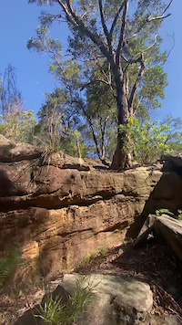
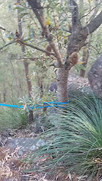
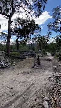
Photos of Hornsby Mountain Bike
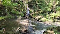
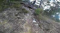
Videos of Hornsby Mountain Bike
trail: Tombstone
0:11 |
21 |
Feb 15, 2026
trail: Full X-Treem
0:09 |
181 |
Oct 11, 2023

trail: Excelsior Creek
0:23 |
31 |
Apr 14, 2023
trail: Darling Mills Creek link
0:17 |
33 |
Apr 14, 2023

trail: Boomer DH
0:57 |
56 |
May 19, 2022
trail: Mount Kuring-Gai DH
0:57 |
186 |
Sep 16, 2021
trail: Boomer DH
0:06 |
169 |
Jul 30, 2021

trail: Lyons' Den
3:55 |
213 |
May 11, 2021
Recent Trail Reports
| status | trail | date | condition | info | user |
|---|---|---|---|---|---|
| H2O-Exit Trail | Jun 13, 2026 @ 11:06am (Australia/Sydney) Jun 12, 2026 | Variable | MacroTiara | ||
| Five Coronas | Jun 13, 2026 @ 11:06am (Australia/Sydney) Jun 12, 2026 | Ideal | MacroTiara | ||
| Three Amigos | Jun 13, 2026 @ 11:06am (Australia/Sydney) Jun 12, 2026 | Ideal | MacroTiara | ||
| H2O-Blue Loop | Jun 13, 2026 @ 11:06am (Australia/Sydney) Jun 12, 2026 | Ideal | MacroTiara | ||
| Rock n Roll | Jun 13, 2026 @ 11:06am (Australia/Sydney) Jun 12, 2026 | Ideal | MacroTiara | ||
| H2O - Black Loop | Jun 13, 2026 @ 11:06am (Australia/Sydney) Jun 12, 2026 | Ideal | MacroTiara | ||
| Tetanus shot | Jun 13, 2026 @ 11:06am (Australia/Sydney) Jun 12, 2026 | Ideal | MacroTiara | ||
| Welcome to the Pleasure Dome | Jun 13, 2026 @ 11:06am (Australia/Sydney) Jun 12, 2026 | Variable | MacroTiara | ||
| Moto cruise | Jun 12, 2026 @ 1:19pm (Australia/Sydney) Jun 11, 2026 | Ideal | Chiggins07 | ||
| The Full Rumble | Jun 8, 2026 @ 5:24pm (Australia/Sydney) Jun 8, 2026 | Ideal | foxclock |
Activity Feed
| username | action | type | title | date |
|---|---|---|---|---|
| Bwai | wishlist | trail | activity #97175060 | Jun 17, 2026 @ 5:05am 22 hours |
| JAIKEN3zgo8t | ridden | trail | activity #96931374 | Jun 13, 2026 @ 6:20pm Jun 13, 2026 |
| MacroTiara | add | report | activity #96845874 and 7 more | Jun 12, 2026 @ 8:18pm Jun 12, 2026 |
| Chiggins07 | add | report | activity #96781544 | Jun 11, 2026 @ 8:19pm Jun 11, 2026 |
| Justinv5qoq3 | wishlist | trail | activity #96662528 and 1 more | Jun 10, 2026 @ 3:59am Jun 10, 2026 |
Recent Comments
| username | type | title | comment | date |
|---|---|---|---|---|
| trail | Nice fast trail. Good fun with good line... | Jun 8, 2026 @ 12:25am Jun 8, 2026 | ||
| trail | But more washed out than pictured, many more... | Jun 8, 2026 @ 12:22am Jun 8, 2026 | ||
| trail | Rocky, technical and more committed than blue.... | Jun 8, 2026 @ 12:20am Jun 8, 2026 | ||
| trail | its NOT a MTB trail, avoid. | Mar 22, 2026 @ 2:52am Mar 22, 2026 | ||
| trail | None of the videos linkedin here on trailforks... | Dec 30, 2025 @ 11:08pm Dec 30, 2025 |
Local Badges
-

10 Black Trails138 awarded -

Top 10 Trails0 awarded -

10 Green Trails276 awarded -

Completionist0 awarded -
Completionist0 awarded -
Completionist1 awarded
Bike & Skill Parks
| name | type | city | rating |
|---|---|---|---|
| Old Man's Valley Jump Park | skill park | Hornsby | |
| Montview Dirt Jumps | skill park | Hornsby |
Activity Type Stats
| activitytype | trails | distance | descent | descent distance | total vertical | rating | global rank | state rank | photos | reports | routes | ridelogs |
|---|---|---|---|---|---|---|---|---|---|---|---|---|
| Mountain Bike | 230 | 116 miles | 20,873 ft | 57 miles | 869 ft | #229 | #15 | 729 | 3,482 | 11 | 60,297 | |
| E-Bike | 124 | 72 miles | 11,322 ft | 35 miles | 853 ft | #953 | #65 | 3,033 | 6 | 5,059 | ||
| Gravel Bike | 1 | #140 | #92 | 226 | 42 | |||||||
| Horse | 3 | 2 miles | 308 ft | 1 mile | 427 ft | 407 | 2 | |||||
| Hike | 207 | 141 miles | 25,338 ft | 69 miles | 869 ft | #657 | #22 | 42 | 3,262 | 2 | 2,207 | |
| Trail Running | 200 | 137 miles | 23,809 ft | 67 miles | 869 ft | #719 | #27 | 3,258 | 1 | 2,452 |
Frequently Asked Questions About Hornsby
▼
What are the best places to ride in Hornsby?
Hornsby has 10 areas to explore for mountain biking. The top rated areas are:
▼
What are the highest rated mountain biking trails in Hornsby?
The highest rated mountain biking trails in Hornsby are:
- Lava Flow (4.5/5)
- Scratchy Arms DH (4.5/5)
- Boomer DH (4.4/5)
- Pool Downhill (4.4/5)
- H2O - Black Loop (4.3/5)
▼
What is the best time of the year to ride in Hornsby?
Based on ride log data, the most popular months to ride in Hornsby are:
- August (328 activities)
- July (309 activities)
- October (293 activities)
▼
Where can I park to ride in Hornsby?
There are 15 parking locations listed in Hornsby. The most popular parking spots are: View all parking and trailhead locations on the map to plan your visit.
Activities
Trails
- By Bartcaffinfinisar & contributors
- Admins: stuartrichardson, synergytrails, TrailCare
- #9793 - 18,985 views
- hornsby activity log | embed map of Hornsby mountain bike trails | hornsby mountain biking points of interest
Downloading of trail gps tracks in kml & gpx formats is enabled for Hornsby.
You must login to download files.