close
-
Layers w
- Weather Layers
- Pro
- Pro
- Pro
- Pro
- Pro
- Pro
- More Layers
- Pro
- Pro
- Pro
- Pro
-
Upgrade to

3D
Trail Conditions
- Unknown
- Snow Groomed
- Snow Packed
- Snow Covered
- Snow Cover Partial
- Freeze/thaw Cycle
- Icy
- Prevalent Mud
- Wet
- Variable
- Ideal
- Dry
- Very Dry
Trail Flow (Ridden Direction)
Trailforks scans users ridelogs to determine the most popular direction each trail is ridden. A good flowing trail network will have most trails flowing in a single direction according to their intension.
The colour categories are based on what percentage of riders are riding a trail in its intended direction.
The colour categories are based on what percentage of riders are riding a trail in its intended direction.
- > 96%
- > 90%
- > 80%
- > 70%
- > 50%
- < 50%
- bi-directional trail
- no data
Trail Last Ridden
Trailforks scans ridelogs to determine the last time a trail was ridden.
- < 2 days
- < 1 week
- < 2 weeks
- < 1 month
- < 6 months
- > 6 months
Trail Ridden Direction
The intended direction a trail should be ridden.
- Downhill Only
- Downhill Primary
- Both Directions
- Uphill Primary
- Uphill Only
- One Direction
Contribute Details
Colors indicate trail is missing specified detail.
- Description
- Photos
- Description & Photos
- Videos
Trail Popularity ?
Trailforks scans ridelogs to determine which trails are ridden the most in the last 9 months.
Trails are compared with nearby trails in the same city region with a possible 25 colour shades.
Think of this as a heatmap, more rides = more kinetic energy = warmer colors.
- most popular
- popular
- less popular
- not popular
ATV/ORV/OHV Filter
Max Vehicle Width
inches
US Cell Coverage
Legend

Radar Time
Activity Recordings
Trailforks uses anonymized public activity data.
?
Activity Recordings
Trailforks uses anonymized public activity data.
?
Personal Heatmap
▶
Activity Types
all
/
none
▶
Options
2
Date range
month
–
Winter Trails
Warning
A routing network for winter maps does not exist. Selecting trails using the winter trails layer has been disabled.
Missing Trails
Most Popular
Least Popular
Trails are colored based on popularity. The more popular a trail is, the more red. Less popular trails trend towards green.
Jump Magnitude Heatmap
Heatmap of where riders jump on trails. Zoom in to see individual jumps, click circles to view jump details.
BC Backroad Status
![map legend]()
Service Road Atlas is a free to use, community-driven service for viewing and creating reports on the numerous back-country service roads around B.C. and Alberta.

Slope Aspect
Direction the slope faces
Trails Deemphasized
Trails are shown in grey.
Only show trails with no bike usage.
Suggested Layers
Based on selected activity type
Save the current map location and zoom level as your default home location whenever this page is loaded.
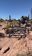
SaveTrail system near the Horse Thief campground off Highway 313. Several intertwined loops of mixed terrain; generally easier and quieter than the adjacent Navajo Rocks or Mag 7 trail systems.
Primary Trail Type: Cross-Country
eBikes Allowed:
No
Land Manager: BLM
 google parking directions
 Activities Click to view
- Mountain Bike
28 trails
- E-Bike
13 trails
- Hike
32 trails
- Trail Running
32 trails
Region Details
- 5
- 10
Region Status
Open as of May 25, 2026Local Trail Association
Stats
- Avg Trail Rating
- Trails (view details)
- 18
- Trails Mountain Bike
- 29
- Trails E-Bike
- 13
- Trails Adaptive Bike
- 7
- Trails Winter Fat Bike
- 9
- Trails Horse
- 2
- Trails Hike
- 32
- Trails Trail Running
- 32
- Total Distance
- 27 miles
- Total Descent
- 3,025 ft
- Total Vertical
- 718 ft
- Highest Trailhead
- 5,995 ft
- Reports
- 466
- Photos
- 95
- Ridden Counter
- 16,179
Popular Horsethief Mountain Biking Trails
• 90 ★ 4.0 • 8 miles • 489 ft • 2,372 •
NOTICE: Directional trail, ride clockwise. is 8.2 miles of trail that twists and turns through pinion and juniper trees, up and down rock ledges with long views looking out to the Henry Mountains. Note that there are no signed bail out...
• 75 ★ 4.1 • 7 miles • 281 ft • 1,438 •
Chisolm connects the Horsethief riding area to Navajo Rocks. It's a great mix of different types of trail, from bench cut dirt to open slickrock to built rock ramps to desert singletrack. It may seem flat, but there's a significant drop...
• 75 ★ 4.3 • 1 mile • 220 ft • 1,311 •
is the better of the two Whirlwind routes to come back up from . rides along an upper rocky rim with great singletrack riding and features, while goes down thru the basin and around on more open slickrock.
• 80 ★ 4.2 • 1 mile • 283 ft • 1,214 •
Trail work was done in 2025 to optimize many of the trails in Horsetheif. is recommended as a climb from North to South. Its a great trail developed by the local Moab Mix group. Trail has some fun features and sloped sandstone to...
• 90 ★ 2.0 • 1,027 ft • 12 ft • 1,052 •
Connects the Chisolm and trails to the Horsethief campground.
• 75 ★ 4.0 • 5,010 ft • 24 ft • 980 •
is a dual directional trail. Great option for connecting between Mustang and 7 up.
• 75 ★ 4.3 • 1 mile • 17 ft • 915 •
is a great downhill segment in the Horsethief System. Ride the trail from south to north for maximum fun! Rebuilt in 2025 the trail was optimized for downhill directionality and also removed any pinch points for handcycle riders...
Horsethief Mountain Bike Routes
★ 4.4 • 16 miles • 647 ft • 11 • Shuttled •
The Mag 5 ride is an awesome shuttle. The terrain is fairly intermediate and not super steep either....
★ 5.0 • 18 miles • 852 ft • 5 • Shuttled •
Great shuttle ride. 18-19 miles total, mostly downhill. Leave a vehicle at lower Navajo Rocks parking lot,...
★ 5.0 • 17 miles • 656 ft • 13 •
The Mag 5 ride is an awesome shuttle. The terrain is fairly intermediate and not super steep either....
★ 5.0 • 18 miles • 1,731 ft • 14 •
Extends bull run into Blue dot into Portal
Photos of Horsethief Mountain Bike
Videos of Horsethief Mountain Bike
trail: 7-up
0:04 |
35 |
Nov 25, 2025

trail: Mustang West
0:04 |
11 |
Nov 25, 2025
youtuber
![Mustang Loop]()
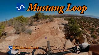
trail: Mustang East
13:21 |
17 |
May 10, 2026 , Moab
youtuber
![Whirlwind Loop]()

trail: Whirlwind East
13:21 |
14 |
May 8, 2026 , Moab
youtuber
![Great Intermediate MTB trail in Moab, UT -...]()

trail: Mustang West
13:21 |
41 |
May 8, 2026 , Moab
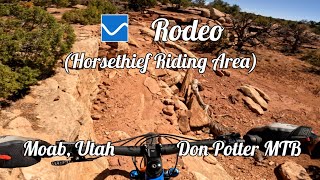
trail: Rodeo
1:11:18 |
83 |
Jan 24, 2026 , Moab
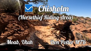
trail: Chisholm
48:05 |
57 |
Jan 17, 2026 , Moab
trail: Whirlwind West
15:41 |
43 |
Jan 10, 2026 , Moab
Recent Trail Reports
| status | trail | date | condition | info | user |
|---|---|---|---|---|---|
| Whirlwind West | May 25, 2026 @ 10:05am (America/Denver) May 25, 2026 | Unknown | tankersley | ||
| Bull Run (mid) | May 19, 2026 @ 9:05am (America/Denver) May 19, 2026 | Ideal | kardi13 TFSPAIN | ||
| Lasso | Apr 16, 2026 @ 1:51pm (America/Denver) Apr 16, 2026 | Dry | Cutlersales | ||
| Rodeo | Apr 4, 2026 @ 2:03pm (America/Denver) Apr 4, 2026 | Ideal | jahroo | ||
| Chisholm Campground Connector | Apr 4, 2026 @ 2:03pm (America/Denver) Apr 4, 2026 | Ideal | jahroo | ||
| Chisholm | Oct 30, 2025 @ 1:23pm (America/Denver) Oct 30, 2025 | Ideal | jahroo | ||
| Mustang West | Oct 30, 2025 @ 1:23pm (America/Denver) Oct 30, 2025 | Ideal | jahroo | ||
| Campground Connector | Oct 28, 2025 @ 12:23pm (America/Denver) Oct 28, 2025 | Ideal | jahroo | ||
| Wrangler CG Access | May 20, 2025 @ 2:54pm May 20, 2025 | Ideal | UtahJohn TRAILFORKS | ||
| Wrangler | May 20, 2025 @ 2:54pm May 20, 2025 | Ideal | UtahJohn TRAILFORKS |
Activity Feed
| username | action | type | title | date |
|---|---|---|---|---|
| F1schAZ | wishlist | route | activity #97018247 | Jun 14, 2026 @ 6:51pm Jun 14, 2026 |
| Pab80 | wishlist | route | activity #96929497 | Jun 13, 2026 @ 5:43pm Jun 13, 2026 |
| 6rdztI | wishlist | region | activity #96747822 | Jun 11, 2026 @ 10:38am Jun 11, 2026 |
| Deblayden | wishlist | region | activity #96728618 | Jun 11, 2026 @ 4:36am Jun 11, 2026 |
| lhatc | wishlist | route | activity #96316627 | Jun 5, 2026 @ 1:03pm Jun 5, 2026 |
Recent Comments
| username | type | title | comment | date |
|---|---|---|---|---|
| trail | Wish I never rode this trail. | Feb 16, 2026 @ 8:06pm Feb 16, 2026 | ||
| trail | Rode the mustang loop ccw. SUPER fun little... | Dec 6, 2025 @ 5:05pm Dec 6, 2025 | ||
| trail | Fun XC trail, it's a blue trail, but more of a... | Nov 4, 2025 @ 9:34pm Nov 4, 2025 | ||
| trail | Great XC trail ride several times from Horse... | Oct 23, 2025 @ 5:12pm Oct 23, 2025 | ||
| trail | Blue/green. Fun. First trail I ride after... | Oct 5, 2025 @ 1:55pm Oct 5, 2025 |
Nearby Areas
| name | distance | ||||
|---|---|---|---|---|---|
| Navajo Rocks | 8 | 3 km | |||
| Mag 7 | 2 | 10 | 4 | 2 | 6.7 km |
| Dead Horse Point | 5 | 8 | 1 | 6.9 km | |
| Moab Brand Trails | 11 | 11 | 4 | 1 | 7.6 km |
| Sovereign Trail System | 1 | 6 | 9 | 3 | 9.5 km |
Activity Type Stats
| activitytype | trails | distance | descent | descent distance | total vertical | rating | global rank | state rank | photos | reports | routes | ridelogs |
|---|---|---|---|---|---|---|---|---|---|---|---|---|
| Mountain Bike | 28 | 25 miles | 2,723 ft | 12 miles | 577 ft | #1,894 | #636 | 65 | 467 | 13 | 7,274 | |
| E-Bike | 13 | #7,669 | #2,290 | 9 | 347 | 1 | 234 | |||||
| Adaptive Bike | 7 | #784 | #400 | 1 | 1 | 2 | ||||||
| Winter Fat Bike | 9 | #786 | #403 | 1 | ||||||||
| Horse | 2 | 1 mile | 177 ft | 3,599 ft | 128 ft | 154 | 1 | |||||
| Hike | 32 | 27 miles | 3,025 ft | 13 miles | 719 ft | #3,000 | #1,034 | 20 | 467 | 1 | 242 | |
| Trail Running | 32 | 27 miles | 3,025 ft | 13 miles | 719 ft | #5,818 | #1,814 | 1 | 467 | 3 | 94 |
Frequently Asked Questions About Horsethief
▼
What are the highest rated mountain biking trails in Horsethief?
The highest rated mountain biking trails in Horsethief are:
- Whirlwind West (4.2/5)
- Hidalgo (4.2/5)
- Mustang East (4.2/5)
- Mustang West (4.1/5)
- Wildcat (4.1/5)
▼
What is the best time of the year to ride in Horsethief?
Based on ride log data, the most popular months to ride in Horsethief are:
- October (262 activities)
- April (134 activities)
- May (127 activities)
▼
Where can I park to ride in Horsethief?
There are 3 parking locations listed in Horsethief. The most popular parking spots are: View all parking and trailhead locations on the map to plan your visit.
▼
What is the longest trail in Horsethief?
The longest trail in Horsethief is Rodeo at 8.5 miles. View all trails sorted by distance.
Activities
Trails
- By canadaka
 Trailforks & contributors
 - Admins: MTM, MMBA, GrandCountyTrails
- #10414 - 20,919 views
- horsethief activity log | embed map of Horsethief mountain bike trails | horsethief mountain biking points of interest
Downloading of trail gps tracks in kml & gpx formats is enabled for Horsethief.
You must login to download files.