close
-
Layers w
- Weather Layers
- Pro
- Pro
- Pro
- Pro
- Pro
- Pro
- More Layers
- Pro
- Pro
- Pro
- Pro
-
Upgrade to

3D
Trail Conditions
- Unknown
- Snow Groomed
- Snow Packed
- Snow Covered
- Snow Cover Partial
- Freeze/thaw Cycle
- Icy
- Prevalent Mud
- Wet
- Variable
- Ideal
- Dry
- Very Dry
Trail Flow (Ridden Direction)
Trailforks scans users ridelogs to determine the most popular direction each trail is ridden. A good flowing trail network will have most trails flowing in a single direction according to their intension.
The colour categories are based on what percentage of riders are riding a trail in its intended direction.
The colour categories are based on what percentage of riders are riding a trail in its intended direction.
- > 96%
- > 90%
- > 80%
- > 70%
- > 50%
- < 50%
- bi-directional trail
- no data
Trail Last Ridden
Trailforks scans ridelogs to determine the last time a trail was ridden.
- < 2 days
- < 1 week
- < 2 weeks
- < 1 month
- < 6 months
- > 6 months
Trail Ridden Direction
The intended direction a trail should be ridden.
- Downhill Only
- Downhill Primary
- Both Directions
- Uphill Primary
- Uphill Only
- One Direction
Contribute Details
Colors indicate trail is missing specified detail.
- Description
- Photos
- Description & Photos
- Videos
Trail Popularity ?
Trailforks scans ridelogs to determine which trails are ridden the most in the last 9 months.
Trails are compared with nearby trails in the same city region with a possible 25 colour shades.
Think of this as a heatmap, more rides = more kinetic energy = warmer colors.
- most popular
- popular
- less popular
- not popular
ATV/ORV/OHV Filter
Max Vehicle Width
inches
US Cell Coverage
Legend

Radar Time
Activity Recordings
Trailforks uses anonymized public activity data.
?
Activity Recordings
Trailforks uses anonymized public activity data.
?
Personal Heatmap
▶
Activity Types
all
/
none
▶
Options
2
Date range
month
–
Winter Trails
Warning
A routing network for winter maps does not exist. Selecting trails using the winter trails layer has been disabled.
Missing Trails
Most Popular
Least Popular
Trails are colored based on popularity. The more popular a trail is, the more red. Less popular trails trend towards green.
Jump Magnitude Heatmap
Heatmap of where riders jump on trails. Zoom in to see individual jumps, click circles to view jump details.
BC Backroad Status
![map legend]()
Service Road Atlas is a free to use, community-driven service for viewing and creating reports on the numerous back-country service roads around B.C. and Alberta.

Slope Aspect
Direction the slope faces
Trails Deemphasized
Trails are shown in grey.
Only show trails with no bike usage.
Suggested Layers
Based on selected activity type
Save the current map location and zoom level as your default home location whenever this page is loaded.
Save
No description for Houghton has been added yet!
Login or register to submit one.
Activities Click to view
- Mountain Bike
74 trails
- E-Bike
74 trails
- Adaptive Bike
1 trails
- Hike
41 trails
- Trail Running
40 trails
- Dirtbike/Moto
5 trails
- ATV/ORV/OHV
5 trails
- Snowmobile
5 trails
- Snowshoe
35 trails
- Nordic Ski
41 trails
Region Details
- 7
- 1
- 19
- 16
- 8
Region Status
Open as of Jun 16, 2026Stats
- Avg Trail Rating
- Trails (view details)
- 83
- Trails Mountain Bike
- 74
- Trails E-Bike
- 74
- Trails Gravel Bike
- 7
- Trails Adaptive Bike
- 1
- Trails Hike
- 41
- Trails Trail Running
- 40
- Trails Dirtbike/Moto
- 5
- Trails ATV/ORV/OHV
- 5
- Trails Snowmobile
- 5
- Trails Snowshoe
- 35
- Trails Backcountry Ski
- 1
- Trails Nordic Ski
- 41
- Total Distance
- 84 miles
- Total Descent
- 4,385 ft
- Total Vertical
- 613 ft
- Highest Trailhead
- 1,216 ft
- Reports
- 356
- Photos
- 85
- Ridden Counter
- 9,291
Sub Regions
-
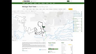
Michigan Tech Trails
- 18
- 15
- 8
-
Pilgrim Community Forest
- 1
Popular Houghton Mountain Biking Trails
• 100 ★ 4.4 • 1 mile • 28 ft • 416 •
Realativly flat trail featuring a handful of student built wooden features to test your balance and agility
• 90 ★ 4.7 • 4,272 ft • 21 ft • 372 •
Built by the wizards from Copper Harbor Trails Club, Sure Would Trail starts at the Michigan Tech Trails main trailhead, makes a very mellow 0.2 mile climb through a red pine plantation to the top of the property, then lets it all break...
• 100 ★ 4.5 • 2,631 ft • 5 ft • 321 •
Highly rated popular black diamond difficulty singletrack. This mountain bike primary trail can be used downhill only. It features berm, bridge and jump. Trail visibility is always easy to follow. On average it takes 3 minutes to complete this trail.
• 100 ★ 4.9 • 2,769 ft • 0 ft • 315 •
The biggest line at the Michigan Tech Trails, is a step up in jump size and commitment level from .
• 95 ★ 4.3 • 2,028 ft • 56 ft • 308 •
This loop starts with a short, steep, rooty climb to the right off . The climb moderates for a while, ascends one more short pitch, then turns left into a narrow, dry ravine and descends quickly down the floor, playing occasionally off...
• 80 ★ 4.8 • 1 mile • 207 ft • 251 •
The two-way section of Outer Limits branches off from the intersection of the and , at the bottom of the deep gorge created by Deadman's Creek. From here, the trail continues east a ways to the and Walkabout trails before turning north....
• 80 ★ 4.7 • 3,986 ft • 47 ft • 236 •
leaves at its high point and almost immediately begins dropping, carving sweeping turns through the woods before emptying into a long, flowing, fast field section before dropping again to the Pilgrim River. From the low point on the...
• 85 ★ 4.2 • 3,038 ft • 25 ft • 216 •
Yew Too as a loop is flat except for one small excursion into a small dry ravine. It winds through an extensive under story of Canadian yew under mature oaks and some white pine behind the neighborhoods on Royalwood Street and Mill...
Houghton Mountain Bike Routes
★ 5.0 • 2 miles • 239 ft • 4 • Loop •
The Flow Ride starts at the main trailhead. Just follow the yellow arrows to complete this ride. You start...
★ 4.0 • 6 miles • 141 ft • 0 • Loop •
This ride incorporates the challenging wooden features of and and the natural rock and water features of...
10 miles • 687 ft • 9 • Loop •
Michigan Tech mountain bike trails. Mixture of intermediate to very difficult terrain.
5 miles • 162 ft • 17 •
This easy loop is a great place to start riding singletrack. The corridor is 8 feet wide, so there's...
★ 3.0 • 11 miles • 1,059 ft • 14 • Loop •
This ride ties together all the fast, flowy downhills and big climb singletrack at the Tech trails. Narrow...
• 4 miles • 558 ft • 0 •
Photos of Houghton Mountain Bike
Videos of Houghton Mountain Bike
featured
![Don't Think - Michigan Tech Trails in Houghton, MI]()

trail: Don't Think
0:01 |
80 |
Nov 2, 2025 , Houghton

trail: Don't Think
0:43 |
253 |
Aug 24, 2022

trail: Don't Think
0:43 |
|
Aug 24, 2022

trail: Just Mite
2:16 |
234 |
Sep 16, 2023 , Houghton

trail: Hairy Toad Loop
2:13 |
792 |
Oct 8, 2020 , Houghton
trail: Time Trial
0:52 |
429 |
Oct 5, 2020 , Houghton

2:05 |
46 |
Nov 23, 2025 , Houghton

2:27 |
19 |
Nov 23, 2025
Current Trail Warnings
| status | trail | date | condition | user | info |
|---|---|---|---|---|---|
| Ring Loop | Jun 2, 2026 @ 11:42am (America/Detroit) Jun 2, 2026 | Unknown | edawg25420 | Eroding Bridge |
Recent Trail Reports
Activity Feed
| username | action | type | title | date |
|---|---|---|---|---|
| zawilk | ridden | route | activity #97276901 | Jun 18, 2026 @ 2:42pm 1 day |
| zawilk | vote | route | activity #97276899 | Jun 18, 2026 @ 2:42pm 1 day |
| zawilk | add | route | activity #97276868 | Jun 18, 2026 @ 2:41pm 1 day |
| zawilk | add | report | activity #97147122 and 2 more | Jun 16, 2026 @ 4:51pm Jun 16, 2026 |
| ftgeib | add | photo | activity #97007372 and 3 more | Jun 14, 2026 @ 3:03pm Jun 14, 2026 |
Recent Comments
| username | type | title | comment | date |
|---|---|---|---|---|
| trail | Old school techy and tough. Fun and... | Oct 26, 2025 @ 8:56am Oct 26, 2025 | ||
| trail | A relic of bygone times. Your long low slack... | Oct 26, 2025 @ 8:55am Oct 26, 2025 | ||
| trail | Old school xc jank | Sep 1, 2025 @ 11:42am Sep 1, 2025 | ||
| trail | 4-5 well built jumps, a couple are gaps but so... | Sep 1, 2025 @ 11:41am Sep 1, 2025 | ||
| trail | You were riding thru peoples back yards | Jul 11, 2023 @ 12:42pm Jul 11, 2023 |
Local Badges
-

Top 10 Trails11 awarded -

Descent 100k Badge1 awarded -

Big Ride 30k520 awarded -

Epic Ride 50k178 awarded -

Descent 10k Badge24 awarded -

Completionist1 awarded
Bike & Skill Parks
| name | type | city | rating |
|---|---|---|---|
| Pump Track | skill park | Houghton | |
| Pump Track | skill park | Houghton | |
| Beginner Skills Area | skill park | Houghton |
Local Mountain Biking Directory
-
Copper Country Cycling Club
![Copper Country Cycling Club]()
-
Rhythm Bike ShopBike Shop
![Rhythm Bike Shop]()
-
Down Wind SportsBike Shop
![Down Wind Sports]()
Activity Type Stats
| activitytype | trails | distance | descent | descent distance | total vertical | rating | global rank | state rank | photos | reports | routes | ridelogs |
|---|---|---|---|---|---|---|---|---|---|---|---|---|
| Mountain Bike | 74 | 69 miles | 3,196 ft | 29 miles | 614 ft | #1,931 | #701 | 76 | 354 | 5 | 7,543 | |
| E-Bike | 74 | 69 miles | 3,196 ft | 29 miles | 614 ft | #2,115 | #942 | 207 | 5 | 178 | ||
| Gravel Bike | 7 | 41 miles | 768 ft | 18 miles | 614 ft | #878 | #482 | 22 | 14 | |||
| Adaptive Bike | 1 | 4 miles | 49 ft | 4,134 ft | 49 ft | #410 | #1,754 | 1 | 1 | |||
| Hike | 41 | 66 miles | 2,677 ft | 27 miles | 614 ft | #1,088 | #499 | 330 | 338 | |||
| Trail Running | 40 | 66 miles | 2,677 ft | 27 miles | 614 ft | #3,150 | #918 | 330 | 658 | |||
| Dirtbike/Moto | 5 | 31 miles | 686 ft | 16 miles | 610 ft | #751 | #265 | 21 | 1 | |||
| ATV/ORV/OHV | 5 | 31 miles | 686 ft | 16 miles | 610 ft | #557 | #205 | 23 | 1 | |||
| Snowmobile | 5 | 31 miles | 686 ft | 16 miles | 610 ft | #208 | #96 | 14 | ||||
| Snowshoe | 35 | 27 miles | 2,415 ft | 11 miles | 397 ft | #521 | #189 | 24 | 28 | |||
| Backcountry Ski | 1 | 2 miles | 295 ft | 4,846 ft | 92 ft | 3 | 51 | |||||
| Nordic Ski | 41 | 20 miles | 1,437 ft | 8 miles | 361 ft | #73 | #20 | 8 | 75 | 2 | 1,831 |
Frequently Asked Questions About Houghton
▼
What are the best places to ride in Houghton?
Houghton has 2 areas to explore for mountain biking. The top rated areas are:
▼
What are the highest rated mountain biking trails in Houghton?
The highest rated mountain biking trails in Houghton are:
- Sure Wood Trail (4.4/5)
- Don't Think (4.4/5)
- Outer Limits Loop (4.4/5)
- Just Mite (4.2/5)
- Gonzo Trail (4.2/5)
▼
What is the best time of the year to ride in Houghton?
Based on ride log data, the most popular months to ride in Houghton are:
- July (118 activities)
- September (75 activities)
- October (62 activities)
▼
Where can I park to ride in Houghton?
There are 6 parking locations listed in Houghton. The most popular parking spots are:
- Tech Trails Main Trailhead
- Tolkien Trails Trailhead
- Nara Trailhead
- Mill Road Trailhead
- Softball Fields Trailhead
Activities
Trails
- By WanderingMan
 BSMTB & contributors
 - Admins: NCT-PWC, CCCC
- #6187 - 9,309 views
- houghton activity log | embed map of Houghton mountain bike trails | houghton mountain biking points of interest
Downloading of trail gps tracks in kml & gpx formats is enabled for Houghton.
You must login to download files.