close
-
Layers w
- Weather Layers
- Pro
- Pro
- Pro
- Pro
- Pro
- Pro
- More Layers
- Pro
- Pro
- Pro
- Pro
-
Upgrade to

3D
Trail Conditions
- Unknown
- Snow Groomed
- Snow Packed
- Snow Covered
- Snow Cover Partial
- Freeze/thaw Cycle
- Icy
- Prevalent Mud
- Wet
- Variable
- Ideal
- Dry
- Very Dry
Trail Flow (Ridden Direction)
Trailforks scans users ridelogs to determine the most popular direction each trail is ridden. A good flowing trail network will have most trails flowing in a single direction according to their intension.
The colour categories are based on what percentage of riders are riding a trail in its intended direction.
The colour categories are based on what percentage of riders are riding a trail in its intended direction.
- > 96%
- > 90%
- > 80%
- > 70%
- > 50%
- < 50%
- bi-directional trail
- no data
Trail Last Ridden
Trailforks scans ridelogs to determine the last time a trail was ridden.
- < 2 days
- < 1 week
- < 2 weeks
- < 1 month
- < 6 months
- > 6 months
Trail Ridden Direction
The intended direction a trail should be ridden.
- Downhill Only
- Downhill Primary
- Both Directions
- Uphill Primary
- Uphill Only
- One Direction
Contribute Details
Colors indicate trail is missing specified detail.
- Description
- Photos
- Description & Photos
- Videos
Trail Popularity ?
Trailforks scans ridelogs to determine which trails are ridden the most in the last 9 months.
Trails are compared with nearby trails in the same city region with a possible 25 colour shades.
Think of this as a heatmap, more rides = more kinetic energy = warmer colors.
- most popular
- popular
- less popular
- not popular
ATV/ORV/OHV Filter
Max Vehicle Width
inches
US Cell Coverage
Legend

Radar Time
Activity Recordings
Trailforks uses anonymized public activity data.
?
Activity Recordings
Trailforks uses anonymized public activity data.
?
Personal Heatmap
▶
Activity Types
all
/
none
▶
Options
2
Date range
month
–
Winter Trails
Warning
A routing network for winter maps does not exist. Selecting trails using the winter trails layer has been disabled.
Missing Trails
Most Popular
Least Popular
Trails are colored based on popularity. The more popular a trail is, the more red. Less popular trails trend towards green.
Jump Magnitude Heatmap
Heatmap of where riders jump on trails. Zoom in to see individual jumps, click circles to view jump details.
BC Backroad Status
![map legend]()
Service Road Atlas is a free to use, community-driven service for viewing and creating reports on the numerous back-country service roads around B.C. and Alberta.

Slope Aspect
Direction the slope faces
Trails Deemphasized
Trails are shown in grey.
Only show trails with no bike usage.
Suggested Layers
Based on selected activity type
Save the current map location and zoom level as your default home location whenever this page is loaded.
Save
No description for Hurricane has been added yet!
Login or register to submit one.
Activities Click to view
- Mountain Bike
215 trails
- E-Bike
60 trails
- Gravel Bike
0 trails
- Adaptive Bike
0 trails
- Winter Fat Bike
0 trails
- Horse
47 trails
- Hike
265 trails
- Trail Running
252 trails
- Dirtbike/Moto
36 trails
- ATV/ORV/OHV
32 trails
Region Details
- 56
- 3
- 40
- 62
- 44
- 4
- 1
Region Status
Open as of Jun 7, 2026Stats
- Avg Trail Rating
- Trails (view details)
- 287
- Trails Mountain Bike
- 215
- Trails E-Bike
- 60
- Trails Horse
- 47
- Trails Hike
- 265
- Trails Trail Running
- 252
- Trails Dirtbike/Moto
- 36
- Trails Observed Trials
- 1
- Trails ATV/ORV/OHV
- 32
- Total Distance
- 519 miles
- Total Descent
- 64,073 ft
- Total Vertical
- 7,695 ft
- Highest Trailhead
- 10,369 ft
- Reports
- 3,874
- Photos
- 2,296
- Ridden Counter
- 182,735
Articles

Destination Showcase - Greater Zion, UT
Jan 4, 2022 from pinkbike.com
Everything you need to know before you head to the Greater Zion area in Southwestern Utah.
Sub Regions
-
Boy Scout Trails
- 4
- 9
- 6
- 1
-
Confluence Park
- 4
- 5
-
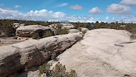
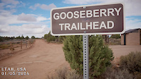
Gooseberry Mesa
- 3
- 8
- 5
-
Grafton Mesa
- 4
- 7
- 2
-
Hurricane Cliffs
- 1
- 9
- 10
- 6
-
Little Creek Mountain
- 6
- 1
-
Red Cliffs BLM National Conservation Area
- 2
- 8
- 2
-
Red Cliffs BLM National Conservation Area-Sand Cove Unit
- 1
- 2
- 2
-
Warner Valley
- 2
- 1
-
Wire Mesa
- 4
- 2
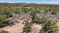
Popular Hurricane Mountain Biking Trails
• 100 ★ 4.0 • 448 ft • 4 ft • 5,263 •
Tight loose switchbacks, once navigated you can hit the bottom fast and let her rip
• 100 ★ 4.4 • 2,270 ft • 62 ft • 5,037 •
A real mix of boulder climbing and rock hopping. Try not to endo on the return rock drop, someone in the group always seems to. The is the popular place for groups rides to get a group photo
• 100 ★ 4.3 • 2,762 ft • 0 ft • 4,995 •
This is the continuation of the Downhill only section of that takes you through a sandy wash. After you drop off the sketchy canyon edge, you rip down through the high walls of the wash. It moves fast and fun until you reach the...
• 100 ★ 4.1 • 1,893 ft • 0 ft • 4,705 •
Can't beat the view from the top of the trail. This entry section is pretty simple and fast. The trail quickly hits an intimidating technical section (noted in the red) but it is totally rideable. This section is Downhill only from the...
• 100 ★ 4.1 • 2,415 ft • 28 ft • 4,148 •
This the downhill only section that starts off at the parking lot and takes you to the road. Smooth winding singletrack with some really interesting shale rock formations and mini-cliffs that you ride next to. This part can flow pretty...
• 95 ★ 4.4 • 1 mile • 22 ft • 4,140 •
is a section of mildly technical slick rock riding. The trail serves as a gateway to and the Trail. Follow the white dots and you're good to go!
• 95 ★ 4.7 • 5 miles • 785 ft • 3,865 •
is some fun Slick Rock riding. Follow the dots and you're good.
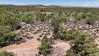
Hurricane Mountain Bike Routes
★ 4.0 • 11 miles • 733 ft • 16 • Loop •
This is my go-to loop in Gooseberry Mesa. Start off with some rolling slickrock on then warm up to the...
★ 4.7 • 11 miles • 817 ft • 1 • Loop •
This is a great family friendly route that is a good way to introduce your kids or new rider to the fun of...
★ 5.0 • 11 miles • 775 ft • 5 • Loop •
Starting at the road where first crosses, ride southeast on and climb to the top of the mesa and hook a...
★ 3.0 • 24 miles • 2,223 ft • 8 •
This is a big loop! There are lots of punchy ups and some steady climbs, so don't think that it's a mellow...
★ 5.0 • 8 miles • 557 ft • 7 • Out & Back •
Ride (a portion of it) to then back out.
★ 5.0 • 8 miles • 591 ft • 5 • Loop •
This is the 2017 Intermountain Cup Cactus Hugger Race route for one lap.
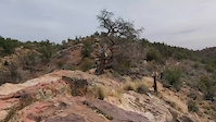
Photos of Hurricane Mountain Bike
Videos of Hurricane Mountain Bike

trail: Hurricane Rim
0:47 |
2 |
Apr 27, 2026

trail: Practice
0:20 |
11 |
Feb 10, 2026
trail: Practice
0:20 |
8 |
Nov 18, 2025

trail: South Rim
3:31 |
27 |
Nov 1, 2024
trail: South Rim
3:31 |
|
Nov 1, 2024
trail: Wire Mesa
0:51 |
52 |
Apr 30, 2024
trail: Wire Mesa
0:51 |
|
Apr 30, 2024
trail: More Money
0:12 |
53 |
Mar 13, 2024
Recent Trail Reports
| status | trail | date | condition | info | user |
|---|---|---|---|---|---|
| South Rim | Jun 3, 2026 @ 7:35am (America/Denver) Jun 3, 2026 | Ideal | Smithbelair | ||
| Gooseberry Point | Jun 3, 2026 @ 7:35am (America/Denver) Jun 3, 2026 | Ideal | Smithbelair | ||
| Yellow, Extended | Jun 3, 2026 @ 7:35am (America/Denver) Jun 3, 2026 | Ideal | Smithbelair | ||
| Windmill Alt | Jun 3, 2026 @ 7:35am (America/Denver) Jun 3, 2026 | Ideal | Smithbelair | ||
| Windmill | Jun 3, 2026 @ 7:35am (America/Denver) Jun 3, 2026 | Ideal | Smithbelair | ||
| Cryptobionic | May 30, 2026 @ 8:00am (America/Phoenix) May 30, 2026 | Ideal | sdcnaples | ||
| Undisclosed (Middle) | May 9, 2026 @ 10:51am (America/Denver) May 9, 2026 | Unknown | dirtgomer | ||
| Carne Asada | May 2, 2026 @ 10:20am (America/Denver) May 2, 2026 | Very Dry | frizbee-luke | ||
| Jem (Lower) | May 2, 2026 @ 10:20am (America/Denver) May 2, 2026 | Very Dry | frizbee-luke | ||
| Goosebumps A-Line | May 2, 2026 @ 10:20am (America/Denver) May 2, 2026 | Very Dry | frizbee-luke |
Activity Feed
| username | action | type | title | date |
|---|---|---|---|---|
| Jojogris1 | wishlist | trail | activity #97382797 | Jun 20, 2026 @ 5:01am 1 day |
| mzielinski96 | wishlist | route | activity #97272363 | Jun 18, 2026 @ 1:12pm 3 days |
| KeithKP5iRp | wishlist | route | activity #97149092 | Jun 16, 2026 @ 5:17pm Jun 16, 2026 |
| ShirleydCLJv1 | wishlist | trail | activity #97089746 and 1 more | Jun 15, 2026 @ 11:19pm Jun 15, 2026 |
| rebecahanrahan | wishlist | trail | activity #97082718 | Jun 15, 2026 @ 7:23pm Jun 15, 2026 |
Recent Comments
| username | type | title | comment | date |
|---|---|---|---|---|
| trail | Great addition so you don’t have to take... | Jun 7, 2026 @ 2:12pm Jun 7, 2026 | ||
| trail | Edit | May 15, 2026 @ 2:31pm May 15, 2026 | ||
| trail | 140/160 Hello TF. When can we exit post? | May 15, 2026 @ 2:30pm May 15, 2026 | ||
| trail | Super fun and best smiles per mile in area.... | May 15, 2026 @ 2:30pm May 15, 2026 | ||
| trail | Cool | May 6, 2026 @ 1:37pm May 6, 2026 |
Local Badges
-

Top 10 Trails32 awarded -

Descent 100k Badge11 awarded -

Big Ride 30k5,566 awarded -

Epic Ride 50k1,208 awarded -

Completionist0 awarded -
Completionist0 awarded
Bike & Skill Parks
| name | type | city | rating |
|---|---|---|---|
| Hurricane Bike Park | skill park | Hurricane |
Activity Type Stats
| activitytype | trails | distance | descent | descent distance | total vertical | rating | global rank | state rank | photos | reports | routes | ridelogs |
|---|---|---|---|---|---|---|---|---|---|---|---|---|
| Mountain Bike | 215 | 311 miles | 33,114 ft | 137 miles | 6,135 ft | #92 | #35 | 2,157 | 3,863 | 60 | 83,764 | |
| E-Bike | 60 | 126 miles | 11,680 ft | 62 miles | 2,769 ft | #783 | #760 | 8 | 3,113 | 3 | 5,451 | |
| Horse | 47 | 71 miles | 7,375 ft | 34 miles | 5,974 ft | #174 | #405 | 16 | 717 | 11 | ||
| Hike | 265 | 418 miles | 55,151 ft | 183 miles | 7,694 ft | #120 | #69 | 84 | 3,868 | 2 | 5,679 | |
| Trail Running | 252 | 404 miles | 50,387 ft | 179 miles | 7,694 ft | #164 | #71 | 14 | 3,868 | 2 | 2,212 | |
| Dirtbike/Moto | 36 | 116 miles | 10,098 ft | 49 miles | 2,582 ft | #39 | #21 | 18 | 712 | 2 | 303 | |
| Observed Trials | 1 | 4 miles | 180 ft | 2 miles | 115 ft | 2 | 2 | 16 | ||||
| ATV/ORV/OHV | 32 | 102 miles | 8,268 ft | 42 miles | 2,582 ft | #24 | #16 | 7 | 671 | 1 | 224 |
Frequently Asked Questions About Hurricane
▼
What are the best places to ride in Hurricane?
Hurricane has 11 areas to explore for mountain biking. The top rated areas are:
▼
What are the highest rated mountain biking trails in Hurricane?
The highest rated mountain biking trails in Hurricane are:
- Hidden Canyon (4.9/5)
- South Rim (4.7/5)
- Wire Mesa (4.6/5)
- Grafton Mesa (4.6/5)
- North Loop (4.6/5)
▼
What is the best time of the year to ride in Hurricane?
Based on ride log data, the most popular months to ride in Hurricane are:
- October (1,292 activities)
- April (1,203 activities)
- November (1,045 activities)
▼
Where can I park to ride in Hurricane?
There are 54 parking locations listed in Hurricane. The most popular parking spots are:
- Sheep Bridge Trailhead
- Gooseberry Mesa (White Trail) Parking and Restrooms
- Wire Mesa Trailhead
- Parking
- Jem Trailhead
Activities
Trails
Points of Interest
- Hurricane Cliffs Campsite 54 Camping
- Hurricane Cliffs Campsite 26 Camping
- Hurricane Cliffs Campsite 1 Camping
- Hurricane Cliffs Campsite 34 Camping
- Hurricane Cliffs Campsite 41 Camping
- Hurricane Cliffs Campsite 48 Camping
- Hurricane Cliffs Campsite 47 Camping
- Hurricane Cliffs Campsite 21 Camping
- Hurricane Cliffs Campsite 27 Camping
- Hurricane Cliffs Campsite 22 Camping
- Signal Peak (10,361 ft)
- Burger Peak (10,285 ft)
- Big Point (10,000 ft)
- By canadaka
 Trailforks & contributors
 - Admins: SUBA
- #4730 - 90,750 views
- hurricane activity log | embed map of Hurricane mountain bike trails | hurricane mountain biking points of interest
Downloading of trail gps tracks in kml & gpx formats is enabled for Hurricane.
You must login to download files.