close
-
Layers w
- Weather Layers
- Pro
- Pro
- Pro
- Pro
- Pro
- Pro
- More Layers
- Pro
- Pro
- Pro
- Pro
-
Upgrade to

3D
Trail Conditions
- Unknown
- Snow Groomed
- Snow Packed
- Snow Covered
- Snow Cover Partial
- Freeze/thaw Cycle
- Icy
- Prevalent Mud
- Wet
- Variable
- Ideal
- Dry
- Very Dry
Trail Flow (Ridden Direction)
Trailforks scans users ridelogs to determine the most popular direction each trail is ridden. A good flowing trail network will have most trails flowing in a single direction according to their intension.
The colour categories are based on what percentage of riders are riding a trail in its intended direction.
The colour categories are based on what percentage of riders are riding a trail in its intended direction.
- > 96%
- > 90%
- > 80%
- > 70%
- > 50%
- < 50%
- bi-directional trail
- no data
Trail Last Ridden
Trailforks scans ridelogs to determine the last time a trail was ridden.
- < 2 days
- < 1 week
- < 2 weeks
- < 1 month
- < 6 months
- > 6 months
Trail Ridden Direction
The intended direction a trail should be ridden.
- Downhill Only
- Downhill Primary
- Both Directions
- Uphill Primary
- Uphill Only
- One Direction
Contribute Details
Colors indicate trail is missing specified detail.
- Description
- Photos
- Description & Photos
- Videos
Trail Popularity ?
Trailforks scans ridelogs to determine which trails are ridden the most in the last 9 months.
Trails are compared with nearby trails in the same city region with a possible 25 colour shades.
Think of this as a heatmap, more rides = more kinetic energy = warmer colors.
- most popular
- popular
- less popular
- not popular
ATV/ORV/OHV Filter
Max Vehicle Width
inches
US Cell Coverage
Legend

Radar Time
Activity Recordings
Trailforks uses anonymized public activity data.
?
Activity Recordings
Trailforks uses anonymized public activity data.
?
Personal Heatmap
▶
Activity Types
all
/
none
▶
Options
2
Date range
month
–
Winter Trails
Warning
A routing network for winter maps does not exist. Selecting trails using the winter trails layer has been disabled.
Missing Trails
Most Popular
Least Popular
Trails are colored based on popularity. The more popular a trail is, the more red. Less popular trails trend towards green.
Jump Magnitude Heatmap
Heatmap of where riders jump on trails. Zoom in to see individual jumps, click circles to view jump details.
BC Backroad Status
![map legend]()
Service Road Atlas is a free to use, community-driven service for viewing and creating reports on the numerous back-country service roads around B.C. and Alberta.

Slope Aspect
Direction the slope faces
Trails Deemphasized
Trails are shown in grey.
Only show trails with no bike usage.
Suggested Layers
Based on selected activity type
Save the current map location and zoom level as your default home location whenever this page is loaded.
Save
No description for Hyvinkää has been added yet!
Login or register to submit one.
Activities Click to view
- Mountain Bike
377 trails
- E-Bike
370 trails
- Adaptive Bike
0 trails
- Winter Fat Bike
0 trails
- Hike
376 trails
- Trail Running
376 trails
Region Details
- 39
- 64
- 182
- 74
- 15
- 3
Region Status
Caution as of Oct 31, 2025Stats
- Avg Trail Rating
- Trails (view details)
- 377
- Trails Mountain Bike
- 377
- Trails E-Bike
- 370
- Trails Hike
- 376
- Trails Trail Running
- 376
- Total Distance
- 172 miles
- Total Descent
- 7,130 ft
- Total Vertical
- 289 ft
- Highest Trailhead
- 525 ft
- Reports
- 10
- Photos
- 1
- Ridden Counter
- 1,127
Sub Regions
-
Erkylä
- 44
- 118
- 29
- 2
-
Hyvinkää Pohjoinen
- 2
Popular Hyvinkää Mountain Biking Trails
• 100 ★ 0.0 • 3,596 ft • 12 ft • 24 •
Trail with technical rocky sections and some flowy downhill parts
• 100 ★ 0.0 • 2,579 ft • 16 ft • 11 •
Popular green difficulty singletrack. This mountain bike primary trail can be used both directions. On average it takes 6 minutes to complete this trail.
• 100 ★ 0.0 • 3,796 ft • 32 ft • 10 •
Popular green difficulty singletrack. This mountain bike primary trail can be used both directions. On average it takes 8 minutes to complete this trail.
• 95 ★ 0.0 • 1,765 ft • 3 ft • 9 •
Popular green difficulty singletrack. This mountain bike primary trail can be used both directions. On average it takes 2 minutes to complete this trail.
• 100 ★ 0.0 • 2,687 ft • 34 ft • 9 •
Popular white difficulty singletrack. This mountain bike primary trail can be used both directions. On average it takes 3 minutes to complete this trail.
• 95 ★ 0.0 • 1 mile • 25 ft • 9 •
Popular white difficulty singletrack. This mountain bike primary trail can be used both directions. On average it takes 7 minutes to complete this trail.
• 90 ★ 0.0 • 2,513 ft • 32 ft • 8 •
Popular green difficulty singletrack. This mountain bike primary trail can be used both directions. On average it takes 3 minutes to complete this trail.
• 95 ★ 0.0 • 1,801 ft • 16 ft • 8 •
Popular green difficulty singletrack. This mountain bike primary trail can be used both directions. On average it takes 7 minutes to complete this trail.
Hyvinkää Mountain Bike Routes
VO2 max Norjalainen 29km Loop Featured
18 miles • 571 ft • 10 • Loop •
Norwegian VO2 max of 4x4min intervals with 3 minute rest in terrain. Heart rate around 90%. Rest below...
25 miles • 903 ft • 28 • Loop •
4 about 4km about 12 minute Super Segments on an ebike. Elite riders on a normal bike probably a few...
ErkyläSpeedways Featured
30 miles • 1,019 ft • 17 • Loop •
The easiest and fastest sections of Erkylä. Tour through the best fast flowing trails of the area. Couple...
16 miles • 510 ft • 1 • Loop •
XC route going around the best trails including the Erkylä mountainbiking route. Very easy mostly. Easier...
15 miles • 496 ft • 13 • Loop •
6 short sprint options. Sprint 2, 3 and 4 are the steep ones you can sink big watts into. 1, 5 and 6 are...
22 miles • 667 ft • 21 • Loop •
Best trails of Erkylä for 2024. Mostly very easy constantly turning forest trail with almost no difficult...
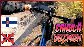
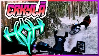
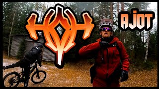
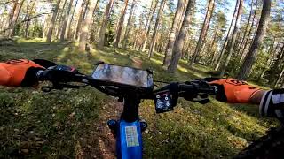
Videos of Hyvinkää Mountain Bike
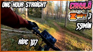
59:23 |
66 |
Dec 16, 2024
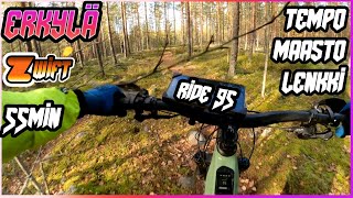
56:05 |
62 |
Nov 4, 2024
trail: Käsipuittenmäki Linkkitorni
22:59 |
109 |
May 10, 2024 , Hyvinkää
trail: Erkylä MidLine
15:58 |
118 |
Nov 27, 2023 , Hyvinkää
6:04 |
76 |
Oct 31, 2023
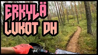
trail: Erkylä LukotEK
2:40 |
135 |
Sep 25, 2023 , Hyvinkää
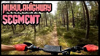
trail: Oitti MukulaHighway
4:33 |
67 |
Sep 22, 2023 , Hyvinkää
trail: Lallu 100mutkaa
0:55 |
87 |
Sep 22, 2023 , Hyvinkää
Recent Trail Reports
| status | trail | date | condition | info | user |
|---|---|---|---|---|---|
| Hyvinkää singeltrack & jumps | Jul 18, 2023 @ 5:38am Jul 18, 2023 | Dry | Railpuffin | ||
| Simon enskapätkä | Sep 13, 2020 @ 12:51am Sep 13, 2020 | Wet | Keisari |
Activity Feed
| username | action | type | title | date |
|---|---|---|---|---|
| Timo5FpUEZ | wishlist | route | activity #91801523 | Apr 2, 2026 @ 9:50pm Apr 2, 2026 |
| LassiLqTCz7 | wishlist | trail | activity #78341308 and 2 more | Aug 17, 2025 @ 9:00am Aug 17, 2025 |
| LassiLqTCz7 | wishlist | trail | activity #78127733 and 5 more | Aug 14, 2025 @ 12:22pm Aug 14, 2025 |
| talitintti666 | add | trail | activity #76969415 and 3 more | Jul 29, 2025 @ 11:25am Jul 29, 2025 |
| talitintti666 | add | trail | activity #76969403 | Jul 29, 2025 @ 11:24am Jul 29, 2025 |
Recent Comments
| username | type | title | comment | date |
|---|---|---|---|---|
| trail | "No trespassing" and "beware of the dog" signs... | Jun 6, 2023 @ 12:28pm Jun 6, 2023 |
Local Badges
-

10 Blue Trails2 awarded -

10 Green Trails14 awarded -

Epic Mountain Bike Climb 2k0 awarded -

Climbing 10k Badge0 awarded -

Mountain Biking 100k Badge0 awarded -

Epic Ride Descent 2k0 awarded
Bike & Skill Parks
| name | type | city | rating |
|---|---|---|---|
| Hyvinkää pump track | skill park | Hyvinkää |
Activity Type Stats
| activitytype | trails | distance | descent | descent distance | total vertical | rating | global rank | state rank | photos | reports | routes | ridelogs |
|---|---|---|---|---|---|---|---|---|---|---|---|---|
| Mountain Bike | 377 | 172 miles | 7,129 ft | 57 miles | 289 ft | #524 | #7 | 1 | 10 | 14 | 682 | |
| E-Bike | 370 | 166 miles | 6,795 ft | 56 miles | 289 ft | #340 | #8 | 8 | 12 | 155 | ||
| Hike | 376 | 171 miles | 7,126 ft | 57 miles | 289 ft | #644 | #7 | 10 | 25 | |||
| Trail Running | 376 | 171 miles | 7,126 ft | 57 miles | 289 ft | #449 | #7 | 10 | 8 |
Frequently Asked Questions About Hyvinkää
▼
What are the best places to ride in Hyvinkää?
Hyvinkää has 2 areas to explore for mountain biking. The top rated areas are:
▼
What are the highest rated mountain biking trails in Hyvinkää?
The highest rated mountain biking trails in Hyvinkää are:
- Erkylä EskonOikkariYlä (4.1/5)
- Erkylä LukotEK (4.1/5)
- Usmi Gräveli1 (0/5)
- Lentokenttä RutikanPoimut (0/5)
- EK 3 (0/5)
▼
What is the best time of the year to ride in Hyvinkää?
Based on ride log data, the most popular months to ride in Hyvinkää are:
- July (8 activities)
- November (3 activities)
- August (2 activities)
▼
Where can I park to ride in Hyvinkää?
There are 5 parking locations listed in Hyvinkää. The most popular parking spots are: View all parking and trailhead locations on the map to plan your visit.
Activities
Trails
- By jaatuli & contributors
- Admins: Bunabe
- #19923 - 2,718 views
- hyvinkää activity log | embed map of Hyvinkää mountain bike trails | hyvinkää mountain biking points of interest
Downloading of trail gps tracks in kml & gpx formats is enabled for Hyvinkää.
You must login to download files.