close
-
Layers w
- Weather Layers
- Pro
- Pro
- Pro
- Pro
- Pro
- Pro
- More Layers
- Pro
- Pro
- Pro
- Pro
-
Upgrade to

3D
Trail Conditions
- Unknown
- Snow Groomed
- Snow Packed
- Snow Covered
- Snow Cover Partial
- Freeze/thaw Cycle
- Icy
- Prevalent Mud
- Wet
- Variable
- Ideal
- Dry
- Very Dry
Trail Flow (Ridden Direction)
Trailforks scans users ridelogs to determine the most popular direction each trail is ridden. A good flowing trail network will have most trails flowing in a single direction according to their intension.
The colour categories are based on what percentage of riders are riding a trail in its intended direction.
The colour categories are based on what percentage of riders are riding a trail in its intended direction.
- > 96%
- > 90%
- > 80%
- > 70%
- > 50%
- < 50%
- bi-directional trail
- no data
Trail Last Ridden
Trailforks scans ridelogs to determine the last time a trail was ridden.
- < 2 days
- < 1 week
- < 2 weeks
- < 1 month
- < 6 months
- > 6 months
Trail Ridden Direction
The intended direction a trail should be ridden.
- Downhill Only
- Downhill Primary
- Both Directions
- Uphill Primary
- Uphill Only
- One Direction
Contribute Details
Colors indicate trail is missing specified detail.
- Description
- Photos
- Description & Photos
- Videos
Trail Popularity ?
Trailforks scans ridelogs to determine which trails are ridden the most in the last 9 months.
Trails are compared with nearby trails in the same city region with a possible 25 colour shades.
Think of this as a heatmap, more rides = more kinetic energy = warmer colors.
- most popular
- popular
- less popular
- not popular
ATV/ORV/OHV Filter
Max Vehicle Width
inches
US Cell Coverage
Legend

Radar Time
Activity Recordings
Trailforks uses anonymized public activity data.
?
Activity Recordings
Trailforks uses anonymized public activity data.
?
Personal Heatmap
▶
Activity Types
all
/
none
▶
Options
2
Date range
month
–
Winter Trails
Warning
A routing network for winter maps does not exist. Selecting trails using the winter trails layer has been disabled.
Missing Trails
Most Popular
Least Popular
Trails are colored based on popularity. The more popular a trail is, the more red. Less popular trails trend towards green.
Jump Magnitude Heatmap
Heatmap of where riders jump on trails. Zoom in to see individual jumps, click circles to view jump details.
BC Backroad Status
![map legend]()
Service Road Atlas is a free to use, community-driven service for viewing and creating reports on the numerous back-country service roads around B.C. and Alberta.

Slope Aspect
Direction the slope faces
Trails Deemphasized
Trails are shown in grey.
Only show trails with no bike usage.
Suggested Layers
Based on selected activity type
Save the current map location and zoom level as your default home location whenever this page is loaded.
SaveThe trails around Ibra city and old town
AKA: Sharqiya
Land Status: Crown Land
Region Supporters & Maintainers
![]()
ROY LUNETABuilder
Activities Click to view
- Mountain Bike
11 trails
- E-Bike
6 trails
- Hike
8 trails
- Trail Running
8 trails
Region Details
- 6
- 2
- 2
- 1
Region Status
Open as of Dec 8, 2022Local Trail Association
Stats
- Avg Trail Rating
- Trails (view details)
- 11
- Trails Mountain Bike
- 11
- Trails E-Bike
- 6
- Trails Hike
- 8
- Trails Trail Running
- 8
- Total Distance
- 16 miles
- Total Descent
- 1,279 ft
- Total Vertical
- 310 ft
- Highest Trailhead
- 1,719 ft
- Reports
- 5
- Photos
- 11
- Ridden Counter
- 29
Popular Ibra Mountain Biking Trails
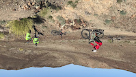
• 5 ★ 4.0 • 1,174 ft • 3 ft • 13 •
A couple of turns, and then the jump - a 3m gap over a wadi, with an intimidating wall on the other side. make sure you scope it out first!
• 5 ★ 4.0 • 6 miles • 653 ft • 12 •
A singletrack line through the hills around Ibra. Steep at times, with optional jumps and drops, but there are ride arounds for the most scary stuff.
• 5 ★ 4.0 • 1 mile • 102 ft • 1 •
A tour of the Ibra old town, through the narrow streets of the ruins and past the farms and date plantations.
• 5 ★ 0.0 • 3,047 ft • 110 ft •
A donkey trail leading to the play area and second half of the trail.
• 5 ★ 4.0 • 4,271 ft • 118 ft •
The play loop off , with berms and steep climbs to test your skills and power
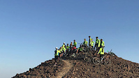
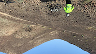
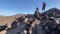
Photos of Ibra Mountain Bike
Videos of Ibra Mountain Bike
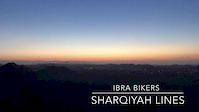
trail: Sharqiya lines
0:01 |
10 |
Feb 22, 2022
trail: Roy's Jumpline
0:10 |
12 |
Feb 22, 2022
trail: Sharqiya lines
0:05 |
25 |
Feb 22, 2022
trail: Sharqiya lines
0:16 |
17 |
Feb 8, 2021
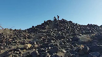
trail: Sharqiya lines
0:11 |
7 |
Feb 8, 2021
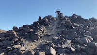
trail: Sharqiya lines
0:18 |
11 |
Feb 8, 2021
trail: Sharqiya lines
4:55 |
392 |
Dec 16, 2017
Recent Trail Reports
| status | trail | date | condition | info | user |
|---|---|---|---|---|---|
| Sharqiya lines | Feb 22, 2022 @ 2:16am Feb 22, 2022 | Dry | Roysluneta | ||
| Roy's Jumpline | May 9, 2018 @ 8:15am May 9, 2018 | Dry | magedansary |
Activity Feed
| username | action | type | title | date |
|---|---|---|---|---|
| joebunn | vote | trail | activity #43196481 and 3 more | Aug 21, 2023 @ 4:21am Aug 21, 2023 |
| Roysluneta | add | report | activity #27029659 | Feb 22, 2022 @ 2:19am Feb 22, 2022 |
| royluneta | add | photo | activity #24689899 and 1 more | Nov 7, 2021 @ 9:00pm Nov 7, 2021 |
| royluneta | add | photo | activity #24581113 and 1 more | Nov 3, 2021 @ 10:47pm Nov 3, 2021 |
| royluneta | comment | report | activity #16983492 | Mar 2, 2021 @ 8:02pm Mar 2, 2021 |
Recent Comments
| username | type | title | comment | date |
|---|---|---|---|---|
| report | My bad, edited out the roots hahaha | Mar 2, 2021 @ 8:02pm Mar 2, 2021 | ||
| report | Roots? I'll be there shortly to ride them! | Mar 2, 2021 @ 7:58am Mar 2, 2021 | ||
| trail | I wish to ride this the next time I am in ibra | Jul 27, 2018 @ 2:04am Jul 27, 2018 |
Nearby Areas
| name | distance | ||||
|---|---|---|---|---|---|
| Daykah | 1 | 34.1 km |
Activity Type Stats
| activitytype | trails | distance | descent | descent distance | total vertical | rating | global rank | state rank | photos | reports | routes | ridelogs |
|---|---|---|---|---|---|---|---|---|---|---|---|---|
| Mountain Bike | 11 | 16 miles | 1,280 ft | 6 miles | 312 ft | #4,137 | #8 | 9 | 5 | 99 | ||
| E-Bike | 6 | 7 miles | 180 ft | 2 miles | 144 ft | #1,478 | #6 | 2 | 2 | 1 | ||
| Hike | 8 | 9 miles | 266 ft | 3 miles | 151 ft | #2,104 | #7 | 2 | 12 | |||
| Trail Running | 8 | 9 miles | 266 ft | 3 miles | 151 ft | #1,417 | #6 | 2 |
Frequently Asked Questions About Ibra
▼
What are the highest rated mountain biking trails in Ibra?
The highest rated mountain biking trails in Ibra are:
- Sharqiya lines (4/5)
- Roy's Jumpline (4/5)
- Ibra Old Town Trail (4/5)
- Sharqiya Playground (4/5)
- Donkey Path (0/5)
▼
What is the best time of the year to ride in Ibra?
Based on ride log data, the most popular months to ride in Ibra are:
- June (5 activities)
- February (2 activities)
- July (1 activities)
▼
Where can I park to ride in Ibra?
Check the Ibra trail map for trailhead and parking information. Community members regularly update access and parking details for trails in the area.
▼
What is the longest trail in Ibra?
The longest trail in Ibra is Sharqiya lines at 5.6 miles. View all trails sorted by distance.
- ibra activity log | embed map of Ibra mountain bike trails |
Downloading of trail gps tracks in kml & gpx formats is enabled for Ibra.
You must login to download files.