close
-
Layers w
- Weather Layers
- Pro
- Pro
- Pro
- Pro
- Pro
- Pro
- More Layers
- Pro
- Pro
- Pro
- Pro
-
Upgrade to

3D
Trail Conditions
- Unknown
- Snow Groomed
- Snow Packed
- Snow Covered
- Snow Cover Partial
- Freeze/thaw Cycle
- Icy
- Prevalent Mud
- Wet
- Variable
- Ideal
- Dry
- Very Dry
Trail Flow (Ridden Direction)
Trailforks scans users ridelogs to determine the most popular direction each trail is ridden. A good flowing trail network will have most trails flowing in a single direction according to their intension.
The colour categories are based on what percentage of riders are riding a trail in its intended direction.
The colour categories are based on what percentage of riders are riding a trail in its intended direction.
- > 96%
- > 90%
- > 80%
- > 70%
- > 50%
- < 50%
- bi-directional trail
- no data
Trail Last Ridden
Trailforks scans ridelogs to determine the last time a trail was ridden.
- < 2 days
- < 1 week
- < 2 weeks
- < 1 month
- < 6 months
- > 6 months
Trail Ridden Direction
The intended direction a trail should be ridden.
- Downhill Only
- Downhill Primary
- Both Directions
- Uphill Primary
- Uphill Only
- One Direction
Contribute Details
Colors indicate trail is missing specified detail.
- Description
- Photos
- Description & Photos
- Videos
Trail Popularity ?
Trailforks scans ridelogs to determine which trails are ridden the most in the last 9 months.
Trails are compared with nearby trails in the same city region with a possible 25 colour shades.
Think of this as a heatmap, more rides = more kinetic energy = warmer colors.
- most popular
- popular
- less popular
- not popular
ATV/ORV/OHV Filter
Max Vehicle Width
inches
US Cell Coverage
Legend

Radar Time
Activity Recordings
Trailforks uses anonymized public activity data.
?
Activity Recordings
Trailforks uses anonymized public activity data.
?
Personal Heatmap
▶
Activity Types
all
/
none
▶
Options
2
Date range
month
–
Winter Trails
Warning
A routing network for winter maps does not exist. Selecting trails using the winter trails layer has been disabled.
Missing Trails
Most Popular
Least Popular
Trails are colored based on popularity. The more popular a trail is, the more red. Less popular trails trend towards green.
Jump Magnitude Heatmap
Heatmap of where riders jump on trails. Zoom in to see individual jumps, click circles to view jump details.
BC Backroad Status
![map legend]()
Service Road Atlas is a free to use, community-driven service for viewing and creating reports on the numerous back-country service roads around B.C. and Alberta.

Slope Aspect
Direction the slope faces
Trails Deemphasized
Trails are shown in grey.
Only show trails with no bike usage.
Suggested Layers
Based on selected activity type
Save the current map location and zoom level as your default home location whenever this page is loaded.
Save
No description for Imittos Mountain has been added yet!
Login or register to submit one.
 google parking directions
Primary Trail Type: All-Mountain & Downhill
Shuttleable: YES
AKA: Imittos
google parking directionsThis region uses the Uk/Euro style trail grading system.
Activities Click to view
- Mountain Bike
282 trails
- E-Bike
279 trails
- Hike
252 trails
- Trail Running
254 trails
- Dirtbike/Moto
22 trails
Region Details
- 31
- 2
- 95
- 79
- 5
Region Status
Caution as of Jun 12, 2026Stats
- Avg Trail Rating
- Trails (view details)
- 247
- Trails Mountain Bike
- 282
- Trails E-Bike
- 279
- Trails Hike
- 252
- Trails Trail Running
- 254
- Trails Dirtbike/Moto
- 22
- Trails Observed Trials
- 2
- Trails ATV/ORV/OHV
- 1
- Trails Downhill Ski
- 2
- Trails Backcountry Ski
- 2
- Total Distance
- 111 miles
- Total Descent
- 47,178 ft
- Total Vertical
- 2,731 ft
- Highest Trailhead
- 2,913 ft
- Reports
- 2,071
- Photos
- 236
- Ridden Counter
- 14,282
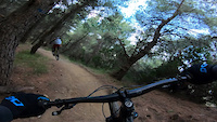
Popular Imittos Mountain Mountain Biking Trails
• 100 ★ 4.7 • 1,870 ft • 6 ft • 359 •
This is a trail built by Hellenic Mountain Bike Association members. Fairy easy, with nice features (berms and a couple of jumps). Fast trail that connects to a couple more trails in the area. Bonus feature are the ancient ruins of the...
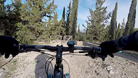
• 100 ★ 4.7 • 1,368 ft • 3 ft • 337 •
An easy flow trail. Tight berms, dusty surface and small jumps. If you ride it and you combined it with '' '' trail is one one a the best and more fun trails in Imittos.
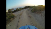
• 100 ★ 4.6 • 1,798 ft • 0 ft • 260 •
This trail features berms, 2 bit jumps and drops. It's mostly a flow trail but can be hard.
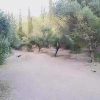
• 100 ★ 4.0 • 561 ft • 0 ft • 252 •
Popular green difficulty singletrack. This mountain bike primary trail can be used downhill only and has a easy overall physical rating with a 0 ft green climb. Trail visibility is always easy to follow. On average it takes minutes to complete this trail.
• 100 ★ 4.8 • 2,766 ft • 0 ft • 240 •
Highly rated popular green difficulty singletrack. This mountain bike primary trail can be used downhill only and has a moderate overall physical rating. It features berm, drop, jump and rock face. Trail visibility is always easy to follow. On average it takes 4 minutes to complete this trail.
Imittos Mountain Mountain Bike Routes
15 miles • 3,564 ft • 17 • Loop •
25km loop, 17 trails, 1000m Taxiarhes-Trizato-Red-Lagos Yperokeanio ( -karavara-Yperokeanio) Ypovrixio...
• 13 miles • 2,448 ft • 20 •
• 13 miles • 1,555 ft • 12 •
• 14 miles • 2,744 ft • 7 •
• 9 miles • 2,643 ft • 11 •
• 7 miles • 2,135 ft • 15 •
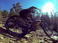
Photos of Imittos Mountain Mountain Bike
Videos of Imittos Mountain Mountain Bike


Recent Trail Reports
| status | trail | date | condition | info | user |
|---|---|---|---|---|---|
| Tres-Long | Jun 12, 2026 @ 7:13pm (Europe/Athens) Jun 12, 2026 | Dry | unkindled | ||
| YoSoDa | Jun 12, 2026 @ 7:13pm (Europe/Athens) Jun 12, 2026 | Dry | unkindled | ||
| Dasos | Jun 12, 2026 @ 7:13pm (Europe/Athens) Jun 12, 2026 | Dry | unkindled | ||
| MX Trail | May 25, 2026 @ 12:46pm (Europe/Athens) May 25, 2026 | Ideal | ThanasisSt | ||
| Eripia Trail | May 25, 2026 @ 12:46pm (Europe/Athens) May 25, 2026 | Dry | ThanasisSt | ||
| Avenue de compresseur | May 25, 2026 @ 12:46pm (Europe/Athens) May 25, 2026 | Ideal | ThanasisSt | ||
| Red Fox Trail | Apr 15, 2026 @ 3:42pm (Europe/Athens) Apr 15, 2026 | Ideal | unkindled | ||
| Drop Trail | Apr 13, 2026 @ 3:22pm (Europe/Athens) Apr 13, 2026 | Ideal | unkindled | ||
| Untwisted | Mar 29, 2026 @ 3:57pm (Europe/Athens) Mar 29, 2026 | Ideal | unkindled | ||
| Lagos trail | Mar 29, 2026 @ 3:57pm (Europe/Athens) Mar 29, 2026 | Ideal | unkindled |
Activity Feed
| username | action | type | title | date |
|---|---|---|---|---|
| Kokor4OwcB | wishlist | trail | activity #97312943 | Jun 19, 2026 @ 6:36am 2 days |
| vileda | wishlist | trail | activity #97244843 | Jun 18, 2026 @ 5:22am Jun 18, 2026 |
| unkindled | add | report | activity #96973310 and 2 more | Jun 14, 2026 @ 8:43am Jun 14, 2026 |
| Fv8UFZ | ridden | trail | activity #96150529 | Jun 3, 2026 @ 6:23am Jun 3, 2026 |
| AbsCJBjE | wishlist | region | activity #95920799 | May 31, 2026 @ 3:14am May 31, 2026 |
Recent Comments
| username | type | title | comment | date |
|---|---|---|---|---|
| trail | Δεν είναι μπλε. Παρά πολύ... | May 21, 2026 @ 8:26am May 21, 2026 | ||
| trail | Really bad condition, very deep trail due to... | Mar 25, 2026 @ 2:05am Mar 25, 2026 | ||
| trail | It is not in good condition due to water... | Mar 22, 2026 @ 9:12am Mar 22, 2026 | ||
| trail | The trail I would say is a fair blue but not... | Nov 4, 2025 @ 9:41pm Nov 4, 2025 | ||
| trail | Really cool trail not hard at all I would say... | Nov 4, 2025 @ 9:39pm Nov 4, 2025 |
Nearby Areas
| name | distance | ||||
|---|---|---|---|---|---|
| Alsos Veikou | 11 | 1 | 4.7 km | ||
| Alsos Ktimatos Siggrou | 4 | 1 | 7.2 km | ||
| Penteli | 7.5 km | ||||
| Penteli Mountain | 1 | 7.6 km | |||
| Penteli | 1 | 8.6 km |
Local Badges
-

Completionist0 awarded
Bike & Skill Parks
| name | type | city | rating |
|---|---|---|---|
| Papagos Trails | skill park | Athens | |
| Glyka Nera Jumps | skill park | Athens |
Activity Type Stats
| activitytype | trails | distance | descent | descent distance | total vertical | rating | global rank | state rank | photos | reports | routes | ridelogs |
|---|---|---|---|---|---|---|---|---|---|---|---|---|
| Mountain Bike | 282 | 104 miles | 42,516 ft | 75 miles | 2,733 ft | #142 | #1 | 233 | 2,071 | 1 | 17,205 | |
| E-Bike | 279 | 105 miles | 43,245 ft | 75 miles | 2,733 ft | #141 | #5 | 2 | 1,769 | 2,431 | ||
| Hike | 252 | 103 miles | 40,640 ft | 74 miles | 2,733 ft | #238 | #2 | 1 | 1,984 | 583 | ||
| Trail Running | 254 | 103 miles | 40,846 ft | 75 miles | 2,733 ft | #150 | #3 | 1,991 | 1,137 | |||
| Dirtbike/Moto | 22 | 14 miles | 3,901 ft | 11 miles | 2,267 ft | #194 | #2 | 262 | 1 | |||
| Observed Trials | 2 | 2,362 ft | 62 ft | 1,001 ft | 49 ft | 4 | ||||||
| ATV/ORV/OHV | 1 | 3,589 ft | 98 ft | 3,114 ft | 98 ft | 246 | ||||||
| Downhill Ski | 2 | 5 | ||||||||||
| Backcountry Ski | 2 |
Frequently Asked Questions About Imittos Mountain
▼
What are the highest rated mountain biking trails in Imittos Mountain?
The highest rated mountain biking trails in Imittos Mountain are:
- Dasos (4.6/5)
- Yperokeanio (4.5/5)
- 10 Trail (4.5/5)
- Ponstan (4.5/5)
- Tres-Long (4.5/5)
▼
What is the best time of the year to ride in Imittos Mountain?
Based on ride log data, the most popular months to ride in Imittos Mountain are:
- December (102 activities)
- May (96 activities)
- October (88 activities)
▼
Where can I park to ride in Imittos Mountain?
There are 8 parking locations listed in Imittos Mountain. The most popular parking spots are: View all parking and trailhead locations on the map to plan your visit.
▼
What is the longest trail in Imittos Mountain?
The longest trail in Imittos Mountain is Avenue de compresseur at 4.0 km. View all trails sorted by distance.
Activities
Trails
Points of Interest
- By dimitrisz & contributors
- Admins: apply
- #4112 - 28,472 views
- imittos mountain activity log | embed map of Imittos Mountain mountain bike trails | imittos mountain mountain biking points of interest
Downloading of trail gps tracks in kml & gpx formats is enabled for Imittos Mountain.
You must login to download files.