close
-
Layers w
- Weather Layers
- Pro
- Pro
- Pro
- Pro
- Pro
- Pro
- More Layers
- Pro
- Pro
- Pro
- Pro
-
Upgrade to

3D
Trail Conditions
- Unknown
- Snow Groomed
- Snow Packed
- Snow Covered
- Snow Cover Partial
- Freeze/thaw Cycle
- Icy
- Prevalent Mud
- Wet
- Variable
- Ideal
- Dry
- Very Dry
Trail Flow (Ridden Direction)
Trailforks scans users ridelogs to determine the most popular direction each trail is ridden. A good flowing trail network will have most trails flowing in a single direction according to their intension.
The colour categories are based on what percentage of riders are riding a trail in its intended direction.
The colour categories are based on what percentage of riders are riding a trail in its intended direction.
- > 96%
- > 90%
- > 80%
- > 70%
- > 50%
- < 50%
- bi-directional trail
- no data
Trail Last Ridden
Trailforks scans ridelogs to determine the last time a trail was ridden.
- < 2 days
- < 1 week
- < 2 weeks
- < 1 month
- < 6 months
- > 6 months
Trail Ridden Direction
The intended direction a trail should be ridden.
- Downhill Only
- Downhill Primary
- Both Directions
- Uphill Primary
- Uphill Only
- One Direction
Contribute Details
Colors indicate trail is missing specified detail.
- Description
- Photos
- Description & Photos
- Videos
Trail Popularity ?
Trailforks scans ridelogs to determine which trails are ridden the most in the last 9 months.
Trails are compared with nearby trails in the same city region with a possible 25 colour shades.
Think of this as a heatmap, more rides = more kinetic energy = warmer colors.
- most popular
- popular
- less popular
- not popular
ATV/ORV/OHV Filter
Max Vehicle Width
inches
US Cell Coverage
Legend

Radar Time
Activity Recordings
Trailforks uses anonymized public activity data.
?
Activity Recordings
Trailforks uses anonymized public activity data.
?
Personal Heatmap
▶
Activity Types
all
/
none
▶
Options
2
Date range
month
–
Winter Trails
Warning
A routing network for winter maps does not exist. Selecting trails using the winter trails layer has been disabled.
Missing Trails
Most Popular
Least Popular
Trails are colored based on popularity. The more popular a trail is, the more red. Less popular trails trend towards green.
Jump Magnitude Heatmap
Heatmap of where riders jump on trails. Zoom in to see individual jumps, click circles to view jump details.
BC Backroad Status
![map legend]()
Service Road Atlas is a free to use, community-driven service for viewing and creating reports on the numerous back-country service roads around B.C. and Alberta.

Slope Aspect
Direction the slope faces
Trails Deemphasized
Trails are shown in grey.
Only show trails with no bike usage.
Suggested Layers
Based on selected activity type
Save the current map location and zoom level as your default home location whenever this page is loaded.
Save
No description for Indianapolis has been added yet!
Login or register to submit one.
Activities Click to view
- Mountain Bike
71 trails
- Gravel Bike
0 trails
- Adaptive Bike
0 trails
- Winter Fat Bike
0 trails
- Horse
14 trails
- Hike
98 trails
- Trail Running
98 trails
Region Details
- 18
- 1
- 27
- 13
- 4
- 1
Region Status
Caution as of Jun 6, 2026Stats
- Avg Trail Rating
- Trails (view details)
- 111
- Trails Mountain Bike
- 71
- Trails Horse
- 14
- Trails Hike
- 98
- Trails Trail Running
- 98
- Total Distance
- 81 miles
- Total Descent
- 2,526 ft
- Total Vertical
- 291 ft
- Highest Trailhead
- 937 ft
- Reports
- 2,796
- Photos
- 150
- Ridden Counter
- 9,728
Sub Regions
-
Fort Harrison State Park
- 4
- 2
-
Indy Cycloplex
-
Southwestway Park
- 7
- 7
- 1
-
The Headquarters MTB Skills Park @ Washington Park
- 1
- 13
- 3
- 3
- 1
-
Town Run Trail Park
- 3
- 1
Popular Indianapolis Mountain Biking Trails
• 100 ★ 4.1 • 2 miles • 49 ft • 431 •
The is on land donated by Oliver Daugherty to the Central Indiana Land Trust. The trail in a recreation easement thanks to Oliver Daugherty. The area was historically used to quarry sand. Sections are in woods, but much of the look is...
• 100 ★ 4.0 • 2 miles • 5 ft • 416 •
This section of Town Run is a long the white river and twists and turns through a wooded floodplain. The trail is directional, with the direction changing by day. Please look at the directional signs at the trail head.
• 100 ★ 5.0 • 1,657 ft • 15 ft • 408 •
This is a short section between Talking Tree and the 465 Bridge. If twists through a wooded area along the White River. The trail is directional by day. Please look at the directional signage at intersections.
• 95 ★ 4.5 • 1,522 ft • 24 ft • 407 •
Popular blue difficulty singletrack. This mountain bike primary trail can be used one direction. It features drop. Trail visibility is always easy to follow. On average it takes 2 minutes to complete this trail.
• 90 ★ 5.0 • 2 miles • 29 ft • 398 •
Popular green difficulty singletrack. This mountain bike primary trail can be used one direction and has a moderate overall physical rating with a 29 ft green climb. It features berm and drop. Trail visibility is always easy to follow. On average it takes 13 minutes to complete this trail.
• 75 ★ 3.7 • 4 miles • 410 ft • 360 •
Intermediate skill level trail with technical climbs along ravines, roots, and a long flowy downhill section towards the end.
• 80 ★ 4.3 • 1 mile • 79 ft • 359 •
Nice relaxing loop around the base of Mann Hill. Parts run along the side of the hill. MIld grades allow some decent speed to be achieved in some sections while avoiding any difficult climbing. All users allowed
• 95 ★ 4.0 • 1,998 ft • 0 ft • 345 •
An intense rock garden leads to a string of tabletops before exiting the woods into the powerline easement. Here, more tabletops, broken up by a number of sweeping berms, lead down the hill to yet more tabletops, a series of...
Indianapolis Mountain Bike Routes
★ 3.4 • 7 miles • 99 ft • 8 • Loop •
The full loop consisting of the north and south ends of Town Run Trail Park.
7 miles • 112 ft • 5 • Loop •
Town Run is directional now by day. Check trail signage to determine which direction. I think it runs...
• 19 miles • 378 ft • 7 •
• 13 miles • 951 ft • 20 •
• 18 miles • 1,303 ft • 13 •
Photos of Indianapolis Mountain Bike
Videos of Indianapolis Mountain Bike
trail: Big Fire North
0:48 |
147 |
Nov 20, 2021

trail: Big Fire South
3:08 |
155 |
Nov 20, 2021

trail: Power Line DH
0:33 |
298 |
Nov 20, 2021

trail: Power Line DH
0:40 |
453 |
Sep 28, 2015
youtuber
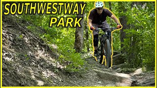
![Southwestway Park is a Mini Downhill Park |...]()

8:05 |
264 |
Mar 25, 2024
youtuber
![Southwestway Park is a Mini Downhill Park |...]()
8:05 |
144 |
Mar 24, 2024
Current Trail Warnings
| status | trail | date | condition | user | info |
|---|---|---|---|---|---|
| Camp Glenn | Jun 2, 2026 @ 1:46pm (America/Indiana/Indianapolis) Jun 2, 2026 | Ideal | chuckalouie |
Recent Trail Reports
Activity Feed
| username | action | type | title | date |
|---|---|---|---|---|
| ScottKtKoqs | wishlist | route | activity #96546719 and 1 more | Jun 8, 2026 @ 9:53am Jun 8, 2026 |
| chuckalouie | add | report | activity #96407398 and 3 more | Jun 6, 2026 @ 2:40pm Jun 6, 2026 |
| MarkYwhWOt | ridden | trail | activity #96265483 | Jun 4, 2026 @ 5:47pm Jun 4, 2026 |
| chuckalouie | add | report | activity #96113522 | Jun 2, 2026 @ 3:31pm Jun 2, 2026 |
| donharder | add | report | activity #96052523 and 3 more | Jun 1, 2026 @ 5:37pm Jun 1, 2026 |
Recent Comments
| username | type | title | comment | date |
|---|---|---|---|---|
| report | Forgot to mention there is a down tree | Dec 4, 2022 @ 11:02am Dec 4, 2022 | ||
| report | Oh!!! Also the grass has been trimmed on the... | Jul 24, 2021 @ 7:41am Jul 24, 2021 | ||
| report | Trimmed back grass on 4 power line trail... | Jun 6, 2021 @ 3:07pm Jun 6, 2021 | ||
| report | Where are these trails? | Apr 18, 2021 @ 5:16pm Apr 18, 2021 | ||
| trail | Awesome trail. Super technical rock garden... | Apr 18, 2021 @ 8:35am Apr 18, 2021 |
Local Badges
-

10 Green Trails237 awarded -

Epic Ride Climb 2k8 awarded -

Climbing 10k Badge58 awarded -

Climbing 100k Badge0 awarded -

Epic Ride Descent 2k8 awarded -

Descent 10k Badge58 awarded
Bike & Skill Parks
| name | type | city | rating |
|---|---|---|---|
| The Headquarters Mountain Bike Skills Park | skill park | Indianapolis | |
| Indy Cycloplex BMX / Skate Park | skill park | Indianapolis | |
| Lake Sullivan BMX Track | skill park | Indianapolis |
Activity Type Stats
| activitytype | trails | distance | descent | descent distance | total vertical | rating | global rank | state rank | photos | reports | routes | ridelogs |
|---|---|---|---|---|---|---|---|---|---|---|---|---|
| Mountain Bike | 71 | 71 miles | 2,228 ft | 20 miles | 285 ft | #946 | #372 | 136 | 2,796 | 3 | 26,498 | |
| Horse | 14 | 9 miles | 367 ft | 3 miles | 200 ft | #1,637 | #937 | 211 | ||||
| Hike | 98 | 80 miles | 2,244 ft | 21 miles | 292 ft | #2,054 | #865 | 2,776 | 857 | |||
| Trail Running | 98 | 80 miles | 2,244 ft | 21 miles | 292 ft | #1,146 | #415 | 14 | 2,776 | 901 |
Frequently Asked Questions About Indianapolis
▼
What are the best places to ride in Indianapolis?
Indianapolis has 6 areas to explore for mountain biking. The top rated areas are:
▼
What are the highest rated mountain biking trails in Indianapolis?
The highest rated mountain biking trails in Indianapolis are:
- Big Fire North (4.3/5)
- Big Fire South (4.3/5)
- Talking Tree North to End (4.2/5)
- Upper Cottonwood (4.2/5)
- Talking Tree to 465 (4.1/5)
▼
What is the best time of the year to ride in Indianapolis?
Based on ride log data, the most popular months to ride in Indianapolis are:
- July (210 activities)
- August (186 activities)
- September (180 activities)
▼
Where can I park to ride in Indianapolis?
There are 19 parking locations listed in Indianapolis. The most popular parking spots are: View all parking and trailhead locations on the map to plan your visit.
Activities
Trails
- By jpmerz & contributors
- Admins: 21Steve65, HMBA
- #5412 - 12,236 views
- indianapolis activity log | embed map of Indianapolis mountain bike trails | indianapolis mountain biking points of interest
Downloading of trail gps tracks in kml & gpx formats is enabled for Indianapolis.
You must login to download files.