close
-
Layers w
- Weather Layers
- Pro
- Pro
- Pro
- Pro
- Pro
- Pro
- More Layers
- Pro
- Pro
- Pro
- Pro
-
Upgrade to

3D
Trail Conditions
- Unknown
- Snow Groomed
- Snow Packed
- Snow Covered
- Snow Cover Partial
- Freeze/thaw Cycle
- Icy
- Prevalent Mud
- Wet
- Variable
- Ideal
- Dry
- Very Dry
Trail Flow (Ridden Direction)
Trailforks scans users ridelogs to determine the most popular direction each trail is ridden. A good flowing trail network will have most trails flowing in a single direction according to their intension.
The colour categories are based on what percentage of riders are riding a trail in its intended direction.
The colour categories are based on what percentage of riders are riding a trail in its intended direction.
- > 96%
- > 90%
- > 80%
- > 70%
- > 50%
- < 50%
- bi-directional trail
- no data
Trail Last Ridden
Trailforks scans ridelogs to determine the last time a trail was ridden.
- < 2 days
- < 1 week
- < 2 weeks
- < 1 month
- < 6 months
- > 6 months
Trail Ridden Direction
The intended direction a trail should be ridden.
- Downhill Only
- Downhill Primary
- Both Directions
- Uphill Primary
- Uphill Only
- One Direction
Contribute Details
Colors indicate trail is missing specified detail.
- Description
- Photos
- Description & Photos
- Videos
Trail Popularity ?
Trailforks scans ridelogs to determine which trails are ridden the most in the last 9 months.
Trails are compared with nearby trails in the same city region with a possible 25 colour shades.
Think of this as a heatmap, more rides = more kinetic energy = warmer colors.
- most popular
- popular
- less popular
- not popular
ATV/ORV/OHV Filter
Max Vehicle Width
inches
US Cell Coverage
Legend

Radar Time
Activity Recordings
Trailforks uses anonymized public activity data.
?
Activity Recordings
Trailforks uses anonymized public activity data.
?
Personal Heatmap
▶
Activity Types
all
/
none
▶
Options
2
Date range
month
–
Winter Trails
Warning
A routing network for winter maps does not exist. Selecting trails using the winter trails layer has been disabled.
Missing Trails
Most Popular
Least Popular
Trails are colored based on popularity. The more popular a trail is, the more red. Less popular trails trend towards green.
Jump Magnitude Heatmap
Heatmap of where riders jump on trails. Zoom in to see individual jumps, click circles to view jump details.
BC Backroad Status
![map legend]()
Service Road Atlas is a free to use, community-driven service for viewing and creating reports on the numerous back-country service roads around B.C. and Alberta.

Slope Aspect
Direction the slope faces
Trails Deemphasized
Trails are shown in grey.
Only show trails with no bike usage.
Suggested Layers
Based on selected activity type
Save the current map location and zoom level as your default home location whenever this page is loaded.
SavePopular Trail Networks
view all areas »
No description for Indonesia has been added yet!
Login or register to submit one.
Region Details
- 86
- 43
- 98
- 60
- 6
Stats
- Avg Trail Rating
- Trails (view details)
- 293
- Trails Mountain Bike
- 303
- Trails E-Bike
- 24
- Trails Horse
- 2
- Trails Hike
- 246
- Trails Trail Running
- 248
- Trails Dirtbike/Moto
- 4
- Trails ATV/ORV/OHV
- 1
- Total Distance
- 623 miles
- Total Descent
- 205,506 ft
- Total Vertical
- 8,925 ft
- Highest Trailhead
- 8,945 ft
- Reports
- 155
- Photos
- 1,557
- Ridden Counter
- 2,080
Articles

Behind The Scenes of Tomomi Nishikubo’s Chaotic New Bali Edit
Nov 24, 2025 from pinkbike.com
What it really took to film trials riding inside one of Bali’s busiest party clubs.
Video: Riding an Active Volcano in Indonesia with Darren Berrecloth
Mar 28, 2025 from pinkbike.com
The Claw, Georgia Astle, and Ashleigh McIvor head into the unknown.

Video: Ripping Jungle Trails in Java in 'Art of Speed'
Aug 17, 2020 from pinkbike.com
Polygon Bikes Factory rider, Ditra Pranata, smashing his local trails on a Siskiu N9.
Searching for the Elusive
Mar 14, 2018 from pinkbike.com
Jimmy Smith heads to Bali on a trip that combines his two passions: biking and surfing.
Sub Regions
- Bali (26)
- Banten (0)
- Banten (0)
- Central Java (27)
- Muntilan (2)
- Pemalang (3)
- Purwokerto (5)
- Salatiga (4)
- Semarang (1)
- Surakarta (1)
- Wonosobo (2)
- Yogyakarta (7)
- Muntilan (2)
- East Java (17)
- Banyuwangi (4)
- kediri (2)
- Malang (11)
- surabaya (0)
- Banyuwangi (4)
- North Sulawesi (2)
- Langowan (2)
- Langowan (2)
- North Sumatra (0)
- Nusa Tenggara (6)
- Mataram (6)
- Mataram (6)
- Riau (34)
- Riau Islands (6)
- Batam (4)
- Batam (4)
- South Sulawesi (1)
- Sulawesi (31)
- Tabanan (0)
- West Java (119)
- Bandung (15)
- Bekasi (0)
- Bogor (57)
- Cilegon (5)
- Cileungsi (0)
- Ciwidey (10)
- Depok (2)
- Garut (4)
- Jakarta (6)
- Lembang (9)
- Majalengka (3)
- Pangalengan (3)
- Tangerang (4)
- Tasikmalaya (1)
- Bandung (15)
- West Sumatra (2)
- Padang (2)
- Padang (2)
- Batu (1)
- Kulonprogo (3)
- Pekanbaru (34)
- South Tangerang (3)
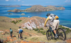
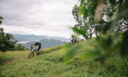
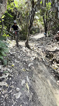
Popular Indonesia Mountain Biking Trails
• 100 ★ 3.0 • 2 miles • 2 ft • 42 •
Unclear if there was every a purpose built trail here, but if there was it has since disappeared into the rain ruts and overgrown jungle. Bring a machete if you intend to complete it top to bottom.
• 100 ★ 0.0 • 4,659 ft • 0 ft • 39 •
Popular black diamond difficulty singletrack. This mountain bike primary trail can be used downhill only and has a moderate overall physical rating. It features berm, drop, jump and gap jump. On average it takes 9 minutes to complete this trail.
• 90 ★ 5.0 • 1,167 ft • 0 ft • 36 •
Popular green difficulty singletrack. This mountain bike primary trail can be used downhill only and has a moderate overall physical rating. It features berm, jump and other. On average it takes 1 minutes to complete this trail.
• 40 ★ 5.0 • 2,374 ft • 7 ft • 35 •
Moderately popular blue difficulty singletrack. This mountain bike primary trail can be used downhill only and has a easy overall physical rating. It features berm, jump and other. On average it takes 6 minutes to complete this trail.
• 100 ★ 0.0 • 1,109 ft • 0 ft • 34 •
Popular blue difficulty singletrack. This mountain bike primary trail can be used downhill only. On average it takes minutes to complete this trail.
• 60 ★ 5.0 • 1,510 ft • 2 ft • 34 •
Moderately popular green difficulty singletrack. This mountain bike primary trail can be used downhill only and has a moderate overall physical rating with a 2 ft green climb. It features berm, jump and other. On average it takes 3 minutes to complete this trail.
• 70 ★ 3.5 • 3,867 ft • 47 ft • 32 •
Popular blue difficulty singletrack. This mountain bike primary trail can be used downhill only. It features berm, drop, jump, gap jump, ladder bridge and other. On average it takes 5 minutes to complete this trail.
• 50 ★ 0.0 • 414 ft • 0 ft • 32 •
Moderately popular blue difficulty singletrack. This mountain bike primary trail can be used downhill only and has a moderate overall physical rating with a 0 ft green climb. It features a-frame, berm, jump and other. On average it takes minutes to complete this trail.
Indonesia Mountain Bike Routes
Panglejar - Cirata Featured
8 miles • 102 ft • 0 • Point to Point •
Starts with a mellow climb and double track descending which then turn into flowy singletracks in the...
56 miles • 8,631 ft • 1 • Loop •
This route I created for the alternate option the other Bromo Loop I created. This one doesn't go down to...
★ 5.0 • 8 miles • 1,977 ft • 0 • Out & Back •
Take an uphill road from beside SD Batulayar. Go all the way to Dusun Penanggak, and turn left to a...
24 miles • 2,370 ft • 3 • Point to Point •
This route is on another side of Puncak Area. Starting from Cipanas, it descend all the way down to...
12 miles • 935 ft • 0 • Point to Point •
The route for Rinjani Enduro Challenge. Lombok, May 2016.
★ 3.0 • 12 miles • 1,092 ft • 0 • Point to Point •
Starting from the western slopes of Mt. Burangrang. Ends at interprovince main road near Purwakarta.
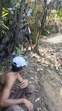
Photos of Indonesia Mountain Bike
Videos of Indonesia Mountain Bike
featured
![First Taste Of A Bali Bike Park Line...]()

797 |
Dec 8, 2015
trail: Rarawea
0:10 |
|
Sep 30, 2024
trail: Rarawea
0:22 |
|
Sep 30, 2024
trail: Rarawea
0:09 |
|
Sep 30, 2024
trail: Rarawea
0:56 |
3 |
Sep 30, 2024
0:13 |
6 |
Sep 11, 2024
trail: Bukit Batu JPG MTB Park
0:40 |
5 |
Mar 20, 2024
trail: Bukit Batu JPG MTB Park
0:29 |
6 |
Mar 8, 2024
Recent Comments
| username | type | title | comment | date |
|---|---|---|---|---|
| report | Correct | Dec 29, 2025 @ 9:15am Dec 29, 2025 | ||
| trail | Very popular trail for both bikers and hikers.... | Dec 1, 2025 @ 8:37am Dec 1, 2025 | ||
| trail | August 2024: abanonded and overgrown but still... | Aug 23, 2024 @ 11:27pm Aug 23, 2024 | ||
| trail | No longer active | Aug 10, 2024 @ 1:35am Aug 10, 2024 | ||
| trail | Start not exist anymore, middle part mostly... | Jan 16, 2024 @ 5:13am Jan 16, 2024 |
Bike & Skill Parks
| name | type | city | rating |
|---|---|---|---|
| Bali Bike Park | bike park | Singaraja | |
| Puncak | bike park | Bogor | |
| Cihideung Gravity Park | bike park | Bogor | |
| Rumah Kebun Bili Bili Bike Park | bike park | Malino | |
| Satharlan Bike Park | skill park | Jakarta |
Activity Type Stats
| activitytype | trails | distance | descent | descent distance | total vertical | rating | global rank | state rank | photos | reports | routes | ridelogs |
|---|---|---|---|---|---|---|---|---|---|---|---|---|
| Mountain Bike | 295 | 623 miles | 205,505 ft | 355 miles | 8,924 ft | #47 | 1,554 | 155 | 38 | 36,704 | ||
| E-Bike | 24 | 38 miles | 14,209 ft | 24 miles | 6,276 ft | #72 | 111 | 9 | 1,210 | |||
| Horse | 2 | 5 miles | 1,716 ft | 2 miles | 3,783 ft | #54 | 52 | |||||
| Hike | 215 | 436 miles | 134,790 ft | 235 miles | 8,917 ft | #55 | 3 | 135 | 1 | 2,671 | ||
| Trail Running | 248 | 442 miles | 136,719 ft | 239 miles | 8,917 ft | #50 | 135 | 5 | 588 | |||
| Dirtbike/Moto | 4 | 7 miles | 1,765 ft | 2 miles | 3,783 ft | #48 | 52 | 4 | ||||
| ATV/ORV/OHV | 1 | 2 miles | 10 ft | 407 ft | 817 ft | #43 | 52 | 1 |
Activities
Trails
Points of Interest
- Ijen Sunrise Northeast Viewpoint
- Upper Waterfall Lookout Viewpoint
- Lower Waterfall Lookout Viewpoint
- Hot Springs Campsite Camping
- Ijen Crate Viewpoint
- Blue Fire Viewpoint
- Ijen Sunrise East Viewpoint
- Hot Pool Other
- Camping Ground Paltuding Gunung Ijen
- Gunung Ijen Summit
- Gunung Sanggar (3,538 m)
- Buntu Nenemori (3,412 m)
- Buntu Rantemario (3,393 m)
- By canadaka
 Trailforks & contributors
 - Admins: jack-jacobs, rifu
- #3184 - 25,948 views
- indonesia activity log | embed map of Indonesia mountain bike trails | indonesia mountain biking points of interest
Downloading of trail gps tracks in kml & gpx formats is enabled for Indonesia.
You must login to download files.