close
-
Layers w
- Weather Layers
- Pro
- Pro
- Pro
- Pro
- Pro
- Pro
- More Layers
- Pro
- Pro
- Pro
- Pro
-
Upgrade to

3D
Trail Conditions
- Unknown
- Snow Groomed
- Snow Packed
- Snow Covered
- Snow Cover Partial
- Freeze/thaw Cycle
- Icy
- Prevalent Mud
- Wet
- Variable
- Ideal
- Dry
- Very Dry
Trail Flow (Ridden Direction)
Trailforks scans users ridelogs to determine the most popular direction each trail is ridden. A good flowing trail network will have most trails flowing in a single direction according to their intension.
The colour categories are based on what percentage of riders are riding a trail in its intended direction.
The colour categories are based on what percentage of riders are riding a trail in its intended direction.
- > 96%
- > 90%
- > 80%
- > 70%
- > 50%
- < 50%
- bi-directional trail
- no data
Trail Last Ridden
Trailforks scans ridelogs to determine the last time a trail was ridden.
- < 2 days
- < 1 week
- < 2 weeks
- < 1 month
- < 6 months
- > 6 months
Trail Ridden Direction
The intended direction a trail should be ridden.
- Downhill Only
- Downhill Primary
- Both Directions
- Uphill Primary
- Uphill Only
- One Direction
Contribute Details
Colors indicate trail is missing specified detail.
- Description
- Photos
- Description & Photos
- Videos
Trail Popularity ?
Trailforks scans ridelogs to determine which trails are ridden the most in the last 9 months.
Trails are compared with nearby trails in the same city region with a possible 25 colour shades.
Think of this as a heatmap, more rides = more kinetic energy = warmer colors.
- most popular
- popular
- less popular
- not popular
ATV/ORV/OHV Filter
Max Vehicle Width
inches
US Cell Coverage
Legend

Radar Time
Activity Recordings
Trailforks uses anonymized public activity data.
?
Activity Recordings
Trailforks uses anonymized public activity data.
?
Personal Heatmap
▶
Activity Types
all
/
none
▶
Options
2
Date range
month
–
Winter Trails
Warning
A routing network for winter maps does not exist. Selecting trails using the winter trails layer has been disabled.
Missing Trails
Most Popular
Least Popular
Trails are colored based on popularity. The more popular a trail is, the more red. Less popular trails trend towards green.
Jump Magnitude Heatmap
Heatmap of where riders jump on trails. Zoom in to see individual jumps, click circles to view jump details.
BC Backroad Status
![map legend]()
Service Road Atlas is a free to use, community-driven service for viewing and creating reports on the numerous back-country service roads around B.C. and Alberta.

Slope Aspect
Direction the slope faces
Trails Deemphasized
Trails are shown in grey.
Only show trails with no bike usage.
Suggested Layers
Based on selected activity type
Save the current map location and zoom level as your default home location whenever this page is loaded.
Save
No description for Jacob Lake has been added yet!
Login or register to submit one.
Activities Click to view
- Mountain Bike
56 trails
- E-Bike
47 trails
- Adaptive Bike
0 trails
- Horse
27 trails
- Hike
69 trails
- Trail Running
69 trails
- Dirtbike/Moto
36 trails
- ATV/ORV/OHV
32 trails
Region Details
- 49
- 2
- 3
- 1
Region Status
Open as of May 30, 2026Local Trail Association
Stats
- Avg Trail Rating
- Trails (view details)
- 68
- Trails Mountain Bike
- 56
- Trails E-Bike
- 47
- Trails Horse
- 27
- Trails Hike
- 69
- Trails Trail Running
- 69
- Trails Dirtbike/Moto
- 36
- Trails ATV/ORV/OHV
- 32
- Total Distance
- 444 miles
- Total Descent Distance
- 223 miles
- Total Descent
- 38,948 ft
- Total Vertical
- 5,604 ft
- Highest Trailhead
- 9,198 ft
- Reports
- 53
- Photos
- 81
- Ridden Counter
- 777
Sub Regions
-
Coyote Buttes
-
Kaibab Plateau
- 3
- 1
Popular Jacob Lake Mountain Biking Trails
• 95 ★ 4.4 • 22 miles • 1,792 ft • 133 •
Singletrack along the north rim of the Grand Canyon. Trail contours a series of drainages through the forest poking out to a few canyon overlooks along the way. Recently the south end has been extended approximately four miles with the...
• 100 ★ 0.0 • 5 miles • 761 ft • 78 •
Extension of Rainbow Rim from junction of forest roads 271 and 271A. First 1.2 miles from FR271 to FR250 is new, well-built singletrack. Remaining 3.8 miles follows old roadbed past Squaw Spring up to near the junction of roads leading...
• 100 ★ 0.0 • 942 ft • 6 ft • 34 •
Popular blue difficulty singletrack. This multi-use trail can be used both directions. On average it takes 9 minutes to complete this trail.
• 70 ★ 4.5 • 2 miles • 10 ft • 22 •
Fun singletrack that can be used to link the Inn to the . The trail does not directly connect to the AZT, but gets close.
• 5 ★ 3.0 • 1 mile • 78 ft • 13 •
Singletrack trail that connects the Inn to the RV Park.
• 5 ★ 3.0 • 12 miles • 1,763 ft • 4 •
Primitive trail once used by sheepherders. Plenty of hike-a-bike, some double track and a few spots of singletrack. GPS is mandatory on this remote, rarely traveled trail.
Jacob Lake Mountain Bike Routes
★ 5.0 • 160 miles • 14,913 ft • 3 • Loop •
Best done as a CCW loop from Jacob Lake over 3 days. The first half of the ride is mostly forest roads,...
21 miles • 1,199 ft • 1 • Point to Point •
Can also be completed as an out-and-back.
144 miles • 12,275 ft • 8 • Loop •
The main loop starts at and follows mostly dirt roads to the north rim of the Grand Canyon. From there the...
144 miles • 12,276 ft • 5 • Loop •
While there are plenty of dirt roads there are also some awesome views of the western Grand Canyon (and a...
16 miles • 332 ft • 1 • Point to Point •
10 miles • 580 ft • 1 • Point to Point •
Photos of Jacob Lake Mountain Bike
Videos of Jacob Lake Mountain Bike
youtuber
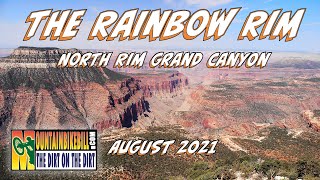
![Grand Canyon MTB at North Rim - Rainbow Rim Trail]()
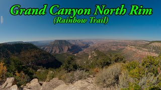
trail: Rainbow Rim
16:37 |
328 |
Feb 26, 2024 , Jacob Lake
trail: Rainbow Rim
9:13 |
716 |
Nov 13, 2021 , Jacob Lake

trail: Navajo Trail
882 |
Nov 16, 2016 , Jacob Lake
Recent Trail Reports
| status | trail | date | condition | info | user |
|---|---|---|---|---|---|
| Rainbow Rim | May 30, 2026 @ 7:06am (America/Phoenix) May 30, 2026 | Unknown | mcsiobhan | ||
| GWT - FR-258 | Apr 28, 2026 @ 11:04am (America/Phoenix) Apr 28, 2026 | Unknown | prummings | ||
| NF-425 | Apr 9, 2025 @ 5:16pm Apr 9, 2025 | Snow Packed | Brandonshep22 Brandon | ||
| Parissawampitts Point | Apr 9, 2025 @ 5:16pm Apr 9, 2025 | Snow Packed | Brandonshep22 Brandon | ||
| AZT/C - East Rim Trailhead Connector | Sep 2, 2024 @ 10:04am Sep 2, 2024 | Ideal | codivist | ||
| AZT/C - Ceballos Trail | Oct 5, 2022 @ 10:52am Oct 5, 2022 | Unknown | jkovaly |
Activity Feed
| username | action | type | title | date |
|---|---|---|---|---|
| SteveOe1r1C | wishlist | route | activity #95990344 | May 31, 2026 @ 5:37pm May 31, 2026 |
| SteveOe1r1C | wishlist | trail | activity #95989830 | May 31, 2026 @ 5:26pm May 31, 2026 |
| mcsiobhan | add | report | activity #95848086 | May 30, 2026 @ 7:06am May 30, 2026 |
| EM-Bike | wishlist | trail | activity #95130157 | May 20, 2026 @ 1:30pm May 20, 2026 |
| bpsweet | wishlist | trail | activity #94846981 | May 16, 2026 @ 1:18pm May 16, 2026 |
Recent Comments
| username | type | title | comment | date |
|---|---|---|---|---|
| trail | Good times | Jul 6, 2024 @ 10:03pm Jul 6, 2024 | ||
| trail | Any current trail beta as of 5/23/23? ❄️ | May 23, 2023 @ 12:48pm May 23, 2023 | ||
| trail | O | Mar 19, 2023 @ 9:37pm Mar 19, 2023 | ||
| trail | The map is correct and yes the road names for... | Jun 10, 2022 @ 4:19pm Jun 10, 2022 | ||
| report | Fence and locust road names on ranger map are... | Jun 8, 2022 @ 9:34pm Jun 8, 2022 |
Local Badges
-

Epic Mountain Bike Climb 2k6 awarded -

Climbing 10k Badge0 awarded -

Mountain Biking 100k Badge0 awarded -

Epic Ride Descent 2k6 awarded -

Descent 10k Badge0 awarded -

Descent 100k Badge0 awarded
Activity Type Stats
| activitytype | trails | distance | descent | descent distance | total vertical | rating | global rank | state rank | photos | reports | routes | ridelogs |
|---|---|---|---|---|---|---|---|---|---|---|---|---|
| Mountain Bike | 56 | 396 miles | 30,692 ft | 200 miles | 4,508 ft | #802 | #311 | 56 | 53 | 16 | 1,582 | |
| E-Bike | 47 | 308 miles | 25,633 ft | 172 miles | 4,508 ft | #306 | #682 | 25 | 41 | 2 | 31 | |
| Horse | 27 | 117 miles | 9,925 ft | 52 miles | 3,219 ft | #528 | #506 | 9 | 3 | |||
| Hike | 69 | 444 miles | 38,947 ft | 223 miles | 5,604 ft | #368 | #175 | 52 | 14 | 554 | ||
| Trail Running | 69 | 444 miles | 38,947 ft | 223 miles | 5,604 ft | #287 | #117 | 52 | 14 | 34 | ||
| Dirtbike/Moto | 36 | 222 miles | 16,509 ft | 112 miles | 4,508 ft | #121 | #74 | 9 | 1 | 4 | ||
| ATV/ORV/OHV | 32 | 188 miles | 13,540 ft | 86 miles | 4,485 ft | #79 | #47 | 9 |
Frequently Asked Questions About Jacob Lake
▼
What are the best places to ride in Jacob Lake?
Jacob Lake has 2 areas to explore for mountain biking. The top rated areas are:
▼
What are the highest rated mountain biking trails in Jacob Lake?
The highest rated mountain biking trails in Jacob Lake are:
- Rainbow Rim (4.2/5)
- AZT/C - Ceballos Trail (4.1/5)
- Jacob Lake Trail (3.8/5)
- Navajo Trail (3.8/5)
- Rainbow Rim Eastern Extension (0/5)
▼
What is the best time of the year to ride in Jacob Lake?
Based on ride log data, the most popular months to ride in Jacob Lake are:
- June (36 activities)
- September (33 activities)
- August (32 activities)
▼
Where can I park to ride in Jacob Lake?
There are 3 parking locations listed in Jacob Lake. The most popular parking spots are: View all parking and trailhead locations on the map to plan your visit.
Activities
Trails
Points of Interest
- Parissawampitts Pt. Viewpoint
- Fence Pt. Viewpoint
- Locust Pt. Viewpoint
- North Timp Pt. Viewpoint
- Timp Pt. Viewpoint
- Jacob Lake Campground Camping
- Sand Hill Petroglyphs Sight
- Scenic View Viewpoint
- Condor Viewing Site Sight
- [Trailhead] Other
- V T Hill (2,705 m)
- South Oak Points (2,400 m)
- North Oak Points (2,386 m)
- By schillingsworth
 TRAILFORKS HTA & contributors
 - Admins: apply
- #5056 - 5,930 views
- jacob lake activity log | embed map of Jacob Lake mountain bike trails | jacob lake mountain biking points of interest
Downloading of trail gps tracks in kml & gpx formats is enabled for Jacob Lake.
You must login to download files.