close
-
Layers w
- Weather Layers
- Pro
- Pro
- Pro
- Pro
- Pro
- Pro
- More Layers
- Pro
- Pro
- Pro
- Pro
-
Upgrade to

3D
Trail Conditions
- Unknown
- Snow Groomed
- Snow Packed
- Snow Covered
- Snow Cover Partial
- Freeze/thaw Cycle
- Icy
- Prevalent Mud
- Wet
- Variable
- Ideal
- Dry
- Very Dry
Trail Flow (Ridden Direction)
Trailforks scans users ridelogs to determine the most popular direction each trail is ridden. A good flowing trail network will have most trails flowing in a single direction according to their intension.
The colour categories are based on what percentage of riders are riding a trail in its intended direction.
The colour categories are based on what percentage of riders are riding a trail in its intended direction.
- > 96%
- > 90%
- > 80%
- > 70%
- > 50%
- < 50%
- bi-directional trail
- no data
Trail Last Ridden
Trailforks scans ridelogs to determine the last time a trail was ridden.
- < 2 days
- < 1 week
- < 2 weeks
- < 1 month
- < 6 months
- > 6 months
Trail Ridden Direction
The intended direction a trail should be ridden.
- Downhill Only
- Downhill Primary
- Both Directions
- Uphill Primary
- Uphill Only
- One Direction
Contribute Details
Colors indicate trail is missing specified detail.
- Description
- Photos
- Description & Photos
- Videos
Trail Popularity ?
Trailforks scans ridelogs to determine which trails are ridden the most in the last 9 months.
Trails are compared with nearby trails in the same city region with a possible 25 colour shades.
Think of this as a heatmap, more rides = more kinetic energy = warmer colors.
- most popular
- popular
- less popular
- not popular
ATV/ORV/OHV Filter
Max Vehicle Width
inches
US Cell Coverage
Legend

Radar Time
Activity Recordings
Trailforks uses anonymized public activity data.
?
Activity Recordings
Trailforks uses anonymized public activity data.
?
Personal Heatmap
▶
Activity Types
all
/
none
▶
Options
2
Date range
month
–
Winter Trails
Warning
A routing network for winter maps does not exist. Selecting trails using the winter trails layer has been disabled.
Missing Trails
Most Popular
Least Popular
Trails are colored based on popularity. The more popular a trail is, the more red. Less popular trails trend towards green.
Jump Magnitude Heatmap
Heatmap of where riders jump on trails. Zoom in to see individual jumps, click circles to view jump details.
BC Backroad Status
![map legend]()
Service Road Atlas is a free to use, community-driven service for viewing and creating reports on the numerous back-country service roads around B.C. and Alberta.

Slope Aspect
Direction the slope faces
Trails Deemphasized
Trails are shown in grey.
Only show trails with no bike usage.
Suggested Layers
Based on selected activity type
Save the current map location and zoom level as your default home location whenever this page is loaded.
SavePopular Trail Networks
view all areas »
No description for Japan has been added yet!
Login or register to submit one.
Region Details
- 87
- 7
- 69
- 139
- 44
- 11
- 6
Stats
- Avg Trail Rating
- Trails (view details)
- 459
- Trails Mountain Bike
- 385
- Trails E-Bike
- 252
- Trails Gravel Bike
- 1
- Trails Horse
- 1
- Trails Hike
- 336
- Trails Trail Running
- 316
- Trails Dirtbike/Moto
- 2
- Trails Observed Trials
- 2
- Trails ATV/ORV/OHV
- 1
- Trails Snowmobile
- 1
- Trails Snowshoe
- 4
- Trails Downhill Ski
- 6
- Trails Backcountry Ski
- 3
- Trails Nordic Ski
- 2
- Total Distance
- 402 miles
- Total Descent
- 127,087 ft
- Total Vertical
- 12,240 ft
- Highest Trailhead
- 12,276 ft
- Reports
- 2,448
- Photos
- 539
- Ridden Counter
- 4,074
Articles

Video: Exploring Japan's Mountain Biking Community & Cultural Roots in ‘Tokowaka'
Dec 2, 2025 from pinkbike.com
A short film exploring how MTB culture is growing alongside long-standing local traditions in rural Japan.
Video: Exploring Japan With the Eastend Crew in 'Overflow'
Nov 12, 2025 from pinkbike.com
The Japanese MTB scene continues to grow.
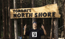
Video: Tomomi Nishikubo Opens “Northshore” Skills Park for All Levels in Japan
Sep 2, 2025 from pinkbike.com
Three new lines—beginner to expert—bring the same creativity from Ride to Survive 2 into a permanent home at Forest Bikepark.
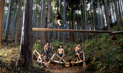
Video: Behind-the-Scenes of Tomomi Nishikubo's Ride to Survive II
Aug 13, 2025 from pinkbike.com
A significant amount of work went into creating one of the best videos of the year so far.
Sub Regions
- Chūbu Region (101)
- Aichi Prefecture (1)
- Gifu Prefecture (9)
- Nagano Prefecture (61)
- Seto (1)
- Yamanashi Prefecture (27)
- Ichikawamisato Town (16)
- Kofu City (3)
- Narusawa (7)
- Ina (2)
- Matsuzaki (0)
- Myoko (2)
- Aichi Prefecture (1)
- Chūgoku Region (18)
- Yamaguchi Prefecture (18)
- Atokaneshimo (3)
- Iwakuni (15)
- Yamaguchi Prefecture (18)
- Hokkaido Region (26)
- Hokkaido Prefecture (23)
- Sapporo (2)
- Kansai Region (16)
- Kantō Region (158)
- Kyushu & Okinawa Region (10)
- Okinawa Prefecture (3)
- Nanjo (3)
- Miyazaki (0)
- Okinawa Prefecture (3)
- Ota (0)
- Shikoku Region (1)
- Tōhoku Region (3)
- Aomori (1)
- Fukushima Prefecture (2)
- Minamiaizu (2)
- Aomori (1)
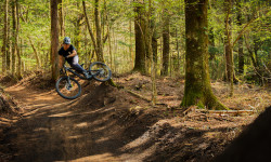
Popular Japan Mountain Biking Trails
• 90 ★ 4.4 • 1,886 ft • 17 ft • 121 •
It's a long trail at a little under 6Kms and 800m decent. Fitness needs to be high. If not, after a couple of days on it, it will be.
• 60 ★ 4.0 • 2,457 ft • 12 ft • 80 •
Moderately popular black diamond difficulty singletrack. This mountain bike primary trail can be used downhill only. On average it takes 11 minutes to complete this trail.
• 100 ★ 0.0 • 1,010 ft • 0 ft • 71 •
Popular black diamond difficulty singletrack. This mountain bike primary trail can be used downhill only. On average it takes 1 minutes to complete this trail.
• 95 ★ 0.0 • 1,115 ft • 4 ft • 69 •
Popular blue difficulty singletrack. This mountain bike primary trail can be used downhill only. On average it takes 1 minutes to complete this trail.
• 85 ★ 0.0 • 3,858 ft • 34 ft • 69 •
Popular green difficulty singletrack. This mountain bike primary trail can be used downhill only.
• 70 ★ 0.0 • 2,116 ft • 23 ft • 68 •
Popular green difficulty singletrack. This mountain bike primary trail can be used downhill only. It features a-frame, berm, bridge, drop, jump, gap jump, ladder bridge, log ride, pump track, rock face, rock garden, roller coaster, skinny and other. On average it takes 2 minutes to complete this trail.
• 90 ★ 0.0 • 994 ft • 0 ft • 67 •
A small alternative to the Alps DH main course through the trees.
• 80 ★ 0.0 • 2 miles • 45 ft • 64 •
Popular green difficulty singletrack. This mountain bike primary trail can be used downhill only.
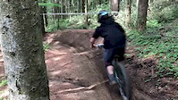
Japan Mountain Bike Routes
Lake Ashi Loop Featured
12 miles • 1,332 ft • 2 •
This is a counter-clockwise loop around the lake that uses a combination of pathway local streets and...
★ 5.0 • 4 miles • 820 ft • 3 • Loop •
It's a fun and easy ride. Park your car at Futatabi Park. Go down Ushi no sen trail. It is a very flowy...
★ 5.0 • 6 miles • 1,652 ft • 0 • Loop •
Minoh is one of the classic riding area in the of Osaka. It has a lot fun drops, some rock garden and...
★ 4.0 • 5 miles • 754 ft • 0 • Loop •
A simple loop starting and ending at Tanigami station. The way down is nice and sweet, rocky, but lots of fun.
6 miles • 1,554 ft • 2 •
This is a map that shows the route through two trails, you go up to the top and then you descend,...
8 miles • 1,634 ft • 2 •
This is a map that shows the route through two trails, you go up to the top and then you descend,...
Photos of Japan Mountain Bike
Videos of Japan Mountain Bike
trail: Takaoyama Trail
0:14 |
22 |
Jan 8, 2024
trail: Kobe Arboretum Trail
8:30 |
45 |
Dec 16, 2020

trail: MBC Line
0:25 |
71 |
May 3, 2020

trail: Roll Coaster to Bashamichi
2:20 |
|
May 10, 2019
trail: Matty's Loops
0:47 |
136 |
May 10, 2019
trail: Bashamichi
2:06 |
159 |
May 10, 2019
trail: Bashamichi
0:47 |
151 |
Jun 14, 2018
trail: Bashamichi
0:25 |
138 |
Jun 14, 2018
Recent Comments
| username | type | title | comment | date |
|---|---|---|---|---|
| trail | Riding along the river is such a nice... | Jun 1, 2025 @ 10:03pm Jun 1, 2025 | ||
| trail | One of the best trails I've ever ridden -... | Jun 1, 2025 @ 9:57pm Jun 1, 2025 | ||
| trail | Mmm | Feb 9, 2025 @ 3:17pm Feb 9, 2025 | ||
| trail | Don't go through the property of the junior... | Jun 25, 2024 @ 10:41am Jun 25, 2024 | ||
| trail | Fun fast trail with roots, berms, drops and jumps | Mar 30, 2024 @ 10:01am Mar 30, 2024 |
Bike & Skill Parks
| name | type | city | rating |
|---|---|---|---|
| Fujimi Panorama Bike Park | bike park | Nagano | |
| Hakuba Iwatake MTB Park | bike park | Hakuba | |
| Fukui Izumi MTB Park | bike park | ||
| Grand Hirafu Bike Park | bike park | Niseko | |
| Yoshimuta | bike park | Nagano |
Activity Type Stats
| activitytype | trails | distance | descent | descent distance | total vertical | rating | global rank | state rank | photos | reports | routes | ridelogs |
|---|---|---|---|---|---|---|---|---|---|---|---|---|
| Mountain Bike | 384 | 287 miles | 103,678 ft | 161 miles | 5,827 ft | #54 | 435 | 2,445 | 20 | 36,460 | ||
| E-Bike | 252 | 168 miles | 57,710 ft | 97 miles | 5,423 ft | #53 | 2,257 | 7 | 1,122 | |||
| Gravel Bike | 1 | #36 | 7 | 44 | 1 | 186 | ||||||
| Horse | 1 | 2 miles | 164 ft | 4,662 ft | 141 ft | #56 | 83 | 6 | ||||
| Hike | 336 | 330 miles | 92,641 ft | 149 miles | 12,241 ft | #44 | 77 | 2,018 | 3 | 6,786 | ||
| Trail Running | 316 | 326 miles | 91,834 ft | 148 miles | 12,241 ft | #51 | 21 | 2,020 | 1 | 416 | ||
| Dirtbike/Moto | 2 | 2 miles | 164 ft | 4,662 ft | 141 ft | #56 | 83 | 10 | ||||
| Observed Trials | 2 | 3 miles | 318 ft | 1 mile | 289 ft | #39 | 2 | |||||
| Snowmobile | 1 | 2 miles | 164 ft | 4,662 ft | 141 ft | #18 | 1 | 34 | ||||
| Snowshoe | 4 | 6 miles | 1,591 ft | 3 miles | 5,974 ft | #15 | 893 | 199 | ||||
| Downhill Ski | 6 | 7 miles | 2,005 ft | 3 miles | 6,086 ft | #16 | 893 | 14,053 | ||||
| Backcountry Ski | 3 | 5 miles | 1,434 ft | 2 miles | 5,827 ft | #14 | 893 | 4,884 | ||||
| Nordic Ski | 2 | 3 miles | 318 ft | 1 mile | 289 ft | #15 | 608 |
Activities
Trails
Points of Interest
- Yamabushi Trail Tour Information
- Twin Peaks trail map Information
- Twin Peaks trail map Information
- Asahigaoka camping ground
- Futagoyama Mtn view Viewpoint
- ニセコ野営場 Camping
- Mt. Annupuri Peak Hut Cabin
- Mt. Yotei Hangetsuko Trailhead Campground Camping
- Yoteizan Hinangoya Cabin
- 剣ヶ峰 (12,310 ft)
- 白山岳 (12,277 ft)
- 朝日岳 (12,221 ft)
- By canadaka
 Trailforks & contributors
 - Admins: KABA, BCpov
- #3241 - 37,499 views
- japan activity log | embed map of Japan mountain bike trails | japan mountain biking points of interest
Downloading of trail gps tracks in kml & gpx formats is enabled for Japan.
You must login to download files.