close
-
Layers w
- Weather Layers
- Pro
- Pro
- Pro
- Pro
- Pro
- Pro
- More Layers
- Pro
- Pro
- Pro
- Pro
-
Upgrade to

3D
Trail Conditions
- Unknown
- Snow Groomed
- Snow Packed
- Snow Covered
- Snow Cover Partial
- Freeze/thaw Cycle
- Icy
- Prevalent Mud
- Wet
- Variable
- Ideal
- Dry
- Very Dry
Trail Flow (Ridden Direction)
Trailforks scans users ridelogs to determine the most popular direction each trail is ridden. A good flowing trail network will have most trails flowing in a single direction according to their intension.
The colour categories are based on what percentage of riders are riding a trail in its intended direction.
The colour categories are based on what percentage of riders are riding a trail in its intended direction.
- > 96%
- > 90%
- > 80%
- > 70%
- > 50%
- < 50%
- bi-directional trail
- no data
Trail Last Ridden
Trailforks scans ridelogs to determine the last time a trail was ridden.
- < 2 days
- < 1 week
- < 2 weeks
- < 1 month
- < 6 months
- > 6 months
Trail Ridden Direction
The intended direction a trail should be ridden.
- Downhill Only
- Downhill Primary
- Both Directions
- Uphill Primary
- Uphill Only
- One Direction
Contribute Details
Colors indicate trail is missing specified detail.
- Description
- Photos
- Description & Photos
- Videos
Trail Popularity ?
Trailforks scans ridelogs to determine which trails are ridden the most in the last 9 months.
Trails are compared with nearby trails in the same city region with a possible 25 colour shades.
Think of this as a heatmap, more rides = more kinetic energy = warmer colors.
- most popular
- popular
- less popular
- not popular
ATV/ORV/OHV Filter
Max Vehicle Width
inches
US Cell Coverage
Legend

Radar Time
Activity Recordings
Trailforks uses anonymized public activity data.
?
Activity Recordings
Trailforks uses anonymized public activity data.
?
Personal Heatmap
▶
Activity Types
all
/
none
▶
Options
2
Date range
month
–
Winter Trails
Warning
A routing network for winter maps does not exist. Selecting trails using the winter trails layer has been disabled.
Missing Trails
Most Popular
Least Popular
Trails are colored based on popularity. The more popular a trail is, the more red. Less popular trails trend towards green.
Jump Magnitude Heatmap
Heatmap of where riders jump on trails. Zoom in to see individual jumps, click circles to view jump details.
BC Backroad Status
![map legend]()
Service Road Atlas is a free to use, community-driven service for viewing and creating reports on the numerous back-country service roads around B.C. and Alberta.

Slope Aspect
Direction the slope faces
Trails Deemphasized
Trails are shown in grey.
Only show trails with no bike usage.
Suggested Layers
Based on selected activity type
Save the current map location and zoom level as your default home location whenever this page is loaded.
SaveMixture of XC, Single Track, AM/DH Jumps Area in South Central Area and Stake Park at Community Centre. Level of Difficulty ranges from Green to Double Black Diamond. Central gravel trail links all major trails. Land Manager,TRCA, does not allow e-bikes on trails and has been actively enforcing e and gas motor bike riders from time to time.
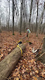
NOTE: Sanctioned trails are marked. Unsanctioned trails are sometimes marked. Recommended to have GPS/Phone for reference as it's very easy to get lost. If you get LOST in the trail system find the Gravel Cut Trail as a easy way back to the trail head. It's the main trail that connects most other trails from top to bottom.
Main Trail Head and Parking is at 999 Bethesda Side Rd
Parking can get crowded on weekends and holidays during the summer. Overflow parking is avilable down the street at the Lake Wilcox and Oak Ridges Community Centre & Pool (12895 Bayview Ave) - Community Centre has a Pay-For Parking Lot with washrooms and vending machines (open during seasonal hours). Ride to East to Trail Head on Bethesda Side Rd. or ride South on Bayview Ave to Dariole Dr (First Traffic Lights) and head East through the residental neighbourhood to access trails.
Recommend Gear:
Eye Protection as some trails get overgrown. Bug Spray for warm seasons and pack accordingly for your ride (hydration, food, spare tube etc.)
Newest Trails:
Rock Logster + Rock n Roll (2025)
Popular Casual Trails:
Gravel Cut
Old Spook
Baby Cake
Flat Out Forward
Field Cruiser
Fruity Loops
Popular XC Trails:
Too Schloppy
Rhythm and Blues
Jefferson Climb
Tracey's Journey
Ocean Motion
Rubber Ducky
The Gauntlet/
Northern Run
Yo Momma
Ridgeliner
Gelato Dreaming
Portage The Full Monty (Winter Only)
Popular AM/Single Track Trails:
Moto XC
Parallel Reality
3 Stubbies
Old Farm Road
Popular AM/DH Trails:
Snake Pit
Chimney Shoot
Dive Bomber
Danny's Downhill
Lunch Line
La Bomba
Primary Trail Type: Cross-Country
eBikes Allowed:
No
Land Status: Conservation Reserve
Land Manager: Toronto Region Conservation Authority
 google parking directions
 Access Info:
Bethesda Trail Head Parking Lot - 999 Bethesda Side Rd (Main parking lot and North end access)
Beware all other parking is restricted in various forms with time and day limits.
Overflow Parking at Lake Wilcox Park and Oak Ridges Community Centre and ride over to trail head - 12895 Bayview Ave - Pay for Parking April 1 - Sept 30 - (check rates online) Free for Richmond Hill Residents with Permit
Central Access at Old Colony Road Parking Lot or Bond Lake Public School (access point to the Oak Ridges Corridor Park ) and ride along the bike path to go under the Bayview Bridge to enter the forest
South Access at Stouffville Rd Trail Entrance. Very limited streetside parking.
OR Park at Gormley GO Station and ride to either Rouge River Access or Stouffville and Bridgewater access point.
Links
Activities Click to view
- Mountain Bike
131 trails
- Hike
127 trails
- Trail Running
123 trails
- Snowshoe
122 trails
- Nordic Ski
32 trails
Region Details
- 14
- 2
- 32
- 33
- 20
- 8
Region Status
Open as of Jun 9, 2026Stats
- Avg Trail Rating
- Trails (view details)
- 109
- Trails Mountain Bike
- 134
- Trails E-Bike
- 1
- Trails Gravel Bike
- 1
- Trails Winter Fat Bike
- 1
- Trails Hike
- 127
- Trails Trail Running
- 123
- Trails Snowshoe
- 122
- Trails Backcountry Ski
- 1
- Trails Nordic Ski
- 32
- Total Distance
- 30 miles
- Total Descent
- 3,133 ft
- Total Vertical
- 167 ft
- Highest Trailhead
- 1,076 ft
- Reports
- 4,717
- Photos
- 235
- Ridden Counter
- 60,215
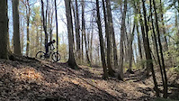
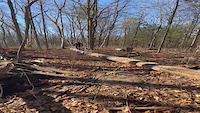
Popular Jefferson Forest Mountain Biking Trails
• 95 ★ 4.1 • 4,426 ft • 39 ft • 1,764 •
Welcome to a rip of a trail that will take you on a tumultuous combination of fast flowy switchbacks followed by some hair of the dog that bit you, uphill switchbacks. Then wander into some low speed super tight squeezes between some...
• 90 ★ 4.3 • 2,562 ft • 98 ft • 1,096 •
This is now a double track multi use trail that connects Central to South entrance route. Suggest that you ride up this, hence the name as there are a lot of walkers and dogs.
• 95 ★ 4.4 • 1,673 ft • 26 ft • 1,089 •
Fun flow trail with a nice descent down and a short uphill climb at the end both ways. Can be used to get to the Northern part of Jefferson Forest, access the Yo-Yo Momma loop or , or the gravel trail with surrounding singletrack...
• 95 ★ 4.4 • 730 ft • 7 ft • 1,081 •
Popular blue difficulty singletrack. This mountain bike primary trail can be used downhill primary and has a moderate overall physical rating with a 7 ft blue climb. On average it takes 1 minutes to complete this trail.
• 100 ★ 4.6 • 3,701 ft • 41 ft • 1,053 •
This is an advanced trail that has several sharp drops, punchy technical climbs, off camber sections and a whole lot of fun. Definitely rideable by advanced riders, intermediate riders can use this trail to advance their riding skills....
• 95 ★ 4.4 • 2,392 ft • 12 ft • 1,024 •
Named after it's close parallel to the Creekbed trail, has quickly become everyone's favourite trail. It's fast, fairly straight, insanely flowy, and is one of the few trails in the forest that was built for the sole purpose of fun!...
Jefferson Forest Mountain Bike Routes
★ 5.0 • 36 miles • 2,466 ft • 126 •
The Jeffy Whole Enchillada is an endurance route to complete every singletrack trail in Jefferson Forest...
★ 5.0 • 9 miles • 654 ft • 25 • Loop •
A moderate loop thru Jefferson Forest that gives an intermediate biker some good flow thru some descending...
★ 3.5 • 12 miles • 1,021 ft • 22 • Loop •
Based on the 2020 Jefferson Jamboree Challenge . This route inlcudes all 7 stages of the challenge in one...
9 miles • 690 ft • 29 • Point to Point •
Section 2 of The Jeffy Whole Enchillada. This section although shorter than Section 1 will prove to be...
★ 2.0 • 9 miles • 482 ft • 27 • Point to Point •
Section 1 of the Jeffy Whole Enchillada. This route includes some of the more popular trails in the forest...
9 miles • 632 ft • 23 • Loop •
Section 4 of The Jeffy Whole Enchillada. The final section starts and returns at the Bethesda Parking Lot....
Photos of Jefferson Forest Mountain Bike
Videos of Jefferson Forest Mountain Bike
trail: Cambria
0:27 |
178 |
Apr 28, 2023
0:46 |
46 |
Dec 11, 2022
trail: Tracey's Journey
0:06 |
188 |
Dec 11, 2022
trail: Get Skinny
0:05 |
45 |
Nov 14, 2022

trail: Disco Don
0:20 |
88 |
Oct 30, 2022
trail: Heavy Metal
0:35 |
|
Oct 13, 2022
trail: BrightSide
0:44 |
256 |
Jul 6, 2022
trail: Jefferson Climb
0:07 |
243 |
May 1, 2022
Recent Trail Reports
| status | trail | date | condition | info | user |
|---|---|---|---|---|---|
| Gelato Dreaming | Jun 9, 2026 @ 5:03pm (America/Toronto) Jun 9, 2026 | Variable | obazante | ||
| Heavy Metal | Jun 9, 2026 @ 5:03pm (America/Toronto) Jun 9, 2026 | Ideal | obazante | ||
| Disco Don | Jun 9, 2026 @ 5:03pm (America/Toronto) Jun 9, 2026 | Ideal | obazante | ||
| Rubber Ducky | Jun 9, 2026 @ 5:03pm (America/Toronto) Jun 9, 2026 | Ideal | obazante | ||
| Flat Out Forward | Jun 9, 2026 @ 5:03pm (America/Toronto) Jun 9, 2026 | Ideal | obazante | ||
| Creek Bed | Jun 9, 2026 @ 5:03pm (America/Toronto) Jun 9, 2026 | Ideal | obazante | ||
| Low Orbit | Jun 9, 2026 @ 5:03pm (America/Toronto) Jun 9, 2026 | Ideal | obazante | ||
| Danny's Downhill | Jun 9, 2026 @ 5:03pm (America/Toronto) Jun 9, 2026 | Ideal | obazante | ||
| Upper Ridge Access | Jun 9, 2026 @ 5:03pm (America/Toronto) Jun 9, 2026 | Ideal | obazante | ||
| South Farm Road | Jun 9, 2026 @ 5:03pm (America/Toronto) Jun 9, 2026 | Ideal | obazante |
Activity Feed
| username | action | type | title | date |
|---|---|---|---|---|
| w2oI2P | ridden | route | activity #96846301 | Jun 12, 2026 @ 8:31pm Jun 12, 2026 |
| obazante | vote | trail | activity #96683659 and 22 more | Jun 10, 2026 @ 10:48am Jun 10, 2026 |
| obazante | add | report | activity #96650117 and 18 more | Jun 9, 2026 @ 8:03pm Jun 9, 2026 |
| ShadrackMuffMXJ24x | vote | trail | activity #96606021 and 3 more | Jun 9, 2026 @ 7:59am Jun 9, 2026 |
| beleafer1967 | wishlist | route | activity #96538193 and 1 more | Jun 8, 2026 @ 7:28am Jun 8, 2026 |
Recent Comments
| username | type | title | comment | date |
|---|---|---|---|---|
| report | Trail is clear | Apr 30, 2026 @ 8:41am Apr 30, 2026 | ||
| report | Thanks | Feb 3, 2026 @ 10:05am Feb 3, 2026 | ||
| report | Fat tires (4” or bigger) preferably with... | Feb 3, 2026 @ 9:24am Feb 3, 2026 | ||
| report | Hi. Are these trails you posted rideable on... | Feb 3, 2026 @ 8:56am Feb 3, 2026 | ||
| report | Clam it! Send it. Edits not | Dec 25, 2025 @ 1:37pm Dec 25, 2025 |
Nearby Areas
| name | distance | ||||
|---|---|---|---|---|---|
| Lake Wilcox Park | 0.7 km | ||||
| Rocking Horse Ranch | 2 | 1.8 km | |||
| Oak Ridges Corridor | 20 | 6 | 1 | 1.9 km | |
| Briar Nine Park & Reserve | 2.6 km | ||||
| Laurentian Park | 3 | 3 | 3.3 km |
Local Badges
-

The Jeffy Whole Enchillada!5 awarded -

Completionist8 awarded
Bike & Skill Parks
| name | type | city | rating |
|---|---|---|---|
| Jefferson Forest Freeride Area | skill park | Richmond Hill |
Activity Type Stats
| activitytype | trails | distance | descent | descent distance | total vertical | rating | global rank | state rank | photos | reports | routes | ridelogs |
|---|---|---|---|---|---|---|---|---|---|---|---|---|
| Mountain Bike | 131 | 30 miles | 3,133 ft | 12 miles | 167 ft | #78 | #6 | 220 | 4,582 | 10 | 26,560 | |
| E-Bike | 1 | 3,802 | 295 | |||||||||
| Gravel Bike | 1 | #110 | #7 | 53 | 3 | 69 | ||||||
| Winter Fat Bike | 1 | #110 | #7 | 1 | 152 | 4 | 110 | |||||
| Hike | 127 | 29 miles | 2,946 ft | 11 miles | 167 ft | #2,689 | #50 | 7 | 4,561 | 1 | 685 | |
| Trail Running | 123 | 29 miles | 2,871 ft | 11 miles | 161 ft | #2,179 | #14 | 6 | 4,553 | 1 | 375 | |
| Snowshoe | 122 | 29 miles | 2,841 ft | 11 miles | 167 ft | #41 | #6 | 2 | 836 | 122 | ||
| Backcountry Ski | 1 | 133 | ||||||||||
| Nordic Ski | 32 | 8 miles | 581 ft | 3 miles | 82 ft | #252 | #10 | 277 | 24 |
Frequently Asked Questions About Jefferson Forest
▼
What are the highest rated mountain biking trails in Jefferson Forest?
The highest rated mountain biking trails in Jefferson Forest are:
- Coroners (4.5/5)
- Danny's Downhill (4.5/5)
- BrightSide (4.5/5)
- White Satin (4.4/5)
- Rhythm and Blues (4.4/5)
▼
What is the best time of the year to ride in Jefferson Forest?
Based on ride log data, the most popular months to ride in Jefferson Forest are:
- July (713 activities)
- May (674 activities)
- August (646 activities)
▼
Where can I park to ride in Jefferson Forest?
There are 2 parking locations listed in Jefferson Forest. The most popular parking spots are:
▼
What is the longest trail in Jefferson Forest?
The longest trail in Jefferson Forest is Too Schloppy at 2.1 km. View all trails sorted by distance.
Activities
Trails
- By lokil & contributors
- Admins: YMBA, YORK
- #8647 - 100,005 views
- jefferson forest activity log | embed map of Jefferson Forest mountain bike trails | jefferson forest mountain biking points of interest
Downloading of trail gps tracks in kml & gpx formats is enabled for Jefferson Forest.
You must login to download files.