close
-
Layers w
- Weather Layers
- Pro
- Pro
- Pro
- Pro
- Pro
- Pro
- More Layers
- Pro
- Pro
- Pro
- Pro
-
Upgrade to

3D
Trail Conditions
- Unknown
- Snow Groomed
- Snow Packed
- Snow Covered
- Snow Cover Partial
- Freeze/thaw Cycle
- Icy
- Prevalent Mud
- Wet
- Variable
- Ideal
- Dry
- Very Dry
Trail Flow (Ridden Direction)
Trailforks scans users ridelogs to determine the most popular direction each trail is ridden. A good flowing trail network will have most trails flowing in a single direction according to their intension.
The colour categories are based on what percentage of riders are riding a trail in its intended direction.
The colour categories are based on what percentage of riders are riding a trail in its intended direction.
- > 96%
- > 90%
- > 80%
- > 70%
- > 50%
- < 50%
- bi-directional trail
- no data
Trail Last Ridden
Trailforks scans ridelogs to determine the last time a trail was ridden.
- < 2 days
- < 1 week
- < 2 weeks
- < 1 month
- < 6 months
- > 6 months
Trail Ridden Direction
The intended direction a trail should be ridden.
- Downhill Only
- Downhill Primary
- Both Directions
- Uphill Primary
- Uphill Only
- One Direction
Contribute Details
Colors indicate trail is missing specified detail.
- Description
- Photos
- Description & Photos
- Videos
Trail Popularity ?
Trailforks scans ridelogs to determine which trails are ridden the most in the last 9 months.
Trails are compared with nearby trails in the same city region with a possible 25 colour shades.
Think of this as a heatmap, more rides = more kinetic energy = warmer colors.
- most popular
- popular
- less popular
- not popular
ATV/ORV/OHV Filter
Max Vehicle Width
inches
US Cell Coverage
Legend

Radar Time
Activity Recordings
Trailforks uses anonymized public activity data.
?
Activity Recordings
Trailforks uses anonymized public activity data.
?
Personal Heatmap
▶
Activity Types
all
/
none
▶
Options
2
Date range
month
–
Winter Trails
Warning
A routing network for winter maps does not exist. Selecting trails using the winter trails layer has been disabled.
Missing Trails
Most Popular
Least Popular
Trails are colored based on popularity. The more popular a trail is, the more red. Less popular trails trend towards green.
Jump Magnitude Heatmap
Heatmap of where riders jump on trails. Zoom in to see individual jumps, click circles to view jump details.
BC Backroad Status
![map legend]()
Service Road Atlas is a free to use, community-driven service for viewing and creating reports on the numerous back-country service roads around B.C. and Alberta.

Slope Aspect
Direction the slope faces
Trails Deemphasized
Trails are shown in grey.
Only show trails with no bike usage.
Suggested Layers
Based on selected activity type
Save the current map location and zoom level as your default home location whenever this page is loaded.
Save
No description for Jericho Mountain has been added yet!
Login or register to submit one.
Primary Trail Type: Cross-Country
Land Status: State Park
Activities Click to view
- ATV/ORV/OHV
44 trails
- Mountain Bike
46 trails
- E-Bike
5 trails
- Hike
46 trails
- Trail Running
46 trails
- Dirtbike/Moto
36 trails
- Snowmobile
26 trails
- Nordic Ski
23 trails
Region Details
- 8
- 19
- 17
- 2
Region Status
Open as of Jun 18, 2025Stats
- Avg Trail Rating
- Trails (view details)
- 48
- Trails Mountain Bike
- 46
- Trails E-Bike
- 5
- Trails Hike
- 46
- Trails Trail Running
- 46
- Trails Dirtbike/Moto
- 36
- Trails ATV/ORV/OHV
- 44
- Trails Snowmobile
- 26
- Trails Backcountry Ski
- 1
- Trails Nordic Ski
- 23
- Total Distance
- 98 miles
- Total Descent Distance
- 45 miles
- Total Descent
- 10,016 ft
- Total Vertical
- 2,002 ft
- Highest Trailhead
- 3,003 ft
- Reports
- 2
- Ridden Counter
- 790
Popular Jericho Mountain Mountain Biking Trails
• 100 ★ 0.0 • 3,330 ft • 299 ft • 36 • • atv
Popular blue difficulty doubletrack. This atv/orv/ohv primary trail can be used both directions. On average it takes 13 minutes to complete this trail.
• 100 ★ 0.0 • 1 mile • 343 ft • 31 • • atv
Popular blue difficulty doubletrack. This atv/orv/ohv primary trail can be used both directions.
• 95 ★ 0.0 • 4,659 ft • 73 ft • 27 • • atv
Popular blue difficulty doubletrack. This atv/orv/ohv primary trail can be used downhill only. On average it takes 4 minutes to complete this trail.
• 95 ★ 0.0 • 3,822 ft • 0 ft • 26 • • atv
Popular green difficulty doubletrack. This atv/orv/ohv primary trail can be used both directions. On average it takes 3 minutes to complete this trail.
• 90 ★ 0.0 • 2,556 ft • 0 ft • 24 • • atv
Popular green difficulty doubletrack. This atv/orv/ohv primary trail can be used both directions.
• 85 ★ 0.0 • 1 mile • 17 ft • 23 • • atv
Popular green difficulty doubletrack. This atv/orv/ohv primary trail can be used downhill only. On average it takes 7 minutes to complete this trail.
• 85 ★ 0.0 • 4,911 ft • 12 ft • 17 • • atv
Popular green difficulty doubletrack. This atv/orv/ohv primary trail can be used both directions. On average it takes 5 minutes to complete this trail.
• 95 ★ 0.0 • 4,255 ft • 130 ft • 17 • • atv
Popular green difficulty doubletrack. This atv/orv/ohv primary trail can be used both directions.
Videos of Jericho Mountain Mountain Bike
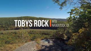
trail: Tobys Trail
7:09 |
100 |
Jul 21, 2024 , Berlin
Recent Trail Reports
| status | trail | date | condition | info | user |
|---|---|---|---|---|---|
| Renes Maze | Aug 11, 2023 @ 5:05pm Aug 11, 2023 | Variable | Lipster94 |
Activity Feed
| username | action | type | title | date |
|---|---|---|---|---|
| skellaher1 | wishlist | trail | activity #84838905 and 9 more | Nov 28, 2025 @ 3:03am Nov 28, 2025 |
| coreyt78 | ridden | trail | activity #76686500 | Jul 25, 2025 @ 1:12pm Jul 25, 2025 |
| SmooshFace | vote | trail | activity #72332511 | May 24, 2025 @ 5:47pm May 24, 2025 |
| Mudcity1970 | ridden | trail | activity #61489871 | Nov 8, 2024 @ 6:03pm Nov 8, 2024 |
| JonathanwGYT1P | add | video | activity #56020728 | Jul 21, 2024 @ 9:20pm Jul 21, 2024 |
Nearby Areas
| name | distance | ||||
|---|---|---|---|---|---|
| Coös Trails | 16 | 21 | 6 | 3 | 6.9 km |
| Rail Trail | 14 km | ||||
| Great Glen Trails | 16 | 7 | 3 | 14.1 km | |
| Trail Pool -White Mountain National Forest | 16 km | ||||
| Highwater | 1 | 16.3 km |
Activity Type Stats
| activitytype | trails | distance | descent | descent distance | total vertical | rating | global rank | state rank | photos | reports | routes | ridelogs |
|---|---|---|---|---|---|---|---|---|---|---|---|---|
| Mountain Bike | 46 | 87 miles | 9,364 ft | 41 miles | 1,998 ft | #7,741 | #2,985 | 2 | 81 | |||
| E-Bike | 5 | 8 miles | 863 ft | 3 miles | 774 ft | #7,923 | #2,400 | 2 | 18 | |||
| Hike | 46 | 87 miles | 9,364 ft | 41 miles | 1,998 ft | #3,098 | #1,070 | 2 | 2 | |||
| Trail Running | 46 | 87 miles | 9,364 ft | 41 miles | 1,998 ft | #2,367 | #573 | 2 | 1 | |||
| Dirtbike/Moto | 36 | 69 miles | 7,648 ft | 32 miles | 2,001 ft | #535 | #156 | 1 | ||||
| ATV/ORV/OHV | 44 | 65 miles | 7,536 ft | 30 miles | 1,673 ft | #303 | #56 | 1 | 4 | |||
| Snowmobile | 26 | 32 miles | 3,619 ft | 15 miles | 1,667 ft | #189 | #57 | 1 | ||||
| Backcountry Ski | 1 | 2 miles | 26 ft | 1,657 ft | 59 ft | |||||||
| Nordic Ski | 23 | 26 miles | 3,478 ft | 14 miles | 1,667 ft | #763 | #289 | 1 |
Frequently Asked Questions About Jericho Mountain
▼
What are the highest rated mountain biking trails in Jericho Mountain?
The highest rated mountain biking trails in Jericho Mountain are:
- Killkenny Conector (4/5)
- Overlook Down (0/5)
- Kimballs Way (0/5)
- Top Loop (0/5)
- Deer Fly (0/5)
▼
Where can I park to ride in Jericho Mountain?
Check the Jericho Mountain trail map for trailhead and parking information. Community members regularly update access and parking details for trails in the area.
▼
What is the longest trail in Jericho Mountain?
The longest trail in Jericho Mountain is Bobo Crow Trail at 3.4 miles. View all trails sorted by distance.
▼
What are the best & highest rated hiking trails in Jericho Mountain?
The best hiking trails in Jericho Mountain are: View all hiking trails sorted by popularity score.
Activities
Trails
Points of Interest
- By backyardsender & contributors
- Admins: apply
- #58652 - 2,820 views
- jericho mountain activity log | embed map of Jericho Mountain mountain bike trails | jericho mountain mountain biking points of interest
Downloading of trail gps tracks in kml & gpx formats is enabled for Jericho Mountain.
You must login to download files.