close
-
Layers w
- Weather Layers
- Pro
- Pro
- Pro
- Pro
- Pro
- Pro
- More Layers
- Pro
- Pro
- Pro
- Pro
-
Upgrade to

3D
Trail Conditions
- Unknown
- Snow Groomed
- Snow Packed
- Snow Covered
- Snow Cover Partial
- Freeze/thaw Cycle
- Icy
- Prevalent Mud
- Wet
- Variable
- Ideal
- Dry
- Very Dry
Trail Flow (Ridden Direction)
Trailforks scans users ridelogs to determine the most popular direction each trail is ridden. A good flowing trail network will have most trails flowing in a single direction according to their intension.
The colour categories are based on what percentage of riders are riding a trail in its intended direction.
The colour categories are based on what percentage of riders are riding a trail in its intended direction.
- > 96%
- > 90%
- > 80%
- > 70%
- > 50%
- < 50%
- bi-directional trail
- no data
Trail Last Ridden
Trailforks scans ridelogs to determine the last time a trail was ridden.
- < 2 days
- < 1 week
- < 2 weeks
- < 1 month
- < 6 months
- > 6 months
Trail Ridden Direction
The intended direction a trail should be ridden.
- Downhill Only
- Downhill Primary
- Both Directions
- Uphill Primary
- Uphill Only
- One Direction
Contribute Details
Colors indicate trail is missing specified detail.
- Description
- Photos
- Description & Photos
- Videos
Trail Popularity ?
Trailforks scans ridelogs to determine which trails are ridden the most in the last 9 months.
Trails are compared with nearby trails in the same city region with a possible 25 colour shades.
Think of this as a heatmap, more rides = more kinetic energy = warmer colors.
- most popular
- popular
- less popular
- not popular
ATV/ORV/OHV Filter
Max Vehicle Width
inches
US Cell Coverage
Legend

Radar Time
Activity Recordings
Trailforks uses anonymized public activity data.
?
Activity Recordings
Trailforks uses anonymized public activity data.
?
Personal Heatmap
▶
Activity Types
all
/
none
▶
Options
2
Date range
month
–
Winter Trails
Warning
A routing network for winter maps does not exist. Selecting trails using the winter trails layer has been disabled.
Missing Trails
Most Popular
Least Popular
Trails are colored based on popularity. The more popular a trail is, the more red. Less popular trails trend towards green.
Jump Magnitude Heatmap
Heatmap of where riders jump on trails. Zoom in to see individual jumps, click circles to view jump details.
BC Backroad Status
![map legend]()
Service Road Atlas is a free to use, community-driven service for viewing and creating reports on the numerous back-country service roads around B.C. and Alberta.

Slope Aspect
Direction the slope faces
Trails Deemphasized
Trails are shown in grey.
Only show trails with no bike usage.
Suggested Layers
Based on selected activity type
Save the current map location and zoom level as your default home location whenever this page is loaded.
SaveThe Dry Creek Trail system offers 26 miles of hiking, biking, and horseback riding awsomeness (sic). The trailhead provides an accessible horse spur and bathroom facilities. Gravel parking for 30 horse trailer rigs.
https://www.fs.usda.gov/recarea/conf/recreation/horseriding-camping/recarea/?recid=10467&actid=104
https://www.fs.usda.gov/recarea/conf/recreation/horseriding-camping/recarea/?recid=10467&actid=104
AKA: Dry Creek Trail System
Land Status: National Forest
Land Manager: Conasauga Ranger District
 google parking directions
Links
Activities Click to view
- Mountain Bike
20 trails
- Horse
13 trails
- Hike
20 trails
- Trail Running
20 trails
Region Details
- 6
- 1
- 10
- 1
Region Status
Open as of Jun 7, 2026Stats
- Avg Trail Rating
- Trails (view details)
- 18
- Trails Mountain Bike
- 20
- Trails Horse
- 13
- Trails Hike
- 20
- Trails Trail Running
- 20
- Total Distance
- 32 miles
- Total Descent
- 2,587 ft
- Total Vertical
- 308 ft
- Highest Trailhead
- 1,054 ft
- Reports
- 255
- Photos
- 10
- Ridden Counter
- 1,499
Popular Dry Creek Trail System Mountain Biking Trails
• 100 ★ 0.0 • 1,453 ft • 57 ft • 98 •
Popular black diamond difficulty singletrack. This multi-use trail. On average it takes 2 minutes to complete this trail.
• 80 ★ 0.0 • 745 ft • 30 ft • 92 •
Popular blue difficulty singletrack. This multi-use trail can be used both directions. On average it takes minutes to complete this trail.
• 75 ★ 2.0 • 3 miles • 196 ft • 88 •
Likely primarily built for horses. Could be a reasonable flow trail if not so overgrown in the summer (literally trees growing up in the middle of the trail).
• 85 ★ 0.0 • 2 miles • 180 ft • 86 •
Popular blue difficulty singletrack. This multi-use trail. On average it takes 48 minutes to complete this trail.
• 30 ★ 0.0 • 6 miles • 451 ft • 79 •
Less popular blue difficulty singletrack. This multi-use trail. On average it takes 52 minutes to complete this trail.
• 40 ★ 0.0 • 1 mile • 136 ft • 47 •
Moderately popular blue difficulty singletrack. This multi-use trail can be used both directions. On average it takes 9 minutes to complete this trail.
• 90 ★ 0.0 • 866 ft • 0 ft • 37 •
Popular blue difficulty singletrack. This multi-use trail. On average it takes 1 minutes to complete this trail.
Dry Creek Trail System Mountain Bike Routes
32 miles • 4,654 ft • 10 • Race •
This is the Snake 34 Mile Route. It starts at the Parking Lot and finishes at the Dalton Trade Center...
• 8 miles • 819 ft • 1 •
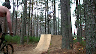
Videos of Dry Creek Trail System Mountain Bike

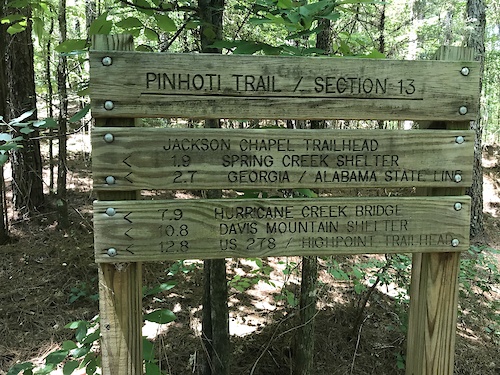
trail: Pinhoti Trail
5:50 |
320 |
Jan 10, 2023
trail: Turkey
2:53 |
385 |
Dec 1, 2011
youtuber
![A most unexpected adventure.]()

19:51 |
364 |
Aug 25, 2020
Recent Trail Reports
| status | trail | date | condition | info | user |
|---|---|---|---|---|---|
| OLD Pinhoti Trail | Mar 14, 2026 @ 9:00am (America/New_York) Mar 14, 2026 | Very Dry | prusek | ||
| Dry Creek Mountain Bike Area Parking | Feb 7, 2026 @ 8:43am (America/Kentucky/Monticello) Feb 7, 2026 | Dry | abi-ridefierce RMBA | ||
| Dry Creek Mountain Bike Area Parking Access | Feb 7, 2026 @ 8:43am (America/Kentucky/Monticello) Feb 7, 2026 | Dry | abi-ridefierce RMBA | ||
| Mount Joy | Nov 22, 2025 @ 2:09pm (America/Kentucky/Monticello) Nov 22, 2025 | Ideal | nweekley22 | ||
| East Armuchee | Feb 12, 2022 @ 5:01am Feb 12, 2022 | Dry | prusek | ||
| Loblolly Spur | Jan 8, 2022 @ 5:04am Jan 8, 2022 | Ideal | prusek | ||
| Dry Creek Road | Apr 3, 2021 @ 3:07pm Apr 3, 2021 | Variable | Rideguyrandy | ||
| Wheat | Apr 25, 2020 @ 1:04pm Apr 25, 2020 | Dry | Steveh83 | ||
| Turkey | Apr 25, 2020 @ 11:58am Apr 25, 2020 | Dry | Steveh83 |
National Scenic Trails & Official Routes
-
Pinhoti Trail (Georgia)
- Mountain Bike
- Hike
- Trail Running
Activity Feed
| username | action | type | title | date |
|---|---|---|---|---|
| floridamanracing | wishlist | region | activity #94194277 | May 6, 2026 @ 7:33pm May 6, 2026 |
| prusek | add | report | activity #90649903 | Mar 15, 2026 @ 12:05pm Mar 15, 2026 |
| abi-ridefierce | add | report | activity #90578164 | Mar 14, 2026 @ 1:15pm Mar 14, 2026 |
| GoldSmoke | ridden | trail | activity #89014858 and 3 more | Feb 16, 2026 @ 6:43am Feb 16, 2026 |
| abi-ridefierce | add | report | activity #88620962 and 1 more | Feb 9, 2026 @ 5:03am Feb 9, 2026 |
Recent Comments
| username | type | title | comment | date |
|---|---|---|---|---|
| trail | Likely primarily built for horses. Could be a... | Jul 9, 2020 @ 1:19am Jul 9, 2020 | ||
| report | Rick Moon cleared this. | May 1, 2020 @ 4:52pm May 1, 2020 | ||
| report | This has been cleared | May 1, 2020 @ 4:51pm May 1, 2020 |
Nearby Areas
| name | distance | ||||
|---|---|---|---|---|---|
| Jarrod's Place | 9 | 5 | 9 | 6 | 5.1 km |
| Pinhoti Trail (NWGA SORBA) | 4 | 7 | 6.8 km | ||
| Calhoun Mountain Bike Park | 1 | 2 | 10.5 km | ||
| Houston Valley OHV Trails | 6 | 15 | 13.8 km | ||
| Crockford-Pigeon Mountain | 15.4 km |
Local Badges
-

Completionist0 awarded
Activity Type Stats
| activitytype | trails | distance | descent | descent distance | total vertical | rating | global rank | state rank | photos | reports | routes | ridelogs |
|---|---|---|---|---|---|---|---|---|---|---|---|---|
| Mountain Bike | 20 | 32 miles | 2,589 ft | 14 miles | 308 ft | #9,196 | #3,603 | 11 | 254 | 1 | 1,363 | |
| Horse | 13 | 25 miles | 2,133 ft | 11 miles | 308 ft | #1,304 | #663 | 7 | 15 | |||
| Hike | 20 | 32 miles | 2,589 ft | 14 miles | 308 ft | #7,277 | #2,662 | 252 | 25 | |||
| Trail Running | 20 | 32 miles | 2,589 ft | 14 miles | 308 ft | #6,409 | #2,039 | 251 | 11 |
Frequently Asked Questions About Dry Creek Trail System
▼
What are the highest rated mountain biking trails in Dry Creek Trail System?
The highest rated mountain biking trails in Dry Creek Trail System are:
- Dry Creek (3.9/5)
- Mount Joy (3.7/5)
- Loblolly Spur (0/5)
- Turkey (0/5)
- Wheat (0/5)
▼
What is the best time of the year to ride in Dry Creek Trail System?
Based on ride log data, the most popular months to ride in Dry Creek Trail System are:
- February (12 activities)
- November (8 activities)
- October (5 activities)
▼
Where can I park to ride in Dry Creek Trail System?
There are 2 parking locations listed in Dry Creek Trail System. The most popular parking spots are:
▼
What is the longest trail in Dry Creek Trail System?
The longest trail in Dry Creek Trail System is East Armuchee at 5.6 miles. View all trails sorted by distance.
Activities
Trails
- Hard trails in Dry Creek Trail System
- Easy trails in Dry Creek Trail System
- Favorite trails in Dry Creek Trail System
- Most ridden trails in Dry Creek Trail System
- Singletrack in Dry Creek Trail System
- Viewpoint trails in Dry Creek Trail System
- Trails with technical features in Dry Creek Trail System
- By brenthillier
 NSMBA TRAILFORKS & contributors
 - Admins: NWGA SORBA
- #3471 - 7,838 views
- dry creek trail system activity log | embed map of Dry Creek Trail System mountain bike trails | dry creek trail system mountain biking points of interest
Downloading of trail gps tracks in kml & gpx formats is enabled for Dry Creek Trail System.
You must login to download files.