close
-
Layers w
- Weather Layers
- Pro
- Pro
- Pro
- Pro
- Pro
- Pro
- More Layers
- Pro
- Pro
- Pro
- Pro
-
Upgrade to

3D
Trail Conditions
- Unknown
- Snow Groomed
- Snow Packed
- Snow Covered
- Snow Cover Partial
- Freeze/thaw Cycle
- Icy
- Prevalent Mud
- Wet
- Variable
- Ideal
- Dry
- Very Dry
Trail Flow (Ridden Direction)
Trailforks scans users ridelogs to determine the most popular direction each trail is ridden. A good flowing trail network will have most trails flowing in a single direction according to their intension.
The colour categories are based on what percentage of riders are riding a trail in its intended direction.
The colour categories are based on what percentage of riders are riding a trail in its intended direction.
- > 96%
- > 90%
- > 80%
- > 70%
- > 50%
- < 50%
- bi-directional trail
- no data
Trail Last Ridden
Trailforks scans ridelogs to determine the last time a trail was ridden.
- < 2 days
- < 1 week
- < 2 weeks
- < 1 month
- < 6 months
- > 6 months
Trail Ridden Direction
The intended direction a trail should be ridden.
- Downhill Only
- Downhill Primary
- Both Directions
- Uphill Primary
- Uphill Only
- One Direction
Contribute Details
Colors indicate trail is missing specified detail.
- Description
- Photos
- Description & Photos
- Videos
Trail Popularity ?
Trailforks scans ridelogs to determine which trails are ridden the most in the last 9 months.
Trails are compared with nearby trails in the same city region with a possible 25 colour shades.
Think of this as a heatmap, more rides = more kinetic energy = warmer colors.
- most popular
- popular
- less popular
- not popular
ATV/ORV/OHV Filter
Max Vehicle Width
inches
US Cell Coverage
Legend

Radar Time
Activity Recordings
Trailforks uses anonymized public activity data.
?
Activity Recordings
Trailforks uses anonymized public activity data.
?
Personal Heatmap
▶
Activity Types
all
/
none
▶
Options
2
Date range
month
–
Winter Trails
Warning
A routing network for winter maps does not exist. Selecting trails using the winter trails layer has been disabled.
Missing Trails
Most Popular
Least Popular
Trails are colored based on popularity. The more popular a trail is, the more red. Less popular trails trend towards green.
Jump Magnitude Heatmap
Heatmap of where riders jump on trails. Zoom in to see individual jumps, click circles to view jump details.
BC Backroad Status
![map legend]()
Service Road Atlas is a free to use, community-driven service for viewing and creating reports on the numerous back-country service roads around B.C. and Alberta.

Slope Aspect
Direction the slope faces
Trails Deemphasized
Trails are shown in grey.
Only show trails with no bike usage.
Suggested Layers
Based on selected activity type
Save the current map location and zoom level as your default home location whenever this page is loaded.
Save
No description for Johnson City has been added yet!
Login or register to submit one.
Activities Click to view
- Mountain Bike
37 trails
- E-Bike
15 trails
- Adaptive Bike
0 trails
- Winter Fat Bike
0 trails
- Hike
63 trails
- Trail Running
63 trails
Region Details
- 2
- 15
- 12
- 7
Region Status
Open as of May 24, 2026Stats
- Avg Trail Rating
- Trails (view details)
- 58
- Trails Mountain Bike
- 37
- Trails E-Bike
- 15
- Trails Gravel Bike
- 1
- Trails Hike
- 63
- Trails Trail Running
- 63
- Total Distance
- 55 miles
- Total Descent
- 9,832 ft
- Total Vertical
- 4,766 ft
- Highest Trailhead
- 6,206 ft
- Reports
- 378
- Photos
- 87
- Ridden Counter
- 5,926
Sub Regions
-
East Tennessee University (ETSU)
- 2
- 2
- 3
-
Tannery Knobs Bike Park
- 5
- 5
- 2
-
Winged Deer Park
- 2
- 5
- 2
Popular Johnson City Mountain Biking Trails
• 90 ★ 4.2 • 3,295 ft • 142 ft • 380 •
is the perfect trail for new riders that want to get a taste for how much fun mountain biking can be. It's a great natural progression for people riding the Tweetsie Trail and might be looking for something a little more challenging....
• 65 ★ 4.8 • 4,213 ft • 146 ft • 360 •
is the region's first purpose-built flow gravity trail and has been optimized for one-way directional riding. The trail does have a couple of sections that require some pedaling, but overall it rewards riders that can keep their...
• 65 ★ 4.4 • 3,514 ft • 35 ft • 351 •
is a two-way traffic and shared use trail with hikers that traverses the south and east sides of Tannery Knobs. The trail is characterized by fun rocky sections and tight, un-bermed turns. This trail can also be used to create an...
• 95 ★ 4.7 • 1,048 ft • 51 ft • 347 •
gives riders a taste for what you typically see on an intermediate level (blue) rated flow trail at other pay-to-play bike parks in the region. Located at 'Hub C', this trail is a great place to hone your skills on low-risk tabletops...
• 70 ★ 4.5 • 2,140 ft • 228 ft • 330 •
serves as the main climbing trail that you'll find yourself using as a number of trails feed into this one. You may be somewhat disappointed to find out that there is no actual to shuttle you to the top. While the trail is not an easy...
• 60 ★ 4.7 • 1,206 ft • 67 ft • 326 •
is one of two black diamond rated trails at Tannery Knobs. The trail has a little bit of everything and takes a few rides to really figure out all the various lines you can take. The trail is characterized by rocky and rooty loose...
• 40 ★ 4.2 • 1,846 ft • 69 ft • 302 •
Do you like rocks served with a side of rockgnar that starts off with a tasty rockatizer? If so, this is the trail for you! Posse's Club is named for a now-closed establishment formerly located around the corner from the park and is one...
• 100 ★ 3.0 • 666 ft • 3 ft • 278 •
The Tannery Knobs Pumptrack built by Velosolutions. Compare your times with your friends and other local riders on this Trailforks Leaderboard
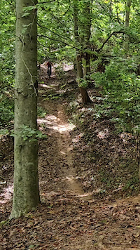
Photos of Johnson City Mountain Bike
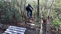
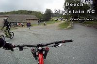
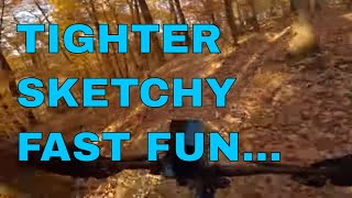
Videos of Johnson City Mountain Bike
trail: YYZ
0:09 |
12 |
Sep 29, 2025
trail: Pump Track
0:55 |
87 |
Mar 6, 2020
trail: Chairlift
6:07 |
522 |
Aug 25, 2012

trail: Breakfast Club
27:38 |
386 |
Nov 23, 2022 , Johnson City
trail: Baby Flow
27:38 |
202 |
Nov 23, 2022 , Johnson City

trail: Posse's Club
27:38 |
162 |
Nov 23, 2022 , Johnson City

trail: Mountain Express
27:38 |
174 |
Nov 23, 2022 , Johnson City

14:49 |
374 |
Aug 17, 2021
Recent Trail Reports
| status | trail | date | condition | info | user |
|---|---|---|---|---|---|
| 4X | May 17, 2026 @ 1:01pm (America/Kentucky/Monticello) May 17, 2026 | Ideal | carraig042 | ||
| Water Tower Bypass | May 17, 2026 @ 1:01pm (America/Kentucky/Monticello) May 17, 2026 | Ideal | carraig042 | ||
| Water Tower Trail | May 17, 2026 @ 1:01pm (America/Kentucky/Monticello) May 17, 2026 | Ideal | carraig042 | ||
| The Heights Downhill | May 17, 2026 @ 1:01pm (America/Kentucky/Monticello) May 17, 2026 | Ideal | carraig042 | ||
| Watertown Access Road | May 17, 2026 @ 1:01pm (America/Kentucky/Monticello) May 17, 2026 | Ideal | carraig042 | ||
| Panorama | May 9, 2026 @ 2:42pm (America/Kentucky/Monticello) May 9, 2026 | Ideal | carraig042 | ||
| Vol Holler | May 9, 2026 @ 2:42pm (America/Kentucky/Monticello) May 9, 2026 | Ideal | carraig042 | ||
| Chairlift | May 9, 2026 @ 2:42pm (America/Kentucky/Monticello) May 9, 2026 | Ideal | carraig042 | ||
| Mountain Express | May 9, 2026 @ 2:42pm (America/Kentucky/Monticello) May 9, 2026 | Ideal | carraig042 | ||
| Cumberland Braaps | May 9, 2026 @ 2:42pm (America/Kentucky/Monticello) May 9, 2026 | Ideal | carraig042 |
Activity Feed
| username | action | type | title | date |
|---|---|---|---|---|
| mcclishfamily | wishlist | region | activity #97688008 | Jun 24, 2026 @ 4:46am 1 day |
| dmartian | ridden | trail | activity #96600610 | Jun 9, 2026 @ 6:11am Jun 9, 2026 |
| carraig042 | add | report | activity #94924785 and 4 more | May 17, 2026 @ 11:29am May 17, 2026 |
| LynchburgNole | add | photo | activity #94455872 | May 10, 2026 @ 1:34pm May 10, 2026 |
| carraig042 | add | report | activity #94374402 and 7 more | May 9, 2026 @ 1:31pm May 9, 2026 |
Recent Comments
| username | type | title | comment | date |
|---|---|---|---|---|
| trail | Trail is clear! | Jan 26, 2024 @ 2:03pm Jan 26, 2024 | ||
| trail | This trail is overgrown. I would not ride it... | Aug 16, 2023 @ 12:08pm Aug 16, 2023 | ||
| trail | Trail damage with logs and larger sticks... | Jul 18, 2022 @ 1:13pm Jul 18, 2022 | ||
| trail | Very awesome flow, just like the rest of the... | Aug 12, 2021 @ 4:18pm Aug 12, 2021 | ||
| trail | Trails are running great! Perfect dirt... | Mar 26, 2020 @ 5:06pm Mar 26, 2020 |
Local Badges
-

Epic Ride Climb 2k26 awarded -

Climbing 10k Badge39 awarded -

Climbing 100k Badge3 awarded -

Epic Ride Descent 2k23 awarded -

Descent 10k Badge39 awarded -

Descent 100k Badge3 awarded
Bike & Skill Parks
| name | type | city | rating |
|---|---|---|---|
| Tannery Knob Skills Park | skill park | Johnson City |
Activity Type Stats
| activitytype | trails | distance | descent | descent distance | total vertical | rating | global rank | state rank | photos | reports | routes | ridelogs |
|---|---|---|---|---|---|---|---|---|---|---|---|---|
| Mountain Bike | 37 | 24 miles | 3,110 ft | 9 miles | 1,414 ft | #2,690 | #960 | 71 | 378 | 8,911 | ||
| E-Bike | 15 | 4 miles | 528 ft | 2 miles | 472 ft | #6,565 | #1,986 | 330 | 213 | |||
| Gravel Bike | 1 | #1,197 | #654 | 1 | 21 | |||||||
| Hike | 63 | 53 miles | 9,209 ft | 22 miles | 4,767 ft | 16 | 368 | 422 | ||||
| Trail Running | 63 | 53 miles | 9,209 ft | 22 miles | 4,767 ft | #3,446 | #1,021 | 368 | 280 |
Frequently Asked Questions About Johnson City
▼
What are the best places to ride in Johnson City?
Johnson City has 5 areas to explore for mountain biking. The top rated areas are:
▼
What are the highest rated mountain biking trails in Johnson City?
The highest rated mountain biking trails in Johnson City are:
- Baby Flow (4.3/5)
- Cumberland Braaps (4.3/5)
- Mountain Express (4.3/5)
- Roll the Bones (4.3/5)
- Chairlift (4.2/5)
▼
What is the best time of the year to ride in Johnson City?
Based on ride log data, the most popular months to ride in Johnson City are:
- July (105 activities)
- October (64 activities)
- April (59 activities)
▼
Where can I park to ride in Johnson City?
There are 14 parking locations listed in Johnson City. The most popular parking spots are: View all parking and trailhead locations on the map to plan your visit.
Activities
Trails
Points of Interest
- Iron Mtn Vista 5 Viewpoint
- Round Knob Summit
- White Rock Summit
- Hucleberry Knob Summit
- Sunset Point Summit
- Buffalo Mountain Summit
- Iron Mtn Vista 1 Viewpoint
- A.T. Shelters: Iron Mtn Shelter Cabin
- Iron Mtn Vista 2 Viewpoint
- Iron Mtn Vista 3 Viewpoint
- Piney Mountain (3,911 ft)
- Pinnacle Mountain (3,540 ft)
- Heupscup Knobs (3,474 ft)
- By brenthillier
 NSMBA TRAILFORKS & contributors
 - Admins: apply
- #10789 - 10,609 views
- johnson city activity log | embed map of Johnson City mountain bike trails | johnson city mountain biking points of interest
Downloading of trail gps tracks in kml & gpx formats is enabled for Johnson City.
You must login to download files.