close
-
Layers w
- Weather Layers
- Pro
- Pro
- Pro
- Pro
- Pro
- Pro
- More Layers
- Pro
- Pro
- Pro
- Pro
-
Upgrade to

3D
Trail Conditions
- Unknown
- Snow Groomed
- Snow Packed
- Snow Covered
- Snow Cover Partial
- Freeze/thaw Cycle
- Icy
- Prevalent Mud
- Wet
- Variable
- Ideal
- Dry
- Very Dry
Trail Flow (Ridden Direction)
Trailforks scans users ridelogs to determine the most popular direction each trail is ridden. A good flowing trail network will have most trails flowing in a single direction according to their intension.
The colour categories are based on what percentage of riders are riding a trail in its intended direction.
The colour categories are based on what percentage of riders are riding a trail in its intended direction.
- > 96%
- > 90%
- > 80%
- > 70%
- > 50%
- < 50%
- bi-directional trail
- no data
Trail Last Ridden
Trailforks scans ridelogs to determine the last time a trail was ridden.
- < 2 days
- < 1 week
- < 2 weeks
- < 1 month
- < 6 months
- > 6 months
Trail Ridden Direction
The intended direction a trail should be ridden.
- Downhill Only
- Downhill Primary
- Both Directions
- Uphill Primary
- Uphill Only
- One Direction
Contribute Details
Colors indicate trail is missing specified detail.
- Description
- Photos
- Description & Photos
- Videos
Trail Popularity ?
Trailforks scans ridelogs to determine which trails are ridden the most in the last 9 months.
Trails are compared with nearby trails in the same city region with a possible 25 colour shades.
Think of this as a heatmap, more rides = more kinetic energy = warmer colors.
- most popular
- popular
- less popular
- not popular
ATV/ORV/OHV Filter
Max Vehicle Width
inches
US Cell Coverage
Legend

Radar Time
Activity Recordings
Trailforks uses anonymized public activity data.
?
Activity Recordings
Trailforks uses anonymized public activity data.
?
Personal Heatmap
▶
Activity Types
all
/
none
▶
Options
2
Date range
month
–
Winter Trails
Warning
A routing network for winter maps does not exist. Selecting trails using the winter trails layer has been disabled.
Missing Trails
Most Popular
Least Popular
Trails are colored based on popularity. The more popular a trail is, the more red. Less popular trails trend towards green.
Jump Magnitude Heatmap
Heatmap of where riders jump on trails. Zoom in to see individual jumps, click circles to view jump details.
BC Backroad Status
![map legend]()
Service Road Atlas is a free to use, community-driven service for viewing and creating reports on the numerous back-country service roads around B.C. and Alberta.

Slope Aspect
Direction the slope faces
Trails Deemphasized
Trails are shown in grey.
Only show trails with no bike usage.
Suggested Layers
Based on selected activity type
Save the current map location and zoom level as your default home location whenever this page is loaded.
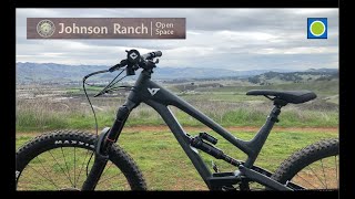
SaveJohnson Ranch Open Space preserves 242 acres of old ranch land just south of San Luis Obispo. The 3.7-mile Johnson Ranch Loop explores the municipal open space, which is dominated by rolling grassy hills accented by serpentine rocks. There is 200 feet of total elevation between the high and low points, a distance that is repeated several times over the meandering loop.
Primary Trail Type: Cross-Country
AKA: Johnson Ranch Open Space
Land Status: Conservation Reserve
 google parking directions
Links
Region Supporters & Maintainers
Activities Click to view
- Mountain Bike
3 trails
- Hike
3 trails
- Trail Running
3 trails
Region Details
- 2
- 1
Region Status
Caution as of Jun 14, 2026Local Trail Association
Stats
- Avg Trail Rating
- Trails (view details)
- 3
- Trails Mountain Bike
- 3
- Trails Hike
- 3
- Trails Trail Running
- 3
- Total Distance
- 4 miles
- Total Descent
- 1,156 ft
- Total Vertical
- 446 ft
- Highest Trailhead
- 528 ft
- Reports
- 209
- Photos
- 22
- Ridden Counter
- 1,609
Popular Johnson Ranch Mountain Biking Trails
• 85 ★ 3.9 • 4,459 ft • 243 ft • 494 •
Trail connecting Irish Hills to Johnson Ranch.
• 70 ★ 3.9 • 2 miles • 316 ft • 449 •
Johnson Ranch Open Space preserves 242 acres of old ranch land just south of San Luis Obispo. The 3.7-mile Johnson Ranch Loop explores the municipal open space, which is dominated by rolling grassy hills accented by serpentine rocks. A...
• 80 ★ 3.9 • 1 mile • 232 ft • 431 •
The Johnson Ranch Loop trail meanders through rolling grassy hills and oak trees. Great as a warmup loop before heading over to Irish Hills via the Johnson Ranch Connector or as a beginner's practice loop. Several easy switchbacks are...
Johnson Ranch Mountain Bike Routes
9 miles • 1,468 ft • 9 •
Giro di SLO 2021 Stage 1: Johnson Oceanview Bandito Mariposa
• 12 miles • 1,836 ft • 4 •
• 4 miles • 734 ft • 2 •
• 3 miles • 366 ft • 1 •
• 6 miles • 936 ft • 3 •
• 5 miles • 922 ft • 1 •
Photos of Johnson Ranch Mountain Bike
Videos of Johnson Ranch Mountain Bike
trail: North Loop
10:52 |
192 |
Jan 17, 2022 , San Luis Obispo

trail: South Loop
10:52 |
217 |
Jan 17, 2022 , San Luis Obispo
Recent Trail Reports
| status | trail | date | condition | info | user |
|---|---|---|---|---|---|
| North Loop | Mar 30, 2026 @ 11:40am (America/Los_Angeles) Mar 30, 2026 | Variable | Ford8N | ||
| South Loop | Mar 30, 2026 @ 11:40am (America/Los_Angeles) Mar 30, 2026 | Variable | Ford8N | ||
| Filipponi Trail | Nov 2, 2024 @ 11:44am Nov 2, 2024 | Ideal | joynt1 |
Activity Feed
| username | action | type | title | date |
|---|---|---|---|---|
| joelgut | wishlist | region | activity #96969873 | Jun 14, 2026 @ 8:07am Jun 14, 2026 |
| RacerGDLvXM | wishlist | region | activity #96602855 | Jun 9, 2026 @ 6:56am Jun 9, 2026 |
| shannig | ridden | trail | activity #95645229 and 1 more | May 27, 2026 @ 10:38am May 27, 2026 |
| Ford8N | add | report | activity #91605065 and 1 more | Mar 30, 2026 @ 1:30pm Mar 30, 2026 |
| Ford8N | add | report | activity #85280254 and 1 more | Dec 9, 2025 @ 12:37pm Dec 9, 2025 |
Recent Comments
| username | type | title | comment | date |
|---|---|---|---|---|
| trail | Lovely flow. | May 29, 2023 @ 7:54pm May 29, 2023 | ||
| trail | Half of this trail is permanently closed. | Apr 23, 2023 @ 3:02pm Apr 23, 2023 | ||
| trail | If you are looking to have a fun time and not... | Nov 24, 2020 @ 5:42pm Nov 24, 2020 | ||
| trail | Due to Covid, the path direction is reversed... | Aug 9, 2020 @ 9:57am Aug 9, 2020 | ||
| trail | Pretty easy. Flows pretty well. Ties in well... | Aug 25, 2019 @ 5:26pm Aug 25, 2019 |
Nearby Areas
| name | distance | ||||
|---|---|---|---|---|---|
| Irish Hills | 1 | 17 | 9 | 1.8 km | |
| South Hills Open Space | 5 | 2.9 km | |||
| South Hills Open Space | 2.9 km | ||||
| Madonna Mountain (Cerro San Luis) | 3 | 17 | 5 | 1 | 3.6 km |
| Ontario Ridge | 2 | 2 | 1 | 3.7 km |
Activity Type Stats
| activitytype | trails | distance | descent | descent distance | total vertical | rating | global rank | state rank | photos | reports | routes | ridelogs |
|---|---|---|---|---|---|---|---|---|---|---|---|---|
| Mountain Bike | 3 | 4 miles | 1,155 ft | 2 miles | 446 ft | #6,728 | #2,570 | 22 | 209 | 1,915 | ||
| Hike | 3 | 4 miles | 1,155 ft | 2 miles | 446 ft | #16,967 | #7,918 | 190 | 140 | |||
| Trail Running | 3 | 4 miles | 1,155 ft | 2 miles | 446 ft | #15,315 | #6,680 | 209 | 211 |
- By aoneal & contributors
- Admins: CCCMB, CCCMB
- #8547 - 5,945 views
- johnson ranch activity log | embed map of Johnson Ranch mountain bike trails | johnson ranch mountain biking points of interest
Downloading of trail gps tracks in kml & gpx formats is enabled for Johnson Ranch.
You must login to download files.