close
-
Layers w
- Weather Layers
- Pro
- Pro
- Pro
- Pro
- Pro
- Pro
- More Layers
- Pro
- Pro
- Pro
- Pro
-
Upgrade to

3D
Trail Conditions
- Unknown
- Snow Groomed
- Snow Packed
- Snow Covered
- Snow Cover Partial
- Freeze/thaw Cycle
- Icy
- Prevalent Mud
- Wet
- Variable
- Ideal
- Dry
- Very Dry
Trail Flow (Ridden Direction)
Trailforks scans users ridelogs to determine the most popular direction each trail is ridden. A good flowing trail network will have most trails flowing in a single direction according to their intension.
The colour categories are based on what percentage of riders are riding a trail in its intended direction.
The colour categories are based on what percentage of riders are riding a trail in its intended direction.
- > 96%
- > 90%
- > 80%
- > 70%
- > 50%
- < 50%
- bi-directional trail
- no data
Trail Last Ridden
Trailforks scans ridelogs to determine the last time a trail was ridden.
- < 2 days
- < 1 week
- < 2 weeks
- < 1 month
- < 6 months
- > 6 months
Trail Ridden Direction
The intended direction a trail should be ridden.
- Downhill Only
- Downhill Primary
- Both Directions
- Uphill Primary
- Uphill Only
- One Direction
Contribute Details
Colors indicate trail is missing specified detail.
- Description
- Photos
- Description & Photos
- Videos
Trail Popularity ?
Trailforks scans ridelogs to determine which trails are ridden the most in the last 9 months.
Trails are compared with nearby trails in the same city region with a possible 25 colour shades.
Think of this as a heatmap, more rides = more kinetic energy = warmer colors.
- most popular
- popular
- less popular
- not popular
ATV/ORV/OHV Filter
Max Vehicle Width
inches
US Cell Coverage
Legend

Radar Time
Activity Recordings
Trailforks uses anonymized public activity data.
?
Activity Recordings
Trailforks uses anonymized public activity data.
?
Personal Heatmap
▶
Activity Types
all
/
none
▶
Options
2
Date range
month
–
Winter Trails
Warning
A routing network for winter maps does not exist. Selecting trails using the winter trails layer has been disabled.
Missing Trails
Most Popular
Least Popular
Trails are colored based on popularity. The more popular a trail is, the more red. Less popular trails trend towards green.
Jump Magnitude Heatmap
Heatmap of where riders jump on trails. Zoom in to see individual jumps, click circles to view jump details.
BC Backroad Status
![map legend]()
Service Road Atlas is a free to use, community-driven service for viewing and creating reports on the numerous back-country service roads around B.C. and Alberta.

Slope Aspect
Direction the slope faces
Trails Deemphasized
Trails are shown in grey.
Only show trails with no bike usage.
Suggested Layers
Based on selected activity type
Save the current map location and zoom level as your default home location whenever this page is loaded.
Save
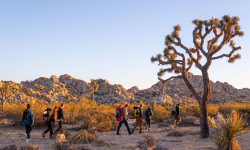
No description for Joshua Tree has been added yet!
Login or register to submit one.
Activities Click to view
- Mountain Bike
40 trails
- E-Bike
12 trails
- Winter Fat Bike
0 trails
- Horse
14 trails
- Hike
130 trails
- Trail Running
130 trails
- Dirtbike/Moto
5 trails
- ATV/ORV/OHV
5 trails
Region Details
- 17
- 10
- 9
- 4
Region Status
Open as of May 15, 2026Stats
- Avg Trail Rating
- Trails (view details)
- 128
- Trails Mountain Bike
- 40
- Trails E-Bike
- 12
- Trails Horse
- 14
- Trails Hike
- 130
- Trails Trail Running
- 130
- Trails Dirtbike/Moto
- 5
- Trails ATV/ORV/OHV
- 5
- Total Distance
- 401 miles
- Total Descent
- 34,402 ft
- Total Vertical
- 5,733 ft
- Highest Trailhead
- 5,794 ft
- Reports
- 235
- Photos
- 205
- Ridden Counter
- 9,966
Articles
The 11 Best Hikes in Joshua Tree National Park
Dec 27, 2024 from outsideonline.com
Experience two of SoCal's stunning desert landscapes—the low Colorado to the east, and the mountainous Mojave to the west—with these gorgeous...
Wanna Hike in California? These Are the 13 Most Stunning Trails.
Jul 18, 2024 from outsideonline.com
A longtime Golden State hiker reveals her dream list of the most beautiful, must-see routes in California
The Best Hikes in Joshua Tree National Park
Sep 22, 2022 from backpacker.com
Full of rock scrambles, cactus clusters, and desert views for days, Joshua Tree National Park is the southwest at its finest.
Sub Regions
-
Desert View Conservation Area
- 9
- 9
- 4
Popular Joshua Tree Mountain Biking Trails
• 85 ★ 4.0 • 1,574 ft • 25 ft • 315 •
Popular green difficulty singletrack. This mountain bike primary trail. On average it takes 4 minutes to complete this trail.
• 95 ★ 4.4 • 3,183 ft • 42 ft • 295 •
Haggis is a single track descent with a nice balance of dirt/sand riding while avoiding rocky obstacles. This trail has the least amount of climbing while descending and flows pretty well.
• 70 ★ 3.7 • 2,048 ft • 71 ft • 254 •
Django is a rocky single track with a fair bit of climbing in the beginning of the trail. Short technical descents, avoiding protruding rocks, are the eventual payoff on this trail.
• 65 ★ 3.3 • 1 mile • 0 ft • 229 •
The Luge is a slightly downhill single track trail that meanders through the lower potion of Section 6. The corners that need support have small berms built in place. Note, there are some sandy sections so plus tires would be best.
• 70 ★ 3.3 • 1,631 ft • 86 ft • 215 •
Popular blue difficulty singletrack. This mountain bike primary trail can be used downhill primary. On average it takes 5 minutes to complete this trail.
• 60 ★ 4.4 • 4,477 ft • 47 ft • 214 •
Moderately popular green difficulty singletrack. This mountain bike primary trail can be used downhill primary. On average it takes 8 minutes to complete this trail.
• 100 ★ 4.5 • 4,367 ft • 63 ft • 199 •
Popular blue difficulty singletrack. This mountain bike primary trail can be used downhill primary. On average it takes 7 minutes to complete this trail.
Joshua Tree Mountain Bike Routes
★ 4.0 • 10 miles • 1,121 ft • 11 •
If you're looking to hit all - or most - of the trails at Joshua Tree, this loop covers them all.
★ 5.0 • 9 miles • 1,035 ft • 11 • Loop •
A route linking up all of the Black rated trails in the Joshua Tree area, with most of the Blues and a few...
★ 3.0 • 7 miles • 934 ft • 10 • Loop •
A route linking up all of the Black rated trails in the Joshua Tree area, with most of the Blues and a few...
47 miles • 5,046 ft • 0 • Out & Back •
This is the entire 50 mile route for the Bike For Bender Pioneertown Ride. There are aid stations located...
★ 1.0 • 25 miles • 2,184 ft • 1 •
Section 6 of a series of connecting mountain bike trails extending from Southern California to Canada....
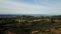
Photos of Joshua Tree Mountain Bike
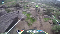
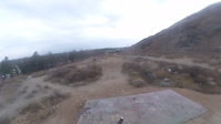
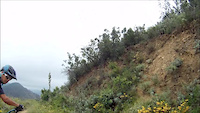
Videos of Joshua Tree Mountain Bike
trail: Django
0:22 |
|
Jan 27, 2021
trail: The Luge
2:17 |
187 |
Mar 6, 2017
trail: Southridge
0:38 |
309 |
Jan 20, 2017

trail: Southridge
5:09 |
82 |
Dec 17, 2016
trail: Southridge
0:40 |
52 |
Nov 3, 2016
trail: The Luge
7:07 |
127 |
May 25, 2016

trail: Southridge
5:23 |
79 |
Apr 22, 2016

trail: Southridge
6:36 |
93 |
Mar 26, 2016
Recent Trail Reports
Activity Feed
| username | action | type | title | date |
|---|---|---|---|---|
| ericlaustin | ridden | trail | activity #94696758 and 3 more | May 14, 2026 @ 9:49am May 14, 2026 |
| Neyloj2 | wishlist | trail | activity #93083006 | Apr 21, 2026 @ 8:38am Apr 21, 2026 |
| Neyloj2 | wishlist | route | activity #92914479 | Apr 18, 2026 @ 7:18pm Apr 18, 2026 |
| BansheeHRF | add | report | activity #92166196 and 1 more | Apr 7, 2026 @ 11:21pm Apr 7, 2026 |
| BrookeQYHO9s | wishlist | route | activity #92147997 | Apr 7, 2026 @ 4:13pm Apr 7, 2026 |
Recent Comments
| username | type | title | comment | date |
|---|---|---|---|---|
| trail | Absolutely incredible trail. Sub-10 min climb... | Mar 31, 2026 @ 4:12pm Mar 31, 2026 | ||
| trail | Pretty average blue trail. | Nov 28, 2025 @ 1:51pm Nov 28, 2025 | ||
| trail | Very much a blue trail. Twisty and choppy but... | Nov 28, 2025 @ 1:50pm Nov 28, 2025 | ||
| trail | The only true black trail in this area. Steep... | Nov 28, 2025 @ 1:47pm Nov 28, 2025 | ||
| trail | Excellent blue trail with good flow and... | Nov 28, 2025 @ 1:43pm Nov 28, 2025 |
Local Badges
-

Epic Ride Climb 2k8 awarded -

Climbing 10k Badge9 awarded -

Climbing 100k Badge0 awarded -

Epic Ride Descent 2k13 awarded -

Descent 10k Badge9 awarded -

Descent 100k Badge0 awarded
Activity Type Stats
| activitytype | trails | distance | descent | descent distance | total vertical | rating | global rank | state rank | photos | reports | routes | ridelogs |
|---|---|---|---|---|---|---|---|---|---|---|---|---|
| Mountain Bike | 40 | 212 miles | 14,373 ft | 102 miles | 4,439 ft | #1,282 | #490 | 157 | 231 | 5 | 3,874 | |
| E-Bike | 12 | 170 miles | 9,888 ft | 83 miles | 3,278 ft | #1,096 | #813 | 181 | 1 | 257 | ||
| Horse | 14 | 66 miles | 7,352 ft | 34 miles | 4,839 ft | #926 | #635 | 4 | 1 | |||
| Hike | 130 | 401 miles | 34,403 ft | 176 miles | 5,732 ft | #241 | #125 | 45 | 236 | 1 | 6,527 | |
| Trail Running | 130 | 401 miles | 34,403 ft | 176 miles | 5,732 ft | #305 | #121 | 236 | 1 | 616 | ||
| Dirtbike/Moto | 5 | 45 miles | 3,297 ft | 21 miles | 1,440 ft | #710 | #252 | 4 | 17 | |||
| ATV/ORV/OHV | 5 | 45 miles | 3,297 ft | 21 miles | 1,440 ft | #507 | #176 | 4 | 4 | 5 |
Frequently Asked Questions About Joshua Tree
▼
What are the best places to ride in Joshua Tree?
Joshua Tree has 2 areas to explore for mountain biking. The top rated areas are:
▼
What are the highest rated mountain biking trails in Joshua Tree?
The highest rated mountain biking trails in Joshua Tree are:
- Long May You Run (4.3/5)
- Haggis (4.2/5)
- Southridge (4.2/5)
- Bad Manor (4.1/5)
- Eastside Vista (4.1/5)
▼
What is the best time of the year to ride in Joshua Tree?
Based on ride log data, the most popular months to ride in Joshua Tree are:
- March (40 activities)
- December (31 activities)
- November (31 activities)
▼
Where can I park to ride in Joshua Tree?
There are 27 parking locations listed in Joshua Tree. The most popular parking spots are: View all parking and trailhead locations on the map to plan your visit.
Activities
Trails
Points of Interest
- By chuktA
 TRAILFORKS NFTA & contributors
 - Admins: apply
- #18572 - 15,391 views
- joshua tree activity log | embed map of Joshua Tree mountain bike trails | joshua tree mountain biking points of interest
Downloading of trail gps tracks in kml & gpx formats is enabled for Joshua Tree.
You must login to download files.