close
-
Layers w
- Weather Layers
- Pro
- Pro
- Pro
- Pro
- Pro
- Pro
- More Layers
- Pro
- Pro
- Pro
- Pro
-
Upgrade to

3D
Trail Conditions
- Unknown
- Snow Groomed
- Snow Packed
- Snow Covered
- Snow Cover Partial
- Freeze/thaw Cycle
- Icy
- Prevalent Mud
- Wet
- Variable
- Ideal
- Dry
- Very Dry
Trail Flow (Ridden Direction)
Trailforks scans users ridelogs to determine the most popular direction each trail is ridden. A good flowing trail network will have most trails flowing in a single direction according to their intension.
The colour categories are based on what percentage of riders are riding a trail in its intended direction.
The colour categories are based on what percentage of riders are riding a trail in its intended direction.
- > 96%
- > 90%
- > 80%
- > 70%
- > 50%
- < 50%
- bi-directional trail
- no data
Trail Last Ridden
Trailforks scans ridelogs to determine the last time a trail was ridden.
- < 2 days
- < 1 week
- < 2 weeks
- < 1 month
- < 6 months
- > 6 months
Trail Ridden Direction
The intended direction a trail should be ridden.
- Downhill Only
- Downhill Primary
- Both Directions
- Uphill Primary
- Uphill Only
- One Direction
Contribute Details
Colors indicate trail is missing specified detail.
- Description
- Photos
- Description & Photos
- Videos
Trail Popularity ?
Trailforks scans ridelogs to determine which trails are ridden the most in the last 9 months.
Trails are compared with nearby trails in the same city region with a possible 25 colour shades.
Think of this as a heatmap, more rides = more kinetic energy = warmer colors.
- most popular
- popular
- less popular
- not popular
ATV/ORV/OHV Filter
Max Vehicle Width
inches
US Cell Coverage
Legend

Radar Time
Activity Recordings
Trailforks uses anonymized public activity data.
?
Activity Recordings
Trailforks uses anonymized public activity data.
?
Personal Heatmap
▶
Activity Types
all
/
none
▶
Options
2
Date range
month
–
Winter Trails
Warning
A routing network for winter maps does not exist. Selecting trails using the winter trails layer has been disabled.
Missing Trails
Most Popular
Least Popular
Trails are colored based on popularity. The more popular a trail is, the more red. Less popular trails trend towards green.
Jump Magnitude Heatmap
Heatmap of where riders jump on trails. Zoom in to see individual jumps, click circles to view jump details.
BC Backroad Status
![map legend]()
Service Road Atlas is a free to use, community-driven service for viewing and creating reports on the numerous back-country service roads around B.C. and Alberta.

Slope Aspect
Direction the slope faces
Trails Deemphasized
Trails are shown in grey.
Only show trails with no bike usage.
Suggested Layers
Based on selected activity type
Save the current map location and zoom level as your default home location whenever this page is loaded.
SaveNote about trail difficulty: (At least in many places) Their local trail difficulty system isn't according international standard. Their red is black, and black is double black.
Region Details
- 118
- 9
- 75
- 206
- 15
- 8
Stats
- Avg Trail Rating
- Trails (view details)
- 525
- Trails Mountain Bike
- 538
- Trails E-Bike
- 375
- Trails Gravel Bike
- 1
- Trails Adaptive Bike
- 3
- Trails Horse
- 19
- Trails Hike
- 314
- Trails Trail Running
- 330
- Trails Snowshoe
- 1
- Trails Downhill Ski
- 2
- Trails Backcountry Ski
- 12
- Total Distance
- 363 miles
- Total Descent
- 35,084 ft
- Total Vertical
- 509 ft
- Highest Trailhead
- 518 ft
- Reports
- 7,419
- Photos
- 973
- Ridden Counter
- 35,527
Popular Trail Networks
view all areas »Sub Regions
- Aarhus Kommune (58)
- Aarhus (58)
- Marselisborg (56)
- Skølhøjkilen (1)
- Aarhus (58)
- Brande Kommune (3)
- Horsens Kommune (32)
- Horsens (32)
- Bjerge Skov (31)
- Horsens (32)
- Randers Kommune (40)
- Randers (6)
- Romalt Bakker (5)
- Svinding (22)
- Fussingø (22)
- Randers (6)
- Silkeborg Kommune (139)
- Gjern (25)
- Silkeborg (104)
- Gjessø skov, Rustrup Skov, Thorsø og Bødskovgård (2)
- Nordskoven (40)
- Silkeborg Bikepark (12)
- Søhøjlandet (17)
- Vesterskoven (25)
- Østerskov (2)
- Gjern (25)
- Skanderborg Kommune (53)
- Ry (40)
- Danmarks Tag (26)
- Skanderborg (13)
- Ry (40)
- Viborg Kommune (143)
- Bjerringbro (2)
- Bækkelund (2)
- Hald Ege (6)
- Havredal (2)
- Sjørup (1)
- Sjørup Skov (1)
- Stanhede (16)
- MTB Stanhede (16)
- Ulstrup (14)
- Ulstrup Skov (14)
- Viborg (100)
- Neckelmann (29)
- Skrikes Plantage (8)
- Undalslund Trail Center (43)
- Ødalen (6)
- Aarhus V (1)
- Ebeltoft (4)
- Mols Bjerge (2)
- Enderupskov (12)
- Stensbæk Plantage (11)
- Farsø (4)
- Fjerritslev (0)
- Slettestrand (0)
- Grenaa (1)
- Haderslev (24)
- Holstebro (20)
- Stendal Plantage (2)
- Hønsnap (24)
- Kelstrup Plantage (24)
- Kolding (3)
- Rebild (9)
- Rold Skov (5)
- Ringkøbing (1)
- Sinding (1)
- Skive (5)
- Storvorde (1)
- Struer (2)
- Sønderborg (10)
- Vejen (2)
- Ølgod (1)
Popular Region Midtjylland (Central Denmark) Trails
• 100 ★ 3.0 • 1 mile • 77 ft • 303 •
Popular blue difficulty singletrack. This multi-use trail can be used one direction. It features berm and jump. Trail visibility is always easy to follow. On average it takes 5 minutes to complete this trail.
• 100 ★ 2.5 • 2,087 ft • 50 ft • 298 •
Popular blue difficulty singletrack. This multi-use trail can be used one direction and has a easy overall physical rating with a 50 ft green climb. It features berm and jump. Trail visibility is always easy to follow. On average it takes 1 minutes to complete this trail.
• 100 ★ 3.0 • 3,635 ft • 123 ft • 297 •
Popular blue difficulty singletrack. This multi-use trail can be used one direction and has a easy overall physical rating with a 123 ft blue climb. It features berm and bridge. Trail visibility is always easy to follow. On average it takes 5 minutes to complete this trail.
• 95 ★ 4.0 • 4,377 ft • 112 ft • 292 •
Popular blue difficulty singletrack. This multi-use trail can be used one direction and has a easy overall physical rating with a 112 ft green climb. It features berm. Trail visibility is always easy to follow. On average it takes 5 minutes to complete this trail.
• 100 ★ 2.5 • 1,965 ft • 73 ft • 289 •
Popular blue difficulty singletrack. This multi-use trail can be used one direction and has a easy overall physical rating with a 73 ft green climb. It features berm. Trail visibility is always easy to follow. On average it takes 5 minutes to complete this trail.
• 95 ★ 3.0 • 3,681 ft • 49 ft • 288 •
Popular blue difficulty singletrack. This multi-use trail can be used one direction and has a easy overall physical rating with a 49 ft green climb. It features berm. Trail visibility is always easy to follow. On average it takes 3 minutes to complete this trail.
• 95 ★ 2.0 • 2,208 ft • 39 ft • 288 •
Popular blue difficulty singletrack. This multi-use trail can be used one direction and has a easy overall physical rating with a 39 ft green climb. It features berm. Trail visibility is always easy to follow. On average it takes 2 minutes to complete this trail.
• 90 ★ 2.0 • 2,484 ft • 140 ft • 286 •
Popular blue difficulty singletrack. This multi-use trail can be used one direction and has a easy overall physical rating with a 140 ft green climb. It features berm. Trail visibility is always easy to follow. On average it takes 6 minutes to complete this trail.
Mountain Bike Routes
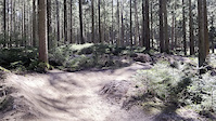
Nordskoven Blå Spor Featured
★ 5.0 • 6 miles • 667 ft • 16 • Loop •
Dette er primært det blå spor. Ud fra dette kan man tage røde og sorte afstikkere
Vesterskoven Blå Spor Featured
★ 5.0 • 11 miles • 1,279 ft • 21 •
Vesterskovens blå spor hele vejen rundt.
Vesterskoven Rød Spor Featured
11 miles • 1,330 ft • 19 • Out & Back •
Rød route I versterskoven, består mest af blå spor
Nordskoven Sort Spor Featured
8 miles • 1,121 ft • 29 • Out & Back •
Nordskoven Sort Spor er en udfordrende rute for dem som gerne vil afprøve deres evner
Nordskoven Rød Spor Featured
7 miles • 855 ft • 26 • Out & Back •
Tur rundt i Nordskoven med de røde linier
Romalt Bakker Featured
4 miles • 601 ft • 0 • Loop •
Trail partly in the forest and on meadows with some short steep climbs and descends. There are some red...
Photos of Region Midtjylland (Central Denmark) Mountain Bike
Videos of Region Midtjylland (Central Denmark) Mountain Bike
trail: Hugorms Hale
0:07 |
6 |
Jun 6, 2026

0:07 |
4 |
Apr 28, 2026
0:10 |
5 |
Oct 19, 2025
0:40 |
6 |
Aug 24, 2025
trail: Madam Blå
0:30 |
17 |
Jun 27, 2025
trail: Motorvejssløjfen Rød
2:55 |
47 |
Aug 29, 2024
trail: Musvågen
0:03 |
30 |
Jun 23, 2022
trail: Musvågen
0:05 |
4 |
Jun 23, 2022
Current Trail Warnings
| status | trail | date | condition | user | info |
|---|---|---|---|---|---|
| Hugormen Nordskoven | Jun 21, 2026 @ 2:18pm (Europe/Copenhagen) Jun 21, 2026 | Unknown | NiccoNordborg GR-TB-NSKOV | Nyt drop på mellemstykket, samt nyt burm... |
Recent Trail Reports
| status | trail | date | condition | info | user |
|---|---|---|---|---|---|
| Gyngen Nordskoven | Jun 23, 2026 @ 10:31am (Europe/Copenhagen) Jun 23, 2026 | Unknown | NiccoNordborg GR-TB-NSKOV | ||
| Ødalen harder trail 5 Ødalen | Jun 18, 2026 @ 7:30pm (Europe/Copenhagen) Jun 18, 2026 | Ideal | ragger40 | ||
| Ødalen harder trail 3 Ødalen | Jun 18, 2026 @ 7:30pm (Europe/Copenhagen) Jun 18, 2026 | Ideal | ragger40 | ||
| Femmøller Enduro Mols Bjerge | Jun 15, 2026 @ 2:52pm (Europe/Copenhagen) Jun 15, 2026 | Ideal | Fabrif1989 | ||
| Rød kæberasler loop Nordskoven | Jun 13, 2026 @ 8:55am (Europe/Copenhagen) Jun 12, 2026 | Ideal | trail-niels | ||
| Kæberasleren Nordskoven | Jun 13, 2026 @ 8:55am (Europe/Copenhagen) Jun 12, 2026 | Ideal | trail-niels | ||
| Sidste knold Nordskoven | Jun 13, 2026 @ 8:55am (Europe/Copenhagen) Jun 12, 2026 | Ideal | trail-niels | ||
| Over Ulvehoved - Sokær Nordskoven | Jun 13, 2026 @ 8:55am (Europe/Copenhagen) Jun 12, 2026 | Ideal | trail-niels | ||
| HQ svinget Nordskoven | Jun 13, 2026 @ 8:55am (Europe/Copenhagen) Jun 12, 2026 | Ideal | trail-niels | ||
| Over Ulvehoved blå Nordskoven | Jun 13, 2026 @ 8:55am (Europe/Copenhagen) Jun 12, 2026 | Ideal | trail-niels |
Activity Feed
| username | action | type | title | date |
|---|---|---|---|---|
| DanielV | wishlist | route | activity #97818293 | Jun 25, 2026 @ 11:46pm 13 hours |
| JohnLccV3C | add | trail | activity #97701039 | Jun 24, 2026 @ 8:49am 2 days |
| BjrnCL5iOw | vote | trail | activity #97617320 | Jun 23, 2026 @ 4:31am Jun 23, 2026 |
| martinhoegh | like | report | activity #97612360 | Jun 23, 2026 @ 1:32am Jun 23, 2026 |
| NiccoNordborg | add | report | activity #97612341 | Jun 23, 2026 @ 1:31am Jun 23, 2026 |
Recent Comments
| username | type | title | comment | date |
|---|---|---|---|---|
| trail | The trail i going the other way round, from... | Jun 10, 2026 @ 5:10am Jun 10, 2026 | ||
| report | Spordag Dato 25/10 | Apr 28, 2026 @ 11:26am Apr 28, 2026 | ||
| report | Træet er fjernet | Oct 11, 2025 @ 6:44am Oct 11, 2025 | ||
| report | Hej Niels. Skal vi mødes uden på det sted... | Oct 10, 2025 @ 11:08am Oct 10, 2025 | ||
| report | Thorbjørn Nørgård Lovende... | Oct 6, 2025 @ 1:28pm Oct 6, 2025 |
Local Badges
-

Mountain Biking 100k Badge0 awarded -

Epic Ride Descent 2k0 awarded -
Epic Ride Descent 2k0 awarded -
Mountain Biking 100k Badge0 awarded -
Mountain Biking 100k Badge0 awarded -
Mountain Biking 100k Badge0 awarded
Bike & Skill Parks
| name | type | city | rating |
|---|---|---|---|
| Silkeborg Bikepark | bike park | Silkeborg | |
| Rold Skov MTB Teknik Område | skill park | Rebild | |
| Ødalen dirt | skill park | Holstebro | |
| Undallslund Trail Center | skill park | Viborg | |
| Hammer bakker teknikbane | skill park | Vodskov |
Upcoming Local Events
Local Trail Supporters
- Silkeborg Sti- og Sporbyggerlaug
- Skanderborg MTB
Local Trail Supporters
- Silkeborg Sti- og Sporbyggerlaug
- Skanderborg MTB
Activity Type Stats
| activitytype | trails | distance | descent | descent distance | total vertical | rating | global rank | state rank | photos | reports | routes | ridelogs |
|---|---|---|---|---|---|---|---|---|---|---|---|---|
| Mountain Bike | 535 | 355 miles | 34,344 ft | 136 miles | 509 ft | 977 | 7,418 | 28 | 68,308 | |||
| E-Bike | 375 | 189 miles | 15,817 ft | 67 miles | 499 ft | 3 | 7,226 | 12 | 6,456 | |||
| Gravel Bike | 1 | 65 | 1 | 1,088 | ||||||||
| Adaptive Bike | 3 | 6 | 3 | |||||||||
| Horse | 19 | 16 miles | 1,270 ft | 7 miles | 302 ft | 786 | ||||||
| Hike | 314 | 189 miles | 15,984 ft | 72 miles | 509 ft | 4 | 7,029 | 2,585 | ||||
| Trail Running | 330 | 195 miles | 16,686 ft | 75 miles | 509 ft | 7,034 | 775 | |||||
| Snowshoe | 1 | 3,940 ft | 161 ft | 2,618 ft | 157 ft | 1 | 1 | |||||
| Downhill Ski | 2 | 4,829 ft | 174 ft | 3,077 ft | 210 ft | 1 | 8 | |||||
| Backcountry Ski | 12 | 12 miles | 1,017 ft | 6 miles | 253 ft | 2 | 12 |
Activities
- Region Midtjylland (Central Denmark) Mountain Biking Trails
- Region Midtjylland (Central Denmark) E-Biking Trails
- Region Midtjylland (Central Denmark) Horseback Trails
- Region Midtjylland (Central Denmark) Hiking Trails
- Region Midtjylland (Central Denmark) Trail Running Trails
- Region Midtjylland (Central Denmark) Backcountry Skiing Trails
Trails
- Hard trails in Region Midtjylland (Central Denmark)
- Easy trails in Region Midtjylland (Central Denmark)
- Favorite trails in Region Midtjylland (Central Denmark)
- Most ridden trails in Region Midtjylland (Central Denmark)
- Singletrack in Region Midtjylland (Central Denmark)
- Viewpoint trails in Region Midtjylland (Central Denmark)
- Trails with technical features in Region Midtjylland (Central Denmark)
- Race routes in Region Midtjylland (Central Denmark)
- By trail-niels
 & contributors
 - Admins: trail-niels
- #24807 - 6,652 views
- region midtjylland (central denmark) activity log | embed map of Region Midtjylland (Central Denmark) mountain bike trails | region midtjylland (central denmark) mountain biking points of interest polygons
Downloading of trail gps tracks in kml & gpx formats is enabled for Region Midtjylland (Central Denmark).
You must login to download files.