close
-
Layers w
- Weather Layers
- Pro
- Pro
- Pro
- Pro
- Pro
- Pro
- More Layers
- Pro
- Pro
- Pro
- Pro
-
Upgrade to

3D
Trail Conditions
- Unknown
- Snow Groomed
- Snow Packed
- Snow Covered
- Snow Cover Partial
- Freeze/thaw Cycle
- Icy
- Prevalent Mud
- Wet
- Variable
- Ideal
- Dry
- Very Dry
Trail Flow (Ridden Direction)
Trailforks scans users ridelogs to determine the most popular direction each trail is ridden. A good flowing trail network will have most trails flowing in a single direction according to their intension.
The colour categories are based on what percentage of riders are riding a trail in its intended direction.
The colour categories are based on what percentage of riders are riding a trail in its intended direction.
- > 96%
- > 90%
- > 80%
- > 70%
- > 50%
- < 50%
- bi-directional trail
- no data
Trail Last Ridden
Trailforks scans ridelogs to determine the last time a trail was ridden.
- < 2 days
- < 1 week
- < 2 weeks
- < 1 month
- < 6 months
- > 6 months
Trail Ridden Direction
The intended direction a trail should be ridden.
- Downhill Only
- Downhill Primary
- Both Directions
- Uphill Primary
- Uphill Only
- One Direction
Contribute Details
Colors indicate trail is missing specified detail.
- Description
- Photos
- Description & Photos
- Videos
Trail Popularity ?
Trailforks scans ridelogs to determine which trails are ridden the most in the last 9 months.
Trails are compared with nearby trails in the same city region with a possible 25 colour shades.
Think of this as a heatmap, more rides = more kinetic energy = warmer colors.
- most popular
- popular
- less popular
- not popular
ATV/ORV/OHV Filter
Max Vehicle Width
inches
US Cell Coverage
Legend

Radar Time
Activity Recordings
Trailforks uses anonymized public activity data.
?
Activity Recordings
Trailforks uses anonymized public activity data.
?
Personal Heatmap
▶
Activity Types
all
/
none
▶
Options
2
Date range
month
–
Winter Trails
Warning
A routing network for winter maps does not exist. Selecting trails using the winter trails layer has been disabled.
Missing Trails
Most Popular
Least Popular
Trails are colored based on popularity. The more popular a trail is, the more red. Less popular trails trend towards green.
Jump Magnitude Heatmap
Heatmap of where riders jump on trails. Zoom in to see individual jumps, click circles to view jump details.
BC Backroad Status
![map legend]()
Service Road Atlas is a free to use, community-driven service for viewing and creating reports on the numerous back-country service roads around B.C. and Alberta.

Slope Aspect
Direction the slope faces
Trails Deemphasized
Trails are shown in grey.
Only show trails with no bike usage.
Suggested Layers
Based on selected activity type
Save the current map location and zoom level as your default home location whenever this page is loaded.
SaveThe Kanab trails are short but provide some fun red rock style riding. The Roadrunner trail is a good warmup, and the Raven trail is an intermediate level trail with some tight turns and even a bit of rock slab riding.
Activities Click to view
- Mountain Bike
64 trails
- E-Bike
50 trails
- Adaptive Bike
0 trails
- Winter Fat Bike
0 trails
- Horse
32 trails
- Hike
109 trails
- Trail Running
94 trails
- Dirtbike/Moto
22 trails
- ATV/ORV/OHV
21 trails
Region Details
- 20
- 11
- 16
- 15
- 2
Region Status
Open as of May 26, 2026Stats
- Avg Trail Rating
- Trails (view details)
- 109
- Trails Mountain Bike
- 64
- Trails E-Bike
- 50
- Trails Horse
- 32
- Trails Hike
- 109
- Trails Trail Running
- 94
- Trails Dirtbike/Moto
- 22
- Trails ATV/ORV/OHV
- 21
- Trails Snowshoe
- 2
- Trails Nordic Ski
- 1
- Total Distance
- 320 miles
- Total Descent
- 29,226 ft
- Total Vertical
- 3,730 ft
- Highest Trailhead
- 7,650 ft
- Reports
- 283
- Photos
- 219
- Ridden Counter
- 7,905
Sub Regions
-
Buckskin Gulch
- 1
- 1
-
Coral Pink Sand Dunes State Park
-
GSENM-Paria River
-
Tilted Mesa
- 5
- 9
- 14
- 3
Popular Kanab Mountain Biking Trails
• 100 ★ 4.0 • 915 ft • 17 ft • 258 •
a gentle 1/4 mile climb from the Tilted Mesa Corral up to the first trail split of Morning Glory, East and Morning Glory, West. This is a good choice to begin your exploration of the Tilted Mesa trail system, working your way up on the...
• 95 ★ 4.6 • 1 mile • 11 ft • 250 •
This is a more technical climb up than Morning Glory, West, with a couple optional black areas to play on.
• 95 ★ 4.6 • 1 mile • 230 ft • 233 •
This is an easier and less technical climb up to the top than Morning Glory, East. Nice climbing grade the whole way up, and would be a good beginner descent too.
• 100 ★ 5.0 • 1,949 ft • 76 ft • 213 •
A little flowier than other trails in the area. This is a great light blue trail, and is good going up or down.
• 100 ★ 4.4 • 594 ft • 23 ft • 213 •
Popular green difficulty singletrack. This mountain bike primary trail can be used both directions and has a easy overall physical rating with a 23 ft green climb. It features berm. Trail visibility is always easy to follow. On average it takes minutes to complete this trail.
• 80 ★ 4.7 • 1,601 ft • 94 ft • 201 •
Popular blue difficulty singletrack. This mountain bike primary trail can be used both directions. On average it takes 5 minutes to complete this trail.
• 95 ★ 4.0 • 1,775 ft • 0 ft • 201 •
Popular blue difficulty singletrack. This mountain bike primary trail can be used both directions and has a moderate overall physical rating with a 0 ft blue climb. It features berm, bridge and rock garden. Trail visibility is always easy to follow. On average it takes 4 minutes to complete this trail.
• 90 ★ 4.2 • 4,951 ft • 15 ft • 172 •
A little flowier than other trails in the area. This is really a dark blue (double blue) rather than black rated trail. Is good going up or down. It's a light blue on the upper 2/3, and dark blue/black on the lower 1/3. Should be a...
Kanab Mountain Bike Routes
14 miles • 664 ft • 0 • Point to Point •
The southernmost section of the Great Western Trail isn't really a trail at all. From Highway 89, the...
Photos of Kanab Mountain Bike
Videos of Kanab Mountain Bike
trail: Skid Markx
0:09 |
88 |
Dec 24, 2023
trail: Skid Markx
0:12 |
40 |
Dec 24, 2023

trail: Chocolate Canyon DH, Lower
2:41 |
137 |
Mar 23, 2025 , Kanab
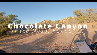
trail: Chocolate Canyon DH, Upper
2:41 |
127 |
Mar 23, 2025 , Kanab
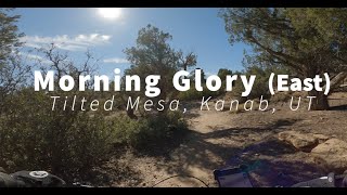
trail: Morning Glory, East
5:30 |
167 |
Dec 12, 2024 , Kanab
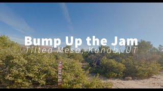
trail: Bump Up The Jam
88 |
Nov 16, 2024 , Kanab
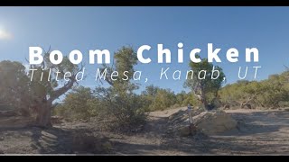
trail: Boom Chicken
122 |
Nov 16, 2024 , Kanab
trail: Middle Earth, Upper
6:51 |
95 |
Nov 12, 2024 , Kanab
Recent Trail Reports
| status | trail | date | condition | info | user |
|---|---|---|---|---|---|
| Tom's Canyon | May 17, 2026 @ 7:24pm (America/Denver) May 17, 2026 | Dry | dr-reveg | ||
| Low Road | Apr 12, 2026 @ 5:01pm (America/Denver) Apr 12, 2026 | Ideal | ktmken | ||
| Tilted Mesa Road | Dec 20, 2025 @ 11:29am (America/Phoenix) Dec 20, 2025 | Ideal | mountainmaneuvers | ||
| Western Legend, Lower | Dec 20, 2025 @ 11:29am (America/Phoenix) Dec 20, 2025 | Ideal | mountainmaneuvers | ||
| Shinabump | Dec 20, 2025 @ 11:29am (America/Phoenix) Dec 20, 2025 | Ideal | mountainmaneuvers | ||
| Bump Up The Jam | Dec 20, 2025 @ 11:29am (America/Phoenix) Dec 20, 2025 | Ideal | mountainmaneuvers | ||
| Western Legend | Dec 20, 2025 @ 11:29am (America/Phoenix) Dec 20, 2025 | Ideal | mountainmaneuvers | ||
| Western Legend, Middle | Dec 20, 2025 @ 11:29am (America/Phoenix) Dec 20, 2025 | Ideal | mountainmaneuvers | ||
| Oh My Heck | Dec 20, 2025 @ 11:29am (America/Phoenix) Dec 20, 2025 | Ideal | mountainmaneuvers | ||
| Western Legend, Upper | Dec 20, 2025 @ 11:29am (America/Phoenix) Dec 20, 2025 | Ideal | mountainmaneuvers |
National Scenic Trails & Official Routes
-
Great Western Trail
- Mountain Bike
- E-Bike
- Horse
- Hike
- Trail Running
- Dirtbike/Moto
- ATV/ORV/OHV

Activity Feed
| username | action | type | title | date |
|---|---|---|---|---|
| slewandowski | wishlist | region | activity #97232733 | Jun 17, 2026 @ 10:15pm 10 hours |
| WuzzyTriNitro | wishlist | trail | activity #95377549 | May 23, 2026 @ 8:56pm May 23, 2026 |
| dr-reveg | add | report | activity #94954422 | May 17, 2026 @ 6:24pm May 17, 2026 |
| Bmrasmus | ridden | trail | activity #94789339 | May 15, 2026 @ 9:37pm May 15, 2026 |
| LRay999 | wishlist | region | activity #94436981 | May 10, 2026 @ 9:49am May 10, 2026 |
Recent Comments
| username | type | title | comment | date |
|---|---|---|---|---|
| trail | None of previous comments tell us anything... | May 12, 2026 @ 8:34pm May 12, 2026 | ||
| trail | Clockwise leads to a nice knoll climb about... | May 3, 2026 @ 5:08pm May 3, 2026 | ||
| trail | Meet Dan on the trail. Thank you so much for... | Apr 22, 2026 @ 10:36am Apr 22, 2026 | ||
| trail | Trail in great condition. A few man made... | Mar 9, 2026 @ 4:53pm Mar 9, 2026 | ||
| trail | Trail ratings are local, and compared to the... | Nov 24, 2025 @ 6:40pm Nov 24, 2025 |
Local Badges
-

Epic Ride Climb 2k6 awarded -

Climbing 10k Badge3 awarded -

Climbing 100k Badge0 awarded -

Epic Ride Descent 2k6 awarded -

Descent 10k Badge3 awarded -

Descent 100k Badge0 awarded
Activity Type Stats
| activitytype | trails | distance | descent | descent distance | total vertical | rating | global rank | state rank | photos | reports | routes | ridelogs |
|---|---|---|---|---|---|---|---|---|---|---|---|---|
| Mountain Bike | 64 | 199 miles | 15,486 ft | 91 miles | 3,340 ft | #1,196 | #464 | 124 | 277 | 1 | 1,969 | |
| E-Bike | 50 | 121 miles | 8,287 ft | 50 miles | 3,087 ft | #1,301 | #847 | 254 | 335 | |||
| Horse | 32 | 161 miles | 14,403 ft | 74 miles | 3,281 ft | #130 | #385 | 33 | 20 | 1 | 2 | |
| Hike | 109 | 320 miles | 29,226 ft | 150 miles | 3,730 ft | #210 | #108 | 62 | 282 | 2 | 2,930 | |
| Trail Running | 94 | 280 miles | 24,373 ft | 132 miles | 3,730 ft | #530 | #203 | 279 | 1 | 496 | ||
| Dirtbike/Moto | 22 | 149 miles | 9,327 ft | 62 miles | 3,087 ft | #200 | #116 | 12 | 1 | 12 | ||
| ATV/ORV/OHV | 21 | 143 miles | 9,180 ft | 61 miles | 3,087 ft | #104 | #54 | 13 | 1 | 38 | ||
| Snowshoe | 2 | 3,389 ft | 26 ft | 1,942 ft | 1,355 ft | |||||||
| Nordic Ski | 1 | 2,005 ft | 26 ft | 1,942 ft | 30 ft |
Frequently Asked Questions About Kanab
▼
What are the best places to ride in Kanab?
Kanab has 4 areas to explore for mountain biking. The top rated areas are:
▼
What are the highest rated mountain biking trails in Kanab?
The highest rated mountain biking trails in Kanab are:
- Chocolate Canyon DH, Lower (4.4/5)
- Western Legend (4.3/5)
- Morning Glory, East (4.3/5)
- Morning Glory, West (4.3/5)
- Western Legend, Upper (4.2/5)
▼
What is the best time of the year to ride in Kanab?
Based on ride log data, the most popular months to ride in Kanab are:
- October (17 activities)
- April (14 activities)
- December (10 activities)
▼
Where can I park to ride in Kanab?
There are 29 parking locations listed in Kanab. The most popular parking spots are: View all parking and trailhead locations on the map to plan your visit.
Activities
Trails
Points of Interest
- Dinosaur Tracks Sight
- Elkheart Cliffs Slot Canyon Sight
- Peekaboo Slot Canyon Sight
- Moqui Caves Sight
- Skylight Arch Sight
- 12" Jump TTF
- Wooden Ramp Boardwalk
- Pahreah (Paria) Ghost Town Sight
- Winter Road [Trailhead] Other
- Coral Pink Sand Dunes South Campground Camping
- Dianas Throne (7,014 ft)
- Timber Mountain (6,959 ft)
- Jodys Knoll (6,847 ft)
- By ocdune & contributors
- Admins: jkwilliamz, UtahJohn, jpmcghee, jasonmalczyk
- #10211 - 24,647 views
- kanab activity log | embed map of Kanab mountain bike trails | kanab mountain biking points of interest
Downloading of trail gps tracks in kml & gpx formats is enabled for Kanab.
You must login to download files.