close
-
Layers w
- Weather Layers
- Pro
- Pro
- Pro
- Pro
- Pro
- Pro
- More Layers
- Pro
- Pro
- Pro
- Pro
-
Upgrade to

3D
Trail Conditions
- Unknown
- Snow Groomed
- Snow Packed
- Snow Covered
- Snow Cover Partial
- Freeze/thaw Cycle
- Icy
- Prevalent Mud
- Wet
- Variable
- Ideal
- Dry
- Very Dry
Trail Flow (Ridden Direction)
Trailforks scans users ridelogs to determine the most popular direction each trail is ridden. A good flowing trail network will have most trails flowing in a single direction according to their intension.
The colour categories are based on what percentage of riders are riding a trail in its intended direction.
The colour categories are based on what percentage of riders are riding a trail in its intended direction.
- > 96%
- > 90%
- > 80%
- > 70%
- > 50%
- < 50%
- bi-directional trail
- no data
Trail Last Ridden
Trailforks scans ridelogs to determine the last time a trail was ridden.
- < 2 days
- < 1 week
- < 2 weeks
- < 1 month
- < 6 months
- > 6 months
Trail Ridden Direction
The intended direction a trail should be ridden.
- Downhill Only
- Downhill Primary
- Both Directions
- Uphill Primary
- Uphill Only
- One Direction
Contribute Details
Colors indicate trail is missing specified detail.
- Description
- Photos
- Description & Photos
- Videos
Trail Popularity ?
Trailforks scans ridelogs to determine which trails are ridden the most in the last 9 months.
Trails are compared with nearby trails in the same city region with a possible 25 colour shades.
Think of this as a heatmap, more rides = more kinetic energy = warmer colors.
- most popular
- popular
- less popular
- not popular
ATV/ORV/OHV Filter
Max Vehicle Width
inches
US Cell Coverage
Legend

Radar Time
Activity Recordings
Trailforks uses anonymized public activity data.
?
Activity Recordings
Trailforks uses anonymized public activity data.
?
Personal Heatmap
▶
Activity Types
all
/
none
▶
Options
2
Date range
month
–
Winter Trails
Warning
A routing network for winter maps does not exist. Selecting trails using the winter trails layer has been disabled.
Missing Trails
Most Popular
Least Popular
Trails are colored based on popularity. The more popular a trail is, the more red. Less popular trails trend towards green.
Jump Magnitude Heatmap
Heatmap of where riders jump on trails. Zoom in to see individual jumps, click circles to view jump details.
BC Backroad Status
![map legend]()
Service Road Atlas is a free to use, community-driven service for viewing and creating reports on the numerous back-country service roads around B.C. and Alberta.

Slope Aspect
Direction the slope faces
Trails Deemphasized
Trails are shown in grey.
Only show trails with no bike usage.
Suggested Layers
Based on selected activity type
Save the current map location and zoom level as your default home location whenever this page is loaded.
Save
No description for Kanata has been added yet!
Login or register to submit one.
Activities Click to view
- Mountain Bike
40 trails
- E-Bike
38 trails
- Gravel Bike
0 trails
- Adaptive Bike
0 trails
- Winter Fat Bike
0 trails
- Hike
40 trails
- Trail Running
40 trails
- Snowshoe
34 trails
- Backcountry Ski
33 trails
Region Details
- 4
- 2
- 13
- 14
- 3
- 1
Region Status
Open as of Jun 13, 2026Stats
- Avg Trail Rating
- Trails (view details)
- 37
- Trails Mountain Bike
- 40
- Trails E-Bike
- 38
- Trails Hike
- 40
- Trails Trail Running
- 40
- Trails Snowshoe
- 34
- Trails Backcountry Ski
- 33
- Total Distance
- 18 miles
- Total Descent
- 547 ft
- Total Vertical
- 108 ft
- Highest Trailhead
- 406 ft
- Reports
- 2,326
- Photos
- 262
- Ridden Counter
- 20,986
Sub Regions
-
South March Highlands
- 1
- 13
- 14
- 3
- 1
Popular Kanata Mountain Biking Trails
• 65 ★ 3.4 • 2,953 ft • 8 ft • 1,023 •
This trail would be given an intermediate rating in most other trail networks. The beginner/green rating it has been given is relative to South March Highlands, not relative to trails in general. If you are a beginner, suggest you start...
• 80 ★ 4.0 • 3,304 ft • 15 ft • 1,018 •
A mixture of rocky sections and flow. Can be ridden in either direction, but flows slightly better from east to west. The western end of the trail features a long section of janky rock armouring that will shake your dentures loose. The...
• 75 ★ 3.5 • 1,631 ft • 23 ft • 978 •
Easy beginner trail that starts at the end of . It's wide, straight, mostly flat, and features a few rocks, rock outcroppings, and roots that are ridable at a beginner level.
• 95 ★ 4.1 • 3,543 ft • 6 ft • 976 •
Pete's Wicked Trail (PWT) is more difficult on average than North and , but still has some sections with good flow and speed. The trail name is a reference both to the primary builder (Peter) and the craft beer "Pete's Wicked Ale" that...
• 100 ★ 3.5 • 791 ft • 3 ft • 958 •
A short, mostly cruisy alternative to the greater difficulties of and to the south. This trail was built in 2014 during an workshop hosted by OMBA. It features some benchcut trail construction.
• 90 ★ 4.2 • 1 mile • 14 ft • 947 •
What used to be the old end of , is undeniably harder to ride both directions then . Some nice flowy bits are linked by difficulty technical sections, climbs and short descents, some high consequence. Best ridden from for a gentler ride...
• 95 ★ 4.2 • 1,381 ft • 5 ft • 939 •
A mixture of rocky sections and flow, with a black diamond level feature "Boneyard" towards the eastern end of the trail. This trail is named for the original builder, Mario Theoret. A plaque at the intersection of and trails...
Kanata Mountain Bike Routes
5 miles • 92 ft • 6 •
This is a suggested route for beginners. You'll find the beginner-rated trails harder than beginner-rated...
12 miles • 322 ft • 16 • Loop •
This route takes in most of the single track trails at South March Highlands. Trailforks shows the total...
★ 4.0 • 6 miles • 109 ft • 0 • Point to Point •
This route has some gravel paths, some singletrack, and a few technical areas that have lots of rocks and...
5 miles • 105 ft • 12 • Loop •
A loop of much of the intermediate trails at South March Highlands
9 miles • 175 ft • 9 • Loop •
May or may not be a race course! We don't know yet but hopefully in the near future!
7 miles • 133 ft • 0 • Loop •
This is a great loop for riders with strong intermediate skills. Beginner or low intermediate riders will...
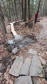
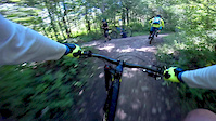
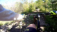
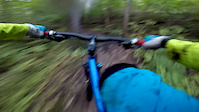
Photos of Kanata Mountain Bike
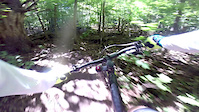
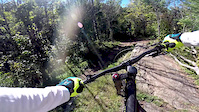
Videos of Kanata Mountain Bike
trail: Coconut Tree
0:19 |
44 |
Nov 18, 2024
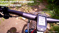
trail: North Dogsled
0:20 |
221 |
Jan 18, 2020
trail: North Dogsled
0:05 |
492 |
Nov 2, 2014
trail: North Dogsled
0:57 |
368 |
Oct 23, 2014
trail: North Dogsled
0:48 |
350 |
Oct 21, 2014
trail: North Dogsled
0:28 |
350 |
Oct 20, 2014
trail: South Dogsled
0:39 |
417 |
Oct 18, 2014

trail: South Dogsled
0:25 |
326 |
Oct 17, 2014
Recent Trail Reports
| status | trail | date | condition | info | user |
|---|---|---|---|---|---|
| PWT (East) | Jun 13, 2026 @ 10:49am (America/Toronto) Jun 13, 2026 | Ideal | varroa | ||
| IMBA | Jun 13, 2026 @ 10:49am (America/Toronto) Jun 13, 2026 | Ideal | varroa | ||
| South Dogsled | Jun 13, 2026 @ 10:49am (America/Toronto) Jun 13, 2026 | Ideal | varroa | ||
| Fast Out | Jun 4, 2026 @ 10:20am (America/Toronto) Jun 4, 2026 | Ideal | kegor | ||
| Ridgetop | Jun 4, 2026 @ 10:20am (America/Toronto) Jun 4, 2026 | Ideal | kegor | ||
| Origins | Jun 4, 2026 @ 10:20am (America/Toronto) Jun 4, 2026 | Ideal | kegor | ||
| Mario's Line | Jun 4, 2026 @ 10:20am (America/Toronto) Jun 4, 2026 | Ideal | kegor | ||
| Beluga | Jun 4, 2026 @ 10:20am (America/Toronto) Jun 4, 2026 | Ideal | kegor | ||
| Rockhopper | Jun 1, 2026 @ 12:01pm (America/Toronto) Jun 1, 2026 | Variable | kdubuc | ||
| PWT (West) | Apr 28, 2026 @ 10:15am (America/Toronto) Apr 28, 2026 | Ideal | kegor |
Activity Feed
| username | action | type | title | date |
|---|---|---|---|---|
| varroa | add | report | activity #96902133 and 2 more | Jun 13, 2026 @ 11:50am Jun 13, 2026 |
| IQvyPM | add | report | activity #96859906 | Jun 13, 2026 @ 3:45am Jun 13, 2026 |
| rayvermette | update | trail | activity #96751767 | Jun 11, 2026 @ 11:33am Jun 11, 2026 |
| rayvermette | update | trail | activity #96700318 | Jun 10, 2026 @ 3:49pm Jun 10, 2026 |
| kegor | add | report | activity #96241424 and 6 more | Jun 4, 2026 @ 11:20am Jun 4, 2026 |
Recent Comments
| username | type | title | comment | date |
|---|---|---|---|---|
| report | Good morning! The first tree was cleared last... | Jun 2, 2026 @ 6:07am Jun 2, 2026 | ||
| report | I took care of the 2nd tree yesterday (around... | Jun 1, 2026 @ 10:48am Jun 1, 2026 | ||
| report | 👍 | Apr 20, 2026 @ 4:35am Apr 20, 2026 | ||
| report | This is now cleared as of July 19, 2025. | Jul 19, 2025 @ 1:41pm Jul 19, 2025 | ||
| trail | Great trail and fun addition to SMH… | Nov 14, 2024 @ 12:25pm Nov 14, 2024 |
Local Badges
-

10 Green Trails330 awarded -

10 Blue Trails459 awarded -

Epic Ride Climb 2k1 awarded -

Climbing 10k Badge31 awarded -

Climbing 100k Badge0 awarded -

Epic Ride Descent 2k1 awarded
Activity Type Stats
| activitytype | trails | distance | descent | descent distance | total vertical | rating | global rank | state rank | photos | reports | routes | ridelogs |
|---|---|---|---|---|---|---|---|---|---|---|---|---|
| Mountain Bike | 40 | 18 miles | 548 ft | 5 miles | 108 ft | #764 | #24 | 255 | 2,318 | 7 | 26,113 | |
| E-Bike | 38 | 17 miles | 535 ft | 4 miles | 108 ft | #3,615 | #66 | 2,123 | 839 | |||
| Hike | 40 | 18 miles | 548 ft | 5 miles | 108 ft | #6,211 | #121 | 5 | 2,312 | 1 | 900 | |
| Trail Running | 40 | 18 miles | 548 ft | 5 miles | 108 ft | #5,780 | #96 | 2 | 2,312 | 1 | 387 | |
| Snowshoe | 34 | 15 miles | 466 ft | 4 miles | 108 ft | #576 | #62 | 828 | 118 | |||
| Backcountry Ski | 33 | 15 miles | 466 ft | 4 miles | 108 ft | #439 | #7 | 483 | 6 |
Frequently Asked Questions About Kanata
▼
What are the best places to ride in Kanata?
Kanata has 2 areas to explore for mountain biking. The top rated areas are:
▼
What are the highest rated mountain biking trails in Kanata?
The highest rated mountain biking trails in Kanata are:
- Ridgetop (4.4/5)
- Staycation (4.3/5)
- Beluga (4.2/5)
- Coconut Tree (4.2/5)
- Shadow's Ridge (4.2/5)
▼
What is the best time of the year to ride in Kanata?
Based on ride log data, the most popular months to ride in Kanata are:
- May (402 activities)
- July (388 activities)
- June (364 activities)
▼
Where can I park to ride in Kanata?
There are 5 parking locations listed in Kanata. The most popular parking spots are:
- Shoulder Parking - Brady Entrance
- Shoulder Parking - Forestbrook Entrance
- Shoulder Parking - K2 Trailhead Entrance
- Parking
- Parking
Activities
Trails
- By brenthillier
 NSMBA TRAILFORKS & contributors
 - Admins: OMBA, Br1ngiton
- #3658 - 24,235 views
- kanata activity log | embed map of Kanata mountain bike trails | kanata mountain biking points of interest
Downloading of trail gps tracks in kml & gpx formats is enabled for Kanata.
You must login to download files.