close
-
Layers w
- Weather Layers
- Pro
- Pro
- Pro
- Pro
- Pro
- Pro
- More Layers
- Pro
- Pro
- Pro
- Pro
-
Upgrade to

3D
Trail Conditions
- Unknown
- Snow Groomed
- Snow Packed
- Snow Covered
- Snow Cover Partial
- Freeze/thaw Cycle
- Icy
- Prevalent Mud
- Wet
- Variable
- Ideal
- Dry
- Very Dry
Trail Flow (Ridden Direction)
Trailforks scans users ridelogs to determine the most popular direction each trail is ridden. A good flowing trail network will have most trails flowing in a single direction according to their intension.
The colour categories are based on what percentage of riders are riding a trail in its intended direction.
The colour categories are based on what percentage of riders are riding a trail in its intended direction.
- > 96%
- > 90%
- > 80%
- > 70%
- > 50%
- < 50%
- bi-directional trail
- no data
Trail Last Ridden
Trailforks scans ridelogs to determine the last time a trail was ridden.
- < 2 days
- < 1 week
- < 2 weeks
- < 1 month
- < 6 months
- > 6 months
Trail Ridden Direction
The intended direction a trail should be ridden.
- Downhill Only
- Downhill Primary
- Both Directions
- Uphill Primary
- Uphill Only
- One Direction
Contribute Details
Colors indicate trail is missing specified detail.
- Description
- Photos
- Description & Photos
- Videos
Trail Popularity ?
Trailforks scans ridelogs to determine which trails are ridden the most in the last 9 months.
Trails are compared with nearby trails in the same city region with a possible 25 colour shades.
Think of this as a heatmap, more rides = more kinetic energy = warmer colors.
- most popular
- popular
- less popular
- not popular
ATV/ORV/OHV Filter
Max Vehicle Width
inches
US Cell Coverage
Legend

Radar Time
Activity Recordings
Trailforks uses anonymized public activity data.
?
Activity Recordings
Trailforks uses anonymized public activity data.
?
Personal Heatmap
▶
Activity Types
all
/
none
▶
Options
2
Date range
month
–
Winter Trails
Warning
A routing network for winter maps does not exist. Selecting trails using the winter trails layer has been disabled.
Missing Trails
Most Popular
Least Popular
Trails are colored based on popularity. The more popular a trail is, the more red. Less popular trails trend towards green.
Jump Magnitude Heatmap
Heatmap of where riders jump on trails. Zoom in to see individual jumps, click circles to view jump details.
BC Backroad Status
![map legend]()
Service Road Atlas is a free to use, community-driven service for viewing and creating reports on the numerous back-country service roads around B.C. and Alberta.

Slope Aspect
Direction the slope faces
Trails Deemphasized
Trails are shown in grey.
Only show trails with no bike usage.
Suggested Layers
Based on selected activity type
Save the current map location and zoom level as your default home location whenever this page is loaded.
Save
No description for Karnataka has been added yet!
Login or register to submit one.
Region Details
- 1
- 2
- 1
Stats
- Avg Trail Rating
- Trails (view details)
- 4
- Trails Mountain Bike
- 4
- Trails E-Bike
- 1
- Trails Hike
- 4
- Trails Trail Running
- 4
- Total Distance
- 2 miles
- Total Descent
- 327 ft
- Total Vertical
- 288 ft
- Highest Trailhead
- 3,096 ft
- Reports
- 5
- Photos
- 3
- Ridden Counter
- 20
Sub Regions
- Bangalore (4)
- Avalahalli Forest (2)
- Nandi Hills (1)
- Tamil Nadu (0)
- Turahalli Forest (1)
Popular Karnataka Mountain Biking Trails
• 100 ★ 0.0 • 3,889 ft • 40 ft • 7 •
Undulating singletrack with loose pebbles, baby heads, rock gardens, and leaves in the winter.
• 5 ★ 0.0 • 0 ft • 0 ft • 2 •
Less popular blue difficulty singletrack. This mountain bike primary trail can be used both directions and has a moderate overall physical rating with a 0 ft blue climb. It features drop and jump. Trail visibility is sometimes hard to follow.
• 5 ★ 5.0 • 4,150 ft • 4 ft • 1 •
One of the very few Forests around Bangalore that is still popular among Mountain Bikers. This is the First fun trail in the loop
Karnataka Mountain Bike Routes
37 miles • 1,359 ft • 0 •
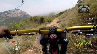
Videos of Karnataka Mountain Bike
3:12 |
302 |
Aug 15, 2016
3:53 |
326 |
May 23, 2015
trail: Nandi Bull
6:38 |
1534 |
Jun 3, 2019 , Bangalore

trail: Nandi Bull
2:38 |
515 |
Jun 3, 2019 , Bangalore
Recent Trail Reports
no previous reports, add one now!
Activity Feed
| username | action | type | title | date |
|---|---|---|---|---|
| PJ11 | wishlist | region | activity #30327666 | Jun 13, 2022 @ 5:19am Jun 13, 2022 |
| nammarider | ridden | trail | activity #27513262 | Mar 14, 2022 @ 2:56am Mar 14, 2022 |
| nammarider | ridden | trail | activity #27513255 | Mar 14, 2022 @ 2:56am Mar 14, 2022 |
| sahilsehgal10 | like | directory | activity #18271883 | Apr 18, 2021 @ 1:42am Apr 18, 2021 |
| sohamdata | like | directory | activity #15511600 | Dec 27, 2020 @ 12:29am Dec 27, 2020 |
Local Mountain Biking Directory
-
Thurahalli
-
Life Behind Bars Cycles
-
BumsonthesaddleBike Shop
-
ProcycleBike Shop
Activity Type Stats
| activitytype | trails | distance | descent | descent distance | total vertical | rating | global rank | state rank | photos | reports | routes | ridelogs |
|---|---|---|---|---|---|---|---|---|---|---|---|---|
| Mountain Bike | 4 | 2 miles | 328 ft | 1 mile | 289 ft | 3 | 5 | 1 | 2,802 | |||
| E-Bike | 1 | 4,150 ft | 194 ft | 3,383 ft | 190 ft | 5 | 24 | |||||
| Hike | 4 | 2 miles | 328 ft | 1 mile | 289 ft | 5 | 165 | |||||
| Trail Running | 4 | 2 miles | 328 ft | 1 mile | 289 ft | 5 | 53 |
- By brenthillier
 NSMBA TRAILFORKS & contributors
 - Admins: apply
- #8187 - 3,363 views
- karnataka activity log | embed map of Karnataka mountain bike trails | karnataka mountain biking points of interest
Downloading of trail gps tracks in kml & gpx formats is enabled for Karnataka.
You must login to download files.