close
-
Layers w
- Weather Layers
- Pro
- Pro
- Pro
- Pro
- Pro
- Pro
- More Layers
- Pro
- Pro
- Pro
- Pro
-
Upgrade to

3D
Trail Conditions
- Unknown
- Snow Groomed
- Snow Packed
- Snow Covered
- Snow Cover Partial
- Freeze/thaw Cycle
- Icy
- Prevalent Mud
- Wet
- Variable
- Ideal
- Dry
- Very Dry
Trail Flow (Ridden Direction)
Trailforks scans users ridelogs to determine the most popular direction each trail is ridden. A good flowing trail network will have most trails flowing in a single direction according to their intension.
The colour categories are based on what percentage of riders are riding a trail in its intended direction.
The colour categories are based on what percentage of riders are riding a trail in its intended direction.
- > 96%
- > 90%
- > 80%
- > 70%
- > 50%
- < 50%
- bi-directional trail
- no data
Trail Last Ridden
Trailforks scans ridelogs to determine the last time a trail was ridden.
- < 2 days
- < 1 week
- < 2 weeks
- < 1 month
- < 6 months
- > 6 months
Trail Ridden Direction
The intended direction a trail should be ridden.
- Downhill Only
- Downhill Primary
- Both Directions
- Uphill Primary
- Uphill Only
- One Direction
Contribute Details
Colors indicate trail is missing specified detail.
- Description
- Photos
- Description & Photos
- Videos
Trail Popularity ?
Trailforks scans ridelogs to determine which trails are ridden the most in the last 9 months.
Trails are compared with nearby trails in the same city region with a possible 25 colour shades.
Think of this as a heatmap, more rides = more kinetic energy = warmer colors.
- most popular
- popular
- less popular
- not popular
ATV/ORV/OHV Filter
Max Vehicle Width
inches
US Cell Coverage
Legend

Radar Time
Activity Recordings
Trailforks uses anonymized public activity data.
?
Activity Recordings
Trailforks uses anonymized public activity data.
?
Personal Heatmap
▶
Activity Types
all
/
none
▶
Options
2
Date range
month
–
Winter Trails
Warning
A routing network for winter maps does not exist. Selecting trails using the winter trails layer has been disabled.
Missing Trails
Most Popular
Least Popular
Trails are colored based on popularity. The more popular a trail is, the more red. Less popular trails trend towards green.
Jump Magnitude Heatmap
Heatmap of where riders jump on trails. Zoom in to see individual jumps, click circles to view jump details.
BC Backroad Status
![map legend]()
Service Road Atlas is a free to use, community-driven service for viewing and creating reports on the numerous back-country service roads around B.C. and Alberta.

Slope Aspect
Direction the slope faces
Trails Deemphasized
Trails are shown in grey.
Only show trails with no bike usage.
Suggested Layers
Based on selected activity type
Save the current map location and zoom level as your default home location whenever this page is loaded.
Save
No description for Karpacz has been added yet!
Login or register to submit one.
This region uses the Uk/Euro style trail grading system.
Activities Click to view
- Mountain Bike
48 trails
- E-Bike
48 trails
- Gravel Bike
0 trails
- Adaptive Bike
0 trails
- Hike
60 trails
- Trail Running
60 trails
- Downhill Ski
2 trails
Region Details
- 17
- 9
- 17
- 2
Region Status
Caution as of Jun 7, 2026Stats
- Avg Trail Rating
- Trails (view details)
- 77
- Trails Mountain Bike
- 48
- Trails E-Bike
- 48
- Trails Hike
- 60
- Trails Trail Running
- 60
- Trails Downhill Ski
- 2
- Trails Backcountry Ski
- 1
- Total Distance
- 85 miles
- Total Descent
- 28,762 ft
- Total Vertical
- 3,775 ft
- Highest Trailhead
- 5,221 ft
- Reports
- 120
- Photos
- 241
- Ridden Counter
- 5,164
Sub Regions
-
Grabowiec
- 3
- 5
-
Karkonosze
- 2
- 1
Popular Karpacz Mountain Biking Trails
• 95 ★ 3.7 • 5,207 ft • 0 ft • 97 • • hike
Zielony szlak z Karpacza do Borowic. Pierwsza część łatwiejsza, dość dużo kamieni, w drugiej pojawiają się uskoki i inne ciekawe atrakcje. Kilka dropów dla chętnych.
• 90 ★ 5.0 • 810 ft • 0 ft • 51 •
Popular red difficulty wilderness trail. This mountain bike primary trail can be used downhill only. It features drop, jump and rock garden. On average it takes 2 minutes to complete this trail.
• 100 ★ 5.0 • 2,799 ft • 0 ft • 51 •
Popular black difficulty wilderness trail. This mountain bike primary trail and has a hard overall physical rating. It features berm, drop, jump, rock face, rock garden and other. Trail visibility is sometimes hard to follow. On average it takes 14 minutes to complete this trail.
• 60 ★ 0.0 • 3,002 ft • 0 ft • 49 •
Moderately popular blue difficulty singletrack. This mountain bike primary trail can be used downhill only. It features berm, jump and other. On average it takes 1 minutes to complete this trail.
• 70 ★ 0.0 • 1,345 ft • 0 ft • 38 •
Popular red difficulty wilderness trail. This multi-use trail can be used downhill only. It features rock garden. On average it takes 3 minutes to complete this trail.
• 80 ★ 5.0 • 3,940 ft • 0 ft • 29 •
Popular red difficulty singletrack. This mountain bike primary trail and has a moderate overall physical rating. It features drop. Trail visibility is always easy to follow.
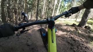
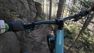
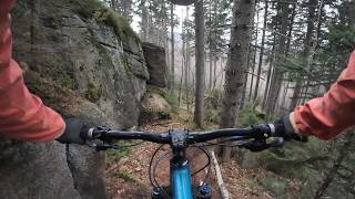
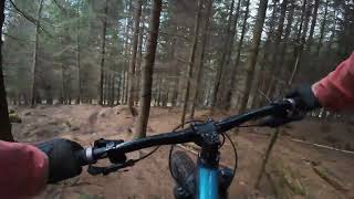
Photos of Karpacz Mountain Bike
Videos of Karpacz Mountain Bike
trail: Krzesełko
5:14 |
31 |
May 5, 2026 , Karpacz
trail: gRzeczna
7:44 |
58 |
May 5, 2026 , Karpacz
trail: gRzeczna
9:05 |
71 |
Apr 9, 2026 , Karpacz
trail: Krzesełko
7:21 |
35 |
Apr 7, 2026 , Karpacz

trail: Dzika
8:21 |
147 |
Aug 18, 2025 , Karpacz
trail: Zielony do Borowic
8:10 |
153 |
Jun 5, 2023 , Karpacz
Current Trail Warnings
| status | trail | date | condition | user | info |
|---|---|---|---|---|---|
| Jaźwiec | Jun 7, 2026 @ 9:07am (Europe/Warsaw) Jun 7, 2026 | Unknown | kubabike | E-Bike Nie używana trasa, dolna część... |
Recent Trail Reports
| status | trail | date | condition | info | user |
|---|---|---|---|---|---|
| Dzika | May 23, 2026 @ 8:41pm (Europe/Warsaw) May 23, 2026 | Ideal | BombaJJ | ||
| Kotki | May 2, 2026 @ 9:36am (Europe/Warsaw) May 2, 2026 | Dry | Minefield | ||
| Husyta | May 2, 2026 @ 9:36am (Europe/Warsaw) May 2, 2026 | Dry | Minefield | ||
| Zielony do Borowic | May 1, 2026 @ 9:48am (Europe/Warsaw) May 1, 2026 | Dry | Minefield | ||
| gRzeczna | May 1, 2026 @ 11:52pm (Europe/Warsaw) May 1, 2026 | Ideal | majatravels | ||
| Forficzer | May 1, 2026 @ 11:50pm (Europe/Warsaw) May 1, 2026 | Unknown | majatravels | ||
| Krzesełko | Nov 6, 2025 @ 2:08pm (Europe/Prague) Nov 6, 2025 | Variable | mloskot | ||
| Droga Chomontowa | Oct 3, 2025 @ 2:50pm (Europe/Prague) Oct 3, 2025 | Ideal | RiFFu | ||
| Pieski | Aug 26, 2025 @ 3:13pm Aug 26, 2025 | Unknown | r85 | ||
| Grabowiec Szczytowy | Aug 17, 2025 @ 12:00pm Aug 17, 2025 | Dry | r85 |
Activity Feed
| username | action | type | title | date |
|---|---|---|---|---|
| AdamhHNzuz | wishlist | trail | activity #96730278 | Jun 11, 2026 @ 5:21am Jun 11, 2026 |
| kubabike | add | report | activity #96536458 | Jun 8, 2026 @ 6:53am Jun 8, 2026 |
| drajvver | wishlist | trail | activity #96350941 | Jun 6, 2026 @ 2:52am Jun 6, 2026 |
| Tom-501 | wishlist | trail | activity #95971729 | May 31, 2026 @ 1:09pm May 31, 2026 |
| Tom-501 | wishlist | region | activity #95971692 | May 31, 2026 @ 1:08pm May 31, 2026 |
Recent Comments
| username | type | title | comment | date |
|---|---|---|---|---|
| trail | Cudne, strome, techniczne. Razem z pobliskimi... | Nov 7, 2025 @ 4:51am Nov 7, 2025 | ||
| trail | Traska na ten moment rozwalona wycinką...... | Sep 13, 2025 @ 8:21am Sep 13, 2025 | ||
| trail | Sztos! Zwłaszcza ten skalny fragment z deską... | Sep 8, 2025 @ 7:33am Sep 8, 2025 | ||
| trail | Bardzo krótka trasa, a jednocześnie bardzo... | Sep 8, 2025 @ 7:18am Sep 8, 2025 | ||
| report | piekna trasa | Aug 27, 2025 @ 2:28am Aug 27, 2025 |
Local Badges
-

Epic Ride Climb 2k43 awarded -

Climbing 10k Badge7 awarded -

Climbing 100k Badge0 awarded -

Epic Ride Descent 2k43 awarded -

Descent 10k Badge8 awarded -

Descent 100k Badge0 awarded
Activity Type Stats
| activitytype | trails | distance | descent | descent distance | total vertical | rating | global rank | state rank | photos | reports | routes | ridelogs |
|---|---|---|---|---|---|---|---|---|---|---|---|---|
| Mountain Bike | 48 | 39 miles | 17,123 ft | 23 miles | 2,477 ft | #2,359 | #41 | 238 | 120 | 1,394 | ||
| E-Bike | 48 | 39 miles | 17,123 ft | 23 miles | 2,477 ft | #1,767 | #282 | 115 | 240 | |||
| Hike | 60 | 75 miles | 19,416 ft | 36 miles | 3,776 ft | #529 | #30 | 3 | 102 | 2,839 | ||
| Trail Running | 60 | 75 miles | 19,416 ft | 36 miles | 3,776 ft | #1,426 | #33 | 102 | 150 | |||
| Downhill Ski | 2 | 5,033 ft | 627 ft | 5,033 ft | 1,060 ft | #231 | #19 | 175 | ||||
| Backcountry Ski | 1 | 1,988 ft | 404 ft | 1,988 ft | 404 ft | #743 | 60 |
Frequently Asked Questions About Karpacz
▼
What are the best places to ride in Karpacz?
Karpacz has 3 areas to explore for mountain biking. The top rated areas are:
▼
What are the highest rated mountain biking trails in Karpacz?
▼
What is the best time of the year to ride in Karpacz?
Based on ride log data, the most popular months to ride in Karpacz are:
- August (7 activities)
- October (7 activities)
- June (6 activities)
▼
Where can I park to ride in Karpacz?
Check the Karpacz trail map for trailhead and parking information. Community members regularly update access and parking details for trails in the area.
Activities
Trails
Points of Interest
- Schronisko Dom Śląski Cabin
- Schronisko Samotnia Cabin
- Schronisko Strzecha Akademicka Cabin
- Punkt widokowy na Dolinę Pląsawy Viewpoint
- Schronisko Odrodzenie Cabin
- Punkt widokowy na Mały Staw i Samotnię Viewpoint
- Punkt widokowy na Wielki Staw Viewpoint
- Słonecznik Sight
- Pielgrzymy Sight
- Schronisko Kamieńczyk Cabin
- Śnieżka / Sněžka (1,597 m)
- Luční hora (1,550 m)
- Smogornia / Stříbrný hřbet (1,488 m)
- By micolai
 TRAILFORKS Poland & contributors
 - Admins: xaoo
- #17528 - 9,912 views
- karpacz activity log | embed map of Karpacz mountain bike trails | karpacz mountain biking points of interest polygons
Downloading of trail gps tracks in kml & gpx formats is enabled for Karpacz.
You must login to download files.