close
-
Layers w
- Weather Layers
- Pro
- Pro
- Pro
- Pro
- Pro
- Pro
- More Layers
- Pro
- Pro
- Pro
- Pro
-
Upgrade to

3D
Trail Conditions
- Unknown
- Snow Groomed
- Snow Packed
- Snow Covered
- Snow Cover Partial
- Freeze/thaw Cycle
- Icy
- Prevalent Mud
- Wet
- Variable
- Ideal
- Dry
- Very Dry
Trail Flow (Ridden Direction)
Trailforks scans users ridelogs to determine the most popular direction each trail is ridden. A good flowing trail network will have most trails flowing in a single direction according to their intension.
The colour categories are based on what percentage of riders are riding a trail in its intended direction.
The colour categories are based on what percentage of riders are riding a trail in its intended direction.
- > 96%
- > 90%
- > 80%
- > 70%
- > 50%
- < 50%
- bi-directional trail
- no data
Trail Last Ridden
Trailforks scans ridelogs to determine the last time a trail was ridden.
- < 2 days
- < 1 week
- < 2 weeks
- < 1 month
- < 6 months
- > 6 months
Trail Ridden Direction
The intended direction a trail should be ridden.
- Downhill Only
- Downhill Primary
- Both Directions
- Uphill Primary
- Uphill Only
- One Direction
Contribute Details
Colors indicate trail is missing specified detail.
- Description
- Photos
- Description & Photos
- Videos
Trail Popularity ?
Trailforks scans ridelogs to determine which trails are ridden the most in the last 9 months.
Trails are compared with nearby trails in the same city region with a possible 25 colour shades.
Think of this as a heatmap, more rides = more kinetic energy = warmer colors.
- most popular
- popular
- less popular
- not popular
ATV/ORV/OHV Filter
Max Vehicle Width
inches
US Cell Coverage
Legend

Radar Time
Activity Recordings
Trailforks uses anonymized public activity data.
?
Activity Recordings
Trailforks uses anonymized public activity data.
?
Personal Heatmap
▶
Activity Types
all
/
none
▶
Options
2
Date range
month
–
Winter Trails
Warning
A routing network for winter maps does not exist. Selecting trails using the winter trails layer has been disabled.
Missing Trails
Most Popular
Least Popular
Trails are colored based on popularity. The more popular a trail is, the more red. Less popular trails trend towards green.
Jump Magnitude Heatmap
Heatmap of where riders jump on trails. Zoom in to see individual jumps, click circles to view jump details.
BC Backroad Status
![map legend]()
Service Road Atlas is a free to use, community-driven service for viewing and creating reports on the numerous back-country service roads around B.C. and Alberta.

Slope Aspect
Direction the slope faces
Trails Deemphasized
Trails are shown in grey.
Only show trails with no bike usage.
Suggested Layers
Based on selected activity type
Save the current map location and zoom level as your default home location whenever this page is loaded.
Save
No description for Kazakhstan has been added yet!
Login or register to submit one.
Region Details
- 5
- 1
- 1
Stats
- Avg Trail Rating
- Trails (view details)
- 7
- Trails Mountain Bike
- 7
- Trails E-Bike
- 2
- Trails Hike
- 4
- Trails Trail Running
- 4
- Total Distance
- 56 miles
- Total Descent
- 2,846 ft
- Total Vertical
- 5,782 ft
- Highest Trailhead
- 9,278 ft
- Reports
- 3
- Photos
- 11
- Ridden Counter
- 10
Articles
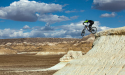
Video: Freeride on Otherworldly Desert Terrain in Kazakhstan
Jan 22, 2020 from pinkbike.com
Petr Vinokurov rides unique lines in the Kazakhstan desert.
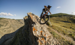
Video: Incredible Natural Landscapes of Russia & Kazakhstan in the Trailer for ‘Spirit of Freedom’
Jan 2, 2020 from pinkbike.com
Travelling across the gorgeous landscapes of Russia and Kazakhstan and riding mountain bikes.
Sub Regions
- Almaty (3)
- Jaguar Bike Park (1)
- Shymbulak (2)
- Atyrau (4)
- Ural River (0)
Popular Kazakhstan Mountain Biking Trails
• 5 ★ 5.0 • 3,110 ft • 34 ft • 3 •
As of June 2019, this trail has not been maintained. It was overgrown, but the remnants of the trail (including two small jumps and several switchbacks) are still there. It’s a fun, although short downhill run. It’s not too much to...
• 5 ★ 5.0 • 1 mile • 0 ft • 3 •
Черная трасса на горнолыжном курорте Чимбулак, спонсируемая Gorilla energy.
• 5 ★ 0.0 • 2,608 ft • 0 ft • 2 •
Трасса находится справа на развилке и представляет из себя множество контр уклонов с двумя прыжками и довольно сложным...
• 5 ★ 0.0 • 20 miles • 30 ft •
When the Ural River freezes in winter this loop is accessible. The loop can be done in either direction. Be careful where the trail splits as the currents can thin the ice near shore.
• 5 ★ 0.0 • 6 miles • 8 ft •
East Canal is accessible during winter when the river and it's tributaries are frozen. This track goes all the way to a border guard station where you must turn around.
• 5 ★ 0.0 • 7 miles • 14 ft •
is an iconic track used by Atyrau Outdoors. The loop begins at the pedestrian bridge and goes through town along the banks of the Ural River. After some distance the tracks enter the steppe and follow along tracks on the levee system...
Kazakhstan Mountain Bike Routes
19 miles • 62 ft • 0 • Loop •
Regular evening loop ride done by local club Atyrau Outdoors
Photos of Kazakhstan Mountain Bike
Recent Comments
| username | type | title | comment | date |
|---|---|---|---|---|
| trail | Bikepark closed as of 2025 | May 8, 2026 @ 3:20pm May 8, 2026 | ||
| trail | https://www.instagram.com/gorilla_chimba_park/ | Aug 9, 2023 @ 6:08am Aug 9, 2023 |
Activity Type Stats
| activitytype | trails | distance | descent | descent distance | total vertical | rating | global rank | state rank | photos | reports | routes | ridelogs |
|---|---|---|---|---|---|---|---|---|---|---|---|---|
| Mountain Bike | 7 | 56 miles | 2,848 ft | 9 miles | 5,781 ft | #92 | 11 | 3 | 1 | 1,247 | ||
| E-Bike | 2 | 2 miles | 2,451 ft | 2 miles | 1,716 ft | #101 | 2 | 59 | ||||
| Hike | 4 | 41 miles | 371 ft | 6 miles | 312 ft | #100 | 3 | 162 | ||||
| Trail Running | 4 | 41 miles | 371 ft | 6 miles | 312 ft | #100 | 3 | 2 |
- By canadaka
 Trailforks & contributors
 - Admins: apply
- #3233 - 7,836 views
- kazakhstan activity log | embed map of Kazakhstan mountain bike trails |
Downloading of trail gps tracks in kml & gpx formats is enabled for Kazakhstan.
You must login to download files.