close
-
Layers w
- Weather Layers
- Pro
- Pro
- Pro
- Pro
- Pro
- Pro
- More Layers
- Pro
- Pro
- Pro
- Pro
-
Upgrade to

3D
Trail Conditions
- Unknown
- Snow Groomed
- Snow Packed
- Snow Covered
- Snow Cover Partial
- Freeze/thaw Cycle
- Icy
- Prevalent Mud
- Wet
- Variable
- Ideal
- Dry
- Very Dry
Trail Flow (Ridden Direction)
Trailforks scans users ridelogs to determine the most popular direction each trail is ridden. A good flowing trail network will have most trails flowing in a single direction according to their intension.
The colour categories are based on what percentage of riders are riding a trail in its intended direction.
The colour categories are based on what percentage of riders are riding a trail in its intended direction.
- > 96%
- > 90%
- > 80%
- > 70%
- > 50%
- < 50%
- bi-directional trail
- no data
Trail Last Ridden
Trailforks scans ridelogs to determine the last time a trail was ridden.
- < 2 days
- < 1 week
- < 2 weeks
- < 1 month
- < 6 months
- > 6 months
Trail Ridden Direction
The intended direction a trail should be ridden.
- Downhill Only
- Downhill Primary
- Both Directions
- Uphill Primary
- Uphill Only
- One Direction
Contribute Details
Colors indicate trail is missing specified detail.
- Description
- Photos
- Description & Photos
- Videos
Trail Popularity ?
Trailforks scans ridelogs to determine which trails are ridden the most in the last 9 months.
Trails are compared with nearby trails in the same city region with a possible 25 colour shades.
Think of this as a heatmap, more rides = more kinetic energy = warmer colors.
- most popular
- popular
- less popular
- not popular
ATV/ORV/OHV Filter
Max Vehicle Width
inches
US Cell Coverage
Legend

Radar Time
Activity Recordings
Trailforks uses anonymized public activity data.
?
Activity Recordings
Trailforks uses anonymized public activity data.
?
Personal Heatmap
▶
Activity Types
all
/
none
▶
Options
2
Date range
month
–
Winter Trails
Warning
A routing network for winter maps does not exist. Selecting trails using the winter trails layer has been disabled.
Missing Trails
Most Popular
Least Popular
Trails are colored based on popularity. The more popular a trail is, the more red. Less popular trails trend towards green.
Jump Magnitude Heatmap
Heatmap of where riders jump on trails. Zoom in to see individual jumps, click circles to view jump details.
BC Backroad Status
![map legend]()
Service Road Atlas is a free to use, community-driven service for viewing and creating reports on the numerous back-country service roads around B.C. and Alberta.

Slope Aspect
Direction the slope faces
Trails Deemphasized
Trails are shown in grey.
Only show trails with no bike usage.
Suggested Layers
Based on selected activity type
Save the current map location and zoom level as your default home location whenever this page is loaded.
Save
No description for Kežmarok has been added yet!
Login or register to submit one.
Activities Click to view
- Mountain Bike
20 trails
- E-Bike
3 trails
- Adaptive Bike
0 trails
- Winter Fat Bike
0 trails
- Hike
44 trails
- Trail Running
39 trails
- Snowshoe
4 trails
- Downhill Ski
12 trails
- Backcountry Ski
18 trails
Region Details
- 8
- 2
- 5
- 4
- 1
Region Status
Open as of May 3, 2026Stats
- Avg Trail Rating
- Trails (view details)
- 55
- Trails Mountain Bike
- 20
- Trails E-Bike
- 3
- Trails Hike
- 44
- Trails Trail Running
- 39
- Trails Snowshoe
- 4
- Trails Downhill Ski
- 12
- Trails Backcountry Ski
- 18
- Total Distance
- 82 miles
- Total Descent
- 34,781 ft
- Total Vertical
- 6,596 ft
- Highest Trailhead
- 8,444 ft
- Reports
- 192
- Photos
- 256
- Ridden Counter
- 5,315
Sub Regions
-
Tatranská Lomnica
- 2
- 3
- 4
Popular Kežmarok Mountain Biking Trails
• 100 ★ 3.0 • 3 miles • 48 ft • 104 •
One and only legal bike trail in National Park Vysoké Tatry. Trail connects Biela Voda with alpine cottage near lake Zelené pleso. Trail is a mix of dirt/gravel road and double track with loads of rocks. Since it's multi-use, note...
• 65 ★ 4.0 • 810 ft • 8 ft • 32 •
Moderately popular green difficulty singletrack. This multi-use trail can be used both directions and has a easy overall physical rating with a 8 ft green climb. On average it takes 3 minutes to complete this trail.
• 80 ★ 0.0 • 3 miles • 386 ft • 26 •
Popular green difficulty family friendly dirt/gravel road. This multi-use trail can be used both directions. On average it takes 21 minutes to complete this trail.
• 55 ★ 0.0 • 3,747 ft • 46 ft • 15 •
Moderately popular white difficulty mixed. This multi-use trail can be used downhill primary and has a easy overall physical rating with a 46 ft green climb. On average it takes 4 minutes to complete this trail.
• 5 ★ 5.0 • 2 miles • 693 ft • 8 • • hike
Less popular blue difficulty alpine wilderness trail. This hike primary trail can be used both directions and has a moderate overall physical rating with a 693 ft blue climb. On average it takes 40 minutes to complete this trail.
• 5 ★ 3.0 • 1 mile • 47 ft • 8 •
Downhill from Cierna Hora, the highest peak of Levocske Vrchy to the red track.
• 5 ★ 0.0 • 2,496 ft • 5 ft • 5 • • hike
Less popular green difficulty singletrack. This hike primary trail can be used downhill primary. On average it takes 14 minutes to complete this trail.
• 50 ★ 0.0 • 2,575 ft • 0 ft • 4 •
Moderately popular double black diamond difficulty singletrack. This mountain bike primary trail can be used both directions. On average it takes 6 minutes to complete this trail.
Kežmarok Mountain Bike Routes
5 miles • 2,176 ft • 2 •
PARKING - DVOR POD PLESMI v Tatranské Matliare výstup na: Chatu pri Zelenom plese, Chata , Veľké Biele...
Photos of Kežmarok Mountain Bike
Videos of Kežmarok Mountain Bike
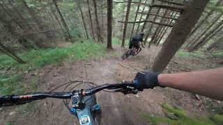
trail: Vert Skalka
8:24 |
33 |
Aug 23, 2025 , Kežmarok
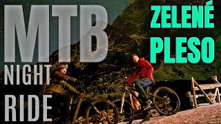
trail: Brnčalka
9:04 |
94 |
Jan 9, 2025 , Kežmarok
youtuber
![Cez Levočské vrchy]()

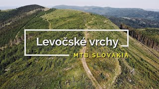
trail: Ciernohorsky chrbat
6:30 |
212 |
Jan 3, 2023 , Kežmarok
Recent Trail Reports
| status | trail | date | condition | info | user |
|---|---|---|---|---|---|
| Brnčalka | Oct 3, 2025 @ 8:16am (Europe/Bratislava) Oct 2, 2025 | Freeze/thaw Cycle | Panek | ||
| Brnčalka access road | Oct 3, 2025 @ 8:16am (Europe/Bratislava) Oct 2, 2025 | Variable | Panek | ||
| Biela Voda | May 31, 2025 @ 9:51am May 31, 2025 | Ideal | tomtoylc | ||
| Čierna voda | Oct 22, 2024 @ 5:07am Oct 22, 2024 | Ideal | tomtoylc | ||
| Hrebienok | Sep 21, 2024 @ 8:45am Sep 21, 2024 | Ideal | tomtoylc | ||
| Plesnivec | Aug 23, 2024 @ 7:33am Aug 23, 2024 | Ideal | tomtoylc | ||
| Lomnický finish | Jun 18, 2024 @ 10:45pm Jun 18, 2024 | Prevalent Mud | imons1Q34H | ||
| Hutnik - Praha | Sep 29, 2023 @ 2:33am Sep 29, 2023 | Ideal | kocnere | ||
| Kafka | Sep 29, 2023 @ 2:33am Sep 29, 2023 | Ideal | kocnere | ||
| Ciernohorsky chrbat | Nov 1, 2022 @ 1:42am Nov 1, 2022 | Ideal | braanoo |
Activity Feed
| username | action | type | title | date |
|---|---|---|---|---|
| jb_tf_spain | wishlist | region | activity #95916889 | May 31, 2026 @ 2:05am May 31, 2026 |
| jbbrenkus | wishlist | trail | activity #95690472 and 1 more | May 28, 2026 @ 12:33am May 28, 2026 |
| NathanbIQmg | wishlist | region | activity #94648685 | May 13, 2026 @ 2:11pm May 13, 2026 |
| Panek | add | report | activity #81816184 and 4 more | Oct 6, 2025 @ 5:37am Oct 6, 2025 |
| amun | add | video | activity #78807153 | Aug 23, 2025 @ 11:46pm Aug 23, 2025 |
Recent Comments
| username | type | title | comment | date |
|---|---|---|---|---|
| trail | Difficult to climb, tecnical. But if you like... | Nov 2, 2022 @ 5:57am Nov 2, 2022 | ||
| trail | Isn’t it Tatra National Park and isn’t it... | Aug 31, 2022 @ 8:35am Aug 31, 2022 | ||
| trail | Veľa kameňov | Aug 26, 2022 @ 2:52am Aug 26, 2022 | ||
| trail | V smere hore je to urcite black diamond, treba... | Jul 26, 2020 @ 1:42pm Jul 26, 2020 | ||
| trail | Aj ked nevie ci take nieco je medzi hutnikom a... | Aug 5, 2019 @ 3:35pm Aug 5, 2019 |
Local Badges
-

Epic Ride Climb 2k67 awarded -

Climbing 10k Badge5 awarded -

Climbing 100k Badge1 awarded -

Epic Ride Descent 2k68 awarded -

Descent 10k Badge5 awarded -

Descent 100k Badge1 awarded
Bike & Skill Parks
| name | type | city | rating |
|---|---|---|---|
| Pumptrack Spišská Belá | skill park | Kežmarok | |
| Pumptrack Kežmarok | skill park | Kežmarok |
Activity Type Stats
| activitytype | trails | distance | descent | descent distance | total vertical | rating | global rank | state rank | photos | reports | routes | ridelogs |
|---|---|---|---|---|---|---|---|---|---|---|---|---|
| Mountain Bike | 20 | 41 miles | 5,410 ft | 13 miles | 3,238 ft | #3,652 | #41 | 233 | 188 | 3 | 1,391 | |
| E-Bike | 3 | 8 miles | 2,313 ft | 4 miles | 2,503 ft | #2,836 | #36 | 186 | 3 | 151 | ||
| Hike | 44 | 76 miles | 28,566 ft | 38 miles | 5,974 ft | #466 | #6 | 23 | 188 | 3 | 2,315 | |
| Trail Running | 39 | 72 miles | 23,665 ft | 35 miles | 5,249 ft | #1,571 | #19 | 188 | 2 | 149 | ||
| Snowshoe | 4 | 5 miles | 3,855 ft | 2 miles | 4,790 ft | #73 | #7 | 4 | 1 | |||
| Downhill Ski | 12 | 7 miles | 6,785 ft | 7 miles | 3,924 ft | #190 | #3 | 4 | 526 | |||
| Backcountry Ski | 18 | 14 miles | 12,270 ft | 11 miles | 5,443 ft | #89 | #6 | 6 | 660 |
Frequently Asked Questions About Kežmarok
▼
What are the best places to ride in Kežmarok?
Kežmarok has 1 areas to explore for mountain biking. The top rated areas are:
▼
What are the highest rated mountain biking trails in Kežmarok?
The highest rated mountain biking trails in Kežmarok are:
- Nad Matliarmi (4.2/5)
- Kafka (4/5)
- Ciernohorsky chrbat (3.8/5)
- Brnčalka (3.5/5)
- Biela Voda (0/5)
▼
What is the best time of the year to ride in Kežmarok?
Based on ride log data, the most popular months to ride in Kežmarok are:
- July (10 activities)
- August (9 activities)
- June (4 activities)
▼
Where can I park to ride in Kežmarok?
There are 2 parking locations listed in Kežmarok. The most popular parking spots are:
Activities
Trails
- By jxxw
 TRAILFORKS & contributors
 - Admins: apply
- #24213 - 2,693 views
- kežmarok activity log | embed map of Kežmarok mountain bike trails | kežmarok mountain biking points of interest
Downloading of trail gps tracks in kml & gpx formats is enabled for Kežmarok.
You must login to download files.