close
-
Layers w
- Weather Layers
- Pro
- Pro
- Pro
- Pro
- Pro
- Pro
- More Layers
- Pro
- Pro
- Pro
- Pro
-
Upgrade to

3D
Trail Conditions
- Unknown
- Snow Groomed
- Snow Packed
- Snow Covered
- Snow Cover Partial
- Freeze/thaw Cycle
- Icy
- Prevalent Mud
- Wet
- Variable
- Ideal
- Dry
- Very Dry
Trail Flow (Ridden Direction)
Trailforks scans users ridelogs to determine the most popular direction each trail is ridden. A good flowing trail network will have most trails flowing in a single direction according to their intension.
The colour categories are based on what percentage of riders are riding a trail in its intended direction.
The colour categories are based on what percentage of riders are riding a trail in its intended direction.
- > 96%
- > 90%
- > 80%
- > 70%
- > 50%
- < 50%
- bi-directional trail
- no data
Trail Last Ridden
Trailforks scans ridelogs to determine the last time a trail was ridden.
- < 2 days
- < 1 week
- < 2 weeks
- < 1 month
- < 6 months
- > 6 months
Trail Ridden Direction
The intended direction a trail should be ridden.
- Downhill Only
- Downhill Primary
- Both Directions
- Uphill Primary
- Uphill Only
- One Direction
Contribute Details
Colors indicate trail is missing specified detail.
- Description
- Photos
- Description & Photos
- Videos
Trail Popularity ?
Trailforks scans ridelogs to determine which trails are ridden the most in the last 9 months.
Trails are compared with nearby trails in the same city region with a possible 25 colour shades.
Think of this as a heatmap, more rides = more kinetic energy = warmer colors.
- most popular
- popular
- less popular
- not popular
ATV/ORV/OHV Filter
Max Vehicle Width
inches
US Cell Coverage
Legend

Radar Time
Activity Recordings
Trailforks uses anonymized public activity data.
?
Activity Recordings
Trailforks uses anonymized public activity data.
?
Personal Heatmap
▶
Activity Types
all
/
none
▶
Options
2
Date range
month
–
Winter Trails
Warning
A routing network for winter maps does not exist. Selecting trails using the winter trails layer has been disabled.
Missing Trails
Most Popular
Least Popular
Trails are colored based on popularity. The more popular a trail is, the more red. Less popular trails trend towards green.
Jump Magnitude Heatmap
Heatmap of where riders jump on trails. Zoom in to see individual jumps, click circles to view jump details.
BC Backroad Status
![map legend]()
Service Road Atlas is a free to use, community-driven service for viewing and creating reports on the numerous back-country service roads around B.C. and Alberta.

Slope Aspect
Direction the slope faces
Trails Deemphasized
Trails are shown in grey.
Only show trails with no bike usage.
Suggested Layers
Based on selected activity type
Save the current map location and zoom level as your default home location whenever this page is loaded.
Save
No description for Keleti-Bakony has been added yet!
Login or register to submit one.
This region uses the Uk/Euro style trail grading system.
Activities Click to view
- Mountain Bike
27 trails
- E-Bike
9 trails
- Hike
27 trails
- Trail Running
27 trails
Region Details
- 7
- 1
- 4
- 11
- 2
Region Status
Caution as of May 20, 2026Stats
- Avg Trail Rating
- Trails (view details)
- 27
- Trails Mountain Bike
- 27
- Trails E-Bike
- 9
- Trails Horse
- 2
- Trails Hike
- 27
- Trails Trail Running
- 27
- Total Distance
- 25 miles
- Total Descent Distance
- 17 miles
- Total Descent
- 6,595 ft
- Total Vertical
- 1,346 ft
- Highest Trailhead
- 1,752 ft
- Reports
- 35
- Photos
- 82
- Ridden Counter
- 164
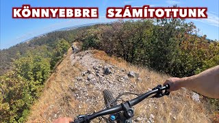
Popular Keleti-Bakony Mountain Biking Trails
• 100 ★ 0.0 • 2 miles • 31 ft • 11 •
Technical singletrail using footpaths and rutted sections carved by motorcycles going uphill. Trail head followed by a massive rock section then a flowy part with some narrow turns. As you reach a footpath, turn left and traverse to the...
• 95 ★ 5.0 • 2 miles • 3 ft • 10 •
Popular blue difficulty singletrack. This multi-use trail can be used downhill primary. It features rock face and rock garden. Trail visibility is sometimes hard to follow. On average it takes 15 minutes to complete this trail.
• 5 ★ 0.0 • 1,299 ft • 0 ft • 9 •
Less popular blue difficulty singletrack. This mountain bike primary trail can be used both directions and has a hard overall physical rating with a 0 ft black diamond climb. Trail visibility is always easy to follow. On average it takes 8 minutes to complete this trail.
• 85 ★ 5.0 • 2 miles • 0 ft • 8 •
Single trail next to Tési út. Upper half is forest with dirt surface and some medicore technical feature, bottom is a fast rocky track in a small canyon.
• 5 ★ 0.0 • 5,003 ft • 0 ft • 8 •
Less popular blue difficulty singletrack. This mountain bike primary trail can be used both directions. On average it takes 6 minutes to complete this trail.
• 80 ★ 0.0 • 2 miles • 0 ft • 7 •
Popular blue difficulty singletrack. This mountain bike primary trail can be used both directions.
• 65 ★ 0.0 • 2,149 ft • 3 ft • 5 •
Moderately popular blue difficulty singletrack. This mountain bike primary trail can be used both directions with a 3 ft blue climb. It features rock garden. Trail visibility is always easy to follow. On average it takes 1 minutes to complete this trail.
• 5 ★ 0.0 • 3,556 ft • 0 ft • 5 •
Less popular green difficulty singletrack. This mountain bike primary trail can be used both directions. Trail visibility is always easy to follow. On average it takes 3 minutes to complete this trail.
Photos of Keleti-Bakony Mountain Bike
Videos of Keleti-Bakony Mountain Bike


Recent Trail Reports
| status | trail | date | condition | info | user |
|---|---|---|---|---|---|
| Adidasz | Apr 10, 2026 @ 4:24pm (Europe/Budapest) Apr 10, 2026 | Ideal | hun-trails | ||
| Tési út melletti - single trail | Oct 23, 2021 @ 1:33am Oct 23, 2021 | Ideal | epenzes | ||
| Sötét-horog | Jul 10, 2021 @ 3:17am Jul 10, 2021 | Dry | epenzes | ||
| Katona - bottom part | Jul 7, 2021 @ 10:18am Jul 7, 2021 | Very Dry | gyenisp | ||
| Torii kapu - connector | Jul 7, 2021 @ 10:18am Jul 7, 2021 | Ideal | gyenisp | ||
| Katona | Jul 7, 2021 @ 10:18am Jul 7, 2021 | Very Dry | gyenisp | ||
| Gomba-hegy | Jul 7, 2021 @ 10:18am Jul 7, 2021 | Very Dry | gyenisp | ||
| Bunker | Jul 7, 2021 @ 10:18am Jul 7, 2021 | Ideal | gyenisp | ||
| SzenesHorog | Jul 7, 2021 @ 10:18am Jul 7, 2021 | Dry | gyenisp | ||
| Belátó | Jul 8, 2021 @ 9:29am Jul 8, 2021 | Very Dry | gyenisp |
Activity Feed
| username | action | type | title | date |
|---|---|---|---|---|
| tiszi77 | ridden | trail | activity #94729576 | May 14, 2026 @ 8:01pm May 14, 2026 |
| tiszi77 | vote | trail | activity #94729572 | May 14, 2026 @ 8:01pm May 14, 2026 |
| tiszi77 | ridden | trail | activity #94115633 | May 5, 2026 @ 2:45pm May 5, 2026 |
| hun-trails | add | report | activity #92318442 | Apr 10, 2026 @ 7:25am Apr 10, 2026 |
| AdamGrof | difficultyvote | trail | activity #90782801 | Mar 17, 2026 @ 11:31pm Mar 17, 2026 |
Nearby Areas
| name | distance | ||||
|---|---|---|---|---|---|
| Síaréna Bike Park | 1 | 8.3 km | |||
| Velencei-hegység | 7 | 6 | 20.4 km | ||
| Balaton-felvidék | 3 | 3 | 27.7 km | ||
| Gerecse | 7 | 9 | 2 | 35.4 km |
Local Badges
-

Completionist0 awarded
Activity Type Stats
| activitytype | trails | distance | descent | descent distance | total vertical | rating | global rank | state rank | photos | reports | routes | ridelogs |
|---|---|---|---|---|---|---|---|---|---|---|---|---|
| Mountain Bike | 27 | 25 miles | 6,594 ft | 17 miles | 1,345 ft | #1,814 | #9 | 82 | 35 | 342 | ||
| E-Bike | 9 | 12 miles | 2,493 ft | 6 miles | 1,115 ft | #1,251 | #10 | 27 | 8 | |||
| Horse | 2 | 3,517 ft | 95 ft | 1,844 ft | 102 ft | 6 | ||||||
| Hike | 27 | 25 miles | 6,594 ft | 17 miles | 1,345 ft | #1,501 | #8 | 35 | 13 | |||
| Trail Running | 27 | 25 miles | 6,594 ft | 17 miles | 1,345 ft | #884 | #8 | 35 | 5 |
Frequently Asked Questions About Keleti-Bakony
▼
What are the highest rated mountain biking trails in Keleti-Bakony?
The highest rated mountain biking trails in Keleti-Bakony are:
- Adidasz (4.1/5)
- Tési út melletti - single trail (4.1/5)
- Baglyas Enduro (4/5)
- SzenesHorog (3.8/5)
- Bér-hegy Enduro (0/5)
▼
Where can I park to ride in Keleti-Bakony?
Check the Keleti-Bakony trail map for trailhead and parking information. Community members regularly update access and parking details for trails in the area.
▼
What is the longest trail in Keleti-Bakony?
The longest trail in Keleti-Bakony is Tési út melletti - single trail at 2.0 miles. View all trails sorted by distance.
▼
What are the best & highest rated hiking trails in Keleti-Bakony?
The best hiking trails in Keleti-Bakony are: View all hiking trails sorted by popularity score.
Activities
- By gyenisp & contributors
- Admins: kaukerm, epenzes, kaukerm, epenzes
- #39416 - 2,313 views
- keleti-bakony activity log | embed map of Keleti-Bakony mountain bike trails |
Downloading of trail gps tracks in kml & gpx formats is enabled for Keleti-Bakony.
You must login to download files.