close
-
Layers w
- Weather Layers
- Pro
- Pro
- Pro
- Pro
- Pro
- Pro
- More Layers
- Pro
- Pro
- Pro
- Pro
-
Upgrade to

3D
Trail Conditions
- Unknown
- Snow Groomed
- Snow Packed
- Snow Covered
- Snow Cover Partial
- Freeze/thaw Cycle
- Icy
- Prevalent Mud
- Wet
- Variable
- Ideal
- Dry
- Very Dry
Trail Flow (Ridden Direction)
Trailforks scans users ridelogs to determine the most popular direction each trail is ridden. A good flowing trail network will have most trails flowing in a single direction according to their intension.
The colour categories are based on what percentage of riders are riding a trail in its intended direction.
The colour categories are based on what percentage of riders are riding a trail in its intended direction.
- > 96%
- > 90%
- > 80%
- > 70%
- > 50%
- < 50%
- bi-directional trail
- no data
Trail Last Ridden
Trailforks scans ridelogs to determine the last time a trail was ridden.
- < 2 days
- < 1 week
- < 2 weeks
- < 1 month
- < 6 months
- > 6 months
Trail Ridden Direction
The intended direction a trail should be ridden.
- Downhill Only
- Downhill Primary
- Both Directions
- Uphill Primary
- Uphill Only
- One Direction
Contribute Details
Colors indicate trail is missing specified detail.
- Description
- Photos
- Description & Photos
- Videos
Trail Popularity ?
Trailforks scans ridelogs to determine which trails are ridden the most in the last 9 months.
Trails are compared with nearby trails in the same city region with a possible 25 colour shades.
Think of this as a heatmap, more rides = more kinetic energy = warmer colors.
- most popular
- popular
- less popular
- not popular
ATV/ORV/OHV Filter
Max Vehicle Width
inches
US Cell Coverage
Legend

Radar Time
Activity Recordings
Trailforks uses anonymized public activity data.
?
Activity Recordings
Trailforks uses anonymized public activity data.
?
Personal Heatmap
▶
Activity Types
all
/
none
▶
Options
2
Date range
month
–
Winter Trails
Warning
A routing network for winter maps does not exist. Selecting trails using the winter trails layer has been disabled.
Missing Trails
Most Popular
Least Popular
Trails are colored based on popularity. The more popular a trail is, the more red. Less popular trails trend towards green.
Jump Magnitude Heatmap
Heatmap of where riders jump on trails. Zoom in to see individual jumps, click circles to view jump details.
BC Backroad Status
![map legend]()
Service Road Atlas is a free to use, community-driven service for viewing and creating reports on the numerous back-country service roads around B.C. and Alberta.

Slope Aspect
Direction the slope faces
Trails Deemphasized
Trails are shown in grey.
Only show trails with no bike usage.
Suggested Layers
Based on selected activity type
Save the current map location and zoom level as your default home location whenever this page is loaded.
Save
No description for Kendal has been added yet!
Login or register to submit one.
This region uses the Uk/Euro style trail grading system.
Activities Click to view
- Mountain Bike
14 trails
- E-Bike
6 trails
- Gravel Bike
0 trails
- Adaptive Bike
0 trails
- Winter Fat Bike
0 trails
- Hike
26 trails
- Trail Running
26 trails
Region Details
- 2
- 2
- 6
- 3
Region Status
Caution as of Jun 13, 2026Stats
- Avg Trail Rating
- Trails (view details)
- 26
- Trails Mountain Bike
- 14
- Trails E-Bike
- 6
- Trails Horse
- 1
- Trails Hike
- 26
- Trails Trail Running
- 26
- Total Distance
- 21 miles
- Total Descent
- 4,474 ft
- Total Vertical
- 672 ft
- Highest Trailhead
- 834 ft
- Reports
- 37
- Photos
- 12
- Ridden Counter
- 956
Sub Regions
-
Farleton
- 2
- 3
Popular Kendal Mountain Biking Trails
• 90 ★ 0.0 • 3,963 ft • 57 ft • 43 •
Popular green difficulty mixed. This mountain bike primary trail can be used both directions. On average it takes 7 minutes to complete this trail.
• 100 ★ 0.0 • 3,448 ft • 12 ft • 39 •
Popular blue difficulty singletrack. This mountain bike primary trail can be used both directions. On average it takes 5 minutes to complete this trail.
• 5 ★ 0.0 • 1,643 ft • 0 ft • 37 •
One of the more busy trails on Farleton. Take care when riding down as mult use
• 95 ★ 0.0 • 1 mile • 96 ft • 35 •
Popular blue difficulty mixed. This mountain bike primary trail can be used both directions. On average it takes 10 minutes to complete this trail.
• 5 ★ 0.0 • 2,949 ft • 145 ft • 28 •
Optional left line for a severe trail, however, right route takes you on a less steep and more manageable trail.
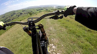
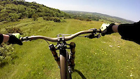
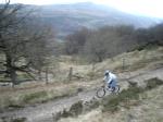
Photos of Kendal Mountain Bike
Videos of Kendal Mountain Bike
trail: F.O.F
2:09 |
213 |
Jun 18, 2017
trail: NAMBS DH
2:20 |
525 |
Jun 18, 2017
trail: Titty Twister
0:22 |
346 |
Jan 4, 2009
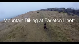
trail: NAMBS DH
5:25 |
816 |
Jan 31, 2020 , Kendal
Recent Trail Reports
| status | trail | date | condition | info | user |
|---|---|---|---|---|---|
| Hart Howe descent | Jun 13, 2026 @ 8:28am (Europe/London) Jun 13, 2026 | Ideal | whyte120 | ||
| Crook Hall Farm bypass | Jun 13, 2026 @ 8:28am (Europe/London) Jun 13, 2026 | Ideal | whyte120 | ||
| NAMBS DH | Dec 26, 2025 @ 12:13pm (Europe/London) Dec 26, 2025 | Variable | SolArmer | ||
| Steep n rocky | Dec 26, 2025 @ 12:06pm (Europe/London) Dec 26, 2025 | Prevalent Mud | SolArmer | ||
| Gamblesmire Lane | Apr 13, 2025 @ 10:40am Apr 13, 2025 | Ideal | Heywood165 | ||
| Pig Track | Apr 23, 2024 @ 10:35am Apr 23, 2024 | Ideal | steve-jennings | ||
| Yewbarrow | Jan 4, 2024 @ 6:20am Jan 4, 2024 | Prevalent Mud | whyte120 | ||
| Titty Twister | Sep 4, 2020 @ 9:38am Sep 4, 2020 | Dry | AdamFox | ||
| SERPINTINE DOWNHILL | Aug 3, 2020 @ 4:34am Aug 3, 2020 | Prevalent Mud | Lucas1211 | ||
| Access Route | Jan 7, 2018 @ 7:09am Jan 7, 2018 | Icy | Jatkinson727 |
Activity Feed
| username | action | type | title | date |
|---|---|---|---|---|
| whyte120 | add | report | activity #96952722 and 1 more | Jun 14, 2026 @ 4:01am Jun 14, 2026 |
| Gorilla-Brakes | add | photo | activity #96611684 | Jun 9, 2026 @ 9:37am Jun 9, 2026 |
| SolArmer | ridden | trail | activity #86082042 | Dec 26, 2025 @ 6:07am Dec 26, 2025 |
| SolArmer | vote | trail | activity #86082039 | Dec 26, 2025 @ 6:07am Dec 26, 2025 |
| SolArmer | add | report | activity #86076604 and 1 more | Dec 26, 2025 @ 4:06am Dec 26, 2025 |
Recent Comments
| username | type | title | comment | date |
|---|---|---|---|---|
| trail | Does anyone know if this still exists | Sep 3, 2021 @ 8:40am Sep 3, 2021 | ||
| trail | Not many natural Jumps, we are still building... | Dec 19, 2020 @ 3:34pm Dec 19, 2020 | ||
| trail | Great trail, many variety’s of jumps | Mar 24, 2020 @ 9:13am Mar 24, 2020 |
Local Badges
-

Epic Ride Climb 2k33 awarded -

Climbing 10k Badge31 awarded -

Climbing 100k Badge2 awarded -

Epic Ride Descent 2k31 awarded -

Descent 10k Badge31 awarded -

Descent 100k Badge2 awarded
Activity Type Stats
| activitytype | trails | distance | descent | descent distance | total vertical | rating | global rank | state rank | photos | reports | routes | ridelogs |
|---|---|---|---|---|---|---|---|---|---|---|---|---|
| Mountain Bike | 14 | 9 miles | 2,398 ft | 5 miles | 659 ft | #5,440 | #191 | 12 | 37 | 5,531 | ||
| E-Bike | 6 | 2 miles | 1,093 ft | 2 miles | 535 ft | #5,928 | #261 | 24 | 346 | |||
| Horse | 1 | 1 mile | 3 ft | 295 ft | 433 ft | 6 | ||||||
| Hike | 26 | 21 miles | 4,475 ft | 12 miles | 673 ft | #5,971 | #145 | 36 | 494 | |||
| Trail Running | 26 | 21 miles | 4,475 ft | 12 miles | 673 ft | #5,542 | #137 | 36 | 837 |
Frequently Asked Questions About Kendal
▼
What are the best places to ride in Kendal?
Kendal has 1 areas to explore for mountain biking. The top rated areas are:
▼
What are the highest rated mountain biking trails in Kendal?
The highest rated mountain biking trails in Kendal are:
- SERPINTINE DOWNHILL (4.1/5)
- Pig Track (4/5)
- Titty Twister (4/5)
- Kendal Valley sprint (3.8/5)
- NAMBS DH (3.8/5)
▼
What is the best time of the year to ride in Kendal?
Based on ride log data, the most popular months to ride in Kendal are:
- July (18 activities)
- April (17 activities)
- August (14 activities)
▼
Where can I park to ride in Kendal?
Check the Kendal trail map for trailhead and parking information. Community members regularly update access and parking details for trails in the area.
Activities
Trails
Points of Interest
- By gav-s
 & contributors
 - Admins: wisey, MathieuC, cemoorelife
- #20958 - 6,610 views
- kendal activity log | embed map of Kendal mountain bike trails |
Downloading of trail gps tracks in kml & gpx formats is enabled for Kendal.
You must login to download files.