close
-
Layers w
- Weather Layers
- Pro
- Pro
- Pro
- Pro
- Pro
- Pro
- More Layers
- Pro
- Pro
- Pro
- Pro
-
Upgrade to

3D
Trail Conditions
- Unknown
- Snow Groomed
- Snow Packed
- Snow Covered
- Snow Cover Partial
- Freeze/thaw Cycle
- Icy
- Prevalent Mud
- Wet
- Variable
- Ideal
- Dry
- Very Dry
Trail Flow (Ridden Direction)
Trailforks scans users ridelogs to determine the most popular direction each trail is ridden. A good flowing trail network will have most trails flowing in a single direction according to their intension.
The colour categories are based on what percentage of riders are riding a trail in its intended direction.
The colour categories are based on what percentage of riders are riding a trail in its intended direction.
- > 96%
- > 90%
- > 80%
- > 70%
- > 50%
- < 50%
- bi-directional trail
- no data
Trail Last Ridden
Trailforks scans ridelogs to determine the last time a trail was ridden.
- < 2 days
- < 1 week
- < 2 weeks
- < 1 month
- < 6 months
- > 6 months
Trail Ridden Direction
The intended direction a trail should be ridden.
- Downhill Only
- Downhill Primary
- Both Directions
- Uphill Primary
- Uphill Only
- One Direction
Contribute Details
Colors indicate trail is missing specified detail.
- Description
- Photos
- Description & Photos
- Videos
Trail Popularity ?
Trailforks scans ridelogs to determine which trails are ridden the most in the last 9 months.
Trails are compared with nearby trails in the same city region with a possible 25 colour shades.
Think of this as a heatmap, more rides = more kinetic energy = warmer colors.
- most popular
- popular
- less popular
- not popular
ATV/ORV/OHV Filter
Max Vehicle Width
inches
US Cell Coverage
Legend

Radar Time
Activity Recordings
Trailforks uses anonymized public activity data.
?
Activity Recordings
Trailforks uses anonymized public activity data.
?
Personal Heatmap
▶
Activity Types
all
/
none
▶
Options
2
Date range
month
–
Winter Trails
Warning
A routing network for winter maps does not exist. Selecting trails using the winter trails layer has been disabled.
Missing Trails
Most Popular
Least Popular
Trails are colored based on popularity. The more popular a trail is, the more red. Less popular trails trend towards green.
Jump Magnitude Heatmap
Heatmap of where riders jump on trails. Zoom in to see individual jumps, click circles to view jump details.
BC Backroad Status
![map legend]()
Service Road Atlas is a free to use, community-driven service for viewing and creating reports on the numerous back-country service roads around B.C. and Alberta.

Slope Aspect
Direction the slope faces
Trails Deemphasized
Trails are shown in grey.
Only show trails with no bike usage.
Suggested Layers
Based on selected activity type
Save the current map location and zoom level as your default home location whenever this page is loaded.
SaveA cross-country trail system that is an advanced, technical trail system to ride. The trail doesn't follow the concours and is a heavy dose of climbing and straight shot descents that are challenging to ride. Bring a patch kit, as there is a lot of glass in the tread surface, which is known to slash sidewalls. Stay aware of your surroundings and enjoy your time in riding thru some of the older sections of forest in KC.
Primary Trail Type: Cross-Country
eBikes Allowed:
Yes
AKA: Cliff Drive
Land Status: City Managed
 google parking directions
 Access Info:
For on-street parking, take Paseo north from the intersection of Paseo and Independence Avenue, to the Cliff Drive Gate. This gate is closed to car traffic. Parking can also be found in the adjacent neighborhoods just ensure all valubles and doors are locked up and hidden from view.
Links
Activities Click to view
- Mountain Bike
28 trails
- E-Bike
13 trails
- Hike
27 trails
- Trail Running
27 trails
Region Details
- 3
- 1
- 12
- 1
Region Status
Open as of May 8, 2026Local Trail Association
Stats
- Avg Trail Rating
- Trails (view details)
- 17
- Trails Mountain Bike
- 29
- Trails E-Bike
- 13
- Trails Hike
- 27
- Trails Trail Running
- 27
- Total Distance
- 8 miles
- Total Descent
- 1,103 ft
- Total Vertical
- 227 ft
- Highest Trailhead
- 992 ft
- Reports
- 254
- Photos
- 13
- Ridden Counter
- 1,008
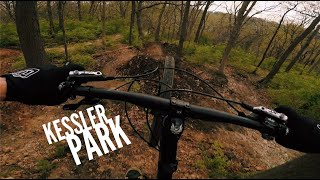
Popular Kessler Park Mountain Biking Trails
• 85 ★ 0.0 • 998 ft • 2 ft • 107 •
Popular blue difficulty singletrack. This mountain bike primary trail can be used both directions. On average it takes 1 minutes to complete this trail.
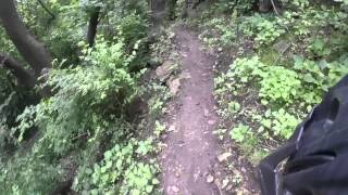
• 80 ★ 0.0 • 1 mile • 117 ft • 97 •
This is the section of the Kessler Park Singletrack. It is mostly fast and flowy with a lot of up and down. There are a few jumps and pumpers along the way. Going west you will get some speed and feel like you're in The Return of the...
• 75 ★ 0.0 • 2,100 ft • 24 ft • 92 •
Popular blue difficulty singletrack. This mountain bike primary trail and has a moderate overall physical rating with a 24 ft blue climb. Trail visibility is always easy to follow. On average it takes 2 minutes to complete this trail.
• 45 ★ 0.0 • 1,781 ft • 82 ft • 86 •
Moderately popular white difficulty family friendly singletrack. This mountain bike primary trail can be used both directions. On average it takes 1 minutes to complete this trail.
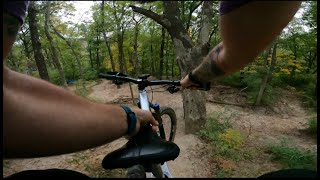
• 40 ★ 5.0 • 1 mile • 114 ft • 76 •
This is an old boy scout trail that has been reclaimed. It is fast and fun with lots of up and down. There are great views as well. You're right up next to the cliff/bluff but never really dangerously close. There are some steep climbs...
• 50 ★ 0.0 • 3,474 ft • 83 ft • 72 •
Moderately popular blue difficulty singletrack. This mountain bike primary trail and has a moderate overall physical rating with a 83 ft blue climb. Trail visibility is always easy to follow. On average it takes 7 minutes to complete this trail.
• 60 ★ 0.0 • 3,901 ft • 171 ft • 70 •
Moderately popular white difficulty paved path. This multi-use trail can be used both directions. On average it takes 3 minutes to complete this trail.
• 45 ★ 0.0 • 1,870 ft • 65 ft • 53 •
Moderately popular blue difficulty singletrack. This mountain bike primary trail. On average it takes 4 minutes to complete this trail.
Videos of Kessler Park Mountain Bike
trail: Wright Way
3:03 |
68 |
Jan 23, 2026 , Kansas City, MO

trail: Wright Way
3:24 |
72 |
Jan 23, 2026 , Kansas City, MO
trail: Lozier's Lane
3:10 |
22 |
Jan 23, 2026 , Kansas City, MO
7:09 |
48 |
Nov 3, 2025
youtuber
![KESSLER PARK | KANSAS CITY, MISSOURI]()

753 |
Jul 28, 2017
Recent Trail Reports
| status | trail | date | condition | info | user |
|---|---|---|---|---|---|
| Racecar | Apr 11, 2026 @ 10:45am (America/Indiana/Vincennes) Apr 11, 2026 | Ideal | Rockyroads33 | ||
| Wright Way | Feb 20, 2026 @ 8:17am (America/Chicago) Feb 20, 2026 | Ideal | GuillermoJoseHernandez | ||
| Wilderness Extension | Feb 20, 2026 @ 8:17am (America/Chicago) Feb 20, 2026 | Ideal | GuillermoJoseHernandez | ||
| Wilderness Connector | Feb 20, 2026 @ 8:17am (America/Chicago) Feb 20, 2026 | Ideal | GuillermoJoseHernandez | ||
| The Wilderness | Feb 20, 2026 @ 8:17am (America/Chicago) Feb 20, 2026 | Ideal | GuillermoJoseHernandez | ||
| Scarritt Forest | Feb 20, 2026 @ 8:17am (America/Chicago) Feb 20, 2026 | Ideal | GuillermoJoseHernandez | ||
| Lozier's Lane | Feb 20, 2026 @ 8:17am (America/Chicago) Feb 20, 2026 | Ideal | GuillermoJoseHernandez | ||
| Indian Mound Return | Feb 20, 2026 @ 8:17am (America/Chicago) Feb 20, 2026 | Ideal | GuillermoJoseHernandez | ||
| Indian Mound | Feb 20, 2026 @ 8:17am (America/Chicago) Feb 20, 2026 | Ideal | GuillermoJoseHernandez | ||
| Gooseneck | Feb 20, 2026 @ 8:17am (America/Chicago) Feb 20, 2026 | Ideal | GuillermoJoseHernandez |
Activity Feed
| username | action | type | title | date |
|---|---|---|---|---|
| GuillermoJoseHernandez | update | region | activity #92657078 | Apr 15, 2026 @ 6:53am Apr 15, 2026 |
| Rockyroads33 | add | report | activity #92410730 | Apr 11, 2026 @ 11:03am Apr 11, 2026 |
| GuillermoJoseHernandez | add | report | activity #89220809 and 13 more | Feb 20, 2026 @ 6:17am Feb 20, 2026 |
| GuillermoJoseHernandez | add | video | activity #87690191 and 2 more | Jan 23, 2026 @ 1:28pm Jan 23, 2026 |
| GuillermoJoseHernandez | add | poi | activity #83635024 and 2 more | Nov 5, 2025 @ 12:50pm Nov 5, 2025 |
Nearby Areas
| name | distance | ||||
|---|---|---|---|---|---|
| Macken Park (William E. Macken City Park) | 3 km | ||||
| Hidden Valley Park | 2 | 2 | 3.3 km | ||
| Rozarks | 1 | 6 | 1 | 6.1 km | |
| Maple Woods Conservation Aera | 1 | 7.8 km | |||
| Nall Park | 2 | 1 | 8.1 km |
Activity Type Stats
| activitytype | trails | distance | descent | descent distance | total vertical | rating | global rank | state rank | photos | reports | routes | ridelogs |
|---|---|---|---|---|---|---|---|---|---|---|---|---|
| Mountain Bike | 28 | 8 miles | 1,102 ft | 3 miles | 226 ft | #12,981 | #5,272 | 12 | 254 | 1,921 | ||
| E-Bike | 13 | #9,278 | #3,063 | 249 | 78 | |||||||
| Hike | 27 | 8 miles | 1,033 ft | 3 miles | 226 ft | 254 | 26 | |||||
| Trail Running | 27 | 8 miles | 1,033 ft | 3 miles | 226 ft | #11,239 | #4,328 | 1 | 254 | 25 |
Frequently Asked Questions About Kessler Park
▼
What are the highest rated mountain biking trails in Kessler Park?
The highest rated mountain biking trails in Kessler Park are:
- Indian Mound (4.1/5)
- Gooseneck (0/5)
- Scarritt Forest (0/5)
- Gladstone Asphalt Path West (0/5)
- Cliff Drive (0/5)
▼
What is the best time of the year to ride in Kessler Park?
Based on ride log data, the most popular months to ride in Kessler Park are:
- August (10 activities)
- October (7 activities)
- July (6 activities)
▼
Where can I park to ride in Kessler Park?
▼
What is the longest trail in Kessler Park?
The longest trail in Kessler Park is Scarritt Forest at 1.4 miles. View all trails sorted by distance.
Activities
- By d-urb & contributors
- Admins: UTC Central
- #6486 - 8,959 views
- kessler park activity log | embed map of Kessler Park mountain bike trails | kessler park mountain biking points of interest
Downloading of trail gps tracks in kml & gpx formats is enabled for Kessler Park.
You must login to download files.