close
-
Layers w
- Weather Layers
- Pro
- Pro
- Pro
- Pro
- Pro
- Pro
- More Layers
- Pro
- Pro
- Pro
- Pro
-
Upgrade to

3D
Trail Conditions
- Unknown
- Snow Groomed
- Snow Packed
- Snow Covered
- Snow Cover Partial
- Freeze/thaw Cycle
- Icy
- Prevalent Mud
- Wet
- Variable
- Ideal
- Dry
- Very Dry
Trail Flow (Ridden Direction)
Trailforks scans users ridelogs to determine the most popular direction each trail is ridden. A good flowing trail network will have most trails flowing in a single direction according to their intension.
The colour categories are based on what percentage of riders are riding a trail in its intended direction.
The colour categories are based on what percentage of riders are riding a trail in its intended direction.
- > 96%
- > 90%
- > 80%
- > 70%
- > 50%
- < 50%
- bi-directional trail
- no data
Trail Last Ridden
Trailforks scans ridelogs to determine the last time a trail was ridden.
- < 2 days
- < 1 week
- < 2 weeks
- < 1 month
- < 6 months
- > 6 months
Trail Ridden Direction
The intended direction a trail should be ridden.
- Downhill Only
- Downhill Primary
- Both Directions
- Uphill Primary
- Uphill Only
- One Direction
Contribute Details
Colors indicate trail is missing specified detail.
- Description
- Photos
- Description & Photos
- Videos
Trail Popularity ?
Trailforks scans ridelogs to determine which trails are ridden the most in the last 9 months.
Trails are compared with nearby trails in the same city region with a possible 25 colour shades.
Think of this as a heatmap, more rides = more kinetic energy = warmer colors.
- most popular
- popular
- less popular
- not popular
ATV/ORV/OHV Filter
Max Vehicle Width
inches
US Cell Coverage
Legend

Radar Time
Activity Recordings
Trailforks uses anonymized public activity data.
?
Activity Recordings
Trailforks uses anonymized public activity data.
?
Personal Heatmap
▶
Activity Types
all
/
none
▶
Options
2
Date range
month
–
Winter Trails
Warning
A routing network for winter maps does not exist. Selecting trails using the winter trails layer has been disabled.
Missing Trails
Most Popular
Least Popular
Trails are colored based on popularity. The more popular a trail is, the more red. Less popular trails trend towards green.
Jump Magnitude Heatmap
Heatmap of where riders jump on trails. Zoom in to see individual jumps, click circles to view jump details.
BC Backroad Status
![map legend]()
Service Road Atlas is a free to use, community-driven service for viewing and creating reports on the numerous back-country service roads around B.C. and Alberta.

Slope Aspect
Direction the slope faces
Trails Deemphasized
Trails are shown in grey.
Only show trails with no bike usage.
Suggested Layers
Based on selected activity type
Save the current map location and zoom level as your default home location whenever this page is loaded.
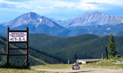
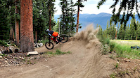
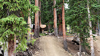
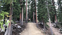
SaveThe Keystone Bike Park consists of some of the country's best downhill trails with progressive terrain for riders of all abilities. Take your bike up a chairlift and gain access to some of Colorado’s most exhilarating expert downhill challenges with rock gardens, rock drops and high-speed features. Beginner and intermediate bikers can enjoy roller coaster rides over bridges and berms without the steepness or rock gardens you’ll find in other areas of the park.
And, Keystone is the hub for hundreds of miles of world-class single track . The Keystone Bike Park trails combined with the trails branching from the Colorado Trail provide seemingly endless riding opportunities.
View region descriptions for other activity types
And, Keystone is the hub for hundreds of miles of world-class single track . The Keystone Bike Park trails combined with the trails branching from the Colorado Trail provide seemingly endless riding opportunities.
source: Keystone Resort
Generic
Mountain Bike
The Keystone Bike Park consists of some of the country's best downhill trails with progressive terrain for riders of all abilities. Take your bike up a chairlift and gain access to some of Colorado’s most exhilarating expert downhill challenges with rock gardens, rock drops and high-speed features. Beginner and intermediate bikers can enjoy roller coaster rides over bridges and berms without the steepness or rock gardens you’ll find in other areas of the park.And, Keystone is the hub for hundreds of miles of world-class single track . The Keystone Bike Park trails combined with the trails branching from the Colorado Trail provide seemingly endless riding opportunities.
Downhill Ski
Keystone Resort is a mountain playground built for nonstop adventure and unforgettable moments. Set in Colorado’s high alpine terrain, Keystone offers expansive skiing and riding across three distinct peaks, perfectly groomed runs, and one of the longest ski days in the Rockies with legendary night skiing. From wide-open bowls and tree-lined trails to family-friendly villages, lakeside dining, and year-round activities, Keystone blends high-energy fun with relaxed mountain charm. Whether you’re carving first turns, chasing fresh powder, or making memories off the slopes, Keystone delivers a vibrant, all-in mountain experience from first chair to last light.Primary Trail Type: All-Mountain & Downhill
eBikes Allowed:
Yes
AKA: Keystone Bike Park
Land Status: Ski Resort
 google parking directions
 Activities Click to view
- Mountain Bike
36 trails
- E-Bike
38 trails
- Hike
7 trails
- Trail Running
3 trails
- Downhill Ski
148 trails
Region Details
- 4
- 11
- 5
- 9
- 7
Region Status
Closed as of Apr 6, 2026- Day Ticket
- $74 USD
- Uplift Type
- Chair Lift
Stats
- Avg Trail Rating
- Trails (view details)
- 177
- Trails Mountain Bike
- 36
- Trails E-Bike
- 38
- Trails Hike
- 7
- Trails Trail Running
- 3
- Trails Downhill Ski
- 150
- Total Distance
- 99 miles
- Total Descent
- 79,886 ft
- Total Vertical
- 3,008 ft
- Highest Trailhead
- 12,291 ft
- Reports
- 1,094
- Photos
- 268
- Ridden Counter
- 33,931
Articles
Race Report: Catanzarite & Kelley win Revolution Enduro Round 4 at Keystone
Aug 7, 2025 from pinkbike.com
Two days of excellent racing on the notoriously rough, rugged and long trails at the Keystone bike park.
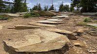
Popular Keystone Resort Mountain Biking Trails
• 15 ★ 0.0 • 1,585 ft • 0 ft • 5 •
Less popular green difficulty ski run (piste). This multi-use trail can be used downhill only.
Keystone Resort Mountain Bike Routes
5 miles • 508 ft • 2 •
1 mile • 1 • Point to Point •
2025 Keystone Rev Enduro (Day 2) Featured
★ 5.0 • 10 miles • 2,319 ft • 7 • Race •
2025 Keystone Rev Enduro Day 2 Day 2: Transfer: to Stage 4 Stage 4 FINISH Transfer: Downhill to Stage 5...
2024 Keystone Rev Enduro (Day 2) Featured
★ 5.0 • 7 miles • 1,048 ft • 6 • Race •
2024 Keystone Rev Enduro Day 2 Day 2: Transfer: to Stage 4 Stage 4 FINISH Transfer: Pedal Up Jackstraw to...
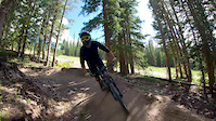
Photos of Keystone Resort Mountain Bike
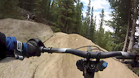
Videos of Keystone Resort Mountain Bike
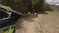
trail: Paid-in-Full
0:17 |
134 |
Jul 25, 2022
trail: High Speed Dirt
0:12 |
235 |
Jul 4, 2022
trail: Cowboy Up
0:12 |
136 |
Jul 9, 2020
trail: Cowboy Up
0:36 |
460 |
May 26, 2020
trail: Cowboy Up
0:36 |
|
May 26, 2020
trail: Cowboy Up
0:31 |
108 |
Aug 18, 2019
trail: Jam Rock
0:58 |
336 |
Jan 12, 2017
trail: TNT
0:00 |
282 |
Sep 1, 2016
Recent Trail Reports
| status | trail | date | condition | info | user |
|---|---|---|---|---|---|
| Summit Express Quad | Feb 10, 2026 @ 10:54am (America/Denver) Feb 10, 2026 | Unknown | markholloway Trailforks | ||
| Ina's Way | Feb 10, 2026 @ 10:53am (America/Denver) Feb 10, 2026 | Unknown | markholloway Trailforks | ||
| Wild Thing | Nov 8, 2025 @ 11:41am (America/Denver) Nov 8, 2025 | Snow Covered | J4m3z420 SCoMBA | ||
| Suz’s Cruise | Nov 8, 2025 @ 11:41am (America/Denver) Nov 8, 2025 | Snow Covered | J4m3z420 SCoMBA | ||
| Sleepy Hollow | Nov 8, 2025 @ 11:41am (America/Denver) Nov 8, 2025 | Snow Covered | J4m3z420 SCoMBA | ||
| Sanitarium | Nov 8, 2025 @ 11:41am (America/Denver) Nov 8, 2025 | Snow Covered | J4m3z420 SCoMBA | ||
| River Run Trail | Nov 8, 2025 @ 11:41am (America/Denver) Nov 8, 2025 | Snow Covered | J4m3z420 SCoMBA | ||
| Ride On | Nov 8, 2025 @ 11:41am (America/Denver) Nov 8, 2025 | Snow Covered | J4m3z420 SCoMBA | ||
| Punk Rock | Nov 8, 2025 @ 11:41am (America/Denver) Nov 8, 2025 | Snow Covered | J4m3z420 SCoMBA | ||
| Paid-in-Full | Nov 8, 2025 @ 11:41am (America/Denver) Nov 8, 2025 | Snow Covered | J4m3z420 SCoMBA |
Activity Feed
| username | action | type | title | date |
|---|---|---|---|---|
| yDUNIf | wishlist | trail | activity #91042649 | Mar 21, 2026 @ 6:59pm Mar 21, 2026 |
| Zanethefargonian | wishlist | trail | activity #90899743 | Mar 19, 2026 @ 9:02pm Mar 19, 2026 |
| rwalkz | wishlist | trail | activity #89940542 | Mar 4, 2026 @ 2:36am Mar 4, 2026 |
| markholloway | add | report | activity #88682018 and 164 more | Feb 10, 2026 @ 9:53am Feb 10, 2026 |
| markholloway | update | region | activity #88679945 | Feb 10, 2026 @ 9:10am Feb 10, 2026 |
Recent Comments
| username | type | title | comment | date |
|---|---|---|---|---|
| trail | Trail is very funny and physically demanding... | Jun 27, 2025 @ 9:07pm Jun 27, 2025 | ||
| trail | Steep but very funny trail | Jun 27, 2025 @ 9:05pm Jun 27, 2025 | ||
| trail | not a double black, hard blue easy black at... | Jun 22, 2025 @ 3:21pm Jun 22, 2025 | ||
| trail | Re: last comment is ridiculous, I did this on... | Aug 31, 2024 @ 10:51am Aug 31, 2024 | ||
| trail | Keystone rebuilt this trail in 2022(?) Changed... | Aug 21, 2024 @ 6:00pm Aug 21, 2024 |
Nearby Areas
| name | distance | ||||
|---|---|---|---|---|---|
| Summit Cove | 9 | 9 | 2.8 km | ||
| Tenderfoot Mountain Area | 2 | 15 | 3.2 km | ||
| Arapahoe Basin | 4 | 1 | 5.1 km | ||
| Frisco Peninsula | 12 | 19 | 4 | 1 | 6.2 km |
| Jones Pass | 1 | 4 | 11.8 km |
Local Badges
-

Completionist0 awarded
Local Mountain Biking Directory
-
Norski SportsBike Shop
Activity Type Stats
| activitytype | trails | distance | descent | descent distance | total vertical | rating | global rank | state rank | photos | reports | routes | ridelogs |
|---|---|---|---|---|---|---|---|---|---|---|---|---|
| Mountain Bike | 36 | 28 miles | 9,610 ft | 17 miles | 2,362 ft | #1,055 | #375 | 268 | 1,077 | 9 | 5,206 | |
| E-Bike | 38 | 30 miles | 9,961 ft | 18 miles | 2,487 ft | #2,925 | #910 | 495 | 99 | |||
| Hike | 7 | 2 miles | 351 ft | 1 mile | 236 ft | #12,396 | #5,142 | 1,043 | 1 | 115 | ||
| Trail Running | 3 | 2 miles | 351 ft | 1 mile | 236 ft | #13,465 | #5,610 | 1,043 | 1 | 28 | ||
| Downhill Ski | 148 | 68 miles | 69,925 ft | 65 miles | 2,949 ft | #55 | #34 | 710 | 3,958 |
Frequently Asked Questions About Keystone Resort
▼
What are the highest rated mountain biking trails in Keystone Resort?
The highest rated mountain biking trails in Keystone Resort are:
- Jam Rock (4.6/5)
- Paid-in-Full (4.5/5)
- Eye of the Tiger (4.4/5)
- Cowboy Up (4.3/5)
- High Speed Dirt (4.3/5)
▼
What is the best time of the year to ride in Keystone Resort?
Based on ride log data, the most popular months to ride in Keystone Resort are:
- July (95 activities)
- August (81 activities)
- June (29 activities)
▼
Where can I park to ride in Keystone Resort?
There are 3 parking locations listed in Keystone Resort. The most popular parking spots are: View all parking and trailhead locations on the map to plan your visit.
▼
What is the longest trail in Keystone Resort?
The longest trail in Keystone Resort is Let it Ride at 4.6 km. View all trails sorted by distance.
Activities
Trails
- By brenthillier
 NSMBA TRAILFORKS & contributors
 - Admins: VAIL, SCoMBA
- #4173 - 21,725 views
- keystone resort activity log | embed map of Keystone Resort mountain bike trails | keystone resort mountain biking points of interest
Downloading of trail gps tracks in kml & gpx formats is enabled for Keystone Resort.
You must login to download files.