close
-
Layers w
- Weather Layers
- Pro
- Pro
- Pro
- Pro
- Pro
- Pro
- More Layers
- Pro
- Pro
- Pro
- Pro
-
Upgrade to

3D
Trail Conditions
- Unknown
- Snow Groomed
- Snow Packed
- Snow Covered
- Snow Cover Partial
- Freeze/thaw Cycle
- Icy
- Prevalent Mud
- Wet
- Variable
- Ideal
- Dry
- Very Dry
Trail Flow (Ridden Direction)
Trailforks scans users ridelogs to determine the most popular direction each trail is ridden. A good flowing trail network will have most trails flowing in a single direction according to their intension.
The colour categories are based on what percentage of riders are riding a trail in its intended direction.
The colour categories are based on what percentage of riders are riding a trail in its intended direction.
- > 96%
- > 90%
- > 80%
- > 70%
- > 50%
- < 50%
- bi-directional trail
- no data
Trail Last Ridden
Trailforks scans ridelogs to determine the last time a trail was ridden.
- < 2 days
- < 1 week
- < 2 weeks
- < 1 month
- < 6 months
- > 6 months
Trail Ridden Direction
The intended direction a trail should be ridden.
- Downhill Only
- Downhill Primary
- Both Directions
- Uphill Primary
- Uphill Only
- One Direction
Contribute Details
Colors indicate trail is missing specified detail.
- Description
- Photos
- Description & Photos
- Videos
Trail Popularity ?
Trailforks scans ridelogs to determine which trails are ridden the most in the last 9 months.
Trails are compared with nearby trails in the same city region with a possible 25 colour shades.
Think of this as a heatmap, more rides = more kinetic energy = warmer colors.
- most popular
- popular
- less popular
- not popular
ATV/ORV/OHV Filter
Max Vehicle Width
inches
US Cell Coverage
Legend

Radar Time
Activity Recordings
Trailforks uses anonymized public activity data.
?
Activity Recordings
Trailforks uses anonymized public activity data.
?
Personal Heatmap
▶
Activity Types
all
/
none
▶
Options
2
Date range
month
–
Winter Trails
Warning
A routing network for winter maps does not exist. Selecting trails using the winter trails layer has been disabled.
Missing Trails
Most Popular
Least Popular
Trails are colored based on popularity. The more popular a trail is, the more red. Less popular trails trend towards green.
Jump Magnitude Heatmap
Heatmap of where riders jump on trails. Zoom in to see individual jumps, click circles to view jump details.
BC Backroad Status
![map legend]()
Service Road Atlas is a free to use, community-driven service for viewing and creating reports on the numerous back-country service roads around B.C. and Alberta.

Slope Aspect
Direction the slope faces
Trails Deemphasized
Trails are shown in grey.
Only show trails with no bike usage.
Suggested Layers
Based on selected activity type
Save the current map location and zoom level as your default home location whenever this page is loaded.
Save
No description for Kiama has been added yet!
Login or register to submit one.
Activities Click to view
- Mountain Bike
3 trails
- E-Bike
3 trails
- Adaptive Bike
0 trails
- Hike
3 trails
- Trail Running
3 trails
Region Details
- 3
Region Status
Open as of Mar 18, 2026Stats
- Avg Trail Rating
- Trails (view details)
- 3
- Trails Mountain Bike
- 3
- Trails E-Bike
- 3
- Trails Hike
- 3
- Trails Trail Running
- 3
- Total Distance
- 8 miles
- Total Descent Distance
- 4 miles
- Total Descent
- 749 ft
- Total Vertical
- 144 ft
- Highest Trailhead
- 149 ft
- Reports
- 23
- Photos
- 14
- Ridden Counter
- 283
Sub Regions
-
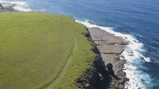
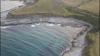
Kiama Coastline Trails
- 3
Popular Kiama Mountain Biking Trails
• 100 ★ 4.8 • 3 miles • 389 ft • 102 •
The most picturesque and unsealed section of the Costal track (22km including pathways). Incredible views all the way riding along the coast and cliff edge. Some very step climbing along the track, is generally mown but can stay damp...
• 50 ★ 0.0 • 4 miles • 305 ft • 17 •
This route is from Kiama Blowhole Point to Loves Bay or in the other direction. Most of it is on paved walking and cycling paths with a small amount of walking on grass towards the South end. The journey takes in beaches and bays...
• 75 ★ 0.0 • 1,644 ft • 11 ft • 14 •
Popular green difficulty singletrack. This multi-use trail can be used both directions. On average it takes 16 minutes to complete this trail.
• 25 ★ 5.0 • 5 miles • 412 ft • 11 •
This route goes from Minnamurra River to Kiama Blowhole Point or in the other direction. It is mostly paved path with grass along the Minnamurra headland at the north end. If it is undertaken in a north to south direction, it starts...
Photos of Kiama Mountain Bike
Videos of Kiama Mountain Bike
229 |
Oct 1, 2022 , kiama
0:40 |
192 |
Oct 1, 2022 , kiama
Recent Trail Reports
| status | trail | date | condition | info | user |
|---|---|---|---|---|---|
| Headland Lookout Trail | Mar 19, 2026 @ 9:14am (Australia/Sydney) Mar 18, 2026 | Ideal | mic2005 | ||
| Kiama Coast Walk South Section | Feb 18, 2026 @ 10:59am (Australia/Sydney) Feb 17, 2026 | Ideal | MalenyTS |
Activity Feed
| username | action | type | title | date |
|---|---|---|---|---|
| mic2005 | add | report | activity #91017860 | Mar 21, 2026 @ 12:56pm Mar 21, 2026 |
| MalenyTS | add | report | activity #89114699 | Feb 18, 2026 @ 1:34am Feb 18, 2026 |
| Grizz1974 | ridden | trail | activity #79799065 | Sep 6, 2025 @ 6:30pm Sep 6, 2025 |
| Cathstrails | wishlist | trail | activity #73104639 and 2 more | Jun 4, 2025 @ 6:12pm Jun 4, 2025 |
| WillieJacobsz | add | poi | activity #67915029 | Mar 17, 2025 @ 5:43am Mar 17, 2025 |
Recent Comments
| username | type | title | comment | date |
|---|---|---|---|---|
| trail | A superb coastal track. Technically very easy... | Oct 21, 2024 @ 12:08am Oct 21, 2024 | ||
| trail | Recently cut grass. This is not a blue track-... | Apr 22, 2021 @ 10:48pm Apr 22, 2021 | ||
| report | Very muddy on the descents where the run off are. | Jun 20, 2020 @ 12:16am Jun 20, 2020 | ||
| trail | I did the whole track in 13mins on my bike | May 18, 2020 @ 4:28am May 18, 2020 | ||
| trail | Updated, doesnt state Adaptive. Hard ride when... | Dec 29, 2019 @ 3:47am Dec 29, 2019 |
Activity Type Stats
| activitytype | trails | distance | descent | descent distance | total vertical | rating | global rank | state rank | photos | reports | routes | ridelogs |
|---|---|---|---|---|---|---|---|---|---|---|---|---|
| Mountain Bike | 3 | 8 miles | 748 ft | 4 miles | 144 ft | #5,231 | #194 | 14 | 23 | 1,859 | ||
| E-Bike | 3 | 8 miles | 748 ft | 4 miles | 144 ft | #5,845 | #247 | 23 | 241 | |||
| Hike | 3 | 8 miles | 748 ft | 4 miles | 144 ft | #7,758 | #240 | 23 | 459 | |||
| Trail Running | 3 | 8 miles | 748 ft | 4 miles | 144 ft | #8,676 | #267 | 23 | 106 |
- By pence99 & contributors
- Admins: stuartrichardson, NSW NPWS
- #26667 - 6,955 views
- kiama activity log | embed map of Kiama mountain bike trails | kiama mountain biking points of interest
Downloading of trail gps tracks in kml & gpx formats is enabled for Kiama.
You must login to download files.