close
-
Layers w
- Weather Layers
- Pro
- Pro
- Pro
- Pro
- Pro
- Pro
- More Layers
- Pro
- Pro
- Pro
- Pro
-
Upgrade to

3D
Trail Conditions
- Unknown
- Snow Groomed
- Snow Packed
- Snow Covered
- Snow Cover Partial
- Freeze/thaw Cycle
- Icy
- Prevalent Mud
- Wet
- Variable
- Ideal
- Dry
- Very Dry
Trail Flow (Ridden Direction)
Trailforks scans users ridelogs to determine the most popular direction each trail is ridden. A good flowing trail network will have most trails flowing in a single direction according to their intension.
The colour categories are based on what percentage of riders are riding a trail in its intended direction.
The colour categories are based on what percentage of riders are riding a trail in its intended direction.
- > 96%
- > 90%
- > 80%
- > 70%
- > 50%
- < 50%
- bi-directional trail
- no data
Trail Last Ridden
Trailforks scans ridelogs to determine the last time a trail was ridden.
- < 2 days
- < 1 week
- < 2 weeks
- < 1 month
- < 6 months
- > 6 months
Trail Ridden Direction
The intended direction a trail should be ridden.
- Downhill Only
- Downhill Primary
- Both Directions
- Uphill Primary
- Uphill Only
- One Direction
Contribute Details
Colors indicate trail is missing specified detail.
- Description
- Photos
- Description & Photos
- Videos
Trail Popularity ?
Trailforks scans ridelogs to determine which trails are ridden the most in the last 9 months.
Trails are compared with nearby trails in the same city region with a possible 25 colour shades.
Think of this as a heatmap, more rides = more kinetic energy = warmer colors.
- most popular
- popular
- less popular
- not popular
ATV/ORV/OHV Filter
Max Vehicle Width
inches
US Cell Coverage
Legend

Radar Time
Activity Recordings
Trailforks uses anonymized public activity data.
?
Activity Recordings
Trailforks uses anonymized public activity data.
?
Personal Heatmap
▶
Activity Types
all
/
none
▶
Options
2
Date range
month
–
Winter Trails
Warning
A routing network for winter maps does not exist. Selecting trails using the winter trails layer has been disabled.
Missing Trails
Most Popular
Least Popular
Trails are colored based on popularity. The more popular a trail is, the more red. Less popular trails trend towards green.
Jump Magnitude Heatmap
Heatmap of where riders jump on trails. Zoom in to see individual jumps, click circles to view jump details.
BC Backroad Status
![map legend]()
Service Road Atlas is a free to use, community-driven service for viewing and creating reports on the numerous back-country service roads around B.C. and Alberta.

Slope Aspect
Direction the slope faces
Trails Deemphasized
Trails are shown in grey.
Only show trails with no bike usage.
Suggested Layers
Based on selected activity type
Save the current map location and zoom level as your default home location whenever this page is loaded.
Save
No description for Kiel has been added yet!
Login or register to submit one.
This region uses the Uk/Euro style trail grading system.
Activities Click to view
- Mountain Bike
92 trails
- E-Bike
92 trails
- Adaptive Bike
0 trails
- Winter Fat Bike
0 trails
- Horse
3 trails
- Hike
71 trails
- Trail Running
71 trails
- Dirtbike/Moto
3 trails
- ATV/ORV/OHV
3 trails
- Snowmobile
3 trails
- Snowshoe
3 trails
- Downhill Ski
3 trails
- Backcountry Ski
3 trails
- Nordic Ski
3 trails
Region Details
- 2
- 84
- 6
Region Status
Open as of Nov 23, 2025Stats
- Avg Trail Rating
- Trails (view details)
- 92
- Trails Mountain Bike
- 92
- Trails E-Bike
- 92
- Trails Horse
- 3
- Trails Hike
- 71
- Trails Trail Running
- 71
- Trails Dirtbike/Moto
- 3
- Trails ATV/ORV/OHV
- 3
- Trails Snowmobile
- 3
- Trails Snowshoe
- 3
- Trails Downhill Ski
- 3
- Trails Backcountry Ski
- 3
- Trails Nordic Ski
- 3
- Total Distance
- 32 miles
- Total Descent
- 5,230 ft
- Total Vertical
- 262 ft
- Highest Trailhead
- 271 ft
- Reports
- 64
- Photos
- 19
- Ridden Counter
- 449
Sub Regions
-
Vieburger Gehölz
- 18
Popular Kiel Mountain Biking Trails
• 5 ★ 5.0 • 5 miles • 723 ft • 9 •
Trail along the cliff between Strande and Surendorf with great views of the Baltic Sea
• 75 ★ 0.0 • 663 ft • 13 ft • 9 •
Popular blue difficulty singletrack. This mountain bike primary trail can be used downhill only. It features jump. On average it takes 18 minutes to complete this trail.
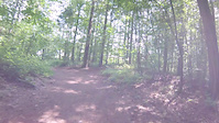
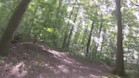
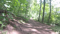
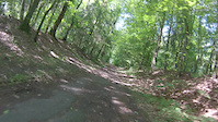
Photos of Kiel Mountain Bike
Videos of Kiel Mountain Bike
trail: Sprotten Trail
0:41 |
147 |
Jun 3, 2019
trail: Hassee
0:55 |
107 |
Jun 3, 2019
trail: Lonely Wolf
0:01 |
105 |
Jun 3, 2019
trail: Viehburg Flow
0:29 |
103 |
Jun 3, 2019
trail: Reach
0:06 |
2081 |
Jan 28, 2016
trail: Reach
4:41 |
349 |
Oct 10, 2014
trail: Bonobo
2:40 |
331 |
Jul 13, 2013

trail: Bonobo
12:50 |
490 |
Dec 6, 2011
Recent Trail Reports
| status | trail | date | condition | info | user |
|---|---|---|---|---|---|
| Lummerbruch | Aug 24, 2022 @ 8:24am Aug 24, 2022 | Dry | BalticMoe | ||
| Wildschwein-Trail | Aug 6, 2022 @ 8:46am Aug 6, 2022 | Ideal | tsurugi68 | ||
| Woody | Aug 6, 2022 @ 8:46am Aug 6, 2022 | Ideal | tsurugi68 | ||
| Pippi Langstrumpf | Aug 6, 2022 @ 8:46am Aug 6, 2022 | Ideal | tsurugi68 | ||
| Muckefuck | Aug 6, 2022 @ 8:46am Aug 6, 2022 | Ideal | tsurugi68 | ||
| Kieler Alpen | Aug 6, 2022 @ 8:46am Aug 6, 2022 | Ideal | tsurugi68 | ||
| Falkenhorst | Aug 6, 2022 @ 8:46am Aug 6, 2022 | Ideal | tsurugi68 | ||
| Mailman | Jul 23, 2021 @ 8:46am Jul 23, 2021 | Very Dry | Frikadilln | ||
| Hasselberg | Jun 16, 2021 @ 7:59am Jun 16, 2021 | Ideal | BalticMoe | ||
| MC Hammer | Jun 5, 2021 @ 10:50pm Jun 5, 2021 | Ideal | BalticMoe |
Activity Feed
| username | action | type | title | date |
|---|---|---|---|---|
| ch4rl3x | wishlist | region | activity #92644221 | Apr 14, 2026 @ 11:56pm Apr 14, 2026 |
| BjrnZXVd2H | ridden | trail | activity #90027448 | Mar 5, 2026 @ 1:25pm Mar 5, 2026 |
| TheForeigner | ridden | trail | activity #83675127 and 2 more | Nov 6, 2025 @ 9:17am Nov 6, 2025 |
| KaijFgxkz | comment | trail | activity #83152142 and 1 more | Oct 28, 2025 @ 2:43am Oct 28, 2025 |
| MrJeffHunteroJwDJS | wishlist | trail | activity #76666375 | Jul 25, 2025 @ 7:51am Jul 25, 2025 |
Recent Comments
| username | type | title | comment | date |
|---|---|---|---|---|
| trail | Das ist nicht der Kraftswerkstrail und der ist... | Aug 9, 2021 @ 1:41am Aug 9, 2021 | ||
| trail | Dämlicher Name und viel zu lang... | Aug 9, 2021 @ 1:34am Aug 9, 2021 | ||
| trail | ...und dumm dazu, weil die Stadt sowas... | Aug 9, 2021 @ 1:28am Aug 9, 2021 | ||
| trail | Das ist der Brunshörn Trail | Aug 9, 2021 @ 1:14am Aug 9, 2021 | ||
| trail | Vorsicht Wanderer/Spaziergänger. Das ist ein... | Aug 9, 2021 @ 1:13am Aug 9, 2021 |
Local Badges
-

10 Green Trails6 awarded -

10 Blue Trails2 awarded -

Epic Ride Climb 2k5 awarded -

Climbing 10k Badge5 awarded -

Climbing 100k Badge1 awarded -

Epic Ride Descent 2k5 awarded
Bike & Skill Parks
| name | type | city | rating |
|---|---|---|---|
| Flachland Freeride | skill park | Kiel | |
| Pumptrack Neumühlen-Dietrichsdorf | skill park | Kiel |
Activity Type Stats
| activitytype | trails | distance | descent | descent distance | total vertical | rating | global rank | state rank | photos | reports | routes | ridelogs |
|---|---|---|---|---|---|---|---|---|---|---|---|---|
| Mountain Bike | 92 | 32 miles | 5,230 ft | 16 miles | 262 ft | #2,368 | #24 | 19 | 64 | 1,979 | ||
| E-Bike | 92 | 32 miles | 5,230 ft | 16 miles | 262 ft | #2,506 | #46 | 55 | 249 | |||
| Horse | 3 | 141 ft | 7 ft | 141 ft | 10 ft | #509 | #7 | 43 | ||||
| Hike | 71 | 28 miles | 4,760 ft | 14 miles | 262 ft | #4,385 | #36 | 64 | 155 | |||
| Trail Running | 71 | 28 miles | 4,760 ft | 14 miles | 262 ft | #3,817 | #33 | 64 | 39 | |||
| Dirtbike/Moto | 3 | 141 ft | 7 ft | 141 ft | 10 ft | #388 | #2 | 43 | ||||
| ATV/ORV/OHV | 3 | 141 ft | 7 ft | 141 ft | 10 ft | #257 | #2 | 43 | ||||
| Snowmobile | 3 | 141 ft | 7 ft | 141 ft | 10 ft | #106 | #1 | |||||
| Snowshoe | 3 | 141 ft | 7 ft | 141 ft | 10 ft | #244 | #2 | 2 | ||||
| Downhill Ski | 3 | 141 ft | 7 ft | 141 ft | 10 ft | #374 | #3 | 5 | ||||
| Backcountry Ski | 3 | 141 ft | 7 ft | 141 ft | 10 ft | #260 | #5 | 3 | ||||
| Nordic Ski | 3 | 141 ft | 7 ft | 141 ft | 10 ft | #303 | #8 | 3 |
Frequently Asked Questions About Kiel
▼
What are the best places to ride in Kiel?
Kiel has 1 areas to explore for mountain biking. The top rated areas are:
▼
What are the highest rated mountain biking trails in Kiel?
The highest rated mountain biking trails in Kiel are:
- Sprotten Trail (4.1/5)
- Swedish Corner (4.1/5)
- Viehburg Flow (4.1/5)
- Rammsee (4/5)
- Petersburg DH (4/5)
▼
What is the best time of the year to ride in Kiel?
Based on ride log data, the most popular months to ride in Kiel are:
- June (78 activities)
- November (68 activities)
- September (63 activities)
▼
Where can I park to ride in Kiel?
Check the Kiel trail map for trailhead and parking information. Community members regularly update access and parking details for trails in the area.
- By trailforks
 Trailforks & contributors
 - Admins: Windfinder
- #23255 - 5,500 views
- kiel activity log | embed map of Kiel mountain bike trails |
Downloading of trail gps tracks in kml & gpx formats is enabled for Kiel.
You must login to download files.