close
-
Layers w
- Weather Layers
- Pro
- Pro
- Pro
- Pro
- Pro
- Pro
- More Layers
- Pro
- Pro
- Pro
- Pro
-
Upgrade to

3D
Trail Conditions
- Unknown
- Snow Groomed
- Snow Packed
- Snow Covered
- Snow Cover Partial
- Freeze/thaw Cycle
- Icy
- Prevalent Mud
- Wet
- Variable
- Ideal
- Dry
- Very Dry
Trail Flow (Ridden Direction)
Trailforks scans users ridelogs to determine the most popular direction each trail is ridden. A good flowing trail network will have most trails flowing in a single direction according to their intension.
The colour categories are based on what percentage of riders are riding a trail in its intended direction.
The colour categories are based on what percentage of riders are riding a trail in its intended direction.
- > 96%
- > 90%
- > 80%
- > 70%
- > 50%
- < 50%
- bi-directional trail
- no data
Trail Last Ridden
Trailforks scans ridelogs to determine the last time a trail was ridden.
- < 2 days
- < 1 week
- < 2 weeks
- < 1 month
- < 6 months
- > 6 months
Trail Ridden Direction
The intended direction a trail should be ridden.
- Downhill Only
- Downhill Primary
- Both Directions
- Uphill Primary
- Uphill Only
- One Direction
Contribute Details
Colors indicate trail is missing specified detail.
- Description
- Photos
- Description & Photos
- Videos
Trail Popularity ?
Trailforks scans ridelogs to determine which trails are ridden the most in the last 9 months.
Trails are compared with nearby trails in the same city region with a possible 25 colour shades.
Think of this as a heatmap, more rides = more kinetic energy = warmer colors.
- most popular
- popular
- less popular
- not popular
ATV/ORV/OHV Filter
Max Vehicle Width
inches
US Cell Coverage
Legend

Radar Time
Activity Recordings
Trailforks uses anonymized public activity data.
?
Activity Recordings
Trailforks uses anonymized public activity data.
?
Personal Heatmap
▶
Activity Types
all
/
none
▶
Options
2
Date range
month
–
Winter Trails
Warning
A routing network for winter maps does not exist. Selecting trails using the winter trails layer has been disabled.
Missing Trails
Most Popular
Least Popular
Trails are colored based on popularity. The more popular a trail is, the more red. Less popular trails trend towards green.
Jump Magnitude Heatmap
Heatmap of where riders jump on trails. Zoom in to see individual jumps, click circles to view jump details.
BC Backroad Status
![map legend]()
Service Road Atlas is a free to use, community-driven service for viewing and creating reports on the numerous back-country service roads around B.C. and Alberta.

Slope Aspect
Direction the slope faces
Trails Deemphasized
Trails are shown in grey.
Only show trails with no bike usage.
Suggested Layers
Based on selected activity type
Save the current map location and zoom level as your default home location whenever this page is loaded.
SavePopular Trail Networks
view all areas »
No description for Kings County has been added yet!
Login or register to submit one.
Stats
- Avg Trail Rating
- Trails (view details)
- 387
- Trails Mountain Bike
- 339
- Trails E-Bike
- 140
- Trails Winter Fat Bike
- 1
- Trails Horse
- 77
- Trails Hike
- 381
- Trails Trail Running
- 373
- Trails Dirtbike/Moto
- 85
- Trails Observed Trials
- 1
- Trails ATV/ORV/OHV
- 94
- Trails Snowmobile
- 72
- Trails Snowshoe
- 257
- Trails Downhill Ski
- 10
- Trails Backcountry Ski
- 5
- Trails Nordic Ski
- 145
- Total Distance
- 332 miles
- Total Descent
- 27,041 ft
- Total Vertical
- 879 ft
- Highest Trailhead
- 888 ft
- Reports
- 851
- Photos
- 147
- Ridden Counter
- 19,659
Articles
Kentville, Nova Scotia Set to Host Canadian XC Championships
Jun 22, 2023 from pinkbike.com
The first time in twenty years that the Canadian Championships will take place in Nova Scotia.
Sub Regions
- Berwick (58)
- Black Rock Community Trails (13)
- Blue Ridge Farm (5)
- Foote Woods (16)
- Canning (11)
- Coldbrook (23)
- Falmouth (93)
- Greenwood (8)
- Kentville (123)
- Bird Sanctuary (24)
- Miner's Marsh (7)
- Mitchell Brook (22)
- Sand Pit (3)
- The Dump (5)
- The Gorge (46)
- Middleton (8)
- New Minas (3)
- Scots Bay (6)
- Windsor (50)
- Wolfville (36)
- Anima Mundi (7)
- Reservoir Park (14)
- White Rock Community Trails (7)
- Centreville Recreation Park (0)
Popular Kings County Mountain Biking Trails
• 100 ★ 4.0 • 538 ft • 0 ft • 348 •
Lots of roots, rocks and trees, most ride this downhill.
• 80 ★ 4.6 • 1,375 ft • 0 ft • 342 •
This trail has been part of for what seems like forever! Rooty, rocky and plenty of good technical fun!! TTF's include several small drops, jumps, berms, bridges and a rock garden. Most ride this downhill but you can climb it too for...
• 90 ★ 4.0 • 551 ft • 31 ft • 316 •
Smoother segment of trail, open and flowy, great ride both up and down.
Lower Stadium Permanently Closed
• 70 ★ 4.0 • 922 ft • 57 ft • 285 •
Lost due to flooding and changing stream patterns. Ride / hike at own risk.
• 75 ★ 3.7 • 546 ft • 0 ft • 264 •
Popular blue difficulty singletrack. This mountain bike primary trail can be used downhill primary and has a easy overall physical rating with a 0 ft blue climb. It features a-frame. On average it takes minutes to complete this trail.
• 80 ★ 1.0 • 420 ft • 17 ft • 252 •
Older side trail with plenty of rough roots. Good for climbing and descending.
• 80 ★ 3.0 • 1,716 ft • 5 ft • 252 •
Popular green difficulty singletrack. This mountain bike primary trail and has a easy overall physical rating with a 5 ft green climb. It features berm, drop and jump. On average it takes 2 minutes to complete this trail.
• 55 ★ 3.5 • 640 ft • 7 ft • 250 •
Wider machine built trail with fun rollers, berms a few bridges and other TTF's. Great place to start your ride at .
Kings County Mountain Bike Routes
Canadian Champs Elite XCO 2024 Featured
4 miles • 380 ft • 13 • Loop •
Proposed route for the 2024 Canadian Championships XCO races July 20-21 2024 in Kentville Nova Scotia....
3 miles • 306 ft • 10 •
Proposed route for the 2024 Canadian Championships Challenge XCO races July 20-21 2024 in Kentville Nova...
31 miles • 1,806 ft • 1 • Loop •
This loop starts at the carpool parking lot in St Croix, it is mostly on former logging roads but there...
1 mile • 71 ft • 1 •
Proposed route for the 2024 Canadian Championships Short Track (XCC) races held July 18 2024 in Kentville...
1 mile • 60 ft • 2 •
Proposed route for the 2024 Canadian Championships Team Really and Youth (U9/U11 XCO races July 20-21 2024...
34 miles • 1,708 ft • 0 •
Mainly old logging roads through the hills of NS. There is one area that is off road and requires you to...
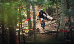
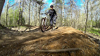
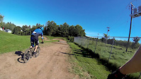
Photos of Kings County Mountain Bike
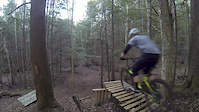
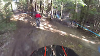
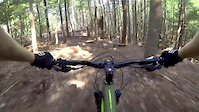
Videos of Kings County Mountain Bike
trail: Endorphin
2:54 |
6659 |
Dec 13, 2015
trail: Purple Hayes
5:10 |
952 |
Nov 12, 2015
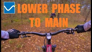
trail: Lower Phase 2 - Main
0:22 |
9156 |
Aug 30, 2015
trail: Reservoir Loop
2:06 |
936 |
May 23, 2015
0:44 |
222 |
Jan 18, 2015
trail: Bunny Hill
0:47 |
87 |
Jan 28, 2013
trail: Bunny Hill
0:53 |
152 |
Jan 28, 2013
trail: Lower Phase 2 - Main
4:56 |
390 |
Nov 10, 2021 , Kentville
Recent Trail Reports
Activity Feed
| username | action | type | title | date |
|---|---|---|---|---|
| DannyBurns | ridden | trail | activity #97007794 | Jun 14, 2026 @ 3:09pm Jun 14, 2026 |
| cs2100 | ridden | trail | activity #96837873 | Jun 12, 2026 @ 5:18pm Jun 12, 2026 |
| cs2100 | ridden | trail | activity #96771129 | Jun 11, 2026 @ 5:13pm Jun 11, 2026 |
| cs2100 | ridden | trail | activity #96771111 | Jun 11, 2026 @ 5:13pm Jun 11, 2026 |
| cs2100 | ridden | trail | activity #96770107 | Jun 11, 2026 @ 4:59pm Jun 11, 2026 |
Recent Comments
| username | type | title | comment | date |
|---|---|---|---|---|
| trail | Lots and lots of roots | Oct 19, 2025 @ 7:59am Oct 19, 2025 | ||
| trail | Uphill part of the loop has a spot where I... | Jul 12, 2025 @ 3:56pm Jul 12, 2025 | ||
| report | Further background on the story of Fielding... | Sep 14, 2023 @ 6:55am Sep 14, 2023 | ||
| report | This is a Provincial K-class road, meaning it... | Sep 14, 2023 @ 6:48am Sep 14, 2023 | ||
| trail | Trails are almost universally rode-ou t and... | Aug 20, 2023 @ 12:44pm Aug 20, 2023 |
Local Badges
-

Top 10 Trails14 awarded -
Top 10 Trails26 awarded -
Top 10 Trails1 awarded -
Top 10 Trails1 awarded -
Top 10 Trails3 awarded -

Completionist1 awarded
Bike & Skill Parks
| name | type | city | rating |
|---|---|---|---|
| Chute Park | skill park | Berwick | |
| Reservoir Park Skills Park | skill park | Wolfville | |
| Burgher Hill Kentville Jump/Flow Trail | skill park | Kentville | |
| Gorge Skills Park | skill park | Kentville | |
| Wolfville Skate Park | skill park | Wolfville |
Activity Type Stats
| activitytype | trails | distance | descent | descent distance | total vertical | rating | global rank | state rank | photos | reports | routes | ridelogs |
|---|---|---|---|---|---|---|---|---|---|---|---|---|
| Mountain Bike | 339 | 309 miles | 21,483 ft | 131 miles | 879 ft | 144 | 851 | 13 | 11,864 | |||
| E-Bike | 140 | 221 miles | 11,444 ft | 96 miles | 869 ft | 1 | 645 | 1 | 711 | |||
| Winter Fat Bike | 1 | 4 | ||||||||||
| Horse | 77 | 168 miles | 10,584 ft | 79 miles | 860 ft | 243 | 19 | |||||
| Hike | 381 | 325 miles | 23,986 ft | 136 miles | 879 ft | 1 | 850 | 1,112 | ||||
| Trail Running | 373 | 324 miles | 23,911 ft | 135 miles | 879 ft | 850 | 745 | |||||
| Dirtbike/Moto | 85 | 175 miles | 10,394 ft | 81 miles | 853 ft | 297 | 1 | 33 | ||||
| Observed Trials | 1 | 5 miles | 187 ft | 2 miles | 98 ft | 1 | ||||||
| ATV/ORV/OHV | 94 | 195 miles | 10,545 ft | 87 miles | 850 ft | 298 | 1 | 17 | ||||
| Snowmobile | 72 | 194 miles | 10,194 ft | 86 miles | 850 ft | 13 | 1 | |||||
| Snowshoe | 257 | 230 miles | 14,905 ft | 98 miles | 869 ft | 223 | 76 | |||||
| Downhill Ski | 10 | 5 miles | 2,910 ft | 4 miles | 679 ft | 1 | 12 | 402 | ||||
| Backcountry Ski | 5 | 6 miles | 367 ft | 3 miles | 679 ft | 56 | ||||||
| Nordic Ski | 145 | 222 miles | 11,286 ft | 92 miles | 869 ft | 175 | 152 |
Activities
- Kings County Mountain Biking Trails
- Kings County E-Biking Trails
- Kings County Horseback Trails
- Kings County Hiking Trails
- Kings County Trail Running Trails
- Kings County Dirtbiking Trails
- Kings County ATVing/Offroading Trails
- Kings County Snowmobiling Trails
- Kings County Snowshoeing Trails
- Kings County Skiing Trails
- Kings County Backcountry Skiing Trails
- Kings County Nordic Skiing Trails
Trails
- By Myatt & contributors
- Admins: bent6543, AVMBA
- #7097 - 12,867 views
- kings county activity log | embed map of Kings County mountain bike trails | kings county mountain biking points of interest
Downloading of trail gps tracks in kml & gpx formats is enabled for Kings County.
You must login to download files.