close
-
Layers w
- Weather Layers
- Pro
- Pro
- Pro
- Pro
- Pro
- Pro
- More Layers
- Pro
- Pro
- Pro
- Pro
-
Upgrade to

3D
Trail Conditions
- Unknown
- Snow Groomed
- Snow Packed
- Snow Covered
- Snow Cover Partial
- Freeze/thaw Cycle
- Icy
- Prevalent Mud
- Wet
- Variable
- Ideal
- Dry
- Very Dry
Trail Flow (Ridden Direction)
Trailforks scans users ridelogs to determine the most popular direction each trail is ridden. A good flowing trail network will have most trails flowing in a single direction according to their intension.
The colour categories are based on what percentage of riders are riding a trail in its intended direction.
The colour categories are based on what percentage of riders are riding a trail in its intended direction.
- > 96%
- > 90%
- > 80%
- > 70%
- > 50%
- < 50%
- bi-directional trail
- no data
Trail Last Ridden
Trailforks scans ridelogs to determine the last time a trail was ridden.
- < 2 days
- < 1 week
- < 2 weeks
- < 1 month
- < 6 months
- > 6 months
Trail Ridden Direction
The intended direction a trail should be ridden.
- Downhill Only
- Downhill Primary
- Both Directions
- Uphill Primary
- Uphill Only
- One Direction
Contribute Details
Colors indicate trail is missing specified detail.
- Description
- Photos
- Description & Photos
- Videos
Trail Popularity ?
Trailforks scans ridelogs to determine which trails are ridden the most in the last 9 months.
Trails are compared with nearby trails in the same city region with a possible 25 colour shades.
Think of this as a heatmap, more rides = more kinetic energy = warmer colors.
- most popular
- popular
- less popular
- not popular
ATV/ORV/OHV Filter
Max Vehicle Width
inches
US Cell Coverage
Legend

Radar Time
Activity Recordings
Trailforks uses anonymized public activity data.
?
Activity Recordings
Trailforks uses anonymized public activity data.
?
Personal Heatmap
▶
Activity Types
all
/
none
▶
Options
2
Date range
month
–
Winter Trails
Warning
A routing network for winter maps does not exist. Selecting trails using the winter trails layer has been disabled.
Missing Trails
Most Popular
Least Popular
Trails are colored based on popularity. The more popular a trail is, the more red. Less popular trails trend towards green.
Jump Magnitude Heatmap
Heatmap of where riders jump on trails. Zoom in to see individual jumps, click circles to view jump details.
BC Backroad Status
![map legend]()
Service Road Atlas is a free to use, community-driven service for viewing and creating reports on the numerous back-country service roads around B.C. and Alberta.

Slope Aspect
Direction the slope faces
Trails Deemphasized
Trails are shown in grey.
Only show trails with no bike usage.
Suggested Layers
Based on selected activity type
Save the current map location and zoom level as your default home location whenever this page is loaded.
SaveKinross State Forest is a medium sized area offering trails from Easy riding through to Very Difficult.
(currently closed for logging July 2021)
(currently closed for logging July 2021)
Primary Trail Type: Cross-Country
Shuttleable: YES
AKA: Kinross
Land Status: State Forest
 google parking directions
 Access Info:
Car Park at the entry to Kinross State Forest on Bulgas Road.
Links
Activities Click to view
- Mountain Bike
39 trails
- E-Bike
1 trails
- Hike
40 trails
- Trail Running
40 trails
Region Details
- 3
- 17
- 17
- 2
Region Status
Open as of Oct 3, 2025Stats
- Avg Trail Rating
- Trails (view details)
- 39
- Trails Mountain Bike
- 39
- Trails E-Bike
- 1
- Trails Hike
- 40
- Trails Trail Running
- 40
- Total Distance
- 18 miles
- Total Descent
- 3,422 ft
- Total Vertical
- 418 ft
- Highest Trailhead
- 3,256 ft
- Reports
- 153
- Photos
- 42
- Ridden Counter
- 2,473
Popular Kinross State Forest Mountain Biking Trails
Simmo's Special Permanently Closed
• 5 ★ 0.0 • 2,995 ft • 7 ft • 63 •
Less popular blue difficulty closed singletrack. This mountain bike primary trail can be used both directions and has a hard overall physical rating with a 7 ft blue climb. On average it takes 3 minutes to complete this trail.
Nathans Track Permanently Closed
• 5 ★ 4.0 • 2,480 ft • 39 ft • 57 •
Less popular green difficulty closed singletrack. This mountain bike primary trail can be used both directions. On average it takes 6 minutes to complete this trail.
Hot for Teacher Permanently Closed
• 5 ★ 0.0 • 1 mile • 165 ft • 54 •
The full trail in the Eastern section of Kinross as endorsed by Orange Mountain Bike Club
The Gymp Permanently Closed
• 5 ★ 4.0 • 2,493 ft • 57 ft • 50 •
Less popular blue difficulty closed singletrack. This mountain bike primary trail can be used both directions. On average it takes 5 minutes to complete this trail.
Jeep Track Permanently Closed
• 5 ★ 4.0 • 2,001 ft • 59 ft • 47 •
Less popular blue difficulty closed singletrack. This mountain bike primary trail can be used both directions. On average it takes 3 minutes to complete this trail.
Lost Valley Permanently Closed
• 5 ★ 4.0 • 3,255 ft • 46 ft • 29 •
Less popular blue difficulty closed singletrack. This mountain bike primary trail can be used downhill primary and has a moderate overall physical rating with a 46 ft blue climb. On average it takes 7 minutes to complete this trail.
Jeep Link Permanently Closed
• 5 ★ 0.0 • 932 ft • 58 ft • 23 •
Less popular green difficulty closed singletrack. This mountain bike primary trail can be used both directions. On average it takes 2 minutes to complete this trail.
Kinross State Forest Mountain Bike Routes
5 miles • 531 ft • 27 • Loop •
Updated Ninja Loop takes in a range of differing tracks than the previous version and makes for a fun ride.
5 miles • 478 ft • 15 • Loop •
This route takes in a good swag of trails in Kinross, nothing too technically difficult but some good...
3 miles • 410 ft • 3 •
New Southern loop for 2021!! Trees cleared in July Still open and approved by forestry 2021
3 miles • 420 ft • 9 • Loop • Race •
Mountain Bike Australia in conjunction with Orange Mountain Bike Club & Orange City Council ran Round 1...
★ 2.0 • 4 miles • 590 ft • 9 • Loop • Race •
Mountain Bike Australia in conjunction with Orange Mountain Bike Club & Orange City Council ran Round 1...
9 miles • 1,229 ft • 16 • Loop • Race •
Our event course. A 'Mini' gravity enduro. Note that there's a mandatory practice run of each stage before...
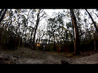
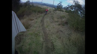
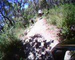
Photos of Kinross State Forest Mountain Bike
Videos of Kinross State Forest Mountain Bike
trail: North Shore
0:07 |
633 |
Jun 24, 2013
trail: North Shore
2:24 |
235 |
Jun 10, 2012
trail: Race Track
4:02 |
2471 |
Aug 7, 2011
trail: North Shore
2:47 |
269 |
Jan 24, 2011
trail: North Shore
2:59 |
195 |
Jun 18, 2010
trail: North Shore
7:03 |
131 |
Jun 15, 2010

trail: Race Track
3:23 |
3544 |
Jun 15, 2010

trail: North Shore
0:44 |
343 |
Jan 19, 2010
Recent Trail Reports
| status | trail | date | condition | info | user |
|---|---|---|---|---|---|
| Lost Valley | Oct 4, 2025 @ 10:11am (Australia/Sydney) Oct 3, 2025 | Ideal | RomanMark | ||
| North Shore | Jul 22, 2021 @ 2:14am Jul 22, 2021 | Dry | EuanScott | ||
| Bogans Run | Jul 22, 2021 @ 2:13am Jul 22, 2021 | Dry | EuanScott | ||
| Access Road | Jul 22, 2021 @ 2:12am Jul 22, 2021 | Dry | EuanScott | ||
| Goat Track Insider Loop | Jul 22, 2021 @ 2:11am Jul 22, 2021 | Dry | EuanScott | ||
| TTT | Jul 22, 2021 @ 2:11am Jul 22, 2021 | Dry | EuanScott | ||
| Isaac As An Off | Jul 8, 2021 @ 11:15pm Jul 8, 2021 | Dry | Sasquatch72 OMC | ||
| Berm me up Scotty | Mar 1, 2021 @ 3:03pm Mar 1, 2021 | Dry | Craney900 | ||
| Goat Track Outsider Loop | Mar 1, 2021 @ 3:03pm Mar 1, 2021 | Dry | Craney900 | ||
| Walk in the Park | Dec 27, 2020 @ 1:34pm Dec 27, 2020 | Ideal | Tobacious |
Activity Feed
| username | action | type | title | date |
|---|---|---|---|---|
| trailforks | add | video | activity #87259325 | Jan 15, 2026 @ 5:00pm Jan 15, 2026 |
| RomanMark | add | report | activity #81911183 | Oct 7, 2025 @ 4:23pm Oct 7, 2025 |
| Walteroscar63 | wishlist | region | activity #35813234 | Dec 3, 2022 @ 4:39pm Dec 3, 2022 |
| rockspider | vote | trail | activity #32368374 | Aug 11, 2022 @ 4:23am Aug 11, 2022 |
| marlon-d | add | photo | activity #31293090 and 2 more | Jul 11, 2022 @ 10:08am Jul 11, 2022 |
Recent Comments
| username | type | title | comment | date |
|---|---|---|---|---|
| trail | Currently closed at the bottom, meaning you... | Nov 8, 2020 @ 2:18am Nov 8, 2020 | ||
| trail | Short easy track that goes to another easy... | Sep 4, 2018 @ 2:55pm Sep 4, 2018 | ||
| trail | I really enjoyed this track. It's fast with a... | Sep 4, 2018 @ 2:39pm Sep 4, 2018 | ||
| trail | This trail is a whole lotta fun. Lots of small... | Aug 30, 2018 @ 5:07pm Aug 30, 2018 | ||
| trail | As the name suggests, this is an easy trail... | Aug 30, 2018 @ 4:59pm Aug 30, 2018 |
Nearby Areas
| name | distance | ||||
|---|---|---|---|---|---|
| Mullion Creek | 3 | 7 | 6 | 1 | 5.9 km |
| Lake Canobolas Mountain Bike Park | 3 | 7 | 3 | 8.4 km | |
| Mount Canobolas | 10 | 6 | 4 | 11.8 km | |
| Glenwood Forest Trails | 4 | 4 | 1 | 1 | 13.1 km |
| Bathurst Bike Park | 12 | 8 | 27 km |
Local Badges
-

Completionist1 awarded
Activity Type Stats
| activitytype | trails | distance | descent | descent distance | total vertical | rating | global rank | state rank | photos | reports | routes | ridelogs |
|---|---|---|---|---|---|---|---|---|---|---|---|---|
| Mountain Bike | 39 | 18 miles | 3,422 ft | 10 miles | 417 ft | #3,687 | #181 | 81 | 153 | 8 | 2,247 | |
| E-Bike | 1 | 994 ft | 89 ft | 994 ft | 89 ft | #8,181 | #456 | 114 | 50 | |||
| Hike | 40 | 18 miles | 3,422 ft | 10 miles | 417 ft | #7,126 | #223 | 153 | 9 | |||
| Trail Running | 40 | 18 miles | 3,422 ft | 10 miles | 417 ft | #6,311 | #211 | 153 | 69 |
Frequently Asked Questions About Kinross State Forest
▼
What are the highest rated mountain biking trails in Kinross State Forest?
The highest rated mountain biking trails in Kinross State Forest are:
- Goats Connector1 (0/5)
▼
What is the best time of the year to ride in Kinross State Forest?
Based on ride log data, the most popular months to ride in Kinross State Forest are:
- August (22 activities)
- January (21 activities)
- November (20 activities)
▼
Where can I park to ride in Kinross State Forest?
There are 1 parking locations listed in Kinross State Forest. The most popular parking spots are:
▼
What is the longest trail in Kinross State Forest?
The longest trail in Kinross State Forest is Goats Connector1 at 84 ft. View all trails sorted by distance.
Activities
Trails
Points of Interest
- By armageddonactionsports & contributors
- Admins: OMC
- #4755 - 11,757 views
- kinross state forest activity log | embed map of Kinross State Forest mountain bike trails | kinross state forest mountain biking points of interest
Downloading of trail gps tracks in kml & gpx formats is disabled for Kinross State Forest.