close
-
Layers w
- Weather Layers
- Pro
- Pro
- Pro
- Pro
- Pro
- Pro
- More Layers
- Pro
- Pro
- Pro
- Pro
-
Upgrade to

3D
Trail Conditions
- Unknown
- Snow Groomed
- Snow Packed
- Snow Covered
- Snow Cover Partial
- Freeze/thaw Cycle
- Icy
- Prevalent Mud
- Wet
- Variable
- Ideal
- Dry
- Very Dry
Trail Flow (Ridden Direction)
Trailforks scans users ridelogs to determine the most popular direction each trail is ridden. A good flowing trail network will have most trails flowing in a single direction according to their intension.
The colour categories are based on what percentage of riders are riding a trail in its intended direction.
The colour categories are based on what percentage of riders are riding a trail in its intended direction.
- > 96%
- > 90%
- > 80%
- > 70%
- > 50%
- < 50%
- bi-directional trail
- no data
Trail Last Ridden
Trailforks scans ridelogs to determine the last time a trail was ridden.
- < 2 days
- < 1 week
- < 2 weeks
- < 1 month
- < 6 months
- > 6 months
Trail Ridden Direction
The intended direction a trail should be ridden.
- Downhill Only
- Downhill Primary
- Both Directions
- Uphill Primary
- Uphill Only
- One Direction
Contribute Details
Colors indicate trail is missing specified detail.
- Description
- Photos
- Description & Photos
- Videos
Trail Popularity ?
Trailforks scans ridelogs to determine which trails are ridden the most in the last 9 months.
Trails are compared with nearby trails in the same city region with a possible 25 colour shades.
Think of this as a heatmap, more rides = more kinetic energy = warmer colors.
- most popular
- popular
- less popular
- not popular
ATV/ORV/OHV Filter
Max Vehicle Width
inches
US Cell Coverage
Legend

Radar Time
Activity Recordings
Trailforks uses anonymized public activity data.
?
Activity Recordings
Trailforks uses anonymized public activity data.
?
Personal Heatmap
▶
Activity Types
all
/
none
▶
Options
2
Date range
month
–
Winter Trails
Warning
A routing network for winter maps does not exist. Selecting trails using the winter trails layer has been disabled.
Missing Trails
Most Popular
Least Popular
Trails are colored based on popularity. The more popular a trail is, the more red. Less popular trails trend towards green.
Jump Magnitude Heatmap
Heatmap of where riders jump on trails. Zoom in to see individual jumps, click circles to view jump details.
BC Backroad Status
![map legend]()
Service Road Atlas is a free to use, community-driven service for viewing and creating reports on the numerous back-country service roads around B.C. and Alberta.

Slope Aspect
Direction the slope faces
Trails Deemphasized
Trails are shown in grey.
Only show trails with no bike usage.
Suggested Layers
Based on selected activity type
Save the current map location and zoom level as your default home location whenever this page is loaded.
Save
No description for Kirkwood has been added yet!
Login or register to submit one.
Activities Click to view
- Mountain Bike
64 trails
- E-Bike
46 trails
- Gravel Bike
0 trails
- Adaptive Bike
0 trails
- Winter Fat Bike
0 trails
- Horse
45 trails
- Hike
86 trails
- Trail Running
80 trails
- Dirtbike/Moto
8 trails
- ATV/ORV/OHV
6 trails
- Snowshoe
11 trails
- Downhill Ski
62 trails
- Nordic Ski
9 trails
Region Details
- 14
- 10
- 19
- 20
- 1
Region Status
Caution as of Jun 13, 2026Stats
- Avg Trail Rating
- Trails (view details)
- 164
- Trails Mountain Bike
- 64
- Trails E-Bike
- 46
- Trails Horse
- 45
- Trails Hike
- 86
- Trails Trail Running
- 80
- Trails Dirtbike/Moto
- 8
- Trails ATV/ORV/OHV
- 6
- Trails Snowshoe
- 11
- Trails Downhill Ski
- 62
- Trails Backcountry Ski
- 2
- Trails Nordic Ski
- 9
- Total Distance
- 219 miles
- Total Descent
- 66,379 ft
- Total Vertical
- 6,405 ft
- Highest Trailhead
- 10,374 ft
- Reports
- 2,660
- Photos
- 61
- Ridden Counter
- 28,826
Sub Regions
-
Caples Creek
- 2
- 7
- 1
-
Kirkwood Mountain Resort
- 6
- 15
- 8
Popular Kirkwood Mountain Biking Trails
• 95 ★ 3.0 • 2 miles • 544 ft • 161 •
This is the connector trail to avoid riding on highway 88. Great view of Caples Creek and Thunder MT. Mostly single track.
• 100 ★ 4.4 • 5,023 ft • 0 ft • 137 •
Popular blue difficulty singletrack. This mountain bike primary trail can be used downhill primary and has a moderate overall physical rating with a 0 ft blue climb. It features berm and drop. On average it takes 6 minutes to complete this trail.
• 95 ★ 0.0 • 1,877 ft • 10 ft • 120 •
Short little trail from Hole' N Wall and , connects Danberg to
• 90 ★ 0.0 • 2,277 ft • 95 ft • 114 •
Alternate trail to avoid climbing on Highway 88
• 100 ★ 0.0 • 2,743 ft • 0 ft • 102 •
Popular blue difficulty singletrack. This mountain bike primary trail can be used both directions and has a moderate overall physical rating with a 0 ft black diamond climb. Trail visibility is always easy to follow. On average it takes 2 minutes to complete this trail.
• 85 ★ 5.0 • 1,975 ft • 4 ft • 41 •
Constructed during the summer season of 2023, this trail features table top jumps, berms, natural rock features, a few steep sections, and Kirkwood's first road gap jump. The trail merges with the briefly and the lower section will spur...
• 100 ★ 5.0 • 1,975 ft • 0 ft • 28 •
Technical singletrack trail featuring exposed rock rolls, a wood berm, and scenic views of Timber Creek. Access from Dangberg trail just north of the intersection with the Chair 7 service road.
• 5 ★ 4.0 • 3 miles • 26 ft • 27 •
The start of this trail isn't always maintained the best. But has been cleared in the last year. After the first 0.6 miles it clears out is regularly kept up. It is best done as a point to point. The trail gets steep in spots and have...
Kirkwood Mountain Bike Routes
★ 5.0 • 16 miles • 849 ft • 5 • Point to Point •
This trail showcases some of the region's most rugged and expansive granite terrain—steep, chunky, and...
25 miles • 4,802 ft • 16 •
VIRTUAL Kirkwood Kruise MEGA RIDE!! Our second Virtual Route of the summer goes live September 1st through...
13 miles • 2,009 ft • 11 • Point to Point •
The VIRTUAL Kirkwood Kruise route is now LIVE through August 30th! Whether you're out for a mellow cruise...
10 miles • 1,801 ft • 8 •
The is the intermediate ride route for the Peak Pursuits women's mountain bike event September 19-21, 2025.
16 miles • 3,496 ft • 11 •
This is the Advanced Route for the Peak Pursuits women's mountain bike event, September 19-21, 2025.
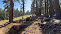
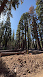
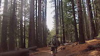
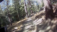
Photos of Kirkwood Mountain Bike
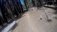
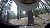
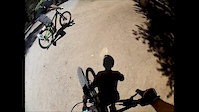
Videos of Kirkwood Mountain Bike
trail: Upper Jemma's Jungle
0:05 |
46 |
Oct 17, 2024
trail: Upper Jemma's Jungle
0:04 |
21 |
Oct 17, 2024
trail: Lower Corral
4:52 |
166 |
Jun 6, 2016
trail: Upper Corral
2:08 |
124 |
Oct 25, 2015
trail: Upper Corral
0:42 |
205 |
Jun 27, 2015
trail: Upper Corral
17:21 |
251 |
Aug 19, 2014
trail: Lower Corral
6:58 |
183 |
Jun 27, 2013
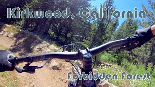
trail: Forbidden Forest
2:42 |
53 |
Jul 18, 2025 , Kirkwood
Recent Trail Reports
| status | trail | date | condition | info | user |
|---|---|---|---|---|---|
| Scouts Route | Jun 13, 2026 @ 12:14pm (America/Los_Angeles) Jun 13, 2026 | Ideal | chadrcox | ||
| Upper Jemma's Jungle | Jun 13, 2026 @ 12:13pm (America/Los_Angeles) Jun 13, 2026 | Ideal | chadrcox | ||
| Robey Wolfe | Jun 12, 2026 @ 5:01pm (America/Los_Angeles) Jun 12, 2026 | Ideal | chadrcox | ||
| Cutback | Jun 12, 2026 @ 5:01pm (America/Los_Angeles) Jun 12, 2026 | Unknown | chadrcox | ||
| Thunder Mountain Summit | Mar 28, 2026 @ 11:10am (America/Los_Angeles) Mar 28, 2026 | Dry | diegs222 | ||
| Whiskey Shots | Nov 16, 2025 @ 12:51am (America/Los_Angeles) Nov 16, 2025 | Snow Covered | DoubleDuff KMR | ||
| Whiskey Shots | Nov 16, 2025 @ 12:51am (America/Los_Angeles) Nov 16, 2025 | Snow Covered | DoubleDuff KMR | ||
| Whiskey Alt | Nov 16, 2025 @ 12:51am (America/Los_Angeles) Nov 16, 2025 | Snow Covered | DoubleDuff KMR | ||
| Whiskey | Nov 16, 2025 @ 12:51am (America/Los_Angeles) Nov 16, 2025 | Snow Covered | DoubleDuff KMR | ||
| West Meadow | Nov 16, 2025 @ 12:51am (America/Los_Angeles) Nov 16, 2025 | Snow Covered | DoubleDuff KMR |
Activity Feed
| username | action | type | title | date |
|---|---|---|---|---|
| chadrcox | add | report | activity #96904336 and 1 more | Jun 13, 2026 @ 12:13pm Jun 13, 2026 |
| robarta | add | report | activity #96882141 | Jun 13, 2026 @ 8:41am Jun 13, 2026 |
| robarta | add | report | activity #96881841 and 1 more | Jun 13, 2026 @ 8:39am Jun 13, 2026 |
| chadrcox | add | report | activity #96836849 and 1 more | Jun 12, 2026 @ 5:01pm Jun 12, 2026 |
| CAEZ | wishlist | trail | activity #96415796 | Jun 6, 2026 @ 4:45pm Jun 6, 2026 |
Recent Comments
| username | type | title | comment | date |
|---|---|---|---|---|
| trail | This trail is excellent! Kudos to the trail... | Sep 15, 2025 @ 7:24am Sep 15, 2025 | ||
| trail | Trail did survive the fire, majority of the... | Jul 26, 2025 @ 10:20pm Jul 26, 2025 | ||
| trail | not currently rideable since caldor fire.... | Jul 21, 2025 @ 7:48am Jul 21, 2025 | ||
| trail | If you try to ascend from the bottom, and you... | Jul 18, 2025 @ 11:31am Jul 18, 2025 | ||
| trail | Just completed black mostly technical trail,... | Jul 18, 2025 @ 11:28am Jul 18, 2025 |
Local Badges
-

10 Blue Trails24 awarded -

Epic Ride Climb 2k28 awarded -

Climbing 10k Badge3 awarded -

Climbing 100k Badge0 awarded -

Epic Ride Descent 2k53 awarded -

Descent 10k Badge7 awarded
Bike & Skill Parks
| name | type | city | rating |
|---|---|---|---|
| Kirkwood Mountain Resort | bike park | Kirkwood | |
| Kirkwood Pumptrack | skill park | Kirkwood | |
| Kirkwood Development Area | skill park | Kirkwood |
Activity Type Stats
| activitytype | trails | distance | descent | descent distance | total vertical | rating | global rank | state rank | photos | reports | routes | ridelogs |
|---|---|---|---|---|---|---|---|---|---|---|---|---|
| Mountain Bike | 64 | 72 miles | 13,054 ft | 34 miles | 3,957 ft | #2,733 | #977 | 60 | 2,649 | 10 | 1,539 | |
| E-Bike | 46 | 54 miles | 7,759 ft | 23 miles | 3,924 ft | #2,528 | #1,016 | 2,265 | 3 | 130 | ||
| Horse | 45 | 96 miles | 17,539 ft | 41 miles | 3,940 ft | #500 | #503 | 1,542 | 2 | |||
| Hike | 86 | 178 miles | 38,681 ft | 86 miles | 6,404 ft | #999 | #451 | 2,102 | 28 | 1,280 | ||
| Trail Running | 80 | 173 miles | 38,615 ft | 86 miles | 6,404 ft | #942 | #354 | 2,101 | 6 | 141 | ||
| Dirtbike/Moto | 8 | 16 miles | 1,621 ft | 6 miles | 2,802 ft | #876 | #324 | 325 | 4 | |||
| ATV/ORV/OHV | 6 | 11 miles | 423 ft | 2 miles | 2,188 ft | #742 | #313 | 321 | 1 | |||
| Snowshoe | 11 | 8 miles | 328 ft | 2 miles | 1,814 ft | #643 | #261 | 73 | 66 | |||
| Downhill Ski | 62 | 25 miles | 24,780 ft | 23 miles | 1,791 ft | #77 | #34 | 73 | 5,246 | |||
| Backcountry Ski | 2 | 2 miles | 98 ft | 3,045 ft | 509 ft | 5 | 750 | |||||
| Nordic Ski | 9 | 6 miles | 230 ft | 2 miles | 194 ft | #819 | #323 | 73 | 236 |
Frequently Asked Questions About Kirkwood
▼
What are the best places to ride in Kirkwood?
Kirkwood has 3 areas to explore for mountain biking. The top rated areas are:
▼
What are the highest rated mountain biking trails in Kirkwood?
The highest rated mountain biking trails in Kirkwood are:
- Scouts Route (4.2/5)
- Forbidden Forest (4.1/5)
- Vista (4.1/5)
- Caples Creek Trail (Upper) (4/5)
- Silver Fork Trail (4/5)
▼
What is the best time of the year to ride in Kirkwood?
Based on ride log data, the most popular months to ride in Kirkwood are:
- July (43 activities)
- June (32 activities)
- August (22 activities)
▼
Where can I park to ride in Kirkwood?
There are 16 parking locations listed in Kirkwood. The most popular parking spots are: View all parking and trailhead locations on the map to plan your visit.
Activities
Trails
Points of Interest
- Kirkwood Disc Golf Course Information
- Carson Pass Information
- Kirkwood Mountain Resort Lodge
- Kirkwood Cross Country Center Lodge
- Camp Irene Camping
- Kirkwood Lake Campground Camping
- Hope Valley Campground Camping
- The Nipple Summit
- Middle Creek Campground Camping
- Lost Campsites Camping
- Round Top (3,160 m)
- The Sisters (3,064 m)
- Tryon Peak (3,041 m)
- By Bassman87 & contributors
- Admins: TAMBA, TheAngryTomato
- #4337 - 7,385 views
- kirkwood activity log | embed map of Kirkwood mountain bike trails | kirkwood mountain biking points of interest
Downloading of trail gps tracks in kml & gpx formats is enabled for Kirkwood.
You must login to download files.