close
-
Layers w
- Weather Layers
- Pro
- Pro
- Pro
- Pro
- Pro
- Pro
- More Layers
- Pro
- Pro
- Pro
- Pro
-
Upgrade to

3D
Trail Conditions
- Unknown
- Snow Groomed
- Snow Packed
- Snow Covered
- Snow Cover Partial
- Freeze/thaw Cycle
- Icy
- Prevalent Mud
- Wet
- Variable
- Ideal
- Dry
- Very Dry
Trail Flow (Ridden Direction)
Trailforks scans users ridelogs to determine the most popular direction each trail is ridden. A good flowing trail network will have most trails flowing in a single direction according to their intension.
The colour categories are based on what percentage of riders are riding a trail in its intended direction.
The colour categories are based on what percentage of riders are riding a trail in its intended direction.
- > 96%
- > 90%
- > 80%
- > 70%
- > 50%
- < 50%
- bi-directional trail
- no data
Trail Last Ridden
Trailforks scans ridelogs to determine the last time a trail was ridden.
- < 2 days
- < 1 week
- < 2 weeks
- < 1 month
- < 6 months
- > 6 months
Trail Ridden Direction
The intended direction a trail should be ridden.
- Downhill Only
- Downhill Primary
- Both Directions
- Uphill Primary
- Uphill Only
- One Direction
Contribute Details
Colors indicate trail is missing specified detail.
- Description
- Photos
- Description & Photos
- Videos
Trail Popularity ?
Trailforks scans ridelogs to determine which trails are ridden the most in the last 9 months.
Trails are compared with nearby trails in the same city region with a possible 25 colour shades.
Think of this as a heatmap, more rides = more kinetic energy = warmer colors.
- most popular
- popular
- less popular
- not popular
ATV/ORV/OHV Filter
Max Vehicle Width
inches
US Cell Coverage
Legend

Radar Time
Activity Recordings
Trailforks uses anonymized public activity data.
?
Activity Recordings
Trailforks uses anonymized public activity data.
?
Personal Heatmap
▶
Activity Types
all
/
none
▶
Options
2
Date range
month
–
Winter Trails
Warning
A routing network for winter maps does not exist. Selecting trails using the winter trails layer has been disabled.
Missing Trails
Most Popular
Least Popular
Trails are colored based on popularity. The more popular a trail is, the more red. Less popular trails trend towards green.
Jump Magnitude Heatmap
Heatmap of where riders jump on trails. Zoom in to see individual jumps, click circles to view jump details.
BC Backroad Status
![map legend]()
Service Road Atlas is a free to use, community-driven service for viewing and creating reports on the numerous back-country service roads around B.C. and Alberta.

Slope Aspect
Direction the slope faces
Trails Deemphasized
Trails are shown in grey.
Only show trails with no bike usage.
Suggested Layers
Based on selected activity type
Save the current map location and zoom level as your default home location whenever this page is loaded.
Save
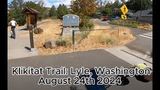
No description for Klickitat has been added yet!
Login or register to submit one.
Activities Click to view
- Mountain Bike
5 trails
- Hike
5 trails
- Trail Running
5 trails
Stats
- Avg Trail Rating
- Trails (view details)
- 3
- Trails Mountain Bike
- 5
- Trails E-Bike
- 2
- Trails Adaptive Bike
- 1
- Trails Hike
- 5
- Trails Trail Running
- 5
- Total Distance
- 29 miles
- Total Descent Distance
- 16 miles
- Total Descent
- 1,121 ft
- Total Vertical
- 1,426 ft
- Highest Trailhead
- 1,563 ft
- Reports
- 53
- Photos
- 42
- Ridden Counter
- 342
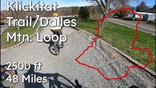
Popular Klickitat Mountain Biking Trails
• 100 ★ 4.7 • 13 miles • 369 ft • 292 •
The Klickitat Trail, a non-motorized multiple use trail, follows the first 31 miles of an old railroad corridor that once linked the towns of Lyle and Goldendale. It is unique among rail trails. Nowhere else is there a rail trail that...
• 35 ★ 0.0 • 14 miles • 0 ft • 12 •
The contrasting beauty of the remote Swale Canyon begins east of Klickitat and continues southeast for 16.4 miles, passing below basalt cliffs (on a somewhat rocky, irregular surface) to the open prairie flatlands of the Golden Plateau....
• 70 ★ 0.0 • 2 miles • 3 ft • 4 •
Popular green difficulty rail trail. This multi-use trail can be used both directions and has a easy overall physical rating with a 3 ft green climb. Trail visibility is always easy to follow.
Photos of Klickitat Mountain Bike
Videos of Klickitat Mountain Bike
trail: Klickitat Trail West
9:23 |
158 |
Aug 27, 2024 , Klickitat
trail: Klickitat Trail West
5:44 |
287 |
Apr 6, 2023 , Klickitat
youtuber
![Klickitat Trail (Lyle Mullet)]()

trail: Klickitat Trail East
18:40 |
376 |
Mar 20, 2021 , Klickitat
youtuber
![Klickitat Trail (Lyle Mullet)]()
trail: Klickitat Trail West
18:40 |
570 |
Mar 20, 2021 , Klickitat
Recent Trail Reports
| status | trail | date | condition | info | user |
|---|---|---|---|---|---|
| Klickitat Trail West | Apr 12, 2026 @ 9:20am (America/Vancouver) Apr 12, 2026 | Ideal | wcortez | ||
| Klickitat Trail East | Mar 14, 2026 @ 3:19pm (America/Vancouver) Mar 14, 2026 | Ideal | RichardDavies | ||
| Klickitat Trail East (Undeveloped) | Mar 9, 2026 @ 12:27pm (America/Los_Angeles) Mar 9, 2026 | Variable | Mdeniston |
Activity Feed
| username | action | type | title | date |
|---|---|---|---|---|
| Keiko-coe | wishlist | trail | activity #95263931 | May 22, 2026 @ 1:14pm May 22, 2026 |
| BethbTPwN | wishlist | trail | activity #95251344 | May 22, 2026 @ 10:07am May 22, 2026 |
| Hawki2 | wishlist | trail | activity #95108067 | May 20, 2026 @ 7:57am May 20, 2026 |
| wcortez | add | report | activity #92510833 | Apr 12, 2026 @ 4:46pm Apr 12, 2026 |
| NatashaJ112 | wishlist | trail | activity #92304681 | Apr 9, 2026 @ 11:55pm Apr 9, 2026 |
Recent Comments
| username | type | title | comment | date |
|---|---|---|---|---|
| trail | Hmmm | Oct 18, 2023 @ 3:32pm Oct 18, 2023 | ||
| trail | The worse tick population I have ever seen,... | May 4, 2022 @ 12:50am May 4, 2022 | ||
| trail | Beautiful ride along the Klickitat river. Saw... | Aug 22, 2021 @ 3:02pm Aug 22, 2021 | ||
| trail | If you’re doing and out and back- the trail... | Feb 7, 2021 @ 8:45am Feb 7, 2021 | ||
| trail | If you take Centerville Hwy from the Lyle... | Feb 7, 2021 @ 8:38am Feb 7, 2021 |
Bike & Skill Parks
| name | type | city | rating |
|---|---|---|---|
| Starvation Ridge | skill park | Klickitat |
Activity Type Stats
| activitytype | trails | distance | descent | descent distance | total vertical | rating | global rank | state rank | photos | reports | routes | ridelogs |
|---|---|---|---|---|---|---|---|---|---|---|---|---|
| Mountain Bike | 5 | 29 miles | 1,122 ft | 16 miles | 1,427 ft | #4,622 | #1,550 | 42 | 53 | 1,349 | ||
| E-Bike | 2 | 37 | 37 | |||||||||
| Adaptive Bike | 1 | #2,383 | #1,021 | 1 | ||||||||
| Hike | 5 | 29 miles | 1,122 ft | 16 miles | 1,427 ft | #7,075 | #2,512 | 51 | 95 | |||
| Trail Running | 5 | 29 miles | 1,122 ft | 16 miles | 1,427 ft | #6,517 | #2,120 | 53 | 5 |
- By wyomont
 & contributors
 - Admins: apply
- #24236 - 1,893 views
- klickitat activity log | embed map of Klickitat mountain bike trails | klickitat mountain biking points of interest
Downloading of trail gps tracks in kml & gpx formats is enabled for Klickitat.
You must login to download files.